
Washington State Route 500
Encyclopedia
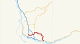
State Route 500, commonly known as SR 500, Highway 500, or 500, is a Washington state highway
located in Clark County, Washington
, United States
.
interchange with I-205
. It continues as a freeway for short period before traveling over local roads to the Padden Parkway where it meets with the southern terminus of SR 503
, the route then turns eastward to follow Padden Parkway to its terminus at Ward Rd. which SR 500 follows a short distance to N.E. 162nd Ave., where it turns south to 4th Plain Rd. From there it follows various local roads southeastward to its terminus just southeast of downtown Camas where it meets SR 14.
Due to a high accident rate and traffic volumes, Washington State Department of Transportation
is converting the expressway section of SR 500 between Interstate 5 and SR 503 to a freeway in phases. Three of the five planned interchanges have been completed, at N.E. Andresen Rd. (1995), N.E. Thurston Rd. (2002), and N.E. 112th Ave./N.E. Gher Rd. (2004). Two more interchanges and an overcrossing will complete the freeway at N.E. St. Johns Rd. (interchange), N.E. 42nd Ave. (overpass), and N.E. 54th Ave. (half-interchange, eastbound only).
Prior to 1964 SR 500 was designated SSH 8A
Prior to the construction of the freeway sections of SR 500, the route followed 4th Plain Rd. from I-5 to its current junction.
.
State highways in Washington
In the U.S. state of Washington, the Washington State Department of Transportation maintains a network of over 7000 miles of state highways, including all Interstate and U.S. Highways that pass through the state. The system comprises 8.5% of the state's public road mileage, but carries over half...
located in Clark County, Washington
Clark County, Washington
Clark County is a county located in the southwestern part of the U.S. state of Washington, across the Columbia River from Portland, Oregon.Clark County was the first county of Washington, named after William Clark of the Lewis and Clark Expedition...
, United States
United States
The United States of America is a federal constitutional republic comprising fifty states and a federal district...
.
Route description
SR 500 begins at an interchange with I-5 near downtown Vancouver, at the level of 39th Street. It runs eastward along an expressway to a traffic signal controlled intersections with St. Johns Blvd., Falk Rd., and NE 54 Ave. It then continues as an expressway past Westfield Shopping Town Vancouver (The Vancouver Mall) to a cloverleafCloverleaf
-Places:*Cloverleaf, Louisville, Kentucky, a neighborhood*Cloverleaf, Texas, a suburb of Houston*Cloverleaf Local School District in southern Medina County, Ohio-Science and technology:*A representation of the chemical structure of a transfer RNA molecule...
interchange with I-205
Interstate 205
Interstate 205 is the designation for two Interstate Highways in the United States, both of which are related to Interstate 5:*Interstate 205 , a connector in the San Francisco Bay Area...
. It continues as a freeway for short period before traveling over local roads to the Padden Parkway where it meets with the southern terminus of SR 503
Washington State Route 503
State Route 503, also known as the St. Helens South Roadway, is a state route through the state of Washington. It has a spur route, State Route 503 Spur. It has a Southern terminus at State Route 500 and a Northern terminus at Interstate 5....
, the route then turns eastward to follow Padden Parkway to its terminus at Ward Rd. which SR 500 follows a short distance to N.E. 162nd Ave., where it turns south to 4th Plain Rd. From there it follows various local roads southeastward to its terminus just southeast of downtown Camas where it meets SR 14.
Due to a high accident rate and traffic volumes, Washington State Department of Transportation
Washington State Department of Transportation
The Washington State Department of Transportation , was established in 1905. The agency, led by a Secretary and overseen by the Governor, is a Washington governmental agency that constructs, maintains, and regulates the use of the state's transportation infrastructure...
is converting the expressway section of SR 500 between Interstate 5 and SR 503 to a freeway in phases. Three of the five planned interchanges have been completed, at N.E. Andresen Rd. (1995), N.E. Thurston Rd. (2002), and N.E. 112th Ave./N.E. Gher Rd. (2004). Two more interchanges and an overcrossing will complete the freeway at N.E. St. Johns Rd. (interchange), N.E. 42nd Ave. (overpass), and N.E. 54th Ave. (half-interchange, eastbound only).
History
Prior to 2005, SR 500 followed 4th Plain Rd. from Orchards to its current junction instead of traveling north to Padden Parkway.Prior to 1964 SR 500 was designated SSH 8A
Prior to the construction of the freeway sections of SR 500, the route followed 4th Plain Rd. from I-5 to its current junction.
Major intersections
The entire route is in Clark CountyClark County, Washington
Clark County is a county located in the southwestern part of the U.S. state of Washington, across the Columbia River from Portland, Oregon.Clark County was the first county of Washington, named after William Clark of the Lewis and Clark Expedition...
.
| Location | Mile | Destinations | Notes |
|---|---|---|---|
| Vancouver Vancouver, Washington Vancouver is a city on the north bank of the Columbia River in the U.S. state of Washington. Incorporated in 1857, it is the fourth largest city in the state with a 2010 census population of 161,791 as of April 1, 2010... |
0.00 | – Portland Portland, Oregon Portland is a city located in the Pacific Northwest, near the confluence of the Willamette and Columbia rivers in the U.S. state of Oregon. As of the 2010 Census, it had a population of 583,776, making it the 29th most populous city in the United States... |
Westbound exit and eastbound entrance |
| 0.38 | Westbound exit and eastbound entrance | ||
| 1.13 | East end of freeway | ||
| 1.13 | St. Johns Boulevard | ||
| 2.38 | Northeast 54th Avenue | ||
| 2.38 | West end of freeway | ||
| 3.10 | Northeast Andresen Road | ||
| 3.88 | Northeast Thurston Way – Westfield Shoppingtown | ||
| 4.73 | , Salem Salem, Oregon Salem is the capital of the U.S. state of Oregon, and the county seat of Marion County. It is located in the center of the Willamette Valley alongside the Willamette River, which runs north through the city. The river forms the boundary between Marion and Polk counties, and the city neighborhood... |
||
| 5.40 | Northeast Gher Road, Northeast 112th Avenue | ||
| 5.96 | East end of freeway | ||
| 5.96 | Fourth Plain Boulevard – Orchards Orchards, Washington Orchards is a census-designated place in Clark County, Washington, United States. The population was 17,852 at the 2000 census.-Geography:Orchards is located at .... , Camas Camas, Washington Camas is a city in Clark County, Washington, with a population of 19,355 at the 2010 census. Officially incorporated on June 18, 1906, the city is named after the camas lily, a plant with an onion-like bulb prized by Native Americans. At the west end of downtown Camas is a large Georgia-Pacific... |
West end of SR 503 overlap; former SR 500 east | |
| 6.98 | East end of SR 503 overlap | ||
| Camas Camas, Washington Camas is a city in Clark County, Washington, with a population of 19,355 at the 2010 census. Officially incorporated on June 18, 1906, the city is named after the camas lily, a plant with an onion-like bulb prized by Native Americans. At the west end of downtown Camas is a large Georgia-Pacific... |
22.18 | ||