
Lake Washington Ship Canal
Encyclopedia
The Lake Washington Ship Canal, which runs through the City of Seattle, Washington, connects the fresh water body of Lake Washington
with the salt water inland sea of Puget Sound
. The Ship Canal includes a series of locks, modeled after the Panama Canal
, to accommodate the different water levels between Lake Washington and the Sound. The Canal runs east/west, and connects Union Bay
, Lake Union
, the Montlake Cut
, Portage Bay
, the Fremont Cut
, Salmon Bay
, and Shilshole Bay
, with the Sound, which empties into the Pacific Ocean
. The project began in 1911 and was officially completed in 1934.
As early as 1854, there was discussion of building a navigable connection between the Lake Washington and Puget Sound for the purpose of transporting logs, milled lumber, and fishing vessels. Thirteen years later, the United States Navy
endorsed a canal project, which included a plan for building a naval shipyard on Lake Washington. In 1891 the U.S. Army Corps of Engineers started planning the project. Some preliminary work was begun in 1906, and work began in earnest five years later. The delays in canal planning and construction resulted in the U.S. Navy building the Puget Sound Naval Shipyard
in Bremerton, Washington
, which is located across the Sound from Seattle.
The Canal's crossings, from east to west, are:
The Lake Washington Ship Canal and the Hiram M. Chittenden Locks
are listed on the National Register of Historic Places
. The Montlake Cut
, along with the Montlake Bridge
are City of Seattle Designated Landmarks (ID #107995).
Lake Washington
Lake Washington is a large freshwater lake adjacent to the city of Seattle. It is the largest lake in King County and the second largest in the state of Washington, after Lake Chelan. It is bordered by the cities of Seattle on the west, Bellevue and Kirkland on the east, Renton on the south and...
with the salt water inland sea of Puget Sound
Puget Sound
Puget Sound is a sound in the U.S. state of Washington. It is a complex estuarine system of interconnected marine waterways and basins, with one major and one minor connection to the Strait of Juan de Fuca and the Pacific Ocean — Admiralty Inlet being the major connection and...
. The Ship Canal includes a series of locks, modeled after the Panama Canal
Panama Canal
The Panama Canal is a ship canal in Panama that joins the Atlantic Ocean and the Pacific Ocean and is a key conduit for international maritime trade. Built from 1904 to 1914, the canal has seen annual traffic rise from about 1,000 ships early on to 14,702 vessels measuring a total of 309.6...
, to accommodate the different water levels between Lake Washington and the Sound. The Canal runs east/west, and connects Union Bay
Union Bay (Seattle)
Union Bay is that part of Lake Washington in Seattle that is west of a line drawn between Webster Point in the Laurelhurst neighborhood to the north and Foster Point in the Madison Park neighborhood to the south...
, Lake Union
Lake Union
Lake Union is a freshwater lake entirely within the Seattle, Washington city limits.-Origins:A glacial lake, its basin was dug 12,000 years ago by the Vashon glacier, which also created Lake Washington and Seattle's Green, Bitter, and Haller Lakes.-Name:...
, the Montlake Cut
Montlake Cut
The Montlake Cut is the easternmost section of the Lake Washington Ship Canal, which passes through the city of Seattle, linking Lake Washington to Puget Sound. It is approximately long and wide. The center channel is wide and deep....
, Portage Bay
Portage Bay
Portage Bay is an arm of Seattle, Washington's Lake Union and is part of the Lake Washington Ship Canal. Its western limit can be said to be the Ship Canal Bridge, which carries Interstate 5 over the water; North Passage Point Park and South Passage Point Park sit on opposite shores between the...
, the Fremont Cut
Fremont Cut
The Fremont Cut is a part of the Lake Washington Ship Canal—which passes through the U.S. city of Seattle, Washington, linking Lake Washington to Puget Sound—that connects Lake Union to the east with Salmon Bay to the west. It is long and wide. The center channel is wide and deep...
, Salmon Bay
Salmon Bay
Salmon Bay is that part of the Lake Washington Ship Canal--which passes through the city of Seattle, linking Lake Washington to Puget Sound--that lies west of the Fremont Cut. It is the westernmost section of the canal, and empties into Shilshole Bay, which is part of Puget Sound. Because of the...
, and Shilshole Bay
Shilshole Bay
Shilshole Bay is the part of Puget Sound east of a line drawn northeasterly from Seattle's West Point in the southwest to its Golden Gardens Park in the northeast. On its shores lie Discovery Park, the Lawtonwood section of the Magnolia neighborhood, the neighborhood of Ballard, and Golden Gardens...
, with the Sound, which empties into the Pacific Ocean
Pacific Ocean
The Pacific Ocean is the largest of the Earth's oceanic divisions. It extends from the Arctic in the north to the Southern Ocean in the south, bounded by Asia and Australia in the west, and the Americas in the east.At 165.2 million square kilometres in area, this largest division of the World...
. The project began in 1911 and was officially completed in 1934.
As early as 1854, there was discussion of building a navigable connection between the Lake Washington and Puget Sound for the purpose of transporting logs, milled lumber, and fishing vessels. Thirteen years later, the United States Navy
United States Navy
The United States Navy is the naval warfare service branch of the United States Armed Forces and one of the seven uniformed services of the United States. The U.S. Navy is the largest in the world; its battle fleet tonnage is greater than that of the next 13 largest navies combined. The U.S...
endorsed a canal project, which included a plan for building a naval shipyard on Lake Washington. In 1891 the U.S. Army Corps of Engineers started planning the project. Some preliminary work was begun in 1906, and work began in earnest five years later. The delays in canal planning and construction resulted in the U.S. Navy building the Puget Sound Naval Shipyard
Puget Sound Naval Shipyard
Puget Sound Naval Shipyard and Intermediate Maintenance Facility is a United States Navy shipyard covering 179 acres on Puget Sound at Bremerton, Washington...
in Bremerton, Washington
Bremerton, Washington
Bremerton is a city in Kitsap County, Washington, United States. The population was 38,790 at the 2011 State Estimate, making it the largest city on the Olympic Peninsula. Bremerton is home to Puget Sound Naval Shipyard and the Bremerton Annex of Naval Base Kitsap...
, which is located across the Sound from Seattle.
The Canal's crossings, from east to west, are:
- the Montlake BridgeMontlake BridgeThe Montlake Bridge is a double-leaf bascule bridge that carries Montlake Boulevard over Seattle's Montlake Cut--part of the Lake Washington Ship Canal--connecting Montlake and the University District....
carrying Montlake Boulevard over the Montlake CutMontlake CutThe Montlake Cut is the easternmost section of the Lake Washington Ship Canal, which passes through the city of Seattle, linking Lake Washington to Puget Sound. It is approximately long and wide. The center channel is wide and deep....
, - the University Bridge carrying Eastlake Avenue over Portage BayPortage BayPortage Bay is an arm of Seattle, Washington's Lake Union and is part of the Lake Washington Ship Canal. Its western limit can be said to be the Ship Canal Bridge, which carries Interstate 5 over the water; North Passage Point Park and South Passage Point Park sit on opposite shores between the...
, - the Ship Canal BridgeShip Canal BridgeThe Ship Canal Bridge is a double-deck steel truss bridge that carries Interstate 5 over Seattle's Portage Bay between Capitol Hill and the University District. The canal below connects Lake Union with Lake Washington. Construction was completed in 1961 and the bridge opened to traffic in...
carrying Interstate 5 over Portage BayPortage BayPortage Bay is an arm of Seattle, Washington's Lake Union and is part of the Lake Washington Ship Canal. Its western limit can be said to be the Ship Canal Bridge, which carries Interstate 5 over the water; North Passage Point Park and South Passage Point Park sit on opposite shores between the...
, - the George Washington Memorial BridgeGeorge Washington Memorial BridgeFor other bridges of the same name, see Washington Bridge .The George Washington Memorial Bridge is a cantilever and truss bridge that carries Aurora Avenue N. over the west end of Seattle's Lake Union between Queen Anne and Fremont, just east of the Fremont Cut...
(commonly called the Aurora Bridge) carrying Aurora Avenue N. (State Route 99Washington State Route 99State Route 99, abbreviated SR 99, commonly called Highway 99, is a numbered state highway in the U.S. state of Washington extending just under from Fife in the south to Everett in the north, with a gap in Tukwila.-Southern division:...
) over the west end of Lake UnionLake UnionLake Union is a freshwater lake entirely within the Seattle, Washington city limits.-Origins:A glacial lake, its basin was dug 12,000 years ago by the Vashon glacier, which also created Lake Washington and Seattle's Green, Bitter, and Haller Lakes.-Name:...
, - the Fremont Bridge connecting 4th Avenue N. to Fremont Avenue N. over the Fremont CutFremont CutThe Fremont Cut is a part of the Lake Washington Ship Canal—which passes through the U.S. city of Seattle, Washington, linking Lake Washington to Puget Sound—that connects Lake Union to the east with Salmon Bay to the west. It is long and wide. The center channel is wide and deep...
, - the Ballard BridgeBallard BridgeThe Ballard Bridge, also known as the 15th Avenue Bridge, is a double-leaf bascule bridge in Seattle, Washington, United States. It carries 15th Avenue NW over Seattle's Salmon Bay between Ballard and Interbay. Built in 1917, it has an opening span of and a total length of . It was added to the...
carrying 15th Avenue over Salmon BaySalmon BaySalmon Bay is that part of the Lake Washington Ship Canal--which passes through the city of Seattle, linking Lake Washington to Puget Sound--that lies west of the Fremont Cut. It is the westernmost section of the canal, and empties into Shilshole Bay, which is part of Puget Sound. Because of the...
, - pedestrian crossing only at the Hiram M. Chittenden LocksHiram M. Chittenden LocksThe Hiram M. Chittenden Locks are a complex of locks that sit at the west end of Salmon Bay, part of Seattle's Lake Washington Ship Canal. They are known locally as the Ballard Locks after the neighborhood to their north...
, - the BNSF RailwayBNSF RailwayThe BNSF Railway is a wholly owned subsidiary of Berkshire Hathaway Inc., and is headquartered in Fort Worth, Texas. It is one of seven North American Class I railroads and the second largest freight railroad network in North America, second only to the Union Pacific Railroad, its primary...
's Salmon Bay Bridge over Salmon BaySalmon BaySalmon Bay is that part of the Lake Washington Ship Canal--which passes through the city of Seattle, linking Lake Washington to Puget Sound--that lies west of the Fremont Cut. It is the westernmost section of the canal, and empties into Shilshole Bay, which is part of Puget Sound. Because of the...
.
The Lake Washington Ship Canal and the Hiram M. Chittenden Locks
Hiram M. Chittenden Locks
The Hiram M. Chittenden Locks are a complex of locks that sit at the west end of Salmon Bay, part of Seattle's Lake Washington Ship Canal. They are known locally as the Ballard Locks after the neighborhood to their north...
are listed on the National Register of Historic Places
National Register of Historic Places
The National Register of Historic Places is the United States government's official list of districts, sites, buildings, structures, and objects deemed worthy of preservation...
. The Montlake Cut
Montlake Cut
The Montlake Cut is the easternmost section of the Lake Washington Ship Canal, which passes through the city of Seattle, linking Lake Washington to Puget Sound. It is approximately long and wide. The center channel is wide and deep....
, along with the Montlake Bridge
Montlake Bridge
The Montlake Bridge is a double-leaf bascule bridge that carries Montlake Boulevard over Seattle's Montlake Cut--part of the Lake Washington Ship Canal--connecting Montlake and the University District....
are City of Seattle Designated Landmarks (ID #107995).
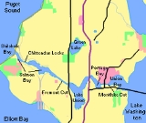
 |
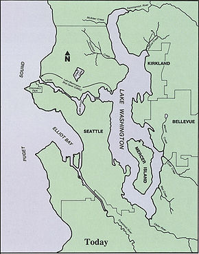 |
| Seattle's waterways in 1902, before the canal was built. | Seattle's waterways in the 1990s, showing the effect of the canal (and of other projects, such as the undergrounding of many streams and the re-routing, dredging, and industrialization of the Duwamish River Duwamish River The Duwamish River is the name of the lower of Washington state's Green River. Its industrialized estuary is known as the Duwamish Waterway.- History :... ). (The map remains essentially accurate as of 2009.) |