
Washington State Route 510
Encyclopedia
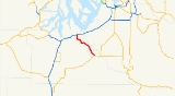
State Route 510 is a 13.07 miles (21.03 km) long state highway
in Thurston County, a subdivision of the U.S. state
of Washington. The highway extends southeast from an interchange with (I-5) in Lacey
to in Yelm
. SR 510 roughly parallels the Nisqually River
, the border between Thurston and Pierce
counties, between the Fort Lewis
and Nisqually Indian Community
area to Yelm. Five educational institutions, including one community college
and two high schools, are served by the route. The roadway was built by 1916 as a connector from Saint Clair Lake to the Northern Pacific Railway
station in Yelm and was designated as Secondary State Highway 5I (SSH 5I) in 1937. The original route of SSH 5I ran from Tumwater
east to Yelm, following the present-day Yelm Highway. In 1959, the highway was realigned to serve a new freeway, later I-5, in Lacey; SSH 5I was replaced in the 1964 highway renumbering by SR 510. The Yelm-Tenino Trail
was built over the Northern Pacific line in 1993 and a bypass
is being constructed around Yelm.
on (I-5) in southern Lacey
. The highway travels south by the Hawks Prairie Village Mall, home of the Hawks Prairie Center, a division of the South Puget Sound Community College
. South of the mall is the Martin Way intersection, located west of River Ridge High School and one of the busiest intersections on the roadway at a daily average of 24,000 motorists in 2008, and the Pacific Avenue roundabout
, where SR 510 turns east, renamed Pacific Avenue, northeast of Long Lake
. After leaving Lacey city limits
, the roadway begins to parallel the Quadlok line owned by Tacoma Rail
south towards the Old Pacific Highway. At the Old Pacific Highway, the road becomes the St. Clair Cutoff Road, named for nearby Saint Clair Lake, and crosses the railroad tracks twice. After turning northeast, parallel to Saint Clair Lake's shoreline, the highway dips southeast, now parallel to the Nisqually River
, into Fort Lewis
and the Nisqually Indian Community
. Outside of the community, SR 510 is renamed the Yelm Highway and passes Southworth Elementary. After intersecting Mudd Run Road, future western terminus of the Yelm Loop, the roadway enters Yelm
city limits. After turning southeast, SR 510 becomes Yelm Avenue and serves Yelm High School
. Shortly thereafter, the roadway serves Yelm Middle School, crosses the Yelm-Tenino Trail
, a 7.4 miles (11.9 km) long rail trail
in operation since 1993, and ends at First Street, signed as , which continues southeast as Yelm Avenue.
station at Yelm
, constructed by 1916. The road later extended west to Tumwater
and designated Secondary State Highway 5I (SSH 5I) in 1937. The old route followed present-day Yelm Highway on the southern side of Saint Clair Lake and Patterson Lake to Tumwater. In 1959, SSH 5I was moved to a northern route to the (US 99) and freeway in Lacey
. SR 510 officially replaced SSH 5I after the 1964 highway renumbering; US 99 and US 410 also became (I-5) in 1968.
SR 510 between I-5 and Pacific Avenue and Marvin Road, which connects to River Ridge High School, were reconstructed and widened in late 2003. A 120 feet (36.58 m) wide, 2 lane bypass
of Yelm, named the Yelm Loop, is, as of 2009, being constructed near SR 510. The bypass will begin at a roundabout
with SR 510 near the current Mudd Run Road intersection and travel east through a residential and industral area to intersect Wilkensen Road in another roundabout. The highway will turn south, pass a city park and end at a traffic signal with SR 507 east of Yelm. The project is being divided into two stages: Stage 1 will construct the roadway between SR 510 and Cullens Road and has been funded, which Stage 2 will finish the roadway to SR 507 and this segment is currently unfunded. Plans for the road were created in 2004 and the Washington State Legislature
funded Stage 1 in 2009 and the city is actively anticipating the new highway that will redirect traffic that has increased since the 1990s.
State highways in Washington
In the U.S. state of Washington, the Washington State Department of Transportation maintains a network of over 7000 miles of state highways, including all Interstate and U.S. Highways that pass through the state. The system comprises 8.5% of the state's public road mileage, but carries over half...
in Thurston County, a subdivision of the U.S. state
U.S. state
A U.S. state is any one of the 50 federated states of the United States of America that share sovereignty with the federal government. Because of this shared sovereignty, an American is a citizen both of the federal entity and of his or her state of domicile. Four states use the official title of...
of Washington. The highway extends southeast from an interchange with (I-5) in Lacey
Lacey, Washington
Lacey is a city in Thurston County, Washington, United States. Established as a suburb of Olympia, its population was 42,393 at the 2010 census out of a county population of 252,264.-History:...
to in Yelm
Yelm, Washington
Yelm is a city in Thurston County, Washington, United States. The population was 6,848 at the 2010 census. Yelm ranked 10th of 279 eligible incorporated communities in the state of Washington for population growth between 2000 and 2010.-History:...
. SR 510 roughly parallels the Nisqually River
Nisqually River
The Nisqually River is a river in west central Washington in the United States, approximately long. It drains part of the Cascade Range southwest of Tacoma, including the southern slope of Mount Rainier, and empties into the southern end of Puget Sound....
, the border between Thurston and Pierce
Pierce County, Washington
right|thumb|[[Tacoma, Washington|Tacoma]] - Seat of Pierce CountyPierce County is the second most populous county in the U.S. state of Washington. Formed out of Thurston County on December 22, 1852, by the legislature of Oregon Territory...
counties, between the Fort Lewis
Fort Lewis
Joint Base Lewis-McChord is a United States military facility located south-southwest of Tacoma, Washington. The facility is under the jurisdiction of the United States Army Joint Base Garrison, Joint Base Lewis-McChord....
and Nisqually Indian Community
Nisqually Indian Community, Washington
Nisqually Indian Community is a census-designated place in Thurston County, Washington, United States. The population was 588 at the 2000 census.-Geography:Nisqually Indian Community is located at ....
area to Yelm. Five educational institutions, including one community college
Community college
A community college is a type of educational institution. The term can have different meanings in different countries.-Australia:Community colleges carry on the tradition of adult education, which was established in Australia around mid 19th century when evening classes were held to help adults...
and two high schools, are served by the route. The roadway was built by 1916 as a connector from Saint Clair Lake to the Northern Pacific Railway
Northern Pacific Railway
The Northern Pacific Railway was a railway that operated in the west along the Canadian border of the United States. Construction began in 1870 and the main line opened all the way from the Great Lakes to the Pacific when former president Ulysses S. Grant drove in the final "golden spike" in...
station in Yelm and was designated as Secondary State Highway 5I (SSH 5I) in 1937. The original route of SSH 5I ran from Tumwater
Tumwater, Washington
Tumwater is a city in Thurston County, Washington, United States. It lies near where the Deschutes River enters Budd Inlet, the southernmost point of Puget Sound. The population was 17,371 at the 2010 census...
east to Yelm, following the present-day Yelm Highway. In 1959, the highway was realigned to serve a new freeway, later I-5, in Lacey; SSH 5I was replaced in the 1964 highway renumbering by SR 510. The Yelm-Tenino Trail
Yelm-Tenino Trail
The Yelm–Tenino Trail is a rail trail located in Thurston County, Washington, US. The long cycling and walking trail has been constructed along the route of a former Burlington Northern Railroad line...
was built over the Northern Pacific line in 1993 and a bypass
Bypass (road)
A bypass is a road or highway that avoids or "bypasses" a built-up area, town, or village, to let through traffic flow without interference from local traffic, to reduce congestion in the built-up area, and to improve road safety....
is being constructed around Yelm.
Route description
SR 510 begins as Marvin Road at exit 111, a diamond interchangeDiamond interchange
A diamond interchange is a common type of road junction, used where a freeway crosses a minor road. The freeway itself is grade-separated from the minor road, one crossing the other over a bridge...
on (I-5) in southern Lacey
Lacey, Washington
Lacey is a city in Thurston County, Washington, United States. Established as a suburb of Olympia, its population was 42,393 at the 2010 census out of a county population of 252,264.-History:...
. The highway travels south by the Hawks Prairie Village Mall, home of the Hawks Prairie Center, a division of the South Puget Sound Community College
South Puget Sound Community College
South Puget Sound Community College is a community college located in southwest Olympia, Washington, USA. It is located in a residential area just off the junction between US Route 101 and Interstate 5...
. South of the mall is the Martin Way intersection, located west of River Ridge High School and one of the busiest intersections on the roadway at a daily average of 24,000 motorists in 2008, and the Pacific Avenue roundabout
Roundabout
A roundabout is the name for a road junction in which traffic moves in one direction around a central island. The word dates from the early 20th century. Roundabouts are common in many countries around the world...
, where SR 510 turns east, renamed Pacific Avenue, northeast of Long Lake
Long Lake (Thurston County, Washington)
Long Lake is a freshwater lake located in Thurston County, Washington, United States. It is located approximately 5.5 miles east of Olympia. It consists of two basins connected by a narrow neck. It is two miles long and has two islands, Holmes Island and Kirby Island...
. After leaving Lacey city limits
City limits
The terms city limits and city boundary refer to the defined boundary or border of a city. The area within the city limits is sometimes called the city proper. The terms town limits/boundary and village limits/boundary mean the same as city limits/boundary, but apply to towns and villages...
, the roadway begins to parallel the Quadlok line owned by Tacoma Rail
Tacoma Rail
Tacoma Rail is a shortline railroad. It is operated as a public utility and owned by the city of Tacoma, Washington as part of the municipally-owned Tacoma Public Utilities service. It provides rail services for freight switching...
south towards the Old Pacific Highway. At the Old Pacific Highway, the road becomes the St. Clair Cutoff Road, named for nearby Saint Clair Lake, and crosses the railroad tracks twice. After turning northeast, parallel to Saint Clair Lake's shoreline, the highway dips southeast, now parallel to the Nisqually River
Nisqually River
The Nisqually River is a river in west central Washington in the United States, approximately long. It drains part of the Cascade Range southwest of Tacoma, including the southern slope of Mount Rainier, and empties into the southern end of Puget Sound....
, into Fort Lewis
Fort Lewis
Joint Base Lewis-McChord is a United States military facility located south-southwest of Tacoma, Washington. The facility is under the jurisdiction of the United States Army Joint Base Garrison, Joint Base Lewis-McChord....
and the Nisqually Indian Community
Nisqually Indian Community, Washington
Nisqually Indian Community is a census-designated place in Thurston County, Washington, United States. The population was 588 at the 2000 census.-Geography:Nisqually Indian Community is located at ....
. Outside of the community, SR 510 is renamed the Yelm Highway and passes Southworth Elementary. After intersecting Mudd Run Road, future western terminus of the Yelm Loop, the roadway enters Yelm
Yelm, Washington
Yelm is a city in Thurston County, Washington, United States. The population was 6,848 at the 2010 census. Yelm ranked 10th of 279 eligible incorporated communities in the state of Washington for population growth between 2000 and 2010.-History:...
city limits. After turning southeast, SR 510 becomes Yelm Avenue and serves Yelm High School
Yelm High School
Yelm High School is a comprehensive high school in the city of Yelm, Washington, part of the Yelm Community Schools.Yelm is said to have received its mascot the "Yelm Tornado" after a small tornado blew through the small town in the early 20th century....
. Shortly thereafter, the roadway serves Yelm Middle School, crosses the Yelm-Tenino Trail
Yelm-Tenino Trail
The Yelm–Tenino Trail is a rail trail located in Thurston County, Washington, US. The long cycling and walking trail has been constructed along the route of a former Burlington Northern Railroad line...
, a 7.4 miles (11.9 km) long rail trail
Rail trail
A rail trail is the conversion of a disused railway easement into a multi-use path, typically for walking, cycling and sometimes horse riding. The characteristics of former tracks—flat, long, frequently running through historical areas—are appealing for various development. The term sometimes also...
in operation since 1993, and ends at First Street, signed as , which continues southeast as Yelm Avenue.
History
SR 510 began as an unsigned county-maintained road that ran from the Saint Clair Lake area to the Northern Pacific RailwayNorthern Pacific Railway
The Northern Pacific Railway was a railway that operated in the west along the Canadian border of the United States. Construction began in 1870 and the main line opened all the way from the Great Lakes to the Pacific when former president Ulysses S. Grant drove in the final "golden spike" in...
station at Yelm
Yelm, Washington
Yelm is a city in Thurston County, Washington, United States. The population was 6,848 at the 2010 census. Yelm ranked 10th of 279 eligible incorporated communities in the state of Washington for population growth between 2000 and 2010.-History:...
, constructed by 1916. The road later extended west to Tumwater
Tumwater, Washington
Tumwater is a city in Thurston County, Washington, United States. It lies near where the Deschutes River enters Budd Inlet, the southernmost point of Puget Sound. The population was 17,371 at the 2010 census...
and designated Secondary State Highway 5I (SSH 5I) in 1937. The old route followed present-day Yelm Highway on the southern side of Saint Clair Lake and Patterson Lake to Tumwater. In 1959, SSH 5I was moved to a northern route to the (US 99) and freeway in Lacey
Lacey, Washington
Lacey is a city in Thurston County, Washington, United States. Established as a suburb of Olympia, its population was 42,393 at the 2010 census out of a county population of 252,264.-History:...
. SR 510 officially replaced SSH 5I after the 1964 highway renumbering; US 99 and US 410 also became (I-5) in 1968.
SR 510 between I-5 and Pacific Avenue and Marvin Road, which connects to River Ridge High School, were reconstructed and widened in late 2003. A 120 feet (36.58 m) wide, 2 lane bypass
Bypass (road)
A bypass is a road or highway that avoids or "bypasses" a built-up area, town, or village, to let through traffic flow without interference from local traffic, to reduce congestion in the built-up area, and to improve road safety....
of Yelm, named the Yelm Loop, is, as of 2009, being constructed near SR 510. The bypass will begin at a roundabout
Roundabout
A roundabout is the name for a road junction in which traffic moves in one direction around a central island. The word dates from the early 20th century. Roundabouts are common in many countries around the world...
with SR 510 near the current Mudd Run Road intersection and travel east through a residential and industral area to intersect Wilkensen Road in another roundabout. The highway will turn south, pass a city park and end at a traffic signal with SR 507 east of Yelm. The project is being divided into two stages: Stage 1 will construct the roadway between SR 510 and Cullens Road and has been funded, which Stage 2 will finish the roadway to SR 507 and this segment is currently unfunded. Plans for the road were created in 2004 and the Washington State Legislature
Washington State Legislature
The Washington State Legislature is the state legislature of the U.S. state of Washington. It is a bipartisan, bicameral body, composed of the lower Washington House of Representatives, composed of 98 Representatives, and the upper Washington State Senate, with 49 Senators.The State Legislature...
funded Stage 1 in 2009 and the city is actively anticipating the new highway that will redirect traffic that has increased since the 1990s.
Major intersections
The entire route is located in Thurston County.| Location | Mile | Destinations | Notes |
|---|---|---|---|
| Lacey Lacey, Washington Lacey is a city in Thurston County, Washington, United States. Established as a suburb of Olympia, its population was 42,393 at the 2010 census out of a county population of 252,264.-History:... |
0.00 | Western terminus | |
| Yelm Yelm, Washington Yelm is a city in Thurston County, Washington, United States. The population was 6,848 at the 2010 census. Yelm ranked 10th of 279 eligible incorporated communities in the state of Washington for population growth between 2000 and 2010.-History:... |
13.07 | Eastern terminus |