
Washington State Route 528
Encyclopedia
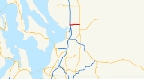
State Route 528 is a state highway located entirely in the city of Marysville
within Snohomish County, Washington
. It extends 3.46 miles (5.57 km) from an interchange with Interstate 5
(I-5) through Downtown Marysville, east to SR 9. The route serves as a connector to Downtown Marysville. The highway formerly was part of the Marysville branch of Primary State Highway 1 (PSH 1 MA) from 1937 until 1964. In 1964, PSH 1 MA became SR 528.
(I-5) east to SR 9, entirely in Marysville
. The route serves as a connector to Downtown Marysville. WSDOT has found that more than 35,000 motorists utilize the road daily after the I-5 interchange based on average annual daily traffic (AADT) data.
Starting at I-5 exit 199 on the Marysville–Tulalip Indian Reservation boundary, the highway, which continues northwest as Marine Drive 20.7 miles (33.31 km) to Stanwood
, becomes Fourth Street. After the interchange with I-5, SR 528 intersects Beach Avenue and Cedar Avenue before crossing two railroad tracks that are owned by the Burlington Northern Santa Fe Railway
. The railroad goes south to Seattle and north to Vancouver, BC. Immediately after the railroad crossing, the road starts forming the northern boundary of the Marysville Mall and intersects Delta Avenue before intersecting State Avenue, known as SR 529 and the former route of U.S. Route 99
(US 99).
Then, the highway intersects 47th Avenue, also known as Armar Road, before going northwest to cross Allen Creek; SR 528 forms the southern boundary of Jennings Memorial Park at this point. The highway becomes 64th Street and goes due east for the rest of its route. SR 528 intersects 60th Drive, which serves as a connector to the Marysville YMCA
; the road also serves Allen Creek Elementary, which is part of the Marysville School District. The road then intersects 67th Avenue, a major road that goes north 9.71 miles (15.63 km) to Arlington
. After the intersection, SR 528 crosses Munson Creek and passes Foothills Park before ending at an intersection with SR 9.
 When the Primary and Secondary Highways were created in 1937, the route of SR 528 became the Marysville
branch of Primary State Highway 1 (PSH 1 MA). PSH 1 MA ran from PSH 1 in Marysville to Secondary State Highway 1A (SSH 1A). PSH 1 MA became SR 528 in 1964 during the 1964 highway renumbering, in which the Washington State Department of Transportation
(WSDOT) replaced the previous system of Primary and Secondary Highways with a new system called State Routes
, which is still in use today.
Numerous construction projects have happened along the SR 528 corridor, even though its only 3.46 miles (5.57 km) long. The first of these projects, a repaving project, happened in September 2004. The Washington State Department of Transportation
(WSDOT) repaved the road near Downtown Marysville. The second project involved reconfiguring the SR 528 / SR 9 interchange, by adding a traffic light
, wider shoulders and a left-turn lane. The third and latest project, another repaving project, was done during the summer of 2008 and finished in October 2008. WSDOT repaved SR 528 from the I-5 interchange to SR 529, about a 0.36 mile (0.5793624 km) long segment. The project started on June 15, 2008, but didn't end until October 15.
Marysville, Washington
Marysville is a city in Snohomish County, Washington, United States. The population was 60,020 at the 2010 census. Marysville is known as "The Strawberry City" due to the large number of strawberry farms that once surrounded the city in its earlier days. Over the past decade, and continuing...
within Snohomish County, Washington
Snohomish County, Washington
Snohomish County is a county located in the U.S. state of Washington. It is named after the Snohomish tribe. Since 2000, the county's population has grown from 606,024 to 713,335 residents , making it one of the fastest-growing in the state, ranking third in overall population after King and...
. It extends 3.46 miles (5.57 km) from an interchange with Interstate 5
Interstate 5 in Washington
Interstate 5 in Washington is a highway in the U.S. state of Washington that extends from its border with Oregon to its border with Canada...
(I-5) through Downtown Marysville, east to SR 9. The route serves as a connector to Downtown Marysville. The highway formerly was part of the Marysville branch of Primary State Highway 1 (PSH 1 MA) from 1937 until 1964. In 1964, PSH 1 MA became SR 528.
Route description
State Route 528 (SR 528) runs 3.46 miles (5.57 km) from an interchange with Interstate 5Interstate 5 in Washington
Interstate 5 in Washington is a highway in the U.S. state of Washington that extends from its border with Oregon to its border with Canada...
(I-5) east to SR 9, entirely in Marysville
Marysville, Washington
Marysville is a city in Snohomish County, Washington, United States. The population was 60,020 at the 2010 census. Marysville is known as "The Strawberry City" due to the large number of strawberry farms that once surrounded the city in its earlier days. Over the past decade, and continuing...
. The route serves as a connector to Downtown Marysville. WSDOT has found that more than 35,000 motorists utilize the road daily after the I-5 interchange based on average annual daily traffic (AADT) data.
Starting at I-5 exit 199 on the Marysville–Tulalip Indian Reservation boundary, the highway, which continues northwest as Marine Drive 20.7 miles (33.31 km) to Stanwood
Stanwood, Washington
Stanwood is a city in Snohomish County, Washington, United States. The population was 6,231 at the 2010 census.-History:Stanwood was first settled in 1866 by Robert Fulton. Stanwood's Post Office was established as Centerville in 1870, and the name was changed to Stanwood in 1877 by D.O. Pearson...
, becomes Fourth Street. After the interchange with I-5, SR 528 intersects Beach Avenue and Cedar Avenue before crossing two railroad tracks that are owned by the Burlington Northern Santa Fe Railway
BNSF Railway
The BNSF Railway is a wholly owned subsidiary of Berkshire Hathaway Inc., and is headquartered in Fort Worth, Texas. It is one of seven North American Class I railroads and the second largest freight railroad network in North America, second only to the Union Pacific Railroad, its primary...
. The railroad goes south to Seattle and north to Vancouver, BC. Immediately after the railroad crossing, the road starts forming the northern boundary of the Marysville Mall and intersects Delta Avenue before intersecting State Avenue, known as SR 529 and the former route of U.S. Route 99
U.S. Route 99
U.S. Route 99 was the main north–south highway on the West Coast of the United States until 1964, running from Calexico, California, on the U.S.-Mexico border to Blaine, Washington, on the U.S.-Canada border. It was a route of the United States Numbered Highways, assigned in 1926 and existing...
(US 99).
Then, the highway intersects 47th Avenue, also known as Armar Road, before going northwest to cross Allen Creek; SR 528 forms the southern boundary of Jennings Memorial Park at this point. The highway becomes 64th Street and goes due east for the rest of its route. SR 528 intersects 60th Drive, which serves as a connector to the Marysville YMCA
YMCA
The Young Men's Christian Association is a worldwide organization of more than 45 million members from 125 national federations affiliated through the World Alliance of YMCAs...
; the road also serves Allen Creek Elementary, which is part of the Marysville School District. The road then intersects 67th Avenue, a major road that goes north 9.71 miles (15.63 km) to Arlington
Arlington, Washington
Arlington is a city in northern Snohomish County, Washington, United States, bordered by the city of Marysville to the south. The population was 17,926 at the 2010 census.-History:...
. After the intersection, SR 528 crosses Munson Creek and passes Foothills Park before ending at an intersection with SR 9.
History
Marysville, Washington
Marysville is a city in Snohomish County, Washington, United States. The population was 60,020 at the 2010 census. Marysville is known as "The Strawberry City" due to the large number of strawberry farms that once surrounded the city in its earlier days. Over the past decade, and continuing...
branch of Primary State Highway 1 (PSH 1 MA). PSH 1 MA ran from PSH 1 in Marysville to Secondary State Highway 1A (SSH 1A). PSH 1 MA became SR 528 in 1964 during the 1964 highway renumbering, in which the Washington State Department of Transportation
Washington State Department of Transportation
The Washington State Department of Transportation , was established in 1905. The agency, led by a Secretary and overseen by the Governor, is a Washington governmental agency that constructs, maintains, and regulates the use of the state's transportation infrastructure...
(WSDOT) replaced the previous system of Primary and Secondary Highways with a new system called State Routes
State highways in Washington
In the U.S. state of Washington, the Washington State Department of Transportation maintains a network of over 7000 miles of state highways, including all Interstate and U.S. Highways that pass through the state. The system comprises 8.5% of the state's public road mileage, but carries over half...
, which is still in use today.
Numerous construction projects have happened along the SR 528 corridor, even though its only 3.46 miles (5.57 km) long. The first of these projects, a repaving project, happened in September 2004. The Washington State Department of Transportation
Washington State Department of Transportation
The Washington State Department of Transportation , was established in 1905. The agency, led by a Secretary and overseen by the Governor, is a Washington governmental agency that constructs, maintains, and regulates the use of the state's transportation infrastructure...
(WSDOT) repaved the road near Downtown Marysville. The second project involved reconfiguring the SR 528 / SR 9 interchange, by adding a traffic light
Traffic light
Traffic lights, which may also be known as stoplights, traffic lamps, traffic signals, signal lights, robots or semaphore, are signalling devices positioned at road intersections, pedestrian crossings and other locations to control competing flows of traffic...
, wider shoulders and a left-turn lane. The third and latest project, another repaving project, was done during the summer of 2008 and finished in October 2008. WSDOT repaved SR 528 from the I-5 interchange to SR 529, about a 0.36 mile (0.5793624 km) long segment. The project started on June 15, 2008, but didn't end until October 15.
Major intersections
| County | Location | Mile | Destinations | Notes |
|---|---|---|---|---|
| Snohomish Snohomish County, Washington Snohomish County is a county located in the U.S. state of Washington. It is named after the Snohomish tribe. Since 2000, the county's population has grown from 606,024 to 713,335 residents , making it one of the fastest-growing in the state, ranking third in overall population after King and... |
Marysville Marysville, Washington Marysville is a city in Snohomish County, Washington, United States. The population was 60,020 at the 2010 census. Marysville is known as "The Strawberry City" due to the large number of strawberry farms that once surrounded the city in its earlier days. Over the past decade, and continuing... |
0.00 | Western terminus; I-5 exit 199 | |
| 0.36 | Northern terminus of SR 529; Former US 99 | |||
| 0.80 | 47th Avenue, Armar Road | |||
| 3.46 | Eastern terminus |