

U.S. Route 101 in Washington
Encyclopedia
In the U.S. state
of Washington, U.S. Route 101 is the westernmost state highway
, serving the Olympic Peninsula
. It runs from the Astoria-Megler Bridge
north to the cities of Raymond
, Aberdeen
, Hoquiam
, and Forks
before turning east at the small community of Beaver to the most northern point of the highway at Port Angeles
, then south to Tumwater
.
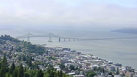 US 101 in Washington begins at the Astoria-Megler Bridge
on the Columbia River
, carrying traffic to and from Astoria
, Oregon
. The first highway US 101 intersects is SR 401.
After going north for a few miles, US 101 turns west after intersecting with US 101 Alternate, which is a shortcut to itself. The route goes west to Ilwaco
and north to Long Beach
, where it intersects SR 100
and SR 103
before finally turning east back to US 101 Alt.
Soon, US 101 turns north towards Raymond
and intersects the west end of SR 4, before going to Downtown Raymond. In Downtown, US 101 intersects the western end of SR 6 and southern end of SR 105, which it will intersect again in Cosmopolis
.
After intersecting with SR 105 and SR 107, US 101 crosses the Chehalis River, which leads the highway to the western end of US 12
in Aberdeen
. The roadway turns southwest and splits into two streets for each direction until it reaches Hoquiam
, where it intersects the southern end of SR 109
and the eastern end of SR 109 Spur.
 US 101 then turns north to the Quinault Indian Reservation and then into the isolated area bordered by Olympic National Park
and the Quinault Indian Reservation. After turning east at Lake Quinault
and entering the Quinault Indian Reservation again, US 101 goes north to the Olympic National Park
on the Pacific
coast.
The road then curves north Forks
and north to Beaver, where it turns east after intersecting with SR 113 and touching the shore of Lake Pleasant. After a mile of going east, US 101 enters its second segment in the Olympic National Park
, about one-mile (1.6 km) east of the west shore of Lake Crescent and then exits at the eastern shore of the same lake.
After exiting park boundaries, US 101 intersects SR 112. Shortly later, it intersects SR 117 (the Tumwater Truck Route) in an odd interchange/intersection hybrid. It then enters Port Angeles
and turns onto Lincoln Street. It then turns onto a one-way couplet of First and Front streets, which lasts until Golf Course Road. There, the roads merge into one four-lane road, divided only by a two-way left turn lane, and leave Port Angles. After going through the dangerous Morse Creek S-Curves, the highway turns into a divided expressway.
After a short 2-lane road, US 101 turns again into a expressway
west of Carlsborg
, it enters the town of Sequim
and turns into a super-two expressway, bypassing the town. East of Sequim, the road turns back into a standard two-lane road and goes to Sequim Bay
and then Discovery Bay
, where it intersects SR 20 and turns south. After a short distance, US 101 intersects the western end of SR 104. The road then turns south to Dabob Bay, where it follows the shore until it reaches the Hood Canal
.
At the Hood Canal
, US 101 follows the western shore to SR 106, where it turns directly south to the east end of SR 106 and Shelton
, to meet the west end of SR 3. After some time going south, US 101 meets SR 108, the second-to-last major junction. After going southeast, US 101 finally joins SR 8 and turns into a freeway to its easternmost point of US 101 in Washington, the so called "north end" at I-5
near Tumwater
.

 Before U.S. Route 101
was created, two roads existed in the place of US 101. They were State Road 9 and State Road 12. These were two roads that were part of the early Washington State Road system that was created in 1923. US 101 was created in 1926 and was co-signed with these two routes. US 101 took part of State Road 9's route and part of State Road 12's route.
In 1937, the Washington State Legislature established a new system, the Primary and secondary system. State Road 9 became Primary State Highway 9 or PSH 9. State Road 12 became PSH 12, and they both held the co-signed designation with US 101.
There was nothing changed about US 101's route from 1937 to 1956. In 1956, President
Dwight D. Eisenhower
signed the Interstate Highway Act into law. This eliminated part of the U.S. Route system
and encouraged Washington's Legislature to once again change the highway system.
In January 1964, the Washington State Legislature and the Washington Department of Highways (renamed WSDOT
) approved a new state route system with no branches or secondary route with names, but a full system that lives on today. PSH 9 and PSH 12 became part of U.S. Route 101 with no co-designation and parts of them became other new state routes.
. US 101 Alt. opened in 1931 as a branch of PSH 12, the early designation of the southern section of US 101 through Washington. The highway was not fully recognized by the AASHTO until October 2006, even though many maps from the 1930s state that it is part of the U.S. Route system.
U.S. state
A U.S. state is any one of the 50 federated states of the United States of America that share sovereignty with the federal government. Because of this shared sovereignty, an American is a citizen both of the federal entity and of his or her state of domicile. Four states use the official title of...
of Washington, U.S. Route 101 is the westernmost state highway
State highway
State highway, state road or state route can refer to one of three related concepts, two of them related to a state or provincial government in a country that is divided into states or provinces :#A...
, serving the Olympic Peninsula
Olympic Peninsula
The Olympic Peninsula is the large arm of land in western Washington state of the USA, that lies across Puget Sound from Seattle. It is bounded on the west by the Pacific Ocean, the north by the Strait of Juan de Fuca, and the east by Puget Sound. Cape Alava, the westernmost point in the contiguous...
. It runs from the Astoria-Megler Bridge
Astoria-Megler Bridge
The Astoria–Megler Bridge is a steel girder continuous truss bridge that spans the Columbia River between Astoria, Oregon and Point Ellice near Megler, Washington, in the United States. The span is from the mouth of the river, and was the last segment of U.S. Route 101 between Olympia, Washington...
north to the cities of Raymond
Raymond, Washington
Raymond is a city in Pacific County, Washington, United States. The population was 2,975 at the 2000 census and decreased 3.1% to 2,882 at the 2010 census. The town's economy is based on logging and fishing, together with a limited amount of tourism....
, Aberdeen
Aberdeen, Washington
Aberdeen is a city in Grays Harbor County, Washington, United States, founded by Samuel Benn in 1884. Aberdeen was incorporated on May 12, 1890. The city is the economic center of Grays Harbor County, bordering the cities of Hoquiam and Cosmopolis...
, Hoquiam
Hoquiam, Washington
Hoquiam is a city in Grays Harbor County, Washington state, United States. The town borders the city of Aberdeen at Myrtle Street with Hoquiam to the west. The two cities share a common economic history in lumbering and exporting but Hoquiam has maintained its independent identity...
, and Forks
Forks, Washington
-Government:The City is organized under Washington State law as a Non-charter Code City. Its structure is that of an elected Mayor and a five member elected City Council...
before turning east at the small community of Beaver to the most northern point of the highway at Port Angeles
Port Angeles, Washington
Port Angeles is a city in and the county seat of Clallam County, Washington, United States. The population was 19,038 at the 2010 census. The area's harbor was dubbed Puerto de Nuestra Señora de los Ángeles by Spanish explorer Francisco de Eliza in 1791, but by the mid-19th century the name had...
, then south to Tumwater
Tumwater, Washington
Tumwater is a city in Thurston County, Washington, United States. It lies near where the Deschutes River enters Budd Inlet, the southernmost point of Puget Sound. The population was 17,371 at the 2010 census...
.
Route description
Astoria-Megler Bridge
The Astoria–Megler Bridge is a steel girder continuous truss bridge that spans the Columbia River between Astoria, Oregon and Point Ellice near Megler, Washington, in the United States. The span is from the mouth of the river, and was the last segment of U.S. Route 101 between Olympia, Washington...
on the Columbia River
Columbia River
The Columbia River is the largest river in the Pacific Northwest region of North America. The river rises in the Rocky Mountains of British Columbia, Canada, flows northwest and then south into the U.S. state of Washington, then turns west to form most of the border between Washington and the state...
, carrying traffic to and from Astoria
Astoria, Oregon
Astoria is the county seat of Clatsop County, Oregon, United States. Situated near the mouth of the Columbia River, the city was named after the American investor John Jacob Astor. His American Fur Company founded Fort Astoria at the site in 1811...
, Oregon
Oregon
Oregon is a state in the Pacific Northwest region of the United States. It is located on the Pacific coast, with Washington to the north, California to the south, Nevada on the southeast and Idaho to the east. The Columbia and Snake rivers delineate much of Oregon's northern and eastern...
. The first highway US 101 intersects is SR 401.
After going north for a few miles, US 101 turns west after intersecting with US 101 Alternate, which is a shortcut to itself. The route goes west to Ilwaco
Ilwaco, Washington
Ilwaco is a city in Pacific County, Washington, United States. The population was 950 at the 2000 census and decreased to 936 at the 2010 census.-History:...
and north to Long Beach
Long Beach, Washington
Long Beach is a city in Pacific County, Washington, United States. The population was 1,283 at the 2000 census and grew to 1,392 at the 2010 census...
, where it intersects SR 100
Washington State Route 100
State Route 100 is a short state highway in Pacific County, in the U.S. state of Washington. It extends from U.S. Route 101 in the city of Ilwaco, counterclockwise to end at itself in the same city, about from its clockwise end with US 101...
and SR 103
Washington State Route 103
State Route 103 is a long state route located entirely in Pacific County, Washington, United States. The highway travels from U.S. Route 101 in Seaview to Leadbetter Point State Park.- Route description :...
before finally turning east back to US 101 Alt.
Soon, US 101 turns north towards Raymond
Raymond, Washington
Raymond is a city in Pacific County, Washington, United States. The population was 2,975 at the 2000 census and decreased 3.1% to 2,882 at the 2010 census. The town's economy is based on logging and fishing, together with a limited amount of tourism....
and intersects the west end of SR 4, before going to Downtown Raymond. In Downtown, US 101 intersects the western end of SR 6 and southern end of SR 105, which it will intersect again in Cosmopolis
Cosmopolis, Washington
Cosmopolis is a city in Grays Harbor County, Washington, United States. The population was 1,649 at the 2010 census. The city is often referred to by locals by its unofficial motto: "Cosmopolis: City.....
.
After intersecting with SR 105 and SR 107, US 101 crosses the Chehalis River, which leads the highway to the western end of US 12
U.S. Route 12 in Washington
U.S. Route 12 is a major east-west U.S. Highway, running from Aberdeen, Washington, to Detroit, Michigan. It spans across the state of Washington, and is the only numbered highway to span the entire state from west to east, starting near the Pacific Ocean, and crossing the Idaho state line near...
in Aberdeen
Aberdeen, Washington
Aberdeen is a city in Grays Harbor County, Washington, United States, founded by Samuel Benn in 1884. Aberdeen was incorporated on May 12, 1890. The city is the economic center of Grays Harbor County, bordering the cities of Hoquiam and Cosmopolis...
. The roadway turns southwest and splits into two streets for each direction until it reaches Hoquiam
Hoquiam, Washington
Hoquiam is a city in Grays Harbor County, Washington state, United States. The town borders the city of Aberdeen at Myrtle Street with Hoquiam to the west. The two cities share a common economic history in lumbering and exporting but Hoquiam has maintained its independent identity...
, where it intersects the southern end of SR 109
Washington State Route 109
State Route 109 is a Washington state highway in Grays Harbor County. Beginning at its terminus at in Hoquiam, the highway travels west to intersect north of Ocean Shores and then turns north to temporarily end at Quinault Street in Taholah, located in the Quinault Indian Reservation...
and the eastern end of SR 109 Spur.
Olympic National Park
Olympic National Park is located in the U.S. state of Washington, in the Olympic Peninsula. The park can be divided into four basic regions: the Pacific coastline, alpine areas, the west side temperate rainforest and the forests of the drier east side. U.S...
and the Quinault Indian Reservation. After turning east at Lake Quinault
Lake Quinault
Lake Quinault is a lake on the Olympic Peninsula in western Washington state, USA. It is located in the glacial-carved Quinault Valley of the Quinault River, at the southern edge of Olympic National Park in the northwestern United States...
and entering the Quinault Indian Reservation again, US 101 goes north to the Olympic National Park
Olympic National Park
Olympic National Park is located in the U.S. state of Washington, in the Olympic Peninsula. The park can be divided into four basic regions: the Pacific coastline, alpine areas, the west side temperate rainforest and the forests of the drier east side. U.S...
on the Pacific
Pacific Ocean
The Pacific Ocean is the largest of the Earth's oceanic divisions. It extends from the Arctic in the north to the Southern Ocean in the south, bounded by Asia and Australia in the west, and the Americas in the east.At 165.2 million square kilometres in area, this largest division of the World...
coast.
The road then curves north Forks
Forks, Washington
-Government:The City is organized under Washington State law as a Non-charter Code City. Its structure is that of an elected Mayor and a five member elected City Council...
and north to Beaver, where it turns east after intersecting with SR 113 and touching the shore of Lake Pleasant. After a mile of going east, US 101 enters its second segment in the Olympic National Park
Olympic National Park
Olympic National Park is located in the U.S. state of Washington, in the Olympic Peninsula. The park can be divided into four basic regions: the Pacific coastline, alpine areas, the west side temperate rainforest and the forests of the drier east side. U.S...
, about one-mile (1.6 km) east of the west shore of Lake Crescent and then exits at the eastern shore of the same lake.
After exiting park boundaries, US 101 intersects SR 112. Shortly later, it intersects SR 117 (the Tumwater Truck Route) in an odd interchange/intersection hybrid. It then enters Port Angeles
Port Angeles, Washington
Port Angeles is a city in and the county seat of Clallam County, Washington, United States. The population was 19,038 at the 2010 census. The area's harbor was dubbed Puerto de Nuestra Señora de los Ángeles by Spanish explorer Francisco de Eliza in 1791, but by the mid-19th century the name had...
and turns onto Lincoln Street. It then turns onto a one-way couplet of First and Front streets, which lasts until Golf Course Road. There, the roads merge into one four-lane road, divided only by a two-way left turn lane, and leave Port Angles. After going through the dangerous Morse Creek S-Curves, the highway turns into a divided expressway.
After a short 2-lane road, US 101 turns again into a expressway
Limited-access road
A limited-access road known by various terms worldwide, including limited-access highway, dual-carriageway and expressway, is a highway or arterial road for high-speed traffic which has many or most characteristics of a controlled-access highway , including limited or no access to adjacent...
west of Carlsborg
Carlsborg, Washington
Carlsborg is a census-designated place in Clallam County, Washington, United States. The population was 855 at the 2000 census.-History:Carlsborg was founded in 1915 by C.J. Erickson, and named after his hometown in Sweden...
, it enters the town of Sequim
Sequim, Washington
Sequim is a city in Clallam County, Washington, United States. The 2010 US Census counted a population of 6,606. Sequim is located along the Dungeness River near the base of the Olympic Mountains...
and turns into a super-two expressway, bypassing the town. East of Sequim, the road turns back into a standard two-lane road and goes to Sequim Bay
Sequim Bay
Sequim Bay is a bay in northwestern Washington, on the Olympic Peninsula. The bay is on the Strait of Juan de Fuca of the Pacific Ocean and is located east of Sequim, Washington and north of Blyn...
and then Discovery Bay
Discovery Bay, Washington
Discovery Bay is:* A small bay adjoining the Strait of Juan de Fuca on the Olympic Peninsula in Washington State; this body of water was also historically called Port Discovery...
, where it intersects SR 20 and turns south. After a short distance, US 101 intersects the western end of SR 104. The road then turns south to Dabob Bay, where it follows the shore until it reaches the Hood Canal
Hood Canal
Hood Canal is a fjord forming the western lobe, and one of the four main basins, of Puget Sound in the state of Washington. Hood Canal is not a canal in the sense of being a man-made waterway—it is a natural waterway.-Geography:...
.
At the Hood Canal
Hood Canal
Hood Canal is a fjord forming the western lobe, and one of the four main basins, of Puget Sound in the state of Washington. Hood Canal is not a canal in the sense of being a man-made waterway—it is a natural waterway.-Geography:...
, US 101 follows the western shore to SR 106, where it turns directly south to the east end of SR 106 and Shelton
Shelton, Washington
Shelton is the county seat, of Mason County, Washington, United States. Shelton is the westernmost city on Puget Sound. The population was 9,834 at the 2010 census. In terms of population, the city is ranked 161 out of approximately 500 municipalities in Washington...
, to meet the west end of SR 3. After some time going south, US 101 meets SR 108, the second-to-last major junction. After going southeast, US 101 finally joins SR 8 and turns into a freeway to its easternmost point of US 101 in Washington, the so called "north end" at I-5
Interstate 5 in Washington
Interstate 5 in Washington is a highway in the U.S. state of Washington that extends from its border with Oregon to its border with Canada...
near Tumwater
Tumwater, Washington
Tumwater is a city in Thurston County, Washington, United States. It lies near where the Deschutes River enters Budd Inlet, the southernmost point of Puget Sound. The population was 17,371 at the 2010 census...
.
History
U.S. Route 101
U.S. Route 101, or U.S. Highway 101, is an important north–south U.S. highway that runs through the states of California, Oregon, and Washington, on the West Coast of the United States...
was created, two roads existed in the place of US 101. They were State Road 9 and State Road 12. These were two roads that were part of the early Washington State Road system that was created in 1923. US 101 was created in 1926 and was co-signed with these two routes. US 101 took part of State Road 9's route and part of State Road 12's route.
In 1937, the Washington State Legislature established a new system, the Primary and secondary system. State Road 9 became Primary State Highway 9 or PSH 9. State Road 12 became PSH 12, and they both held the co-signed designation with US 101.
There was nothing changed about US 101's route from 1937 to 1956. In 1956, President
President of the United States
The President of the United States of America is the head of state and head of government of the United States. The president leads the executive branch of the federal government and is the commander-in-chief of the United States Armed Forces....
Dwight D. Eisenhower
Dwight D. Eisenhower
Dwight David "Ike" Eisenhower was the 34th President of the United States, from 1953 until 1961. He was a five-star general in the United States Army...
signed the Interstate Highway Act into law. This eliminated part of the U.S. Route system
United States Numbered Highways
The system of United States Numbered Highways is an integrated system of roads and highways in the United States numbered within a nationwide grid...
and encouraged Washington's Legislature to once again change the highway system.
In January 1964, the Washington State Legislature and the Washington Department of Highways (renamed WSDOT
Washington State Department of Transportation
The Washington State Department of Transportation , was established in 1905. The agency, led by a Secretary and overseen by the Governor, is a Washington governmental agency that constructs, maintains, and regulates the use of the state's transportation infrastructure...
) approved a new state route system with no branches or secondary route with names, but a full system that lives on today. PSH 9 and PSH 12 became part of U.S. Route 101 with no co-designation and parts of them became other new state routes.
Major intersections
| County | Location | Mile | Destinations | Notes |
|---|---|---|---|---|
| Pacific | 0.00 | Astoria-Megler Bridge Astoria-Megler Bridge The Astoria–Megler Bridge is a steel girder continuous truss bridge that spans the Columbia River between Astoria, Oregon and Point Ellice near Megler, Washington, in the United States. The span is from the mouth of the river, and was the last segment of U.S. Route 101 between Olympia, Washington... over the Columbia River Columbia River The Columbia River is the largest river in the Pacific Northwest region of North America. The river rises in the Rocky Mountains of British Columbia, Canada, flows northwest and then south into the U.S. state of Washington, then turns west to form most of the border between Washington and the state... |
||
| 0.46 | ||||
| 9.41 | ||||
| Ilwaco Ilwaco, Washington Ilwaco is a city in Pacific County, Washington, United States. The population was 950 at the 2000 census and decreased to 936 at the 2010 census.-History:... |
11.57 | |||
| 13.38 | ||||
| 15.75 | – Astoria Astoria, Oregon Astoria is the county seat of Clatsop County, Oregon, United States. Situated near the mouth of the Columbia River, the city was named after the American investor John Jacob Astor. His American Fur Company founded Fort Astoria at the site in 1811... |
|||
| 28.89 | , Astoria Astoria, Oregon Astoria is the county seat of Clatsop County, Oregon, United States. Situated near the mouth of the Columbia River, the city was named after the American investor John Jacob Astor. His American Fur Company founded Fort Astoria at the site in 1811... |
|||
| Raymond | 48.48 | |||
| 59.40 | ||||
| Grays Harbor Grays Harbor County, Washington Grays Harbor County is a county in the state of Washington, in the United States of America. As of 2010, the population was 72,797. The county seat is at Montesano, and its largest city is Aberdeen. The county is named after a large estuarine bay near its southwestern corner... |
76.69 | |||
| Aberdeen Aberdeen, Washington Aberdeen is a city in Grays Harbor County, Washington, United States, founded by Samuel Benn in 1884. Aberdeen was incorporated on May 12, 1890. The city is the economic center of Grays Harbor County, bordering the cities of Hoquiam and Cosmopolis... |
82.82 | |||
| 83.27 | State Street | Interchange; northbound exit and southbound entrance | ||
| 83.37 | ||||
| Hoquiam Hoquiam, Washington Hoquiam is a city in Grays Harbor County, Washington state, United States. The town borders the city of Aberdeen at Myrtle Street with Hoquiam to the west. The two cities share a common economic history in lumbering and exporting but Hoquiam has maintained its independent identity... |
87.26 | |||
| 88.62 | ||||
| Clallam | Forks | 192.54 | ||
| Sappho Sappho, Washington Sappho is an unincorporated community in Clallam County, Washington, United States. The town is located at the intersection of U.S. Route 101 and Washington Route 113, in a largely forested area, and features parks and recreational facilities.... |
203.28 | |||
| 241.89 | ||||
| Port Angeles Port Angeles, Washington Port Angeles is a city in and the county seat of Clallam County, Washington, United States. The population was 19,038 at the 2010 census. The area's harbor was dubbed Puerto de Nuestra Señora de los Ángeles by Spanish explorer Francisco de Eliza in 1791, but by the mid-19th century the name had... |
245.53 | Interchange; eastbound exit and westbound entrance | ||
| 248.09 | Race Street – Olympic National Park Olympic National Park Olympic National Park is located in the U.S. state of Washington, in the Olympic Peninsula. The park can be divided into four basic regions: the Pacific coastline, alpine areas, the west side temperate rainforest and the forests of the drier east side. U.S... Hurricane Ridge Hurricane Ridge Hurricane Ridge is a mountainous area in Washington's Olympic National Park. It can be accessed by road from Port Angeles and is open to hiking, skiing, and snowboarding.... |
Former SR 111 | ||
| 262.29 | River Road – Sequim City Center | Interchange | ||
| Sequim | 263.80 | Sequim Avenue – Sequim City Center | Interchange | |
| 265.34 | Simdars Road | Interchange; westbound exit and eastbound entrance | ||
| Jefferson Jefferson County, Washington Jefferson County is a county located in the U.S. state of Washington, named after Thomas Jefferson. As of 2010, the population was 29,872. The county seat is at Port Townsend, which is also the county's only incorporated city.... |
Discovery Bay | 281.60 | ||
| 284.17 | Interchange | |||
| Mason | Hoodsport | 330.77 | – Lake Cushman Lake Cushman Lake Cushman is a lake and reservoir on the north fork of the Skokomish River in Mason County, Washington. The lake originally was a long narrow broadening of the Skokomish River formed in a glacial trough and dammed by a terminal moraine from the last ice age, during the Vashon stade.The lake was... , Staircase Recreation Area |
|
| 336.03 | ||||
| 342.47 | – Washington State Patrol Academy, Washington Corrections Center | |||
| Shelton Shelton, Washington Shelton is the county seat, of Mason County, Washington, United States. Shelton is the westernmost city on Puget Sound. The population was 9,834 at the 2010 census. In terms of population, the city is ranked 161 out of approximately 500 municipalities in Washington... |
||||
| North end of freeway | ||||
| 344.15 | Wallace Kneeland Boulevard | Interchange | ||
| 345.83 | Shelton City Center, Matlock Matlock, Washington Matlock is an unincorporated community in Mason County, Washington, United States. Matlock is the primary population center for the western part of Mason County, a sporadically populated logging area. The most notable sites are the church, food bank, general store, post office, local grange hall,... |
Interchange | ||
| 348.19 | Interchange | |||
| 351.76 | Interchange | |||
| Thurston | 357.83 | Steamboat Island Steamboat Island Steamboat Island is an island in southern Puget Sound. Founded in 1909, Steamboat Island was named by local settlers who thought the island resembled a steamboat... |
Interchange | |
| 359.66 | Southbound exit is via a U-turn at 2nd Avenue | |||
| 360.74 | 2nd Avenue Southwest | |||
| 362.10 | Mud Bay Road – The Evergreen State College The Evergreen State College The Evergreen State College is an accredited public liberal arts college and a member of the Council of Public Liberal Arts Colleges. It is located in Olympia, Washington, USA. Founded in 1967, Evergreen was formed to be an experimental and non-traditional college... |
Northbound exit and southbound entrance | ||
| Olympia Olympia, Washington Olympia is the capital city of the U.S. state of Washington and the county seat of Thurston County. It was incorporated on January 28, 1859. The population was 46,478 at the 2010 census... |
363.57 | Black Lake Boulevard – West Olympia | ||
| 364.57 | Cooper Point Road, Automall Drive Southwest, Crosby Boulevard | |||
| Tumwater Tumwater, Washington Tumwater is a city in Thurston County, Washington, United States. It lies near where the Deschutes River enters Budd Inlet, the southernmost point of Puget Sound. The population was 17,371 at the 2010 census... |
365.56 | , Portland | Northbound exit and southbound entrance | |
Ilwaco alternate
U.S. Route 101 Alternate is a 0.61-mile (0.98 km) bypass of IlwacoIlwaco, Washington
Ilwaco is a city in Pacific County, Washington, United States. The population was 950 at the 2000 census and decreased to 936 at the 2010 census.-History:...
. US 101 Alt. opened in 1931 as a branch of PSH 12, the early designation of the southern section of US 101 through Washington. The highway was not fully recognized by the AASHTO until October 2006, even though many maps from the 1930s state that it is part of the U.S. Route system.