
Washington State Route 531
Encyclopedia
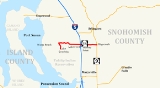
State Route 531 is a short Washington state highway
in Snohomish County
. It extends east 9.88 miles (15.9 km), from Wenberg County Park in the community of Lake Goodwin
, to SR 9 in southeast Arlington
. SR 531 intersects Interstate 5
(I-5), and passes the Arlington Airport
. The route connects I-5 to SR 9, Smokey Point
, and Wenberg County Park. The Washington State Legislature
approved SR 531's current route in 1991. Since then, construction projects, arranged by the Washington State Department of Transportation
(WSDOT), have turned this small road into an arterial street
. Even though the Washington State Legislature and WSDOT approved SR 531 in 1991, they erected no signs until April 1, 1992, when the law creating the road took effect.
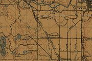
The road now used by SR 531 has existed as a separate route since at least 1911. A map dating from 1911 shows that 172nd Street, then known simply as Lakewood Road and Edgecomb Road, extended east from its current intersection with SR 9 to the banks of the South Fork Stillaguamish River
. In October 2008, WSDOT discovered a collapsed culvert
on SR 531's Cougar Creek bridge. They repaired the culvert using a hydraulic ram to insert a 24 inches (609.6 mm) diameter pipe to stabilize it. The construction, which took place on October 21 and October 24, caused traffic on SR 531 to detour
to McRae Road, 45 Road, and 11th Avenue.
(also known as Lakewood), Smokey Point
, and Edgecomb. It also passes four schools in the Lakewood School District
, as well as Weston High School in the Arlington School District
. The road intersects four major arteries: Forty-Five Road, Interstate 5
, Smokey Point Boulevard (formerly known as U.S. Route 99
), and 67th Avenue, before ending at SR 9. WSDOT found that, based on average annual daily traffic (AADT) data, about 35,000 motorists utilize the road daily at the I-5 interchange.
Starting at Wenberg County Park, the route runs north along East Lake Goodwin Road until it intersects Lakewood Road. From there, SR 531 travels east along Lakewood Road around Lake Ki before reaching Forty-Five Road. Here, Lakewood Road becomes the main artery of North Lakewood
and Smokey Point
, 172nd Street. Continuing east, SR 531 intersects 11th Avenue.
 After intersecting 11th Avenue, SR 531 becomes the northern boundary of the Lakewood High School
campus. SR 531 continues east from 11th Avenue to 16th Drive, shortly after entering Marysville
city limits. Soon thereafter, the road intersects 19th Drive, which connects the southeastern section of North Lakewood with SR 531. Continuing east across a double track
, the highway intersects 27th Avenue, which connects the road with Lakewood Crossing
, a shopping center in Lakewood. SR 531 then continues further east to the interchange with I-5.
After leaving the interchange with I-5, along with North Lakewood and Marysville city limits, SR 531 continues east to Smokey Point Boulevard (formerly U.S. Route 99) in Smokey Point. The road then maintains straight east, passing Weston High School and Arlington Municipal Airport
before intersecting 67th Avenue. From 67th Avenue, SR 531 travels east to a suburban community of Edgecomb. The road curves northeast and then southeast while on a hill. SR 531 travels east past the Arlington Gun Range and Gleneagle, a large housing area, before ending at an intersection with SR 9.
. This part of the highway has been removed.
 SR 531 became a state highway in 1991, but the highway designation did not take effect until April 1, 1992. In 2006, WSDOT announced it would complete three more projects over about five years to improve SR 531. The first, to improve the bridge and interchange between I-5 and SR 531, began immediately. The Tulalip
, Stillaguamish
, Samish
and Kikiallus Tribes helped fund the construction of the project. On April 30, 2005, the old two-lane SR 531 bridge was demolished during the night. WSDOT redirected traffic on SR 531 to the completed north side of the new bridge, while the northbound lanes of Interstate 5 were closed to all traffic and rerouted on ramps from I-5 to SR 531. During construction, eastbound SR 531 left-turn lanes were closed; a detour on Smokey Point Boulevard and SR 530 provided direct drivers access to northbound I-5. The other half of the bridge was later demolished in May 2005. All of the temporary structures on the bridge were subsequently removed in December 2005. Partly finished in June 2006, WSDOT plans to complete the project after adding a loop ramp in 2011. In August 2007, WSDOT completed a project to add sidewalks along SR 531 to the adjacent schools of the Lakewood School District.
On October 5, 2008, WSDOT discovered a collapsed culvert
on SR 531's bridge over Cougar Creek. Days later, a sinkhole formed near the bridge, prompting authorities to close the bridge for repairs. SR 531 was closed for three days, from October 21 until October 24, and drivers on SR 531 used a detour
, which went east on McRae Road, southeast on 45 Road, and north on 11th Avenue, ending at Lakewood High School
, a 4.03 miles (6.49 km) route. The cause of the collapse remains unknown, and WSDOT decided not to investigate incident. Inspectors suspect the culvert later caused a sinkhole to form. Trenchless Construction, the contractor in charge of the project, used a hydraulic ram to insert a 24 inches (609.6 mm) diameter pipe into the existing culvert, stabilizing it.
An upcoming project, adding a loop ramp onto the I-5 interchange, started in March 2009 and will end in 2011. WSDOT has awarded the contract for the project to Northwest Construction, Inc. Part of the project includes widening the main entry point to Lakewood Crossing
, by adding turn pockets. Widening SR 531 between 43rd Avenue NE and 67th Avenue NE from its current two to five lanes near the Arlington Airport
is another planned project. The project is currently in planning stages and WSDOT has set up a webpage for the project.
State highways in Washington
In the U.S. state of Washington, the Washington State Department of Transportation maintains a network of over 7000 miles of state highways, including all Interstate and U.S. Highways that pass through the state. The system comprises 8.5% of the state's public road mileage, but carries over half...
in Snohomish County
Snohomish County, Washington
Snohomish County is a county located in the U.S. state of Washington. It is named after the Snohomish tribe. Since 2000, the county's population has grown from 606,024 to 713,335 residents , making it one of the fastest-growing in the state, ranking third in overall population after King and...
. It extends east 9.88 miles (15.9 km), from Wenberg County Park in the community of Lake Goodwin
Lake Goodwin, Washington
Lake Goodwin is a census-designated place in Snohomish County, Washington, United States. The population was 3,354 at the 2000 census.Based on per capita income, one of the more reliable measures of affluence, Lake Goodwin ranks 58th of 522 areas in the state of Washington to be...
, to SR 9 in southeast Arlington
Arlington, Washington
Arlington is a city in northern Snohomish County, Washington, United States, bordered by the city of Marysville to the south. The population was 17,926 at the 2010 census.-History:...
. SR 531 intersects Interstate 5
Interstate 5 in Washington
Interstate 5 in Washington is a highway in the U.S. state of Washington that extends from its border with Oregon to its border with Canada...
(I-5), and passes the Arlington Airport
Arlington Municipal Airport (Washington)
Arlington Municipal Airport is a public airport located three miles southwest of the central business district of Arlington, a city in Snohomish County, Washington, United States. It is owned and operated by the City of Arlington.- History :...
. The route connects I-5 to SR 9, Smokey Point
Smokey Point, Washington
Smokey Point is a residential, commercial, and industrial community located in Snohomish County, Washington, USA. Formerly a census-designated place prior to the annexation of the territory inside its urban growth boundary, the northeast portion of the Smokey Point community now lies within the...
, and Wenberg County Park. The Washington State Legislature
Washington State Legislature
The Washington State Legislature is the state legislature of the U.S. state of Washington. It is a bipartisan, bicameral body, composed of the lower Washington House of Representatives, composed of 98 Representatives, and the upper Washington State Senate, with 49 Senators.The State Legislature...
approved SR 531's current route in 1991. Since then, construction projects, arranged by the Washington State Department of Transportation
Washington State Department of Transportation
The Washington State Department of Transportation , was established in 1905. The agency, led by a Secretary and overseen by the Governor, is a Washington governmental agency that constructs, maintains, and regulates the use of the state's transportation infrastructure...
(WSDOT), have turned this small road into an arterial street
Arterial road
An arterial road, or arterial thoroughfare, is a high-capacity urban road. The primary function of an arterial road is to deliver traffic from collector roads to freeways, and between urban centres at the highest level of service possible. As such, many arteries are limited-access roads, or feature...
. Even though the Washington State Legislature and WSDOT approved SR 531 in 1991, they erected no signs until April 1, 1992, when the law creating the road took effect.
The road now used by SR 531 has existed as a separate route since at least 1911. A map dating from 1911 shows that 172nd Street, then known simply as Lakewood Road and Edgecomb Road, extended east from its current intersection with SR 9 to the banks of the South Fork Stillaguamish River
Stillaguamish River
The Stillaguamish River is a river in northwest Washington in the United States. It is mainly composed of two forks, the longer North Fork Stillaguamish and the South Fork Stillaguamish. The two forks join near Arlington. From there the Stillaguamish River proper flows for to Puget Sound...
. In October 2008, WSDOT discovered a collapsed culvert
Culvert
A culvert is a device used to channel water. It may be used to allow water to pass underneath a road, railway, or embankment. Culverts can be made of many different materials; steel, polyvinyl chloride and concrete are the most common...
on SR 531's Cougar Creek bridge. They repaired the culvert using a hydraulic ram to insert a 24 inches (609.6 mm) diameter pipe to stabilize it. The construction, which took place on October 21 and October 24, caused traffic on SR 531 to detour
Detour (road)
A detour or diversion route is a route around a planned area of prohibited or reduced access, such as a construction site.Standard operating procedure for many road departments is to route any detour over roads within the same jurisdiction as the road with the obstructed area.On multi-lane highways...
to McRae Road, 45 Road, and 11th Avenue.
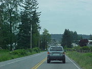
Route description
State Route 531 runs about 9.88 miles (15.9 km), from Wenberg County Park to State Route 9 south of Arlington. The route links the communities of Lake Goodwin, North LakewoodNorth Lakewood, Washington
-External links:****...
(also known as Lakewood), Smokey Point
Smokey Point, Washington
Smokey Point is a residential, commercial, and industrial community located in Snohomish County, Washington, USA. Formerly a census-designated place prior to the annexation of the territory inside its urban growth boundary, the northeast portion of the Smokey Point community now lies within the...
, and Edgecomb. It also passes four schools in the Lakewood School District
Lakewood School District (Washington)
The Lakewood School District #306 is the school district of North Lakewood, Washington, United States. The school district serves approximately 2,500 students from Warm Beach, Lake Goodwin, and Smokey Point....
, as well as Weston High School in the Arlington School District
Arlington School District
Arlington School District No. 16 is a public school district in Snohomish County, Washington and serves the city of Arlington.As of January 2011, the Arlington School District has about 5,400 students and 530 staff at 10 schools...
. The road intersects four major arteries: Forty-Five Road, Interstate 5
Interstate 5 in Washington
Interstate 5 in Washington is a highway in the U.S. state of Washington that extends from its border with Oregon to its border with Canada...
, Smokey Point Boulevard (formerly known as U.S. Route 99
U.S. Route 99
U.S. Route 99 was the main north–south highway on the West Coast of the United States until 1964, running from Calexico, California, on the U.S.-Mexico border to Blaine, Washington, on the U.S.-Canada border. It was a route of the United States Numbered Highways, assigned in 1926 and existing...
), and 67th Avenue, before ending at SR 9. WSDOT found that, based on average annual daily traffic (AADT) data, about 35,000 motorists utilize the road daily at the I-5 interchange.
Starting at Wenberg County Park, the route runs north along East Lake Goodwin Road until it intersects Lakewood Road. From there, SR 531 travels east along Lakewood Road around Lake Ki before reaching Forty-Five Road. Here, Lakewood Road becomes the main artery of North Lakewood
North Lakewood, Washington
-External links:****...
and Smokey Point
Smokey Point, Washington
Smokey Point is a residential, commercial, and industrial community located in Snohomish County, Washington, USA. Formerly a census-designated place prior to the annexation of the territory inside its urban growth boundary, the northeast portion of the Smokey Point community now lies within the...
, 172nd Street. Continuing east, SR 531 intersects 11th Avenue.
Lakewood High School (Washington)
Lakewood High School is a high school in North Lakewood, Washington, USA , owned and operated by the Lakewood School District.-History:In 1983, Lakewood Junior High School was overcrowded, so grades 9-12 moved to LHS.-Campus:...
campus. SR 531 continues east from 11th Avenue to 16th Drive, shortly after entering Marysville
Marysville, Washington
Marysville is a city in Snohomish County, Washington, United States. The population was 60,020 at the 2010 census. Marysville is known as "The Strawberry City" due to the large number of strawberry farms that once surrounded the city in its earlier days. Over the past decade, and continuing...
city limits. Soon thereafter, the road intersects 19th Drive, which connects the southeastern section of North Lakewood with SR 531. Continuing east across a double track
Double track
A double track railway usually involves running one track in each direction, compared to a single track railway where trains in both directions share the same track.- Overview :...
, the highway intersects 27th Avenue, which connects the road with Lakewood Crossing
Lakewood Crossing
Lakewood Crossing is a retail complex in the Smokey Point/Lakewood neighborhood of northern Marysville, Washington, constructed by Powell Development. It opened in September 2006 with the opening of its first tenant, Costco. As of January 2008, close to two dozen tenants have opened stores and...
, a shopping center in Lakewood. SR 531 then continues further east to the interchange with I-5.
After leaving the interchange with I-5, along with North Lakewood and Marysville city limits, SR 531 continues east to Smokey Point Boulevard (formerly U.S. Route 99) in Smokey Point. The road then maintains straight east, passing Weston High School and Arlington Municipal Airport
Arlington Municipal Airport (Washington)
Arlington Municipal Airport is a public airport located three miles southwest of the central business district of Arlington, a city in Snohomish County, Washington, United States. It is owned and operated by the City of Arlington.- History :...
before intersecting 67th Avenue. From 67th Avenue, SR 531 travels east to a suburban community of Edgecomb. The road curves northeast and then southeast while on a hill. SR 531 travels east past the Arlington Gun Range and Gleneagle, a large housing area, before ending at an intersection with SR 9.
History
The whole stretch highway from Wenberg County Park to current SR 9 has been known to exist earlier than 1911. 172nd Street NE, now SR 531, once extended from what is currently SR 9 to the banks of the South Fork Stillaguamish RiverStillaguamish River
The Stillaguamish River is a river in northwest Washington in the United States. It is mainly composed of two forks, the longer North Fork Stillaguamish and the South Fork Stillaguamish. The two forks join near Arlington. From there the Stillaguamish River proper flows for to Puget Sound...
. This part of the highway has been removed.
Tulalip
Tulalip is a group of Native American peoples from western Washington state in the United States. Today they are federally recognized as the Tulalip Tribes of the Tulalip Reservation.- History :...
, Stillaguamish
Stillaguamish (tribe)
Stillaguamish are a Native American tribe located in northwest Washington state in the United States near the city of Arlington, Washington, near the river that bears their name, the Stillaguamish River. The tribe petitioned for recognition from the United States Government in 1974, and received...
, Samish
Samish
The Samish are a Native American tribe who live in the U.S. state of Washington. The seat of their tribal government is in Anacortes. The Native American form of "Samish" is /sʔémǝš/, from /s–/, "nominalizer", /ʔé/, "be there", and /–mǝš/, "people".-Pre-Contact with Europeans:The Samish were less...
and Kikiallus Tribes helped fund the construction of the project. On April 30, 2005, the old two-lane SR 531 bridge was demolished during the night. WSDOT redirected traffic on SR 531 to the completed north side of the new bridge, while the northbound lanes of Interstate 5 were closed to all traffic and rerouted on ramps from I-5 to SR 531. During construction, eastbound SR 531 left-turn lanes were closed; a detour on Smokey Point Boulevard and SR 530 provided direct drivers access to northbound I-5. The other half of the bridge was later demolished in May 2005. All of the temporary structures on the bridge were subsequently removed in December 2005. Partly finished in June 2006, WSDOT plans to complete the project after adding a loop ramp in 2011. In August 2007, WSDOT completed a project to add sidewalks along SR 531 to the adjacent schools of the Lakewood School District.
On October 5, 2008, WSDOT discovered a collapsed culvert
Culvert
A culvert is a device used to channel water. It may be used to allow water to pass underneath a road, railway, or embankment. Culverts can be made of many different materials; steel, polyvinyl chloride and concrete are the most common...
on SR 531's bridge over Cougar Creek. Days later, a sinkhole formed near the bridge, prompting authorities to close the bridge for repairs. SR 531 was closed for three days, from October 21 until October 24, and drivers on SR 531 used a detour
Detour (road)
A detour or diversion route is a route around a planned area of prohibited or reduced access, such as a construction site.Standard operating procedure for many road departments is to route any detour over roads within the same jurisdiction as the road with the obstructed area.On multi-lane highways...
, which went east on McRae Road, southeast on 45 Road, and north on 11th Avenue, ending at Lakewood High School
Lakewood High School (Washington)
Lakewood High School is a high school in North Lakewood, Washington, USA , owned and operated by the Lakewood School District.-History:In 1983, Lakewood Junior High School was overcrowded, so grades 9-12 moved to LHS.-Campus:...
, a 4.03 miles (6.49 km) route. The cause of the collapse remains unknown, and WSDOT decided not to investigate incident. Inspectors suspect the culvert later caused a sinkhole to form. Trenchless Construction, the contractor in charge of the project, used a hydraulic ram to insert a 24 inches (609.6 mm) diameter pipe into the existing culvert, stabilizing it.
An upcoming project, adding a loop ramp onto the I-5 interchange, started in March 2009 and will end in 2011. WSDOT has awarded the contract for the project to Northwest Construction, Inc. Part of the project includes widening the main entry point to Lakewood Crossing
Lakewood Crossing
Lakewood Crossing is a retail complex in the Smokey Point/Lakewood neighborhood of northern Marysville, Washington, constructed by Powell Development. It opened in September 2006 with the opening of its first tenant, Costco. As of January 2008, close to two dozen tenants have opened stores and...
, by adding turn pockets. Widening SR 531 between 43rd Avenue NE and 67th Avenue NE from its current two to five lanes near the Arlington Airport
Arlington Municipal Airport (Washington)
Arlington Municipal Airport is a public airport located three miles southwest of the central business district of Arlington, a city in Snohomish County, Washington, United States. It is owned and operated by the City of Arlington.- History :...
is another planned project. The project is currently in planning stages and WSDOT has set up a webpage for the project.
Major intersections
External links
- Washington State Department of Transportation: 2006 overpass widening
- Washington State Department of Transportation: 2009 overpass work
- Traffic camera for SR 531 – I-5 interchange (WSDOT)
- Underneath SR 531's Cougar Creek Bridge on YoutubeYouTubeYouTube is a video-sharing website, created by three former PayPal employees in February 2005, on which users can upload, view and share videos....
from WSDOT