

Deception Pass
Encyclopedia
Deception Pass is a strait
separating Whidbey Island
from Fidalgo Island
, in the northwest part of the U.S. state
of Washington. It connects Skagit Bay
, part of Puget Sound
, with the Strait of Juan de Fuca
.
 The Deception Pass area has been home to various Coast Salish tribes for thousands of years. The first Europe
ans to see Deception Pass were members of the 1790 expedition of Manuel Quimper
on the Princesa Real. The Spanish gave it the name Boca de Flon. A group of sailors led by Joseph Whidbey
, part of the Vancouver Expedition
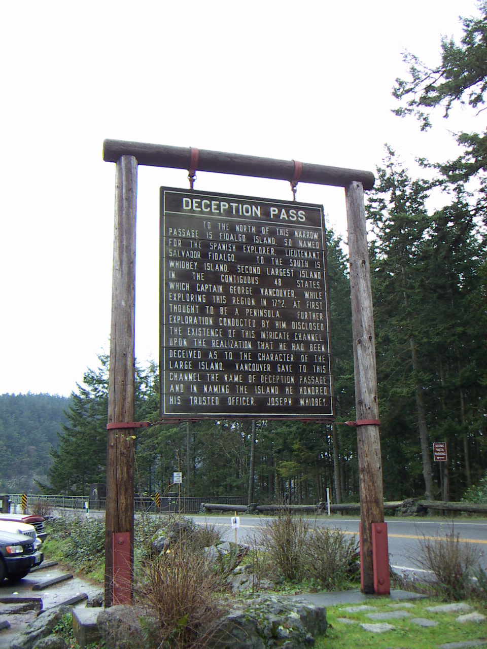
, found and mapped Deception Pass on June 7, 1792. George Vancouver
gave it the name "Deception" because it had misled him into thinking Whidbey Island was a peninsula. The "deception" was heightened due to Whidbey's failure to find the strait at first. In May 1792, Vancouver was anchored near the southern end of Whidbey Island. He sent Joseph Whidbey to explore the waters east of Whidbey Island, now known as Saratoga Passage
, using small boats. Whidbey reached the northern end of Saratoga Passage and explored eastward into Skagit Bay, which is shallow and difficult to navigate. He returned south to rejoin Vancouver without having found Deception Pass. It appeared that Skagit Bay was a dead-end and that Whidbey Island and Fidalgo Island were a long peninsula attached to the mainland. In June the expedition sailed north along the west coast of Whidbey Island. Vancouver sent Joseph Whidbey to explore inlets leading to the east. The first inlet turned out to be a "very narrow and intricate channel, which...abounded with rocks above and beneath the surface of the water". This channel led to Skagit Bay, thus separating Whidbey Island from the mainland. Vancouver apparently felt he and Joseph Whidbey had been deceived by the tricky strait. Vancouver wrote of Whidbey's efforts: "This determined [the shore they had been exploring] to be an island, which, in consequence of Mr. Whidbey’s circumnavigation, I distinguished by the name of Whidbey’s Island: and this northern pass, leading into [Skagit Bay], Deception Passage".
In the waters of Deception Pass, just east of the present-day Deception Pass Bridge, is a small island known as Ben Ure Island. The island became infamous for its activity of smuggling illegal Chinese immigrants for local labor. Ure and his partner Lawrence "Pirate" Kelly were quite profitable at their smuggling business and played hide-and-seek with the United States Customs Department for years. Ure's own operation at Deception Pass in the late 1880s consisted of Ure and his Native-American wife. Local tradition has it that his wife would camp on the nearby Strawberry Island (which was visible from the open sea) and signal him with a fire on the island's summit to alert him to whether or not it was safe to bring his illegal cargo ashore. For transport, Ure would tie the illegal immigrants up in burlap bags so that if customs agents were to approach then he could easily toss the bags overboard. The tidal currents would carry the discarded immigrants' bodies to San Juan Island
to the north and west of the pass and many ended up in what became known as Dead Man's Bay.
 Between the years 1910 and 1914, a prison rock quarry was operated on the Fidalgo Island side of the pass. Nearby barracks housed some 40 prisoners, members of an honors program out of Walla Walla State Penitentiary and the prison population was made up of several types of prisoners, including those convicted of murder. Guards stood watch at the quarry as the prisoners cut the rock into gravel and loaded it onto barges located at the base of the cliff atop the pass's waters. The quarried rock was then taken by barge to the Seattle waterfront. The camp was dismantled in 1924 and although abandoned as a quarry, the remains of the camp can still be found. The location, however, is hazardous and over the years there have been several fatal accidents when visitors have ventured onto the steep cliffs.
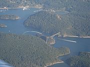
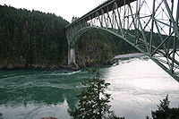
Upon completion on July 31, 1935, the 976 feet (297.5 m) span Deception Pass Bridge
connected Whidbey Island to the tiny Pass Island, and Pass Island to Fidalgo Island
. Prior to the bridge, travellers and businessmen would use an inter-island ferry to commute between Fidalgo and Whidbey islands.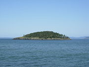 Deception Pass is a dramatic seascape where the tidal flow and whirlpools beneath the twin bridges connecting Fidalgo Island to Whidbey Island move quickly. During low tides, the swift current can lead to standing waves, large whirlpools, and roiling eddies. This swift current phenomenon can be viewed from the twin bridges' pedestrian walkways or from the trail leading below the larger south bridge from the parking lot on the Whidbey Island side. Boats can be seen waiting on either side of the pass for the current to stop or change direction before going through. Thrill-seeking kayakers go there during large tide changes to surf the standing waves and brave the class 2 and 3 rapid conditions.
 Deception Pass is today surrounded by Deception Pass State Park, the most-visited park in Washington with over 2 million visitors each year. The park was officially established in 1923, when the original 1600 acres (6.5 km²) of a military reserve was transferred to Washington State Parks. The park's facilities were greatly enhanced in the 1930s when the Civilian Conservation Corps
(CCC) built roads, trails, and buildings in order to develop the park.
The road to West Beach was created in 1950, opening up a beautiful stretch of beach to hordes of vehicles. The former fish hatchery at Bowman Bay became a part of the park in the early Seventies. The old entrance to the park was closed in 1997 when a new entrance was created at the intersection of Highway 20 and Cornet Bay road, improving access into and out of the park.
Deception Pass State Park has an amazing abundance of recreational opportunities. It has three campgrounds. The Cranberry campground is the largest, with 235 sites, along the shores of Cranberry Lake and North Beach. Many of these sites are in old growth forest. Quarry Pond campground is east of Highway 20, with 61 sites, mostly hookup sites. It serves as the wintertime campground. Across the bridge at Bowman Bay is the small and intimate Bowman campground, with only 20 sites, only two of which have power and water. The others, close to the bay, are non-power sites. The campsites are all reservable, and fill up quickly for the summer. Reservations at least several months in advance are recommended.
Hiking around the park is a joyous experience, although there are no long trails. Popular hikes include Goose Rock, offering views over much of the park; Lighthouse Point, with views over the strait and back to the bridge; the dunes trail at West Beach; and Rosario Head. Other lesser known hikes include the Pass Lake loop trail and the Hoypus Point trails complex. Bicycles and horses are allowed only on some of the trails, not at Goose Rock or Hoypus Point.
The beaches are a delight to explore. West Beach is the most popular, with a parking lot for over 200 cars perched right on the shoulder of the beach. North Beach nearby offers a mile of wilderness beach with views of the bridge above. Bowman Bay is a quiet refuge, although popular for kids with a big toy playground, and for kayakers. Rosario Beach is a wilder beach.
Rosario also has tidepools for exploring. There is a trail through the tidepools with a rope to show you where the trail is. Volunteers help visitors learn about the plants and animals in the tidepools. The life is coming back because people are respecting the trail and not trampling (or removing!) intertidal life.
The Cornet Bay Retreat Center has cabins for up to 180 people, and a recreation hall and dining hall with full kitchen facilities.
Cornet Bay is a busy boat launch facility, with six saltwater ramps for launching boats, moorage docks for overnight use, and ample parking. Crabbing and fishing are popular here as well.
Bowman Bay has an interpretive center that explains the story of the CCC throughout Washington state. Near the center is a statue honoring the men of the CCC, Washington state's location for this statue which has been placed in over 30 states now.
Pass Lake, on the north side of the bridge, is a fly-fishing only lake, catch and release required. Fishing in the waters of Cranberry Lake is popular for trout. The saltwater is famous for ling cod, salmon, crabs, shrimp, and other fisheries. Salmon can even be caught from the beach during the peak season.
Several concessions offer special recreational opportunities. Food services are available at West Beach during the busy season, along with canoe and paddle boat rentals. Kayaks may be rented for guided tours out of Bowman Bay. And Deception Pass Tours offers boat tours under the bridge and out into the straits, every hour on the hour, from Cornet Bay, again during the busier months of the year.
The bridge is perhaps the biggest attraction of the park, as it rises 180 feet (54.9 m) above the water, with walkways on both sides of the highway. Parking is available at the north, south, and mid-span Pass Island areas.
Ten islands are also a part of the state park, including Northwest Island, Deception Island, Pass Island, Strawberry, Ben Ure, Kiket, Skagit, Hope, and Big and Little Deadman Islands. Ben Ure Island has a small cabin available for rent for just two people. A human-powered boat is required to get to the cabin.
was in part filmed near the pass.
Seattle shoegaze
act The Sight Below
filmed the 2008 video for their track Further Away at Deception Pass, with Deception Island's scenic imagery prominently featured.
Seattle grunge
band Mudhoney
named a song on their 1993 EP Five Dollar Bob's Mock Cooter Stew
"Deception Pass."
Strait
A strait or straits is a narrow, typically navigable channel of water that connects two larger, navigable bodies of water. It most commonly refers to a channel of water that lies between two land masses, but it may also refer to a navigable channel through a body of water that is otherwise not...
separating Whidbey Island
Whidbey Island
Whidbey Island is one of nine islands located in Island County, Washington, in the United States. Whidbey is located about north of Seattle, and lies between the Olympic Peninsula and the I-5 corridor of western Washington...
from Fidalgo Island
Fidalgo Island
Fidalgo Island is an island in Skagit County, Washington, located about north of Seattle. To the east, it is separated from the mainland by the Swinomish Channel, and from Whidbey Island to the south by Deception Pass...
, in the northwest part of the U.S. state
U.S. state
A U.S. state is any one of the 50 federated states of the United States of America that share sovereignty with the federal government. Because of this shared sovereignty, an American is a citizen both of the federal entity and of his or her state of domicile. Four states use the official title of...
of Washington. It connects Skagit Bay
Skagit Bay
Skagit Bay is a bay and strait located in the U.S. state of Washington. It is part of the Whidbey Island Basin of Puget Sound. The Skagit River empties into Skagit Bay. To the south, Skagit Bay connects with the rest of Puget Sound via Saratoga Passage and Possession Sound...
, part of Puget Sound
Puget Sound
Puget Sound is a sound in the U.S. state of Washington. It is a complex estuarine system of interconnected marine waterways and basins, with one major and one minor connection to the Strait of Juan de Fuca and the Pacific Ocean — Admiralty Inlet being the major connection and...
, with the Strait of Juan de Fuca
Strait of Juan de Fuca
The Strait of Juan de Fuca is a large body of water about long that is the Salish Sea outlet to the Pacific Ocean...
.
History
Europe
Europe is, by convention, one of the world's seven continents. Comprising the westernmost peninsula of Eurasia, Europe is generally 'divided' from Asia to its east by the watershed divides of the Ural and Caucasus Mountains, the Ural River, the Caspian and Black Seas, and the waterways connecting...
ans to see Deception Pass were members of the 1790 expedition of Manuel Quimper
Manuel Quimper
Manuel Quimper Benítez del Pino was a Spanish Peruvian explorer, cartographer, naval officer, and colonial official. He participated in charting the Strait of Juan de Fuca and the Sandwich Islands in the late 18th century. He was later appointed a colonial governor in his native Peru at the...
on the Princesa Real. The Spanish gave it the name Boca de Flon. A group of sailors led by Joseph Whidbey
Joseph Whidbey
Joseph Whidbey was a member of the Royal Navy who served on the Vancouver Expedition 1791–1795, and later achieved renown as a naval engineer. He is notable for having been the first European to discover and chart Admiralty Island in the Alexander Archipelago in 1794.Little is recorded of...
, part of the Vancouver Expedition
Vancouver Expedition
The Vancouver Expedition was a four-and-a-half-year voyage of exploration and diplomacy, commanded by Captain George Vancouver. The expedition circumnavigated the globe, touched five continents and changed the course of history for the indigenous nations and several European empires and their...
, found and mapped Deception Pass on June 7, 1792. George Vancouver
George Vancouver
Captain George Vancouver RN was an English officer of the British Royal Navy, best known for his 1791-95 expedition, which explored and charted North America's northwestern Pacific Coast regions, including the coasts of contemporary Alaska, British Columbia, Washington and Oregon...
gave it the name "Deception" because it had misled him into thinking Whidbey Island was a peninsula. The "deception" was heightened due to Whidbey's failure to find the strait at first. In May 1792, Vancouver was anchored near the southern end of Whidbey Island. He sent Joseph Whidbey to explore the waters east of Whidbey Island, now known as Saratoga Passage
Saratoga Passage
Saratoga Passage lies in Puget Sound between Whidbey Island and Camano Island.Saratoga Passage extends about 18 miles in a northwesterly direction from its entrance between Sandy Point on the Whidbey Island side and Camano Head on the other. At its northern end, Saratoga Passage connects with Penn...
, using small boats. Whidbey reached the northern end of Saratoga Passage and explored eastward into Skagit Bay, which is shallow and difficult to navigate. He returned south to rejoin Vancouver without having found Deception Pass. It appeared that Skagit Bay was a dead-end and that Whidbey Island and Fidalgo Island were a long peninsula attached to the mainland. In June the expedition sailed north along the west coast of Whidbey Island. Vancouver sent Joseph Whidbey to explore inlets leading to the east. The first inlet turned out to be a "very narrow and intricate channel, which...abounded with rocks above and beneath the surface of the water". This channel led to Skagit Bay, thus separating Whidbey Island from the mainland. Vancouver apparently felt he and Joseph Whidbey had been deceived by the tricky strait. Vancouver wrote of Whidbey's efforts: "This determined [the shore they had been exploring] to be an island, which, in consequence of Mr. Whidbey’s circumnavigation, I distinguished by the name of Whidbey’s Island: and this northern pass, leading into [Skagit Bay], Deception Passage".
In the waters of Deception Pass, just east of the present-day Deception Pass Bridge, is a small island known as Ben Ure Island. The island became infamous for its activity of smuggling illegal Chinese immigrants for local labor. Ure and his partner Lawrence "Pirate" Kelly were quite profitable at their smuggling business and played hide-and-seek with the United States Customs Department for years. Ure's own operation at Deception Pass in the late 1880s consisted of Ure and his Native-American wife. Local tradition has it that his wife would camp on the nearby Strawberry Island (which was visible from the open sea) and signal him with a fire on the island's summit to alert him to whether or not it was safe to bring his illegal cargo ashore. For transport, Ure would tie the illegal immigrants up in burlap bags so that if customs agents were to approach then he could easily toss the bags overboard. The tidal currents would carry the discarded immigrants' bodies to San Juan Island
San Juan Island
San Juan Island is the second-largest and most populous of the San Juan Islands in northwestern Washington, United States. It has a land area of 142.59 km² and a population of 6,822 as of the 2000 census....
to the north and west of the pass and many ended up in what became known as Dead Man's Bay.
Upon completion on July 31, 1935, the 976 feet (297.5 m) span Deception Pass Bridge
Deception Pass Bridge
The Deception Pass Bridge is a two-lane bridge connecting Whidbey Island to Fidalgo Island in the U.S. state of Washington. It was a Washington State Highways project, and included project elements built by young workers from the Civilian Conservation Corps...
connected Whidbey Island to the tiny Pass Island, and Pass Island to Fidalgo Island
Fidalgo Island
Fidalgo Island is an island in Skagit County, Washington, located about north of Seattle. To the east, it is separated from the mainland by the Swinomish Channel, and from Whidbey Island to the south by Deception Pass...
. Prior to the bridge, travellers and businessmen would use an inter-island ferry to commute between Fidalgo and Whidbey islands.
History and Recreation
Civilian Conservation Corps
The Civilian Conservation Corps was a public work relief program that operated from 1933 to 1942 in the United States for unemployed, unmarried men from relief families, ages 18–25. A part of the New Deal of President Franklin D...
(CCC) built roads, trails, and buildings in order to develop the park.
The road to West Beach was created in 1950, opening up a beautiful stretch of beach to hordes of vehicles. The former fish hatchery at Bowman Bay became a part of the park in the early Seventies. The old entrance to the park was closed in 1997 when a new entrance was created at the intersection of Highway 20 and Cornet Bay road, improving access into and out of the park.
Deception Pass State Park has an amazing abundance of recreational opportunities. It has three campgrounds. The Cranberry campground is the largest, with 235 sites, along the shores of Cranberry Lake and North Beach. Many of these sites are in old growth forest. Quarry Pond campground is east of Highway 20, with 61 sites, mostly hookup sites. It serves as the wintertime campground. Across the bridge at Bowman Bay is the small and intimate Bowman campground, with only 20 sites, only two of which have power and water. The others, close to the bay, are non-power sites. The campsites are all reservable, and fill up quickly for the summer. Reservations at least several months in advance are recommended.
Hiking around the park is a joyous experience, although there are no long trails. Popular hikes include Goose Rock, offering views over much of the park; Lighthouse Point, with views over the strait and back to the bridge; the dunes trail at West Beach; and Rosario Head. Other lesser known hikes include the Pass Lake loop trail and the Hoypus Point trails complex. Bicycles and horses are allowed only on some of the trails, not at Goose Rock or Hoypus Point.
The beaches are a delight to explore. West Beach is the most popular, with a parking lot for over 200 cars perched right on the shoulder of the beach. North Beach nearby offers a mile of wilderness beach with views of the bridge above. Bowman Bay is a quiet refuge, although popular for kids with a big toy playground, and for kayakers. Rosario Beach is a wilder beach.
Rosario also has tidepools for exploring. There is a trail through the tidepools with a rope to show you where the trail is. Volunteers help visitors learn about the plants and animals in the tidepools. The life is coming back because people are respecting the trail and not trampling (or removing!) intertidal life.
The Cornet Bay Retreat Center has cabins for up to 180 people, and a recreation hall and dining hall with full kitchen facilities.
Cornet Bay is a busy boat launch facility, with six saltwater ramps for launching boats, moorage docks for overnight use, and ample parking. Crabbing and fishing are popular here as well.
Bowman Bay has an interpretive center that explains the story of the CCC throughout Washington state. Near the center is a statue honoring the men of the CCC, Washington state's location for this statue which has been placed in over 30 states now.
Pass Lake, on the north side of the bridge, is a fly-fishing only lake, catch and release required. Fishing in the waters of Cranberry Lake is popular for trout. The saltwater is famous for ling cod, salmon, crabs, shrimp, and other fisheries. Salmon can even be caught from the beach during the peak season.
Several concessions offer special recreational opportunities. Food services are available at West Beach during the busy season, along with canoe and paddle boat rentals. Kayaks may be rented for guided tours out of Bowman Bay. And Deception Pass Tours offers boat tours under the bridge and out into the straits, every hour on the hour, from Cornet Bay, again during the busier months of the year.
The bridge is perhaps the biggest attraction of the park, as it rises 180 feet (54.9 m) above the water, with walkways on both sides of the highway. Parking is available at the north, south, and mid-span Pass Island areas.
Ten islands are also a part of the state park, including Northwest Island, Deception Island, Pass Island, Strawberry, Ben Ure, Kiket, Skagit, Hope, and Big and Little Deadman Islands. Ben Ure Island has a small cabin available for rent for just two people. A human-powered boat is required to get to the cabin.
Trivia
The 2002 horror movie The RingThe Ring (2002 film)
The Ring is a 2002 American psychological horror film directed by Gore Verbinski and starring Naomi Watts and Martin Henderson. It is a remake of the 1998 Japanese horror film Ring....
was in part filmed near the pass.
Seattle shoegaze
Shoegazing
Shoegazing is a subgenre of alternative rock that emerged from the United Kingdom in the late 1980s. It lasted there until the mid 1990s, with a critical zenith reached in 1990 and 1991...
act The Sight Below
The Sight Below
The Sight Below is an electronic music/shoegaze act from Seattle, Washington. Its main member is American post-minimalist composer Rafael Anton Irisarri....
filmed the 2008 video for their track Further Away at Deception Pass, with Deception Island's scenic imagery prominently featured.
Seattle grunge
Grunge
Grunge is a subgenre of alternative rock that emerged during the mid-1980s in the American state of Washington, particularly in the Seattle area. Inspired by hardcore punk, heavy metal, and indie rock, grunge is generally characterized by heavily distorted electric guitars, contrasting song...
band Mudhoney
Mudhoney
Mudhoney is an American alternative rock band. Formed in Seattle, Washington, in 1988 following the demise of Green River, Mudhoney's members are vocalist and rhythm guitarist Mark Arm, lead guitarist Steve Turner, bassist Guy Maddison, and drummer Dan Peters. Original bassist Matt Lukin left the...
named a song on their 1993 EP Five Dollar Bob's Mock Cooter Stew
Five Dollar Bob's Mock Cooter Stew
Five Dollar Bob's Mock Cooter Stew is an EP by the grunge band Mudhoney released on October 26, 1993 by Reprise Records. Mudhoney vocalist Mark Arm described this EP as a chance for the band to "get new songs out for fans in between albums."...
"Deception Pass."