
Stillaguamish River
Encyclopedia
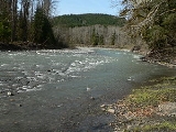
The Stillaguamish River is a river in northwest Washington in the United States
. It is mainly composed of two forks, the longer North Fork Stillaguamish (45 miles (72 km)) and the South Fork Stillaguamish. The two forks join near Arlington
. From there the Stillaguamish River proper flows for 22 miles (35 km) to Puget Sound
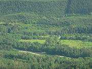
. The river's watershed drains part of the Cascade Range
north of Seattle
.
 The Stillaguamish River is formed from the confluence of the North and South Forks, both of which rise in the Cascades. The North Fork rises as several branches in a remote area of Skagit County
near Finney Peak, approximately 10 miles (16 km) north of Darrington
. Collecting many tributary creeks, the river flows south, then west through the foothills along the Skagit-Snohomish
county line. Tributaries of the North Fork Stillaguamish River include Boulder River
and Deer Creek.
The South Fork (30 miles (48 km)) rises near in central Snohomish County, 20 miles (32 km) south of Darrington, and flows west and northwest by Silverton, Verlot
, and Granite Falls
.
The two forks unite at Arlington
in northwestern Snohomish County. The combined stream flows west, entering the north end of Port Susan
, an arm of Puget Sound, approximately 10 miles (16 km) west of Arlington. Between the North and South Forks there is a portion of the Mount Baker-Snoqualmie National Forest
called the Boulder River Wilderness
.
United States
The United States of America is a federal constitutional republic comprising fifty states and a federal district...
. It is mainly composed of two forks, the longer North Fork Stillaguamish (45 miles (72 km)) and the South Fork Stillaguamish. The two forks join near Arlington
Arlington, Washington
Arlington is a city in northern Snohomish County, Washington, United States, bordered by the city of Marysville to the south. The population was 17,926 at the 2010 census.-History:...
. From there the Stillaguamish River proper flows for 22 miles (35 km) to Puget Sound
Puget Sound
Puget Sound is a sound in the U.S. state of Washington. It is a complex estuarine system of interconnected marine waterways and basins, with one major and one minor connection to the Strait of Juan de Fuca and the Pacific Ocean — Admiralty Inlet being the major connection and...
. The river's watershed drains part of the Cascade Range
Cascade Range
The Cascade Range is a major mountain range of western North America, extending from southern British Columbia through Washington and Oregon to Northern California. It includes both non-volcanic mountains, such as the North Cascades, and the notable volcanoes known as the High Cascades...
north of Seattle
Seattle, Washington
Seattle is the county seat of King County, Washington. With 608,660 residents as of the 2010 Census, Seattle is the largest city in the Northwestern United States. The Seattle metropolitan area of about 3.4 million inhabitants is the 15th largest metropolitan area in the country...
.
Course
Skagit County, Washington
Skagit County is a county in the U.S. state of Washington. It is named after the Skagit Indian tribe. As of 2010, the population was 116,901. It is included in the Mount Vernon-Anacortes, Washington, Metropolitan Statistical Area...
near Finney Peak, approximately 10 miles (16 km) north of Darrington
Darrington, Washington
Darrington is a town in Snohomish County, Washington, United States. The population was 1,347 at the 2010 census.-History:The upper Stillaguamish valley where Darrington is located was once settled by the local Sauk-Suiattle Tribes in the drainage of the Sauk, Suiattle and Whitechuck rivers...
. Collecting many tributary creeks, the river flows south, then west through the foothills along the Skagit-Snohomish
Snohomish County, Washington
Snohomish County is a county located in the U.S. state of Washington. It is named after the Snohomish tribe. Since 2000, the county's population has grown from 606,024 to 713,335 residents , making it one of the fastest-growing in the state, ranking third in overall population after King and...
county line. Tributaries of the North Fork Stillaguamish River include Boulder River
Boulder River (Washington)
The Boulder River is a river in the U.S. state of Washington.-Course:The Boulder River originates in the Cascade Range. It flows northwest and then northeast through a portion of Boulder River Wilderness to join the Stillaguamish River. The Stillaguamish empties into Port Susan, part of Puget Sound...
and Deer Creek.
The South Fork (30 miles (48 km)) rises near in central Snohomish County, 20 miles (32 km) south of Darrington, and flows west and northwest by Silverton, Verlot
Verlot, Washington
Verlot is a census-designated place in Snohomish County, Washington, United States. The population was 285 at the 2010 census.-Geography:Verlot is located at ....
, and Granite Falls
Granite Falls, Washington
Granite Falls is a city in Snohomish County, Washington, United States. The population was 3,364 at the 2010 census.-History:Before the arrival of European settlers, the area that is now Granite Falls was used by Native Americans to portage their canoes between fishing grounds.The first permanent...
.
The two forks unite at Arlington
Arlington, Washington
Arlington is a city in northern Snohomish County, Washington, United States, bordered by the city of Marysville to the south. The population was 17,926 at the 2010 census.-History:...
in northwestern Snohomish County. The combined stream flows west, entering the north end of Port Susan
Port Susan
Port Susan is a bay and strait located in the U.S. state of Washington. Part of the Whidbey Island Basin of Puget Sound, Port Susan is bounded by Camano Island to the west and the mainland to the east. The Stillaguamish River empties into the northern end of Port Susan. To the south, Port Susan...
, an arm of Puget Sound, approximately 10 miles (16 km) west of Arlington. Between the North and South Forks there is a portion of the Mount Baker-Snoqualmie National Forest
Mount Baker-Snoqualmie National Forest
The Mount Baker-Snoqualmie National Forest in Washington extends more than along the western slopes of the Cascade Range from the Canadian border to the northern boundary of Mount Rainier National Park. Forest headquarters are located in the city of Everett....
called the Boulder River Wilderness
Boulder River Wilderness
Boulder River Wilderness is a wilderness area within the Mount Baker-Snoqualmie National Forest in the western Cascade Range of Washington state.-Topography:...
.