

Ghost town
Encyclopedia
Town
A town is a human settlement larger than a village but smaller than a city. The size a settlement must be in order to be called a "town" varies considerably in different parts of the world, so that, for example, many American "small towns" seem to British people to be no more than villages, while...
or city
City
A city is a relatively large and permanent settlement. Although there is no agreement on how a city is distinguished from a town within general English language meanings, many cities have a particular administrative, legal, or historical status based on local law.For example, in the U.S...
. A town often becomes a ghost town because the economic activity that supported it has failed, or due to natural or human-caused disasters such as floods, government actions, uncontrolled lawlessness, war, or nuclear disasters. The term is sometimes used to refer to cities, towns, and neighborhoods which are still populated, but significantly less so than in years past.
Some ghost towns are tourist attractions: Barkerville, British Columbia
Barkerville, British Columbia
Barkerville was the main town of the Cariboo Gold Rush in British Columbia, Canada and is preserved as a historic town. It is located on the north slope of the Cariboo Plateau near the Cariboo Mountains east of Quesnel along BC Highway 26, which follows the route of the original access to...
; Bannack, Montana
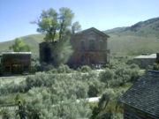
Bannack, Montana
Bannack is a ghost town in Beaverhead County, Montana, United States, located on Grasshopper Creek, approximately upstream from where Grasshopper Creek joins with the Beaverhead River south of Dillon.-History:...
; Elizabeth Bay, Namibia
Elizabeth Bay (Namibian ghost town)
Elizabeth Bay is a mining town in southern Namibia. It was formerly considered a ghost town.Elizabeth Bay in on the coast of Namibia, 25 km south of Lüderitz....
; Pripyat, Ukraine, Kolmanskop, Namibia
Kolmanskop
Kolmanskop is a ghost town in the Namib desert in southern Namibia, a few kilometres inland from the port town of Lüderitz. It was named after a transport driver named Johnny Coleman who, during a sand storm, abandoned his ox wagon on a small incline opposite the settlement...
; and Oatman, Arizona
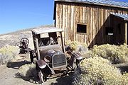
Oatman, Arizona
Oatman is a former mining town in the Black Mountains of Mohave County, Arizona, United States. Located at an elevation of , it began as a tent camp soon after two prospectors struck a $10 million gold find in 1915, though the area had been already settled for a number of years. Oatman's...
; among them. This is especially true of those that preserve period-specific architecture. Visiting, writing about, and photographing ghost towns is a minor industry.
Proposed characteristics of a ghost town
Tarleton State University
Tarleton State University is a public, coeducational, state university located in Stephenville, Texas. It is the largest non-land-grant university primarily devoted to agriculture in the United States....
in Stephenville, Texas and has researched many ghost towns throughout Texas, recording his findings in the books Ghost Towns of Texas and More Ghost Towns of Texas. Baker has proposed a short set of guidelines that he uses to distinguish a genuine ghost town from a dispersed rural community or a vanished or phantom settlement:
The town's reason for being must no longer exist. Although abandoned sites clearly meet this requirement, this does not exclude certain semi-abandoned sites from being classified as ghost towns, provided they maintain only a skeleton population.
There must be tangible remains of the town for visitors to see. These can range from a dilapidated main street populated with abandoned mercantile/government buildings to only a town cemetery (Baker also stipulated that townsites included in his own books must have public access and be evenly distributed throughout Texas).
Reasons for abandonment
Factors leading to abandonment of towns include depleted natural resources, economic activity shifting elsewhere, railroads and roads bypassing or no longer accessing the town, human intervention, disasters, massacres, and the shifting of politics or fall of empires.Depleted natural resources
Ghost towns may result when the single activity or resource that created a boomtownBoomtown
A boomtown is a community that experiences sudden and rapid population and economic growth. The growth is normally attributed to the nearby discovery of a precious resource such as gold, silver, or oil, although the term can also be applied to communities growing very rapidly for different reasons,...
(e.g., nearby mine, mill or resort) is depleted or the resource economy undergoes a “bust” (e.g., catastrophic resource price collapse). Boomtowns can often decrease in size as fast as they initially grew. Sometimes, all or nearly the entire population can desert the town, resulting in a ghost town.
Economic activity shifting elsewhere
The dismantling of a boomtown can often occur on a planned basis. Mining companies nowadays will create a temporary community to service a mine-site, building all the accommodation shops and services, and then remove it as the resource is worked out.Human intervention
Railroads and roads bypassing or no longer accessing a town can create a ghost town. This was the case in many of the ghost towns along Ontario's historic Opeongo Line, and along U.S. Route 66U.S. Route 66
U.S. Route 66 was a highway within the U.S. Highway System. One of the original U.S. highways, Route 66 was established on November 11, 1926 -- with road signs erected the following year...
after motorists bypassed the latter on the faster moving highways I-44 and I-40.
River re-routing is another factor, one example being the towns along the Aral Sea
Aral Sea
The Aral Sea was a lake that lay between Kazakhstan in the north and Karakalpakstan, an autonomous region of Uzbekistan, in the south...
.
Ghost towns may be created when land is expropriated
Eminent domain
Eminent domain , compulsory purchase , resumption/compulsory acquisition , or expropriation is an action of the state to seize a citizen's private property, expropriate property, or seize a citizen's rights in property with due monetary compensation, but without the owner's consent...
by a government and residents are required to relocate. An excellent example is the village of Tyneham
Tyneham
Tyneham is a ghost village in south Dorset, England, near Lulworth on the Isle of Purbeck. It remains a civil parish.-Location:The village is situated northeast of Worbarrow Bay on the Jurassic Coast, about south of Wareham and about west of Swanage. It is part of the Lulworth Estate. Tyneham is...
in Dorset
Dorset
Dorset , is a county in South West England on the English Channel coast. The county town is Dorchester which is situated in the south. The Hampshire towns of Bournemouth and Christchurch joined the county with the reorganisation of local government in 1974...
, England, acquired during World War II to build an artillery range. Another example is when NASA
NASA
The National Aeronautics and Space Administration is the agency of the United States government that is responsible for the nation's civilian space program and for aeronautics and aerospace research...
acquired land to build a rocket propulsion testing center. Construction of the John C. Stennis Space Center
John C. Stennis Space Center
The John C. Stennis Space Center , located in Hancock County, Mississippi, at the Mississippi-Louisiana border, is NASA's largest rocket engine test facility.- History :...
in Mississippi
Mississippi
Mississippi is a U.S. state located in the Southern United States. Jackson is the state capital and largest city. The name of the state derives from the Mississippi River, which flows along its western boundary, whose name comes from the Ojibwe word misi-ziibi...
, U.S., required acquisition of a large buffer zone
Buffer zone
A buffer zone is generally a zonal area that lies between two or more other areas , but depending on the type of buffer zone, the reason for it may be to segregate regions or to conjoin them....
(approximately 34 square miles) because of the loud noise and potential dangers associated with testing huge rockets. Communities were abandoned and roads became overgrown with forest flora.
Sometimes, the town might cease to officially exist, but the physical infrastructure remains. One example of this is the former town of Weston, Illinois, which voted itself out of existence and turned the land over for construction of the Fermi National Accelerator Laboratory. Many houses and even a few barns remain, used for housing visiting scientists and storing maintenance equipment, while roads that used to cross through the site have been blocked off at the edges of the property, with gatehouses or simply barricades to prevent unsupervised access.
Construction of dams has produced ghost towns left underwater. Examples include the settlement of Loyston, Tennessee
Loyston, Tennessee
Loyston was a community in Union County, Tennessee, USA, that was inundated by the waters of Norris Lake after the completion of Norris Dam in 1935. Established in the early 19th century around a foundry built by its namesake, John Loy, over subsequent decades the community's location along State...
, U.S., inundated by the creation of Norris Dam
Norris Dam
Norris Dam is a hydroelectric and flood control structure located on the Clinch River in Anderson County and Campbell County, Tennessee, USA. Its construction in the mid-1930s was the first major project for the Tennessee Valley Authority, which had been created in 1933 to bring economic...
. The town was reorganised and reconstructed on nearby higher ground. Other examples are The Lost Villages
The Lost Villages
The Lost Villages are ten communities in the Canadian province of Ontario, in the former townships of Cornwall and Osnabruck near Cornwall, which were permanently submerged by the creation of the Saint Lawrence Seaway in 1958....
of Ontario
Ontario
Ontario is a province of Canada, located in east-central Canada. It is Canada's most populous province and second largest in total area. It is home to the nation's most populous city, Toronto, and the nation's capital, Ottawa....
, the hamlets of Nether Hambleton and Middle Hambleton in Rutland
Rutland
Rutland is a landlocked county in central England, bounded on the west and north by Leicestershire, northeast by Lincolnshire and southeast by Peterborough and Northamptonshire....
, England, which were flooded to create Rutland Water
Rutland Water
Rutland Water is Anglian Water's drinking water reservoir in the county of Rutland, England, just east of the county town Oakham. It was known as Empingham Reservoir during its construction and until its official opening in 1976. The centre of its dam is at British national grid reference...
, Europe's largest man-made reservoir, and the villages of Ashopton
Ashopton
Ashopton was a village in Derbyshire, England, that was lost along with neighbouring Derwent when the Ladybower Reservoir was constructed in the late 1930s and early 1940s....
and Derwent
Derwent, Derbyshire
Derwent is a village 'drowned' under the Ladybower Reservoir in Derbyshire, England. The village of Ashopton, Derwent Woodlands church and Derwent Hall were also 'drowned' in the construction of the reservoir. There is no formal memorial to any of the villages...
, England, flooded during the construction of the Ladybower Reservoir
Ladybower Reservoir
Ladybower Reservoir is a large Y-shaped reservoir, the lowest of three in the Upper Derwent Valley in Derbyshire, England. The River Ashop flows into the reservoir from the west; the River Derwent flows south, initially through Howden Reservoir, then Derwent Reservoir, and finally through Ladybower...
. Mologa
Mologa
Mologa was a town in Yaroslavl Oblast, Russia, formerly situated at the confluence of Mologa and Volga Rivers, but now submerged under the waters of the Rybinsk Reservoir....
in Russia was flooded by the creation of Rybinsk reservoir
Rybinsk Reservoir
Rybinsk Reservoir , informally called the Rybinsk Sea, is a water reservoir on the Volga River and its tributaries Sheksna and Mologa, formed by Rybinsk Hydroelectric Station dam, located on the territories of Tver, Vologda, and Yaroslavl Oblasts. At the time of its construction, it was the largest...
. Many ancient villages had to be abandoned during construction of the Three Gorges Dam
Three Gorges Dam
The Three Gorges Dam is a hydroelectric dam that spans the Yangtze River by the town of Sandouping, located in the Yiling District of Yichang, in Hubei province, China...
in China, leading to displacement of many rural people. In the Costa Rican province of Guanacaste, the town of Arenal
Lake Arenal
Lake Arenal is an artificial lake in Costa Rica, located in the northern highlands of the country. It was enlarged to its present size as a part of a 1979 hydroelectric project by the Costa Rican government to provide electricity to the country.- Geography :...
was rebuilt to make room for the man-made Lake Arenal
Lake Arenal
Lake Arenal is an artificial lake in Costa Rica, located in the northern highlands of the country. It was enlarged to its present size as a part of a 1979 hydroelectric project by the Costa Rican government to provide electricity to the country.- Geography :...
. The old town now lies submerged below the lake.
Epidemics
Significant fatality rates from epidemics have produced ghost towns. For example, some places in eastern ArkansasArkansas
Arkansas is a state located in the southern region of the United States. Its name is an Algonquian name of the Quapaw Indians. Arkansas shares borders with six states , and its eastern border is largely defined by the Mississippi River...
were abandoned after over 7,000 Arkansans died during the Spanish Flu
Spanish flu
The 1918 flu pandemic was an influenza pandemic, and the first of the two pandemics involving H1N1 influenza virus . It was an unusually severe and deadly pandemic that spread across the world. Historical and epidemiological data are inadequate to identify the geographic origin...
epidemic of 1918 and 1919.
Disasters, actual and anticipated
Natural and man-made disasters can create ghost towns. For example, after being flooded more than 30 times since their town was founded in 1845, residents of Pattonsburg, MissouriPattonsburg, Missouri
Pattonsburg is a city in Daviess County, Missouri, United States. The population was 261 at the 2000 census.-Geography:Pattonsburg is located at ....
, had enough after two floods in 1993. With government help, the whole town was rebuilt 3 miles (4.8 km) away.
Ghost towns may also occasionally come into being due to an anticipated natural disaster – for example, the Canadian town of Lemieux, Ontario
Lemieux, Ontario
Lemieux is a ghost town in the Canadian province of Ontario, which was located on the shore of the South Nation River in the Prescott and Russell County township of South Plantagenet...
was abandoned in 1991 after soil testing revealed that the community was built on an unstable bed of Leda clay. Two years after the last building in Lemieux was demolished, a landslide swept part of the former townsite into the South Nation River
South Nation River
The South Nation River is a river in Eastern Ontario, Canada. It springs from forests and marshes located north of Brockville and it flows 175 km northeast to empty into the Ottawa River north of Plantagenet...
.
The Chernobyl
Chernobyl disaster
The Chernobyl disaster was a nuclear accident that occurred on 26 April 1986 at the Chernobyl Nuclear Power Plant in Ukraine , which was under the direct jurisdiction of the central authorities in Moscow...
and Fukushima Daiichi nuclear disaster
Fukushima Daiichi nuclear disaster
The is a series of equipment failures, nuclear meltdowns, and releases of radioactive materials at the Fukushima I Nuclear Power Plant, following the Tōhoku earthquake and tsunami on 11 March 2011. The plant comprises six separate boiling water reactors originally designed by General Electric ,...
s created ghost towns in Ukrainian SSR and Japan, respectively.
Contamination
Land contamination can create a ghost town. This is what happened to Times BeachTimes Beach, Missouri
Times Beach, Missouri was a small town of 2,240 residents in St. Louis County, Missouri, 17 miles southwest of St. Louis and 2 mi east of Eureka, Missouri. The town was completely evacuated early in 1983 due to a dioxin scare that made national headlines...
, a suburb of St. Louis
St. Louis, Missouri
St. Louis is an independent city on the eastern border of Missouri, United States. With a population of 319,294, it was the 58th-largest U.S. city at the 2010 U.S. Census. The Greater St...
, whose residents were exposed to a high level of dioxins
Dioxins and dioxin-like compounds
Dioxins and dioxin-like compounds are by-products of various industrial processes, and are commonly regarded as highly toxic compounds that are environmental pollutants and persistent organic pollutants . They include:...
. Centralia, Pennsylvania
Centralia, Pennsylvania
Centralia is a borough and ghost town in Columbia County, Pennsylvania, United States. Its population has dwindled from over 1,000 residents in 1981 to 12 in 2005, 9 in 2007, and 10 in 2010, as a result of a mine fire burning beneath the borough since 1962...
was abandoned by many people due to a dangerous underground coal fire.
Massacres
The original village at Oradour-sur-GlaneOradour-sur-Glane
Oradour-sur-Glane is a commune in the Haute-Vienne department in the Limousin region in west-central France.The original village was destroyed on 10 June 1944, when 642 of its inhabitants, including women and children, were massacred by a German Waffen-SS company...
was destroyed on 10 June 1944, when 642 of its inhabitants, including women and children, were massacre
Massacre
A massacre is an event with a heavy death toll.Massacre may also refer to:-Entertainment:*Massacre , a DC Comics villain*Massacre , a 1932 drama film starring Richard Barthelmess*Massacre, a 1956 Western starring Dane Clark...
d by a German Waffen-SS
Waffen-SS
The Waffen-SS was a multi-ethnic and multi-national military force of the Third Reich. It constituted the armed wing of the Schutzstaffel or SS, an organ of the Nazi Party. The Waffen-SS saw action throughout World War II and grew from three regiments to over 38 divisions, and served alongside...
company. A new village was built after the war on a nearby site and the original has been maintained as a memorial.
Shifting politics and the fall of empires
The Middle East has many ghost towns, created when the shifting of politics or fall of empires caused capital cities to be socially or economically non-viable; for example, CtesiphonCtesiphon
Ctesiphon, the imperial capital of the Parthian Arsacids and of the Persian Sassanids, was one of the great cities of ancient Mesopotamia.The ruins of the city are located on the east bank of the Tigris, across the river from the Hellenistic city of Seleucia...
.
Revived ghost towns
A few ghost towns get a second life, often due to heritage tourismHeritage tourism
Cultural heritage tourism is a branch of tourism oriented towards the cultural heritage of the location where tourism is occurring...
generating an economy able to support residents. Walhalla, Victoria
Walhalla, Victoria
Walhalla is a small town in Victoria, Australia, founded as a gold-mining community in early 1863 and at its peak home to around 2,500 residents. Today, the town has a population of fewer than 20 permanent residents, though it has a large proportion of houses owned as holiday properties. It...
, Australia, for example, was a town deserted after its gold mine ceased operation. Owing to its accessibility and proximity to other attractive locations, Walhalla has had a recent economic and population surge.
Alexandria
Alexandria
Alexandria is the second-largest city of Egypt, with a population of 4.1 million, extending about along the coast of the Mediterranean Sea in the north central part of the country; it is also the largest city lying directly on the Mediterranean coast. It is Egypt's largest seaport, serving...
, the second largest city of Egypt, was a flourishing city in the Ancient era, but declined during the Middle Ages. With only 150 residents in the early 19th century, it was classed as a ghost town. During the modern period, it has grown to a city of 3.5 to 5 million inhabitants. In Algeria, many cities became hamlets after the end of Late Antiquity
Late Antiquity
Late Antiquity is a periodization used by historians to describe the time of transition from Classical Antiquity to the Middle Ages, in both mainland Europe and the Mediterranean world. Precise boundaries for the period are a matter of debate, but noted historian of the period Peter Brown proposed...
. They were revived with shifts in population during and after French colonization of Algeria
French Algeria
French Algeria lasted from 1830 to 1962, under a variety of governmental systems. From 1848 until independence, the whole Mediterranean region of Algeria was administered as an integral part of France, much like Corsica and Réunion are to this day. The vast arid interior of Algeria, like the rest...
. Oran
Oran
Oran is a major city on the northwestern Mediterranean coast of Algeria, and the second largest city of the country.It is the capital of the Oran Province . The city has a population of 759,645 , while the metropolitan area has a population of approximately 1,500,000, making it the second largest...
, currently the nation's second largest city with 1 million people, was a village of a few thousand people before colonization.
Foncebadón, a village in León, Spain that was mostly abandoned and only inhabited by a mother and son, is slowly being revived owing to the ever-increasing stream of pilgrims on the road to Santiago de Compostela
Santiago de Compostela
Santiago de Compostela is the capital of the autonomous community of Galicia, Spain.The city's Cathedral is the destination today, as it has been throughout history, of the important 9th century medieval pilgrimage route, the Way of St. James...
.
|
|
|- align=center
| Walhalla, Victoria
Walhalla, Victoria
Walhalla is a small town in Victoria, Australia, founded as a gold-mining community in early 1863 and at its peak home to around 2,500 residents. Today, the town has a population of fewer than 20 permanent residents, though it has a large proportion of houses owned as holiday properties. It...
township in 1910.
| Walhalla, Victoria
Walhalla, Victoria
Walhalla is a small town in Victoria, Australia, founded as a gold-mining community in early 1863 and at its peak home to around 2,500 residents. Today, the town has a population of fewer than 20 permanent residents, though it has a large proportion of houses owned as holiday properties. It...
township in 2004.
|}>
Walhalla, Victoria
Walhalla is a small town in Victoria, Australia, founded as a gold-mining community in early 1863 and at its peak home to around 2,500 residents. Today, the town has a population of fewer than 20 permanent residents, though it has a large proportion of houses owned as holiday properties. It...
was abandoned after being mined for gold, and is now a populated area.
Angola
Ilha dos Tigres lies in a zone which is ideally suited for ecological projects. It was mentioned in the 'Unknown Africa-Angola' documentary.Central African Republic
Goroumo
Goroumo is a village in the Central African Republic prefecture of Ouham-Pendé, close to the western border with Cameroon, that in 2008 was attacked by bandits who killed almost all the male inhabitants. BBC reporter Mike Thomson wrote that many of the bandits were veteran fighters from past...
, Beogombo Deux, and Paoua
Paoua
Paoua is a town located in the Central African Republic prefecture of Ouham-Pendé. Paoua and its surrounding territories have become something of a ghost town after rebel and government soldier attacks in 2006 and 2007, with much of the population fleeing into the bush or into refugee camps. The...
.
Cote d'Ivoire
Grand Bassam, Côte d'Ivoire was the French Colonial capital of Côte d'Ivoire until 1896, when it was abandoned by the French Colonial Government. Commercial activity gradually weakened until the city became a virtual ghost town in 1960, the same year Côte d'Ivoire became independent. Today the city has revived somewhat as a tourist center, but it still has the aura of a ghost town.Democratic Republic of the Congo
At one point, the ghost town of GomaGoma
Goma is a city in the eastern Democratic Republic of the Congo, on the northern shore of Lake Kivu, next to the Rwandan city of Gisenyi. The lake and the two cities are in the western branch of the Great Rift Valley, and Goma lies only 13 to 18 km due south of the crater of the active...
was threatened by a volcanic eruption. Now, Goma is a safe ghost town that the volcano eruption has passed. Still, however, the town lies in ruins. Nastrid was a mining town abandoned in the late 19th century.
Ethiopia
Dallol is a former mining town in Ethiopia. It is located in the DallolDallol (volcano)
Dallol is a volcanic explosion crater in the Danakil Depression, northeast of the Erta Ale Range in Ethiopia. It has been formed by the intrusion of basaltic magma in Miocene salt deposits and subsequent hydrothermal activity. Phreatic eruptions take place here, the last known one in 1926,...
crater, where the temperature can rise as high as 104° Fahrenheit (40 °C).
Namibia
Namibia features a number of ghost towns, most of which had been established after the discovery of diamonds in a 100 km wide strip along the Atlantic coast in southwestern Africa. Shortly after the start of the diamond rush in German South-West AfricaGerman South-West Africa
German South West Africa was a colony of Germany from 1884 until 1915, when it was taken over by South Africa and administered as South West Africa, finally becoming Namibia in 1990...
, the German imperial
German Empire
The German Empire refers to Germany during the "Second Reich" period from the unification of Germany and proclamation of Wilhelm I as German Emperor on 18 January 1871, to 1918, when it became a federal republic after defeat in World War I and the abdication of the Emperor, Wilhelm II.The German...
government claimed sole mining rights by creating the Sperrgebiet
Sperrgebiet
The Sperrgebiet is a diamond mining area in south-western Namibia, in the Namib Desert. It spans the Atlantic Ocean-facing coast from Oranjemund on the border with South Africa, to around north of Lüderitz, a distance of north...
(forbidden zone) in September 1908, effectively criminalizing new settlement. The small mining towns of this area, among them Pomona
Pomona, Namibia
Pomona is a ghost town in southern Namibia south of Lüderitz on the coast of the Atlantic Ocean. It is about 15 km south of Elizabeth Bay, Namibia, in an area called Sperrgebiet, a diamond mining zone with restricted access....
, Elizabeth Bay and Kolmanskop
Kolmanskop
Kolmanskop is a ghost town in the Namib desert in southern Namibia, a few kilometres inland from the port town of Lüderitz. It was named after a transport driver named Johnny Coleman who, during a sand storm, abandoned his ox wagon on a small incline opposite the settlement...
, were exempt from this ban, but the denial of new claims soon rendered all of them ghost towns.
Argentina
Most 19th and 20th century European immigrants to Argentina settled in the cities, which offered jobs, education, and other opportunities that enabled newcomers to enter the middle class. Many also settled in the growing small towns along the expanding railway system. Since the 1930s, many rural workers have moved to the big cities. Other ghost towns were created in the aftermath of dinosaur fossil rushes.The 1990s saw many rural towns become ghost towns when train services ceased and local products previously manufactured on a small scale were replaced by massive amounts of cheap imported goods. Some ghost towns near cities are tourist attractions.
Brazil
The small village of Caraíbas, in the municipality of ItacarambiItacarambi
Itacarambi is a municipality in the north of the state of Minas Gerais in Brazil. As of 2007 the population was 17,626 in an area of 1,252 km².*The elevation of the municipal seat is 445 meters.*It became a municipality in 1962....
, suffered a rare earthquake in the early morning of December 9, 2007. It measured 4.9 on the Richter scale
Richter magnitude scale
The expression Richter magnitude scale refers to a number of ways to assign a single number to quantify the energy contained in an earthquake....
. Located over a geological fault, the village of 76 families was evacuated and has been abandoned ever since.
Fordlândia
Fordlândia
Fordlândia is a now-abandoned, prefabricated industrial town established in the Amazon Rainforest in 1928 by American industrialist Henry Ford to secure a source of cultivated rubber for the automobile manufacturing operations of the Ford Motor Company in the United States...
was established by American industrialist Henry Ford
Henry Ford
Henry Ford was an American industrialist, the founder of the Ford Motor Company, and sponsor of the development of the assembly line technique of mass production. His introduction of the Model T automobile revolutionized transportation and American industry...
in 1928 near Santarém. This was done to mass-produce natural rubber. Built in inadequate terrain, designed with no knowledge of tropical agriculture, and managed with little regard for local culture, the enterprise was an absolute failure; in 1934, the Ford factory was relocated to Belterra
Belterra, Brazil
Belterra is a municipal seat and rubber plantation site some 40 km south of the city of Santarém, Brazil at the edge of the Planalto at 165 m above sea level ....
, but ultimately closed down in 1945.
Canada
There are ghost towns in parts of British Columbia
British Columbia
British Columbia is the westernmost of Canada's provinces and is known for its natural beauty, as reflected in its Latin motto, Splendor sine occasu . Its name was chosen by Queen Victoria in 1858...
, Alberta
Alberta
Alberta is a province of Canada. It had an estimated population of 3.7 million in 2010 making it the most populous of Canada's three prairie provinces...
, Ontario
Ontario
Ontario is a province of Canada, located in east-central Canada. It is Canada's most populous province and second largest in total area. It is home to the nation's most populous city, Toronto, and the nation's capital, Ottawa....
, Saskatchewan
Saskatchewan
Saskatchewan is a prairie province in Canada, which has an area of . Saskatchewan is bordered on the west by Alberta, on the north by the Northwest Territories, on the east by Manitoba, and on the south by the U.S. states of Montana and North Dakota....
, Newfoundland and Labrador
Newfoundland and Labrador
Newfoundland and Labrador is the easternmost province of Canada. Situated in the country's Atlantic region, it incorporates the island of Newfoundland and mainland Labrador with a combined area of . As of April 2011, the province's estimated population is 508,400...
(see outport
Newfoundland outport
An outport is the term given for a small isolated coastal community in the Canadian province of Newfoundland and Labrador. Originally the term was just used for coastal communities on the island of Newfoundland but the term has also been adopted for those on the mainland area of Labrador as...
), and Quebec
Quebec
Quebec or is a province in east-central Canada. It is the only Canadian province with a predominantly French-speaking population and the only one whose sole official language is French at the provincial level....
. Some were logging towns or dual mining and logging sites, often developed at the behest of the company
Company town
A company town is a town or city in which much or all real estate, buildings , utilities, hospitals, small businesses such as grocery stores and gas stations, and other necessities or luxuries of life within its borders are owned by a single company...
. In Alberta and Saskatchewan most ghost towns were once farming communities that have since died off due to the removal of the railway through the town or the bypass of a highway. The ghost towns in British Columbia were predominantly mining towns and prospecting camps as well as canneries and, in one or two cases, large smelter and pulp mill towns. Among the most notable are Anyox, Kitsault, and Ocean Falls. Other notable ghost towns in BC are Cassiar
Cassiar, British Columbia
Cassiar is a ghost town in British Columbia, Canada. It was a small company-owned asbestos mining town located in the Cassiar Mountains of Northern British Columbia north of Dease Lake. After forty years of operation, starting in 1952, the mine was unexpectedly forced to close in 1992...
, Bralorne, and Hedley
Hedley, British Columbia
Hedley is an unincorporated town in southern British Columbia, Canada, named after Robert R. Hedley, the manager of the Hall Smelter in Nelson. Hedley is located at the foot of Nickel Plate Mountain in the Similkameen. The town had a population of approximately 400 as of 2005. In the early...
.
British Columbia has more ghost towns than any other jurisdiction on the North American continent, with one estimate at the number of abandoned and semi-abandoned towns and localities upwards of 1500. Some ghost towns have revived their economies and populations due to historical and eco-tourism, such as Barkerville
Barkerville, British Columbia
Barkerville was the main town of the Cariboo Gold Rush in British Columbia, Canada and is preserved as a historic town. It is located on the north slope of the Cariboo Plateau near the Cariboo Mountains east of Quesnel along BC Highway 26, which follows the route of the original access to...
. Barkerville, once the largest town north of Kamloops, is now a year-round Provincial Museum.
Chile
Most of the ghost towns in Chile had once been mining camps or lumber mills, such as the many saltpeterSodium nitrate
Sodium nitrate is the chemical compound with the formula NaNO3. This salt, also known as Chile saltpeter or Peru saltpeter to distinguish it from ordinary saltpeter, potassium nitrate, is a white solid which is very soluble in water...
mining camps that prospered from the end of the Saltpeter War until the invention of synthetic saltpeter during World War I. The ghost towns of Humberstone and Santa Laura Saltpeter Works
Humberstone and Santa Laura Saltpeter Works
Humberstone and Santa Laura Saltpeter Works are two former saltpeter refineries located in northern Chile. They were declared a UNESCO World Heritage Site in 2005.-Geography:...
in the middle of the Atacama Desert
Atacama Desert
The Atacama Desert is a plateau in South America, covering a strip of land on the Pacific coast, west of the Andes mountains. It is, according to NASA, National Geographic and many other publications, the driest desert in the world...
were declared UNESCO World Heritage Sites in 2005. The copper mining camp of Sewell, Chile
Sewell, Chile
Sewell is an uninhabited Chilean mining town located in the commune of Machalí in Cachapoal Province, O'Higgins Region, on the slopes of the Andes, at an altitude between 2,000 and 2,250 metres. The town was founded in 1904 by the Braden Copper Co. to extract the copper in the El Teniente mine,...
, high up in the Andes
Andes
The Andes is the world's longest continental mountain range. It is a continual range of highlands along the western coast of South America. This range is about long, about to wide , and of an average height of about .Along its length, the Andes is split into several ranges, which are separated...
of Central Chile, was named a UNESCO World Heritage Site in 2006. Despite protection laws, this ghost town suffers "tourist looting."
Port Famine is arguably Chile's oldest ghost town. It was founded in the Strait of Magellan
Strait of Magellan
The Strait of Magellan comprises a navigable sea route immediately south of mainland South America and north of Tierra del Fuego...
in 1584 by Pedro Sarmiento de Gamboa
Pedro Sarmiento de Gamboa
Pedro Sarmiento de Gamboa was a Spanish explorer, author, historian, astronomer, and scientist. His birthplace is not certain and may have been Pontevedra, in Galicia, where his paternal family originated or Alcalá de Henares in Castile, where he later is known to have studied...
. Starvation and the cold climate killed all of the inhabitants. The English
England
England is a country that is part of the United Kingdom. It shares land borders with Scotland to the north and Wales to the west; the Irish Sea is to the north west, the Celtic Sea to the south west, with the North Sea to the east and the English Channel to the south separating it from continental...
navigator Sir Thomas Cavendish
Thomas Cavendish
Sir Thomas Cavendish was an English explorer and a privateer known as "The Navigator" because he was the first who deliberately tried to emulate Sir Francis Drake and raid the Spanish towns and ships in the Pacific and return by circumnavigating the globe...
landed at the site in 1587. He found only ruins of the settlement, and renamed the place Port Famine.
Chaitén
Chaitén
Chaitén is a Chilean town, commune and former capital of the Palena Province in Los Lagos Region. The town is located north of the mouth of Yelcho River, on the east coast of the Gulf of Corcovado...
is a small city in southern Chile that was heavily damaged by a volcanic eruption.
Other lesser known ghost towns are located in the southern part of the Chilean Coast Range
Chilean Coast Range
The Chilean Coastal Range is a mountain range that runs from north to south along the Pacific coast of South America parallel to the Andean Mountains, extending from Morro de Arica in the north to Taitao Peninsula, where it ends at the Chile Triple Junction, in the south. The range has a strong...
. They were once lumber mills where Fitzroya
Fitzroya
Fitzroya is a monotypic genus in the cypress family.-Species:The single living species, Fitzroya cupressoides, is a tall, long-lived conifer native to the Andes mountains of southern Chile and Argentina, where it is an important member of the Valdivian temperate rain forests...
were cut down to make roof shingles, a typical element of Chilota architecture
Chilota architecture
Chilotan architecture is a unique architectural style that is mainly restricted to the Chiloé Archipelago and neighboring areas of southern Chile...
.
Colombia
Many ghost towns in this country are the result of ongoing violence by guerrilla groups such as FARC. BojayáBojayá
Bojayá is a town in Chocó Department, Colombia. It is located at around . The Bojayá massacre occurred here in 2002.-References:...
was a small town in the Chocó department. On May 2, 2002, FARC attacked this village, and most of the people hid in the church. FARC threw a bomb into the building, killing approximately 140 people, including 40 children. Today, Bojayá is a ghost town and though plans have been made to rebuild it, it will not be on the exact location of the massacre. However, in the past years violence has been decreasing steadily and people are slowly beginning to go back to their hometowns. Another ghost town is Armero, left in ruins by a volcanic eruption in 1985 that killed over 20,000 inhabitants. Survivors of the tragedy left for other towns and Armero is currently unpopulated.
Guyana
JonestownJonestown
Jonestown was the informal name for the Peoples Temple Agricultural Project, an intentional community in northwestern Guyana formed by the Peoples Temple led by Jim Jones. It became internationally notorious when, on November 18, 1978, 918 people died in the settlement as well as in a nearby...
in Guyana became a ghost town because of the mass suicide of the Peoples Temple
Peoples Temple
Peoples Temple was a religious organization founded in 1955 by Jim Jones that, by the mid-1970s, included over a dozen locations in California including its headquarters in San Francisco...
community that lived there.
Mexico
- OjuelaOjuelaOjuela was a small mining settlement located northwest of the city of Durango, Durango in northern Mexico. The settlement is now a well known as a ghost town as a result of the ore being exhausted....
- Real de CatorceReal de CatorceThe village of Real de Catorce , often shortened to Real is located north of San Luis Potosí, San Luis Potosí, Mexico, and presently has a full-time population of under 1,000 residents...
Real de Catorce
Real de Catorce
The village of Real de Catorce , often shortened to Real is located north of San Luis Potosí, San Luis Potosí, Mexico, and presently has a full-time population of under 1,000 residents...
was once a flourishing silver mining town in northern Mexico. Its dramatic landscapes and buildings have been used by Hollywood for movies such as The Mexican
The Mexican
The Mexican is a 2001 American romantic comedy film directed by Gore Verbinski and starring Brad Pitt and Julia Roberts, with a plot that is an unusual mixture of romantic comedy and road movie....
(2001) with Brad Pitt
Brad Pitt
William Bradley "Brad" Pitt is an American actor and film producer. Pitt has received two Academy Award nominations and four Golden Globe Award nominations, winning one...
and Julia Roberts
Julia Roberts
Julia Fiona Roberts is an American actress. She became a Hollywood star after headlining the romantic comedy Pretty Woman , which grossed $464 million worldwide...
. Recent efforts to adapt the town to tourism have created a mixture of ghost town and heritage tourist site adapted to visitors in search of interesting history in the country.
Thompson's Landing was a port at the mouth of the Colorado River. During the early settlement of Arizona, shallow-draft steamboats plied the lower reaches of the river.
Saint Pierre and Miquelon
Sailor's Island (Île aux Marins) is a ghost town/island located a few miles away from the island of Saint-Pierre. Once inhabited by over 600 fishermen, families and tradesmen, the island was progressively abandoned until the last inhabitant left in 1965. The island is now a tourist attraction.United States of America
Great Plains
The Great Plains are a broad expanse of flat land, much of it covered in prairie, steppe and grassland, which lies west of the Mississippi River and east of the Rocky Mountains in the United States and Canada. This area covers parts of the U.S...
, whose rural areas have lost a third of their population since 1920. Thousands of communities in the northern plains states such as Montana
Montana
Montana is a state in the Western United States. The western third of Montana contains numerous mountain ranges. Smaller, "island ranges" are found in the central third of the state, for a total of 77 named ranges of the Rocky Mountains. This geographical fact is reflected in the state's name,...
, Nebraska
Nebraska
Nebraska is a state on the Great Plains of the Midwestern United States. The state's capital is Lincoln and its largest city is Omaha, on the Missouri River....
, North Dakota
North Dakota
North Dakota is a state located in the Midwestern region of the United States of America, along the Canadian border. The state is bordered by Canada to the north, Minnesota to the east, South Dakota to the south and Montana to the west. North Dakota is the 19th-largest state by area in the U.S....
, and South Dakota
South Dakota
South Dakota is a state located in the Midwestern region of the United States. It is named after the Lakota and Dakota Sioux American Indian tribes. Once a part of Dakota Territory, South Dakota became a state on November 2, 1889. The state has an area of and an estimated population of just over...
became railroad ghost towns when a rail line failed to materialize. Hundreds more were abandoned when the US Highway System
Interstate Highway System
The Dwight D. Eisenhower National System of Interstate and Defense Highways, , is a network of limited-access roads including freeways, highways, and expressways forming part of the National Highway System of the United States of America...
replaced the railroads as America's favorite mode of travel. Ghost towns are common in mining or old mill town
Mill town
A mill town, also known as factory town or mill village, is typically a settlement that developed around one or more mills or factories .- United Kingdom:...
areas: Arizona
Arizona
Arizona ; is a state located in the southwestern region of the United States. It is also part of the western United States and the mountain west. The capital and largest city is Phoenix...
, California, Colorado
Colorado
Colorado is a U.S. state that encompasses much of the Rocky Mountains as well as the northeastern portion of the Colorado Plateau and the western edge of the Great Plains...
, Minnesota
Minnesota
Minnesota is a U.S. state located in the Midwestern United States. The twelfth largest state of the U.S., it is the twenty-first most populous, with 5.3 million residents. Minnesota was carved out of the eastern half of the Minnesota Territory and admitted to the Union as the thirty-second state...
, Montana
Montana
Montana is a state in the Western United States. The western third of Montana contains numerous mountain ranges. Smaller, "island ranges" are found in the central third of the state, for a total of 77 named ranges of the Rocky Mountains. This geographical fact is reflected in the state's name,...
, Nevada
Nevada
Nevada is a state in the western, mountain west, and southwestern regions of the United States. With an area of and a population of about 2.7 million, it is the 7th-largest and 35th-most populous state. Over two-thirds of Nevada's people live in the Las Vegas metropolitan area, which contains its...
, New Mexico
New Mexico
New Mexico is a state located in the southwest and western regions of the United States. New Mexico is also usually considered one of the Mountain States. With a population density of 16 per square mile, New Mexico is the sixth-most sparsely inhabited U.S...
, Oregon
Oregon
Oregon is a state in the Pacific Northwest region of the United States. It is located on the Pacific coast, with Washington to the north, California to the south, Nevada on the southeast and Idaho to the east. The Columbia and Snake rivers delineate much of Oregon's northern and eastern...
, and Washington in the western United States and West Virginia
West Virginia
West Virginia is a state in the Appalachian and Southeastern regions of the United States, bordered by Virginia to the southeast, Kentucky to the southwest, Ohio to the northwest, Pennsylvania to the northeast and Maryland to the east...
in the eastern USA. Some unincorporated towns become ghost towns due to flooding for man made lakes such as Oketeyeconne, Georgia
Oketeyeconne, Georgia
Oketeyeconne Was an unincoroprated community in Clay County, Georgia. It rested near the Chattahoochee River.-Geography:Oketeyeconne's latitude is 31.6432225 and its longitude is -85.0804849. The town was flooded to create Lake Walter F. George. It now lies under 90+ feet of water...
. They can be observed as far south as Arkansas
Arkansas
Arkansas is a state located in the southern region of the United States. Its name is an Algonquian name of the Quapaw Indians. Arkansas shares borders with six states , and its eastern border is largely defined by the Mississippi River...
, Florida, Georgia
Georgia (U.S. state)
Georgia is a state located in the southeastern United States. It was established in 1732, the last of the original Thirteen Colonies. The state is named after King George II of Great Britain. Georgia was the fourth state to ratify the United States Constitution, on January 2, 1788...
, Louisiana
Louisiana
Louisiana is a state located in the southern region of the United States of America. Its capital is Baton Rouge and largest city is New Orleans. Louisiana is the only state in the U.S. with political subdivisions termed parishes, which are local governments equivalent to counties...
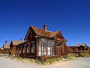
, and Texas. When the resources that had created an employment boom in these towns were consumed, the businesses ceased to exist and the people moved to more productive areas. Sometimes a ghost town consists of many old abandoned buildings (as in Bodie, California
Bodie, California
Bodie is a ghost town in the Bodie Hills east of the Sierra Nevada mountain range in Mono County, California, United States, about 75 miles southeast of Lake Tahoe. It is located east-southeast of Bridgeport, at an elevation of 8379 feet . As Bodie Historic District, the U.S. Department of the...
); elsewhere, there remain only foundations of former buildings (e.g., Graysonia, Arkansas
Graysonia, Arkansas
Graysonia was once a boomtown in Clark County, Arkansas, United States, but has since become a ghost town. It is located on a dirt road in what is now known locally as "the middle of nowhere", halfway between Arkadelphia and Alpine. There are no populated communities in its vicinity and only a few...
). Even some of the earliest settlements in the US are or have been ghost towns, such as Jamestown, Virginia
Jamestown, Virginia
Jamestown was a settlement in the Colony of Virginia. Established by the Virginia Company of London as "James Fort" on May 14, 1607 , it was the first permanent English settlement in what is now the United States, following several earlier failed attempts, including the Lost Colony of Roanoke...
, the Zwaanendael Colony
Zwaanendael Colony
Zwaanendael or Swaanendael was a short lived Dutch colonial settlement in Delaware. It was built in 1631. The name is archaic Dutch spelling for "swan valley" or dale...
in Delaware, and the famous Lost Colony in North Carolina
North Carolina
North Carolina is a state located in the southeastern United States. The state borders South Carolina and Georgia to the south, Tennessee to the west and Virginia to the north. North Carolina contains 100 counties. Its capital is Raleigh, and its largest city is Charlotte...
.
Old mining camps that have lost most of their population at some stage of their history, such as Aspen, Colorado
Aspen, Colorado
The City of Aspen is a Home Rule Municipality that is the county seat and the most populous city of Pitkin County, Colorado, United States. The United States Census Bureau estimates that the city population was 5,804 in 2005...
; Central City, Colorado
Central City, Colorado
Central City is a home rule municipality in Clear Creek and Gilpin counties in the U.S. state of Colorado, and the county seat of Gilpin County. The city population was 515 in the 2000 United States Census...
; Crested Butte, Colorado
Crested Butte, Colorado
Crested Butte is a Home Rule Municipality in Gunnison County, Colorado, United States. A former coal mining town now called "the last great Colorado ski town," Crested Butte is a destination for skiing, mountain biking, and a variety of other outdoor activities...
; Cripple Creek, Colorado
Cripple Creek, Colorado
The City of Cripple Creek is a Statutory City that is the county seat of Teller County, Colorado, United States. Cripple Creek is a former gold mining camp located southwest of Colorado Springs near the base of Pikes Peak. The Cripple Creek Historic District, which received National Historic...
; Deadwood, South Dakota
Deadwood, South Dakota
Deadwood is a city in South Dakota, United States, and the county seat of Lawrence County. It is named for the dead trees found in its gulch. The population was 1,270 according to a 2010 census...
; Marysville, Montana
Marysville, Montana
Marysville is a small unincorporated community in Lewis and Clark County, Montana, United States. In the 1880s and 90's it was a bustling mining town of three thousand residents, and was the center of gold mining in Montana. A few buildings remain, including a baseball field with bleachers...
; Oatman, Arizona
Oatman, Arizona
Oatman is a former mining town in the Black Mountains of Mohave County, Arizona, United States. Located at an elevation of , it began as a tent camp soon after two prospectors struck a $10 million gold find in 1915, though the area had been already settled for a number of years. Oatman's...
; Park City, Utah
Park City, Utah
Park City is a town in Summit and Wasatch counties in the U.S. state of Utah. It is considered to be part of the Wasatch Back. The city is southeast of downtown Salt Lake City and from Salt Lake City's east edge of Sugar House along Interstate 80. The population was 7,558 at the 2010 census...
; St. Elmo, Colorado
St. Elmo, Colorado
St. Elmo is a ghost town in Chaffee County, Colorado, United States. Founded in 1880, St. Elmo lies in the heart of the Sawatch Range, 20 miles southwest of Buena Vista. Nearly 2,000 people settled in this town when mining for gold and silver became evident. The mining industry started to decline...
; Tombstone, Arizona
Tombstone, Arizona
Tombstone is a city in Cochise County, Arizona, United States, founded in 1879 by Ed Schieffelin in what was then Pima County, Arizona Territory. It was one of the last wide-open frontier boomtowns in the American Old West. From about 1877 to 1890, the town's mines produced USD $40 to $85 million...
; and Virginia City, Montana
Virginia City, Montana
Virginia City is a town in and the county seat of Madison County, Montana, United States. In 1961, the town and the surrounding area was designated a National Historic Landmark District, the Virginia City Historic District...
; are sometimes included in the category, although they are active towns and cities today.
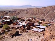
Starting in 2002, an attempt to declare an "Official Ghost Town" in California collapsed when the adherents of the town of Bodie
Bodie, California
Bodie is a ghost town in the Bodie Hills east of the Sierra Nevada mountain range in Mono County, California, United States, about 75 miles southeast of Lake Tahoe. It is located east-southeast of Bridgeport, at an elevation of 8379 feet . As Bodie Historic District, the U.S. Department of the...
, in Northern California
Northern California
Northern California is the northern portion of the U.S. state of California. The San Francisco Bay Area , and Sacramento as well as its metropolitan area are the main population centers...
and those of Calico, in Southern California
Southern California
Southern California is a megaregion, or megapolitan area, in the southern area of the U.S. state of California. Large urban areas include Greater Los Angeles and Greater San Diego. The urban area stretches along the coast from Ventura through the Southland and Inland Empire to San Diego...
could not come to an agreement as to which of their favorites was more deserving.
The ghost town of Medicine Mound
Medicine Mound, Texas
Medicine Mound is a ghost town in southeastern Hardeman County in West Texas. It consists of two buildings, the former Hicks-Cobb general store and the W.W. Cole Building, a combination bank, drugstore, gasoline station , and post office...
in Hardeman County
Hardeman County, Texas
As of the census of 2000, there were 4,724 people, 1,943 households, and 1,319 families residing in the county. The population density was 7 people per square mile . There were 2,358 housing units at an average density of 3 per square mile...
in West Texas
West Texas
West Texas is a vernacular term applied to a region in the southwestern quadrant of the United States that primarily encompasses the arid and semi-arid lands in the western portion of the state of Texas....
is preserved through a museum operated there by Myna Potts
Myna Potts
Myna Gayle Hicks Potts is an historical preservationist from Chillicothe in Hardeman County in West Texas who is the curator of the Medicine Mound Museum in the nearby ghost town of Medicine Mound. Only two buildings remain in the town...
. Medicine Mound consists of two buildings; the museum is in the former Hicks-Cobb General Store
General store
A general store, general merchandise store, or village shop is a rural or small town store that carries a general line of merchandise. It carries a broad selection of merchandise, sometimes in a small space, where people from the town and surrounding rural areas come to purchase all their general...
.
A more recent ghost town is Centralia, Pennsylvania
Centralia, Pennsylvania
Centralia is a borough and ghost town in Columbia County, Pennsylvania, United States. Its population has dwindled from over 1,000 residents in 1981 to 12 in 2005, 9 in 2007, and 10 in 2010, as a result of a mine fire burning beneath the borough since 1962...
, which, at its peak, had over 2,600 residents in either the borough itself or in immediately adjacent areas. It had over 1,000 as recently as 1981 but as of 2010 has seven residents due to an underground mine fire that started in the 1960s when a landfill created from an abandoned strip mine was set on fire. (At the time, it was legal to create a landfill from an abandoned strip mine if it were isolated from any coal seams that could ignite; this loophole has since been closed because of Centralia.) Pennsylvania
Pennsylvania
The Commonwealth of Pennsylvania is a U.S. state that is located in the Northeastern and Mid-Atlantic regions of the United States. The state borders Delaware and Maryland to the south, West Virginia to the southwest, Ohio to the west, New York and Ontario, Canada, to the north, and New Jersey to...
later acquired the borough through eminent domain
Eminent domain
Eminent domain , compulsory purchase , resumption/compulsory acquisition , or expropriation is an action of the state to seize a citizen's private property, expropriate property, or seize a citizen's rights in property with due monetary compensation, but without the owner's consent...
so it could safely move residents to other areas, though a few remain.
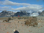
Antarctica
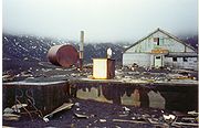
Antarctica also has many more-recently abandoned scientific and military bases, especially in the Antarctic Peninsula
Antarctic Peninsula
The Antarctic Peninsula is the northernmost part of the mainland of Antarctica. It extends from a line between Cape Adams and a point on the mainland south of Eklund Islands....
.
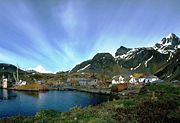
South Georgia and the South Sandwich Islands
The Antarctic island of South GeorgiaSouth Georgia and the South Sandwich Islands
South Georgia and the South Sandwich Islands is a British overseas territory and overseas territory of the European Union in the southern Atlantic Ocean. It is a remote and inhospitable collection of islands, consisting of South Georgia and a chain of smaller islands, known as the South Sandwich...
used to have several thriving whaling settlements during the first half of the 20th century, with a combined population exceeding 2,000 in some years. These included Grytviken
Grytviken
Grytviken is the principal settlement in the British territory of South Georgia in the South Atlantic. It was so named in 1902 by the Swedish surveyor Johan Gunnar Andersson who found old English try pots used to render seal oil at the site. It is the best harbour on the island, consisting of a...
(operating 1904-64), Leith Harbour
Leith Harbour
Leith Harbour , also known as Port Leith, was a whaling station up on the northeast coast of South Georgia, established and operated by Christian Salvesen Ltd, Edinburgh. The station was in operation from 1909 until 1965. It was the largest of seven whaling stations, situated near the mouth of...
(1909–65), Ocean Harbour
Ocean Harbour
Ocean Harbour is a deeply indented bay on the north coast of South Georgia which is entered west-northwest of Tijuca point. It was an active whaling station between 1909–1920...
(1909–20), Husvik
Husvik
Husvik is a former whaling station on the north-central coast of South Georgia Island. It was one of three such stations in Stromness Bay, the other two being Stromness and Leith Harbour. Husvik initially began as a floating, offshore factory site in 1907. In 1910, a land station was constructed...
(1910–60), Stromness
Stromness (South Georgia)
Stromness is a former whaling station on the northern coast of South Georgia Island in the South Atlantic. Its historical significance is that it represents the destination of Ernest Shackleton's epic rescue journey in 1916. See also Stromness Bay...
(1912–61) and Prince Olav Harbour
Prince Olav Harbour
Prince Olav Harbour is small harbour in the south west portion of Cook Bay, entered between Point Abrahamsen and Sheep Point, along the north coast of South Georgia.-Background:...
(1917–34). The abandoned settlements have become increasingly dilapidated, and remain uninhabited nowadays except for the Museum curator's family at Grytviken. The jetty, the church, and dwelling and industrial buildings at Grytviken have recently been renovated by the Government of South Georgia and the South Sandwich Islands
South Georgia and the South Sandwich Islands
South Georgia and the South Sandwich Islands is a British overseas territory and overseas territory of the European Union in the southern Atlantic Ocean. It is a remote and inhospitable collection of islands, consisting of South Georgia and a chain of smaller islands, known as the South Sandwich...
, becoming a popular tourist destination. Some historical buildings in the other settlements are being restored, as well.
Cyprus
The southern part of FamagustaFamagusta
Famagusta is a city on the east coast of Cyprus and is capital of the Famagusta District. It is located east of Nicosia, and possesses the deepest harbour of the island.-Name:...
, also known as Varosha, is fenced off by the Turkish army. Prior to the Turkish Invasion of Cyprus
Turkish invasion of Cyprus
The Turkish invasion of Cyprus, launched on 20 July 1974, was a Turkish military invasion in response to a Greek military junta backed coup in Cyprus...
in 1974, it was the modern tourist area of the city of Famagusta
Famagusta
Famagusta is a city on the east coast of Cyprus and is capital of the Famagusta District. It is located east of Nicosia, and possesses the deepest harbour of the island.-Name:...
. For the last three decades, it has been left as a ghost town.
India
Numerous cities in India have become ghost towns due to various factors. The medieval town of Milakpur Kohi near Sultan GhariSultan Ghari
Sultan Ghari was the first Islamic Mausoleum built in 1231 AD for Prince Nasiru'd-Din Mahmud, eldest son of Iltumish, in the “funerary landscape of Delhi” in the Malakapur village . Iltumish was the first Sultan of the Slave Dynasty who ruled in Delhi from 1210 to 1236 AD...
, Delhi
Delhi
Delhi , officially National Capital Territory of Delhi , is the largest metropolis by area and the second-largest by population in India, next to Mumbai. It is the eighth largest metropolis in the world by population with 16,753,265 inhabitants in the Territory at the 2011 Census...
is one of the oldest ghost towns in northern India. The medieval Mughal Empire
Mughal Empire
The Mughal Empire , or Mogul Empire in traditional English usage, was an imperial power from the Indian Subcontinent. The Mughal emperors were descendants of the Timurids...
towns of Fatehpur Sikri
Fatehpur Sikri
Fatehpur Sikri is a city and a municipal board in Agra district in the state of Uttar Pradesh, India. Built near the much older Sikri, the historical city of Fatehabad, as it was first named, was constructed by Mughal emperor Akbar beginning in 1570...
and Bhangarh
Bhangarh
Bhangarh is a ruined town in the Alwar district of the state of Rajasthan, India, famous for its historical ruins. Bhangarh is at the edge of the Sariska Tiger Reserve.- Description :...
in northern India and the medieval Vijayanagara Empire
Vijayanagara Empire
The Vijayanagara Empire , referred as the Kingdom of Bisnaga by the Portuguese, was an empire based in South Indian in the Deccan Plateau region. It was established in 1336 by Harihara I and his brother Bukka Raya I of the Yadava lineage. The empire rose to prominence as a culmination of attempts...
town of Vijaynagara in southern India are some of the most prominent historical ghost towns in India. One of the most recent ghost towns in India is Dhanushkodi, situated on a low-lying island off the Indian coast. Destroyed by a cyclone in 1964, Dhanushkodi was declared unfit for living after the storm and is a ruin today.
Japan
Hashima IslandHashima Island
For the island in Connecticut, see Thimble Islands., commonly called Gunkanjima or Gunkanshima , is one among 505 uninhabited islands in the Nagasaki Prefecture about 15 kilometers from Nagasaki itself....
was a Japanese mining town from 1887 to 1974. Once known for having the world's highest population density (in 1959 at 83,500 people per square kilometer), the island was abandoned when the coal mines were closed down.
There are plans to abandon various remote depopulated villages and towns due to the falling national population.
Malaysia
Kampung Kepayang in PerakPerak
Perak , one of the 13 states of Malaysia, is the second largest state in the Peninsular Malaysia bordering Kedah and Yala Province of Thailand to the north, Penang to the northwest, Kelantan and Pahang to the east, Selangor the Strait of Malacca to the south and west.Perak means silver in Malay...
state, is almost uninhabited, with only 2 or 3 shophouses being in use. This is a result of the widening of the main road, thus making it difficult to park a vehicle, and result in loss of business of the shops. However, there are still Malay
Malay people
Malays are an ethnic group of Austronesian people predominantly inhabiting the Malay Peninsula, including the southernmost parts of Thailand, the east coast of Sumatra, the coast of Borneo, and the smaller islands which lie between these locations...
s who reside in the village houses behind the shop houses, and the addresses in Simpang Pulai are still written as "Kampung Kepayang."
Oman
Sap Bani Khamis, an abandoned village halfway up a canyon was, is accessible by only a narrow path.Syria
Most of these towns are in ruins and a few serve as tourist attractions. In addition, the Syrian city of QuneitraQuneitra
Quneitra is the largely destroyed and abandoned capital of the Quneitra Governorate in south-western Syria. It is situated in a high valley in the Golan Heights at an elevation of 1,010 metres above sea level...
has become a ghost town after the 1967 Six Day War and subsequent Yom Kippur war
Yom Kippur War
The Yom Kippur War, Ramadan War or October War , also known as the 1973 Arab-Israeli War and the Fourth Arab-Israeli War, was fought from October 6 to 25, 1973, between Israel and a coalition of Arab states led by Egypt and Syria...
in 1973. As of today, the city remains destroyed. Syria has left the ruins in place and built a museum to memorialize the destruction. It maintains billboards at the ruins of many buildings and effectively preserves it in the condition that the Israeli army left it in.
Turkey
KayaköyKayaköy
Kayaköy is a village 8 km south of Fethiye in southwestern Turkey where Anatolian Greek speaking Christians lived until approximately 1923...
in southwestern Turkey was inhabited by Anatolian Greeks until 1923, when a population exchange was agreed by the Turkish and Greek governments. This left the town as a site of empty houses and Greek churches.
Sazak near Karaburun
Karaburun
Karaburun is a district and the center town of the same district in Turkey's İzmir Province. The district area roughly corresponds to the peninsula of the same name which spears north of the tourism resorts of neighboring Çeşme and its dependencies and west of the city of İzmir. In fact, the...
, a district of İzmir Province
Izmir Province
İzmir Province is a province of Turkey in western Anatolia on the Aegean coast, whose capital is the city of İzmir. On the west it is surrounded by the Aegean sea, and it encloses the Gulf of İzmir. Its area is 11,973 km.2, population 3.948.848 . The population was 3,370,866 in 2000...
on the Aegean (western) coast of Turkey, was also inhabited by Greeks, which left the area according to the population exchange treaty. Nowadays Sazak is a total ghost town.
Çökene in Büyükorhan
Büyükorhan
Büyükorhan is a town and district of Bursa Province in the Marmara region of Turkey....
district was a village until 2008. It is a site of empty houses after immigration to big cities due to money shortage and unemployment.
Europe
Sometimes, wars and genocide end a town's life, and it is never resettled. This happened to the Swedish town Sjöstad, Närke
Närke
' is a Swedish traditional province, or landskap, situated in Svealand in south central Sweden. It is bordered by Västmanland to the north, Södermanland to the east, Östergötland to the southeast, Västergötland to the southwest, and Värmland to the northwest...
in 1260, when the town's 700 merchants crossed the ice of Lake Vättern
Vättern
Vättern is the second largest lake in Sweden, after Lake Vänern and the sixth largest lake in Europe. It is a long, finger-shaped body of fresh water in south central Sweden to the southeast of Vänern pointing at the tip of Scandinavia....
and were cut down by the Danes. The Danes then proceeded to the town, ravaging and burning it. The town was never resettled. In a farm town named Skyrstad, ruins and a silver treasure which yielded 4000 coins are all that testify to its existence (see abandoned village
Abandoned village
An abandoned village is a village that has, for some reason, been deserted. In many countries, and throughout history, thousands of villages were deserted for a variety of causes...
). The same happened in the French village Oradour-sur-Glane
Oradour-sur-Glane
Oradour-sur-Glane is a commune in the Haute-Vienne department in the Limousin region in west-central France.The original village was destroyed on 10 June 1944, when 642 of its inhabitants, including women and children, were massacred by a German Waffen-SS company...
in 1944, when occupying German Waffen-SS troops murdered the village's population.
Bulgaria
An increasing number of settlements in Bulgaria are becoming ghost towns as a result of the ongoing demographic decline of the country since the late 20th century. According to the 2001 census, there were 138 uninhabited villages, estimated to have become over 150 by 2006. There are ghost villages in 16 out of the 28 provinces of the country, more numerously in Gabrovo ProvinceGabrovo Province
Gabrovo Province , former name Gabrovo okrug) is a small province lying at the geographical centre of Bulgaria. It is named after its main town - Gabrovo. In 2009 the total population of the area is 130,001.-Municipalities:...
(57 in 2001), Veliko Tarnovo Province
Veliko Tarnovo Province
Veliko Tarnovo is a province in the middle of the northern part of Bulgaria. Its capital city, Veliko Tarnovo, is of historical significance as it is known as the capital of Medieval Bulgaria...
(34), Kardzhali
Kardzhali Province
Kardzhali Province is a province of southern Bulgaria, neighbouring Greece with the Greek prefectures of Xanthi, Rhodope and Evros to the south and east. Kardzhali Province area is 3209.1 km². Its main city is Kardzhali.-History:...
, Blagoevgrad
Blagoevgrad Province
Blagoevgrad Province , also known as Pirin Macedonia , is a province of southwestern Bulgaria. It borders four other Bulgarian provinces to the north and east, Greece to the south, and the Republic of Macedonia to the west. The province has 14 municipalities with 12 towns...
, Burgas
Burgas Province
-Municipalities:The Burgas province contains 13 municipalities . The following table shows the names of each municipality in English and Cyrillic, the main town or village , and the population of each as of 2009.-Demography:The Burgas province had a population of 423,608 -Municipalities:The Burgas...
, and Lovech Province
Lovech Province
Lovech Province is one of the 28 provinces of Bulgaria, lying at the northern centre of the country. It is named after its main city - Lovech. As of December 2009, the population of the area is 151,153.-Municipalities:...
s. Some Bulgarian villages may avoid that fate thanks to immigration of settlers from abroad, mainly from the United Kingdom, but also other EU countries, former Soviet republics, and even Israel and Japan.
Croatia
In Croatia, some SerbianSerbs of Croatia
Višeslav of Serbia, a contemporary of Charlemagne , ruled the Županias of Neretva, Tara, Piva, Lim, his ancestral lands. According to the Royal Frankish Annals , Duke of Pannonia Ljudevit Posavski fled, during the Frankish invasion, from his seat in Sisak to the Serbs in western Bosnia, who...
villages in Lika
Lika
Lika is a mountainous region in central Croatia, roughly bound by the Velebit mountain from the southwest and the Plješevica mountain from the northeast. On the north-west end Lika is bounded by Ogulin-Plaški basin, and on the south-east by the Malovan pass...
and Banovina regions have been depopulated during the war 1991 - 1995. The village of Javornik near Lička Jesenica, being one example, is utterly abandoned. Also, the village of Grablje on the island Hvar
Hvar
- Climate :The climate of Hvar is characterized by mild winters and warm summers. The yearly average air temperature is , 686 mm of precipitation fall on the town of Hvar on average every year and the town has a total of 2800 sunshine hours per year. For comparison Hvar has an average of 7.7...
is abandoned.
Czech Republic
There is a ghost town in MiloviceMilovice
Milovice may refer to several Czech villages:* Milovice * Milovice u Hořic* Milovice * Milovice...
, 30 kilometres (18.6 mi) from the capital, Prague
Prague
Prague is the capital and largest city of the Czech Republic. Situated in the north-west of the country on the Vltava river, the city is home to about 1.3 million people, while its metropolitan area is estimated to have a population of over 2.3 million...
. Milovice consists of four parts, two of which, Milovice-Mladá and Milovice-Boží Dar, were occupied by Soviet soldiers and their families. These two parts were abandoned in 1990-1991 after the Velvet Revolution
Velvet Revolution
The Velvet Revolution or Gentle Revolution was a non-violent revolution in Czechoslovakia that took place from November 17 – December 29, 1989...
. The population was about 20,000. Nowadays, Mladá, the central part of Milovice, is being rebuilt and many young people live there. Boží Dar, as well as the nearby airport, is totally abandoned.
Estonia
Former mining townMining town
A mining community, also known as a mining town or a mining camp, is a community that houses miners. Mining communities are usually created around a mine or a quarry for the extraction or smeltering of ore.-United States:...
s of Viivikonna and Sirgala
Kohtla-Järve
Kohtla-Järve is a city and municipality in north-eastern Estonia, founded in 1924 and incorporated as a town in 1946. The city is highly industrial, and is both a processor of oil shales and is a large producer of various petroleum products. The city is also very diverse ethnically: it contains...
started to lose its population after local oil shale
Oil shale
Oil shale, an organic-rich fine-grained sedimentary rock, contains significant amounts of kerogen from which liquid hydrocarbons called shale oil can be produced...
reserves were being depleted and the industry moved eastwards. In the 21st century both of the towns had only a handful of people left, struggling to find a new place to live in.
Finland
In Finland, which is one of the most sparsely populated countries in the world, most people live in the biggest towns, and some villages near the Russian border and in Lapland are nearly abandoned. . The mining community on JussaröJussarö
Jussarö is an island in Ekenäs , Finland. Jussarö is known by the Jussarö lighthouse. There is also an iron ore mine, but it was closed in 1967. The iron ore occurrence is the biggest undersea level in Finland. In Jussarö some abandoned buildings still remain; which were used by the military until...
island is said to be the only ghost town in Finland.
Germany
Numerous smaller towns and villages in the former eastern territories of Germany were completely destroyed during World War IIWorld War II
World War II, or the Second World War , was a global conflict lasting from 1939 to 1945, involving most of the world's nations—including all of the great powers—eventually forming two opposing military alliances: the Allies and the Axis...
. These territories became part of Poland
Poland
Poland , officially the Republic of Poland , is a country in Central Europe bordered by Germany to the west; the Czech Republic and Slovakia to the south; Ukraine, Belarus and Lithuania to the east; and the Baltic Sea and Kaliningrad Oblast, a Russian exclave, to the north...
and the Soviet Union
Soviet Union
The Soviet Union , officially the Union of Soviet Socialist Republics , was a constitutionally socialist state that existed in Eurasia between 1922 and 1991....
after the war, and many of the smaller settlements were never rebuilt or repopulated.
Greece
The island of SpinalongaSpinalonga
The island of Spinalonga , officially known as Kalydon , is located in the Gulf of Elounda in north-eastern Crete, in Lasithi prefecture, next to the town of Elounda....
is considered by some to be a ghost town. Serving as a leper colony
Leper colony
A leper colony, leprosarium, or lazar house is a place to quarantine leprous people.-History:Leper colonies or houses became widespread in the Middle Ages, particularly in Europe and India, and often run by monastic orders...
for the first half of the 20th century, the island was abandoned when all its inhabitants were cured. By 1962 there were no permanent residents left.
In recent years Spinalonga has become a tourist attraction, with people visiting one of the last leper colonies to be closed down in Europe.
Hungary
Hundreds of villages were abandoned during the OttomanOttoman Empire
The Ottoman EmpireIt was usually referred to as the "Ottoman Empire", the "Turkish Empire", the "Ottoman Caliphate" or more commonly "Turkey" by its contemporaries...
wars in the Kingdom of Hungary
Kingdom of Hungary
The Kingdom of Hungary comprised present-day Hungary, Slovakia and Croatia , Transylvania , Carpatho Ruthenia , Vojvodina , Burgenland , and other smaller territories surrounding present-day Hungary's borders...
in the 16-17th century. Many of them were never repopulated but generally they are not classified as ghost towns because few visible traces remained of them. Real ghost towns are rare in present-day Hungary, except the abandoned villages of Derenk (abandoned in 1943) and Nagygéc (abandoned in 1970). Due to the decrease of rural population beginning in the 1980s, dozens of villages are now threatened with abandonment. The first village officially declared as "dead" was Gyűrűfű in the end of the 1970s, but later it was repopulated as an eco-village. Sometimes depopulated villages were successfully saved as small rural resorts like Kán, Tornakápolna
Tornakápolna
Tornakápolna is a village in Borsod-Abaúj-Zemplén County in northeastern Hungary....
, Szanticska
Szanticska
Szanticska is a former village in Borsod-Abaúj-Zemplén county, Hungary. With a population of 5 people in 2001 Szanticska is famous for being regarded the smallest settlement in Hungary, although officially it is not an independent municipality but part of the village Abaújlak since 1870...
, Gorica, and Révfalu.
Ireland
Several communities became ghost towns in Ireland in the latter half of the nineteenth century, particularly in the west of the country, due to a combination of the Great Famine and economic decline brought on by the famine. These now consist primarily of knee-high ruins of cottages. Notable ghost towns are on Achill IslandAchill Island
Achill Island in County Mayo is the largest island off the coast of Ireland, and is situated off the west coast. It has a population of 2,700. Its area is . Achill is attached to the mainland by Michael Davitt Bridge, between the villages of Gob an Choire and Poll Raithní . A bridge was first...
and in the Burren area of county Clare. Montpelier Hill in the Wicklow Mountains
Wicklow Mountains
The Wicklow Mountains form the largest continuous upland area in Ireland. They occupy the whole centre of County Wicklow and stretch outside its borders into Counties Carlow, Wexford and Dublin. Where the mountains extend into County Dublin, they are known locally as the Dublin Mountains...
was the site of a Hellfire Club
Hellfire Club
The Hellfire Club was a name for several exclusive clubs for high society rakes established in Britain and Ireland in the 18th century, and was more formally or cautiously known as the "Order of the Friars of St. Francis of Wycombe"...
, nearby are the ruins of a castle. A more recent ghost town was created in the 1950s on Great Blasket island, where island life became unfeasible and the island was depopulated.
The village of Killary was created for the film Ryan's Daughter
Ryan's Daughter
Ryan's Daughter is a 1970 film directed by David Lean. The film, set in 1916, tells the story of a married Irish woman who has an affair with a British officer during World War I, despite opposition from her nationalist neighbours...
on the Dingle Peninsula
Dingle Peninsula
The Dingle Peninsula is the northernmost of the major peninsulae in County Kerry. Its ends beyond the town of Dingle at Dunmore Head, the westernmost point of Ireland.-Name:...
. The village in the film was built by the production company from stone so that it could withstand the storms. The empty village remained for some time until the buildings were demolished; only the road that went through the town is still visible.
Italy
In South TyrolSouth Tyrol
South Tyrol , also known by its Italian name Alto Adige, is an autonomous province in northern Italy. It is one of the two autonomous provinces that make up the autonomous region of Trentino-Alto Adige/Südtirol. The province has an area of and a total population of more than 500,000 inhabitants...
, there is a ghost city sunken in the Reschensee (a lake).
Due to urbanization quite a lot of small villages in the Appennini mountains have been abandoned.
In Basilicata
Basilicata
Basilicata , also known as Lucania, is a region in the south of Italy, bordering on Campania to the west, Apulia to the north and east, and Calabria to the south, having one short southwestern coastline on the Tyrrhenian Sea between Campania in the northwest and Calabria in the southwest, and a...
, the ancient site of Craco
Craco
Craco is a commune and medieval village located in the Region of Basilicata and the Province of Matera in Italy. About 25 miles inland from the Gulf of Taranto at the instep of the “boot” of Italy...
(in the province of Matera
Province of Matera
The Province of Matera is a province in the Basilicata region of Italy. Its capital is the city of Matera.It has an area of 3,447 km², and a total population of 203,837 . There are 31 comunes in the province . The main comunes by population are:- External links :* **...
) was depopulated in the middle of the 20th century, due to earthquakes and emigration. The abandonment has made Craco a set of many movies such as The Nativity Story
The Nativity Story
The Nativity Story is a 2006 drama film based on the nativity of Jesus starring Keisha Castle-Hughes and Shohreh Aghdashloo. Filming began on May 1, 2006 in Matera, Italy and in Morocco. New Line Cinema released it on December 1, 2006 in the United States and one week later on December 8 in the...
by Catherine Hardwicke
Catherine Hardwicke
Catherine Hardwicke is an American production designer, film writer and film director. Her works include the independent film Thirteen, which she co-wrote with Nikki Reed, the film's co-star, the Biblically-themed The Nativity Story, the vampire film Twilight, and the werewolf film Red Riding Hood...
, The Passion of the Christ
The Passion of the Christ
The Passion of the Christ is a 2004 American drama film directed by Mel Gibson and starring Jim Caviezel as Jesus. It depicts the Passion of Jesus largely according to the New Testament Gospels of Matthew, Mark, Luke and John...
by Mel Gibson
Mel Gibson
Mel Colm-Cille Gerard Gibson, AO is an American actor, film director, producer and screenwriter. Born in Peekskill, New York, Gibson moved with his parents to Sydney, Australia when he was 12 years old and later studied acting at the Australian National Institute of Dramatic Art.After appearing in...
and Quantum of Solace by Marc Forster
Marc Forster
Marc Forster is a German-Swiss filmmaker and screenwriter. He is best known for directing the films Monster's Ball, Finding Neverland, Stranger than Fiction, The Kite Runner, and Quantum of Solace.- Life and career :...
.
Latvia
Skrunda-1Skrunda-1
Skrunda-1 is a ghost town located 5 km to the north of Skrunda, in Raņķi parish, Latvia. It was the site of two Hen House radar installations constructed in the 1960s...
, site of a former Hen House radar installation in Latvia, is a ghost town that was auctioned off in its entirety in early 2010.
Poland
A Polish ghost towns:-Kłomino (near to Borne Sulinowo
Borne Sulinowo
Borne Sulinowo is a town in Poland's Western Pomeranian Voivodship, in the Powiat of Szczecinek. It is a capital of a separate gmina and home to 4149 inhabitants...
; Russian name - Gródek\Гродек) in the northwest part of the country. It was built for Soviet soldiers and their families. The population was about 5,000. It was completely abandoned in 1992 after the collapse of the USSR. Only a few families live there now, but there are plans to repopulate the city.
-Czerwona Woda (Red water) - in the Klodzko Valley - was built, and left by German villagers before IIWW
many houses are left by people in Klodzko Valley, especially in mountains
Post-Soviet states
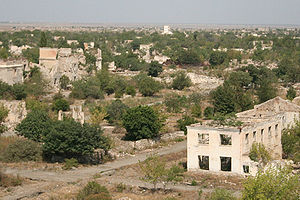
Komi Republic
The Komi Republic is a federal subject of Russia .-Geography:The republic is situated to the west of the Ural mountains, in the north-east of the East European Plain...
, Taymyr
Taymyr Autonomous Okrug
Taymyr Dolgano-Nenets Autonomous Okrug , or Taymyria, was a federal subject of Russia , the northernmost in mainland Russia . It is named after the Taymyr Peninsula...
, Chukotka
Chukotka Autonomous Okrug
Chukotka Autonomous Okrug , or Chukotka , is a federal subject of Russia located in the Russian Far East.Chukotka has a population of 53,824 according to the 2002 Census, and a surface area of . The principal town and the administrative center is Anadyr...
, Iultin
Iultin
Iul'tin is a small airport in Russia located 5 km northeast of Iul'tin. It consists of a small paved airstrip servicing a very remote mining town....
). There are several towns that were established near Soviet concentration camps to supply necessary services. Since most of the Gulag
Gulag
The Gulag was the government agency that administered the main Soviet forced labor camp systems. While the camps housed a wide range of convicts, from petty criminals to political prisoners, large numbers were convicted by simplified procedures, such as NKVD troikas and other instruments of...
installations were abandoned in the 1950s, the towns were abandoned, as well. One such town is located near the former Gulag camp called Butugychag (also called Lower Butugychag). There are several Soviet settlements that were abandoned on the Norwegian island of Svalbard
Svalbard
Svalbard is an archipelago in the Arctic, constituting the northernmost part of Norway. It is located north of mainland Europe, midway between mainland Norway and the North Pole. The group of islands range from 74° to 81° north latitude , and from 10° to 35° east longitude. Spitsbergen is the...
in the town of Grumant
Grumant
Grumant was a Soviet Russian settlement in Svalbard, Norway, established in 1912 and abandoned in 1965. The population peaked at 1106 in 1951/52 . The name ‘Grumant’ is Pomor in origin, and is also use to refer to the whole of the Svalbard archipelago...
. Other towns were deserted due to deindustrialisation and the economic crises of the early 1990 attributed to post-Soviet conflicts
Post-Soviet conflicts
Post-Soviet conflicts are a number of conflicts which engulfed the countries of the former Soviet Union in the years after its breakup. Some of these conflict ended in a stalemate or without a peace treaty, and are referred to as frozen conflicts....
. Agdam
Agdam
Agdam or Ağdam or Aghdam may refer to:*Agdam city, Azerbaijan*Agdam Rayon, Azerbaijan*Ağdam, Khojavend, Azerbaijan*Ağdam, Tovuz, Azerbaijan...
, Azerbaijan is an example of this. Even more semi-deserted towns are situated in Georgia
Georgia (country)
Georgia is a sovereign state in the Caucasus region of Eurasia. Located at the crossroads of Western Asia and Eastern Europe, it is bounded to the west by the Black Sea, to the north by Russia, to the southwest by Turkey, to the south by Armenia, and to the southeast by Azerbaijan. The capital of...
's Abkhazia, notably Tkvarcheli
Tkvarcheli
Tkvarcheli is a town in Abkhazia. It is situated on the river Ghalidzga and the railroad connects it with Ochamchira.-History:...
and Ochamchire
Ochamchire
Ochamchira is a seaside city on the Black Sea coast of Abkhazia, Georgia, and a centre of the eponymous district.According to the 1978 population census, Ochamchira had 18,700 residents. After the Georgian-Abkhaz conflict of 1992-93, Ochamchira experienced a significant population decline due to...
.
In European Russia, many villages have been depopulated since the 1940s.
Scandinavia
PyramidenPyramiden
Pyramiden is an abandoned Russian settlement and coal mining community on the archipelago of Svalbard, Norway. It was founded by Sweden in 1910 and sold to the Soviet Union in 1927...
(Danish, Swedish and Norwegian, meaning "the pyramid", Russian: Пирамида) was a Russian settlement and coal mining community on the archipelago of Svalbard
Svalbard
Svalbard is an archipelago in the Arctic, constituting the northernmost part of Norway. It is located north of mainland Europe, midway between mainland Norway and the North Pole. The group of islands range from 74° to 81° north latitude , and from 10° to 35° east longitude. Spitsbergen is the...
, Norway. It was founded by Sweden in 1910, and sold to the Soviet Union
Soviet Union
The Soviet Union , officially the Union of Soviet Socialist Republics , was a constitutionally socialist state that existed in Eurasia between 1922 and 1991....
in 1927. The settlement, with a one time population of 1,000 inhabitants, was abandoned in the late-1990s by its owner, the state-owned Soviet company Trust Artikugol, and is now a ghost town.
Serbia
Many villages in Serbia are now completely abandoned, mostly due to poor living conditions, particularly in eastern and southern parts of the country.Spain
There are many ghost hamlets in central Spain, as most of their former inhabitants moved to urban areas after the 1960s.Belchite
Belchite
Belchite is a village in the province of Zaragoza, Spain, about 40 km southeast of Zaragoza. It is the capital of Campo de Belchite comarca and is located in a plain surrounded by low hills, the highest of which is Lobo...
, in the province of Zaragoza, Aragon
Aragon
Aragon is a modern autonomous community in Spain, coextensive with the medieval Kingdom of Aragon. Located in northeastern Spain, the Aragonese autonomous community comprises three provinces : Huesca, Zaragoza, and Teruel. Its capital is Zaragoza...
, is one of the most well-known ghost towns in Spain. Before the 1930s, Belchite was a growing city, with many services. As a consequence of the Battle of Belchite
Battle of Belchite (1937)
Battle of Belchite was a group of military operations that took place in the Spanish Civil War between 24 August and 7 September 1937 nearby the town of Belchite, in Aragon.-Prelude:...
, during the Spanish Civil War
Spanish Civil War
The Spanish Civil WarAlso known as The Crusade among Nationalists, the Fourth Carlist War among Carlists, and The Rebellion or Uprising among Republicans. was a major conflict fought in Spain from 17 July 1936 to 1 April 1939...
, the city was totally destroyed. Instead of a reconstruction, dictator Franco
Francisco Franco
Francisco Franco y Bahamonde was a Spanish general, dictator and head of state of Spain from October 1936 , and de facto regent of the nominally restored Kingdom of Spain from 1947 until his death in November, 1975...
decided to keep the ruins of the old town of Belchite intact as a memorial of the battle. As of 1964, the town was totally deserted, the inhabitants having been removed to Belchite Nuevo, on the side of the old town. The ruins, which are not accommodated for tourism, are visited by more than 10,000 tourists annually. It is also a well-known meeting point for Francoist nostalgics, especially Falangist
Falange
The Spanish Phalanx of the Assemblies of the National Syndicalist Offensive , known simply as the Falange, is the name assigned to several political movements and parties dating from the 1930s, most particularly the original fascist movement in Spain. The word means phalanx formation in Spanish....
s.
Ukraine
Since the Chernobyl disasterChernobyl disaster
The Chernobyl disaster was a nuclear accident that occurred on 26 April 1986 at the Chernobyl Nuclear Power Plant in Ukraine , which was under the direct jurisdiction of the central authorities in Moscow...
of 1986, the city of Chernobyl, along with several neighboring cities, have been abandoned.
Prypiat is one of the biggest ghost towns. Pripyat was built to be the home for the workers of the Chernobyl Nuclear Power Plant
Chernobyl Nuclear Power Plant
The Chernobyl Nuclear Power Plant or Chornobyl Nuclear Power Plant is a decommissioned nuclear power station near the city of Pripyat, Ukraine, northwest of the city of Chernobyl, from the Ukraine–Belarus border, and about north of Kiev. Reactor 4 was the site of the Chernobyl disaster in...
. At its peak, it had a population of over 50,000 residents; all abandoned the town after the Chernobyl disaster
Chernobyl disaster
The Chernobyl disaster was a nuclear accident that occurred on 26 April 1986 at the Chernobyl Nuclear Power Plant in Ukraine , which was under the direct jurisdiction of the central authorities in Moscow...
. Unlike the neighboring town Chernobyl
Chernobyl
Chernobyl or Chornobyl is an abandoned city in northern Ukraine, in Kiev Oblast, near the border with Belarus. The city had been the administrative centre of the Chernobyl Raion since 1932....
, Pripyat remains a ghost town and is completely empty.
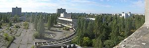
Zone of alienation
The Chernobyl Nuclear Power Plant Zone, which is sometimes referred to as The Chernobyl Zone, The 30 Kilometer Zone, The Zone of Alienation, or simply The Zone The Chernobyl Nuclear Power Plant Zone, which is sometimes referred to as The Chernobyl Zone, The 30 Kilometer Zone, The Zone of...
is full of ghost towns and military installations. After the disaster at Chernobyl NPP, a large area of Ukraine and Belarus was evacuated. This includes quite a few small cities, towns, and villages, as well as a few military installations, such as the Steel Yard
Russian Woodpecker
The Russian Woodpecker was a notorious Soviet signal that could be heard on the shortwave radio bands worldwide between July 1976 and December 1989. It sounded like a sharp, repetitive tapping noise, at 10 Hz, giving rise to the "Woodpecker" name...
Over-the-Horizon radar station. Some of these towns were largely bulldozed and buried due to contamination, but most still have a few remnants, and a few are entirely intact. This area is closed to people, though with the right papers and a guide a person can tour most of this area.
United Kingdom
In the United Kingdom, the once thriving farming village of KnaptoftKnaptoft
Knaptoft is a civil parish in the Harborough district of Leicestershire, England, with a population of around 50. It is also a deserted village in this parish. Knaptoft just off the A5199 near Husbands Bosworth. Knaptoft House Farm nearby is bed and breakfast accommodation and a stud farm...
in Leicestershire
Leicestershire
Leicestershire is a landlocked county in the English Midlands. It takes its name from the heavily populated City of Leicester, traditionally its administrative centre, although the City of Leicester unitary authority is today administered separately from the rest of Leicestershire...
was depopulated due to the enclosure of the surrounding land for sheep pasture. The ruins of the former church still exist, as does a graveyard, with graves even occupying ground inside the ruins of the church. The villages of Imber
Imber
Imber is an uninhabited village in part of the British Army's training grounds on the Salisbury Plain, Wiltshire, England. It is situated in an isolated area of the Plain, about west of the A360 road between Tilshead and West Lavington, accessible only by military tracks...
on Salisbury Plain
Salisbury Plain
Salisbury Plain is a chalk plateau in central southern England covering . It is part of the Southern England Chalk Formation and largely lies within the county of Wiltshire, with a little in Hampshire. The plain is famous for its rich archaeology, including Stonehenge, one of England's best known...
, Wiltshire
Wiltshire
Wiltshire is a ceremonial county in South West England. It is landlocked and borders the counties of Dorset, Somerset, Hampshire, Gloucestershire, Oxfordshire and Berkshire. It contains the unitary authority of Swindon and covers...
and Tyneham
Tyneham
Tyneham is a ghost village in south Dorset, England, near Lulworth on the Isle of Purbeck. It remains a civil parish.-Location:The village is situated northeast of Worbarrow Bay on the Jurassic Coast, about south of Wareham and about west of Swanage. It is part of the Lulworth Estate. Tyneham is...
near Dorset
Dorset
Dorset , is a county in South West England on the English Channel coast. The county town is Dorchester which is situated in the south. The Hampshire towns of Bournemouth and Christchurch joined the county with the reorganisation of local government in 1974...
's historic Jurassic Coast
Jurassic Coast
The Jurassic Coast is a World Heritage Site on the English Channel coast of southern England. The site stretches from Orcombe Point near Exmouth in East Devon to Old Harry Rocks near Swanage in East Dorset, a distance of ....
, as well as several villages within the Stanford Battle Area
Stanford Battle Area
Stanford Battle Area, better known as the Stanford Training Area , is a British Army training area situated in the English county of Norfolk. The area is approximately in size; it is some north of the town of Thetford and south-west of the city of Norwich...
in Norfolk
Norfolk
Norfolk is a low-lying county in the East of England. It has borders with Lincolnshire to the west, Cambridgeshire to the west and southwest and Suffolk to the south. Its northern and eastern boundaries are the North Sea coast and to the north-west the county is bordered by The Wash. The county...
, were forcibly abandoned at the injunction of the British Army
British Army
The British Army is the land warfare branch of Her Majesty's Armed Forces in the United Kingdom. It came into being with the unification of the Kingdom of England and Scotland into the Kingdom of Great Britain in 1707. The new British Army incorporated Regiments that had already existed in England...
, and the abandoned buildings are now used for training exercises. The creation of reservoirs has led to the drowning of villages. These include Mardale Green
Mardale
Mardale is a glacial valley in the Lake District, in northern England. The valley used to have a hamlet at its head, called Mardale Green, but this village was submerged in 1935 when the water level of the valley's lake, Haweswater, was raised to form Haweswater Reservoir by the Manchester...
in the English Lake District
Lake District
The Lake District, also commonly known as The Lakes or Lakeland, is a mountainous region in North West England. A popular holiday destination, it is famous not only for its lakes and its mountains but also for its associations with the early 19th century poetry and writings of William Wordsworth...
and two villages - Ashopton
Ashopton
Ashopton was a village in Derbyshire, England, that was lost along with neighbouring Derwent when the Ladybower Reservoir was constructed in the late 1930s and early 1940s....
and Derwent - drowned by the Ladybower Reservoir
Ladybower Reservoir
Ladybower Reservoir is a large Y-shaped reservoir, the lowest of three in the Upper Derwent Valley in Derbyshire, England. The River Ashop flows into the reservoir from the west; the River Derwent flows south, initially through Howden Reservoir, then Derwent Reservoir, and finally through Ladybower...
in Derbyshire
Derbyshire
Derbyshire is a county in the East Midlands of England. A substantial portion of the Peak District National Park lies within Derbyshire. The northern part of Derbyshire overlaps with the Pennines, a famous chain of hills and mountains. The county contains within its boundary of approx...
. In Wales, the village of Capel Celyn
Capel Celyn
Capel Celyn was a rural community to the north west of Bala in Gwynedd, north Wales, in the Afon Tryweryn valley. The village and other parts of the valley were flooded to create a reservoir, Llyn Celyn, in order to supply Liverpool and The Wirral with water for industry...
was drowned to form Llyn Celyn
Llyn Celyn
Llyn Celyn is a large reservoir constructed between 1960 and 1965 in the valley of the River Tryweryn in Gwynedd, North Wales. It measures roughly 2½ miles long by a mile wide, and has a maximum depth of...
, to provide water for Liverpool, and Llyn Clywedog drowned farmsteads and agricultural land to reduce flooding of the River Severn
River Severn
The River Severn is the longest river in Great Britain, at about , but the second longest on the British Isles, behind the River Shannon. It rises at an altitude of on Plynlimon, Ceredigion near Llanidloes, Powys, in the Cambrian Mountains of mid Wales...
. The village of Nant Gwrtheyrn
Nant Gwrtheyrn
Nant Gwrtheyrn is a Welsh Language and Heritage Centre, located near near the village of Llithfaen on the northern coast of the Llŷn Peninsula, Gwynedd, in northwest Wales....
on the Llŷn peninsula
Llyn Peninsula
The Llŷn Peninsula extends into the Irish Sea from north west Wales, south west of the Isle of Anglesey. It is part of the modern county and historic region of Gwynedd. The name is thought to be of Irish origin, and to have the same root Laigin in Irish as the word Leinster...
, North Wales was an old quarry village which was abandoned in the 1950s after the quarry closed because there was no road leading to the village. It has since been restored as a Welsh-language learning centre.
Across the Highlands of Scotland there are several cleared villages from the Highland Clearances
Highland Clearances
The Highland Clearances were forced displacements of the population of the Scottish Highlands during the 18th and 19th centuries. They led to mass emigration to the sea coast, the Scottish Lowlands, and the North American colonies...
of the 19th century, Suisnish and Boreraig
Boreraig
Boreraig is a deserted township in Strath Swordale on the north shore of Loch Eishort in the parish of Strath, Isle of Skye, Scotland.-History:...
on the Isle of Skye being prime examples.
The phrase "D-village" was used to describe mining villages whose population had been re-located when the colliery closed. This name originates from the classification of pit villages as A, B, C or D with D indicating a village to be depopulated and demolished.
Oceania
Australia
Similar to the United States, Canada and other former frontier countries, most ghost towns in Australia were usually formed after the end of mining operations or the removal of railway services. They are spread throughout the country and are located in every state and territory. Some ghost towns in Australia include CassilisCassilis, Victoria
Cassilis is a ghost town in Gippsland, Victoria, Australia. It was named after a district and castle in Ayrshire, Scotland. In the late 19th century, at the peak of the gold boom, it was a thriving mining centre and home to more than 500 people.-History:...
in Victoria
Victoria (Australia)
Victoria is the second most populous state in Australia. Geographically the smallest mainland state, Victoria is bordered by New South Wales, South Australia, and Tasmania on Boundary Islet to the north, west and south respectively....
, Farina
Farina, South Australia
Farina is a town in the far north of South Australia. The mean annual rainfall is 163.6 mm, although it is highly variable. At the 2006 census, Farina had a population of 55....
in the far north of South Australia, Newnes
Newnes, New South Wales
Newnes located in the Wolgan Valley, New South Wales, Australia, and partly surrounded by the Wollemi National Park, is an abandoned oil shale mining site that was operational in the early 20th centuries...
and Joadja
Joadja, New South Wales
Joadja is a ghost town in the Southern Highlands of New South Wales, Australia, in Wingecarribee Shire.It was a thriving mining town between 1870–1911. It was home for approximately 1100 people, many of Scots ancestry, and was connected to the nearby town of Mittagong by a narrow gauge railway that...
in New South Wales, Gwalia, Goldsworthy
Goldsworthy, Western Australia
Goldsworthy is a former mining town in Western Australia east of Port Hedland and located in the Shire of East Pilbara...
, Cossack
Cossack, Western Australia
Cossack is an historic ghost town located 1,480 km north of Perth and 15 km from Roebourne in the Pilbara region of Western Australia. The nearest town to Cossack is Wickham. At the 2006 census, Cossack had a population of 236....
, and Wittenoom
Wittenoom, Western Australia
Wittenoom is a ghost town located 1,106 kilometres north-northeast of Perth in the Hamersley Range in the Pilbara region of Western Australia. It is the site of Australia's greatest industrial disaster....
in Western Australia. Ravenswood
Ravenswood, Queensland
Ravenswood is a small mining town in Queensland, Australia. The town is located approximately south of Mingela, and about from Charters Towers. At the 2006 census, Ravenswood had a population of 191....
in north-eastern Queensland was a ghost town for many years, due to the declining gold rushes, but new gold discoveries in the area and improved mineral processing technologies have boosted the economy of the area and revived the town.
Old Adaminaby in New South Wales is an example of one of the drowned towns which has been subsequently revealed through drought in recent decades.
New Zealand
Most ghost towns in New Zealand are abandoned gold mining townships. Among the more noteworthy is MacetownMacetown
Macetown is an historic gold mining settlement in the Otago region of the South Island of New Zealand.In 1862 the sailor, William Fox discovered gold in the Arrow River. By the end of that year over 1,500 miners were camped along the river and a small canvas town had grown up at the junction of 12...
in Central Otago
Central Otago
Central Otago is the inland part of the New Zealand region of Otago in the South Island. The area commonly known as Central Otago includes both the Central Otago District and the Queenstown-Lakes District to the west....
Kelso
Kelso, New Zealand
Kelso was a small settlement in Otago, New Zealand, located ten kilometres north of Tapanui on the Kelso River, close to its junction with the larger Pomahaka River...
was abandoned after severe and repeated flooding in the late 1970s and early 1980s.
See also
- Abandoned mine
- Abandoned villageAbandoned villageAn abandoned village is a village that has, for some reason, been deserted. In many countries, and throughout history, thousands of villages were deserted for a variety of causes...
- Deserted medieval villageDeserted medieval villageIn the United Kingdom, a deserted medieval village is a former settlement which was abandoned during the Middle Ages, typically leaving no trace apart from earthworks or cropmarks. If there are fewer than three inhabited houses the convention is to regard the site as deserted; if there are more...
- List of ghost towns
- Old field (ecology)Old field (ecology)Old field is a term used in ecology to describe lands formerly cultivated or grazed but later abandoned. The dominant flora include grasses, heaths and herbaceous plants, with encroaching woody vegetation. It represents an intermediate stage found in ecological succession in an ecosystem advancing...
- Rotten boroughRotten boroughA "rotten", "decayed" or pocket borough was a parliamentary borough or constituency in the United Kingdom that had a very small electorate and could be used by a patron to gain undue and unrepresentative influence within Parliament....
- Unused highwayUnused highwayAn unused highway is a highway or highway ramp that was partially or fully constructed, but was unused or later closed. An unused ramp can be referred to as a stub ramp, stub street, stub-out, or simply stub.-Examples:...
- Urban decayUrban decayUrban decay is the process whereby a previously functioning city, or part of a city, falls into disrepair and decrepitude...
- Urban ExplorationUrban explorationUrban exploration is the examination of the normally unseen or off-limits parts of urban areas or industrial facilities. Urban exploration is also commonly referred to as infiltration, although some people consider infiltration to be more closely associated with the exploration of active or...
External links
- Ghost Town Gallery (With about 200 Ghost Towns throughout the American west)
- Ontario Abandoned Places (Ghost Towns in Canada)
- Ten classic ghost towns worldwide
- GhostTowner.com - The How-To for visiting Ghost Towns
- Coloradopast.com - Ghost Towns and Historic locations in Colorado
- Ghost Town Italy (Italian Language)
- Ghost Towns of Arizona and Surrounding States
Individual places
- Ötzenrath, Germany
- Abandoned towns, villages and other communities in Great Britain
- Map showing the towns buried under Quabbin as they looked in 1912 with original house locations and current reservoir water level
- Dead Lonesome, Part 1 of 2 (Youtube video)
- Dead Lonesome, Part 2 of 2 (Youtube video)
- Are we building Ghost Towns?, Indian Real Estate for Dummies
Chernobyl disaster-related
- Photographic Journey (Note: some statements described as fact on this site are disputed)