Oatman, Arizona
Encyclopedia
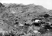
Oatman is a former mining town in the Black Mountains of Mohave County
, Arizona
, United States
. Located at an elevation of 2710 feet (826 m), it began as a tent camp soon after two prospectors struck a $10 million gold find in 1915, though the area had been already settled for a number of years. Oatman's population grew to more than 3,500 in the course of a year.
Oatman has the ZIP code
of 86433. The 86433 ZIP Code Tabulation Area
had a population of 128 at the 2000 census.
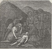
 After a few other names, Oatman was named in the posthumous honor of Olive Oatman
, a young Illinois girl who was kidnapped by (presumably) Yavapai
Indians and forced to work as a slave. She was later traded to Mohave Indians who adopted her as a daughter and had her face tattooed in the custom of the tribe. She was released in 1855 near the current site of the town.
 In 1921, a fire burned down many of Oatman's smaller buildings, but spared the Oatman Hotel. Built in 1902, the now-Oatman Hotel is the oldest two-story adobe structure in Mohave County, a Mohave County historical landmark and is especially famous as the honeymoon stop of Clark Gable
and Carole Lombard
after their wedding in Kingman
on March 18, 1939. Gable fell in love with the area and returned often to play poker with the miners. The Gable/Lombard honeymoon suite is one of the hotel's major attractions. The other is "Oatie the Ghost." "Oatie," actively promoted by the hotel's current owners, is a friendly poltergeist
whose identity is believed to be that of William Ray Flour, an Irish miner who died behind the hotel, presumably from excessive alcohol
consumption. Flour's body wasn't discovered until two days after his death and it was hastily buried in a shallow grave near where he was found.
. Even that advantage was short-lived as the town was completely bypassed in 1953 when a new route between Kingman and Needles was built. By the 1960s
, Oatman was all but abandoned.
 Oatman has undergone a renaissance of sorts in recent years thanks to burgeoning worldwide interest in Route 66 and the explosive growth of the nearby gaming town of Laughlin, Nevada
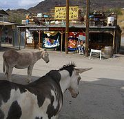
, which promotes visits to the town. Wild burro
s freely roam the town and can be hand-fed carrots and "burro chow," both readily available in practically every store in town. Though normally gentle, the burros are in fact wild and signs posted throughout Oatman advise visitors to exercise caution. The burros are descended from pack animals turned loose by early prospectors, and are protected by the US Department of the Interior. Weekends in Oatman can see anything from classic car rallies to mock "Wild West" shootouts right down the middle of old 66. Independence Day
celebrations include a contest where participants attempt to cook an egg on the sidewalk with the aid of solar devices. Along with the rest of Arizona's US 66 towns, Oatman is fiercely proud of its Route 66 heritage and replicas of 66's black-on-white US highway shield are posted all over the town. Route 66 souvenirs abound and many tourists have pasted autographed one-dollar bills on the walls and ceiling of the Oatman Hotel's bar and restaurant. Estimates of the number of bills run into the thousands.
From Laughlin, Needles or Bullhead City, Arizona
, Oatman is a short drive on State Route 95 to its intersection with Boundary Cone Road in Fort Mohave
. About 10 miles (16 km) east of SR 95, Boundary Cone Road meets with old 66, now named the "Oatman Highway." Oatman is only about four miles (6.5 km) from there.
Mohave County, Arizona
Mohave County is located in the northwestern corner of the U.S. state of Arizona. As of the 2010 census, its population was 200,186, an increase of 45,154 people since the 2000 census count of 155,032. The county seat is Kingman...
, Arizona
Arizona
Arizona ; is a state located in the southwestern region of the United States. It is also part of the western United States and the mountain west. The capital and largest city is Phoenix...
, United States
United States
The United States of America is a federal constitutional republic comprising fifty states and a federal district...
. Located at an elevation of 2710 feet (826 m), it began as a tent camp soon after two prospectors struck a $10 million gold find in 1915, though the area had been already settled for a number of years. Oatman's population grew to more than 3,500 in the course of a year.
Oatman has the ZIP code
ZIP Code
ZIP codes are a system of postal codes used by the United States Postal Service since 1963. The term ZIP, an acronym for Zone Improvement Plan, is properly written in capital letters and was chosen to suggest that the mail travels more efficiently, and therefore more quickly, when senders use the...
of 86433. The 86433 ZIP Code Tabulation Area
ZIP Code Tabulation Area
ZIP Code Tabulation Areas are statistical entities developed by the United States Census Bureau for tabulating summary statistics from Census 2000. This new entity was developed to overcome the difficulties in precisely defining the land area covered by each ZIP code...
had a population of 128 at the 2000 census.
Name

Olive Oatman
Olive Oatman was a woman from Illinois who was famously abducted by a Native American tribe , then sold to another . She ultimately regained her freedom five years later. The story resonated in the media, partly owing to the prominent blue tattooing of Oatman's face by her captors...
, a young Illinois girl who was kidnapped by (presumably) Yavapai
Yavapai people
Yavapai are an indigenous people in Arizona. Historically, the Yavapai were divided into four geographical bands that considered themselves separate peoples: the Tolkapaya, or Western Yavapai, the Yavapé, or Northwestern Yavapai, the Kwevkapaya, or Southeastern Yavapai, and Wipukpa, or Northeastern...
Indians and forced to work as a slave. She was later traded to Mohave Indians who adopted her as a daughter and had her face tattooed in the custom of the tribe. She was released in 1855 near the current site of the town.
Early history

Clark Gable
William Clark Gable , known as Clark Gable, was an American film actor most famous for his role as Rhett Butler in the 1939 Civil War epic film Gone with the Wind, in which he starred with Vivien Leigh...
and Carole Lombard
Carole Lombard
Carole Lombard was an American actress. She was particularly noted for her comedic roles in the screwball comedies of the 1930s...
after their wedding in Kingman
Kingman, Arizona
Kingman is located in a desert climate on the edge of the Mojave Desert, but its higher elevation and location between the Colorado Plateau and the Lower Colorado River Valley tempers summer high temperatures and contributes to winter cold and rare snowfall. Summer daytime highs reach above 90 °F ...
on March 18, 1939. Gable fell in love with the area and returned often to play poker with the miners. The Gable/Lombard honeymoon suite is one of the hotel's major attractions. The other is "Oatie the Ghost." "Oatie," actively promoted by the hotel's current owners, is a friendly poltergeist
Poltergeist
A poltergeist is a paranormal phenomenon which consists of events alluding to the manifestation of an imperceptible entity. Such manifestation typically includes inanimate objects moving or being thrown about, sentient noises and, on some occasions, physical attacks on those witnessing the...
whose identity is believed to be that of William Ray Flour, an Irish miner who died behind the hotel, presumably from excessive alcohol
Alcoholic beverage
An alcoholic beverage is a drink containing ethanol, commonly known as alcohol. Alcoholic beverages are divided into three general classes: beers, wines, and spirits. They are legally consumed in most countries, and over 100 countries have laws regulating their production, sale, and consumption...
consumption. Flour's body wasn't discovered until two days after his death and it was hastily buried in a shallow grave near where he was found.
From gold mining to tourism
1924 would see United Eastern Mines, the town's main employer permanently shut down operations. By 1941, the remainder of the town's gold mining operations were ordered shut down by the US Government as part of the country's war effort since metals other than gold were needed. Oatman was fortunate insofar as it was located on busy U.S. Route 66 and was able to cater to travelers driving between Kingman and Needles, CaliforniaNeedles, California
Needles is a city located in the Mojave Desert on the western banks of the Colorado River in San Bernardino County, California. It is located in the Mohave Valley, which straddles the California–Arizona border. The city is accessible via Interstate 40 and U.S. Route 95...
. Even that advantage was short-lived as the town was completely bypassed in 1953 when a new route between Kingman and Needles was built. By the 1960s
1960s
The 1960s was the decade that started on January 1, 1960, and ended on December 31, 1969. It was the seventh decade of the 20th century.The 1960s term also refers to an era more often called The Sixties, denoting the complex of inter-related cultural and political trends across the globe...
, Oatman was all but abandoned.
Oatman today

Laughlin, Nevada
Laughlin is a census-designated place in Clark County, Nevada, United States, and a port located on the Colorado River. Laughlin is south of Las Vegas, located in the far southern tip of Nevada. It is best known for its gaming, entertainment, and water recreation. As of the 2010 census, the...
, which promotes visits to the town. Wild burro
Burro
The burro is a small donkey used primarily as a pack animal. In addition, significant numbers of feral burros live in the Southwestern United States, where they are protected by law, and in Mexico...
s freely roam the town and can be hand-fed carrots and "burro chow," both readily available in practically every store in town. Though normally gentle, the burros are in fact wild and signs posted throughout Oatman advise visitors to exercise caution. The burros are descended from pack animals turned loose by early prospectors, and are protected by the US Department of the Interior. Weekends in Oatman can see anything from classic car rallies to mock "Wild West" shootouts right down the middle of old 66. Independence Day
Independence Day (United States)
Independence Day, commonly known as the Fourth of July, is a federal holiday in the United States commemorating the adoption of the Declaration of Independence on July 4, 1776, declaring independence from the Kingdom of Great Britain...
celebrations include a contest where participants attempt to cook an egg on the sidewalk with the aid of solar devices. Along with the rest of Arizona's US 66 towns, Oatman is fiercely proud of its Route 66 heritage and replicas of 66's black-on-white US highway shield are posted all over the town. Route 66 souvenirs abound and many tourists have pasted autographed one-dollar bills on the walls and ceiling of the Oatman Hotel's bar and restaurant. Estimates of the number of bills run into the thousands.
From Laughlin, Needles or Bullhead City, Arizona
Bullhead City, Arizona
Bullhead City is a city located on the Colorado River in Mohave County, Arizona, USA, roughly south of Las Vegas, Nevada, and directly across the Colorado River from Laughlin, Nevada, whose casinos and ancillary services supply much of the employment for Bullhead City...
, Oatman is a short drive on State Route 95 to its intersection with Boundary Cone Road in Fort Mohave
Fort Mohave, Arizona
Fort Mohave is a CDP in Mohave County, Arizona. It is named for a nearby fort that was used during the Mohave War. As of the census of 2010, the population of Fort Mohave was 14,364. This was up from 8,919 in 2000. It is a micro-suburb of Bullhead City...
. About 10 miles (16 km) east of SR 95, Boundary Cone Road meets with old 66, now named the "Oatman Highway." Oatman is only about four miles (6.5 km) from there.
See also
- Bullhead City, ArizonaBullhead City, ArizonaBullhead City is a city located on the Colorado River in Mohave County, Arizona, USA, roughly south of Las Vegas, Nevada, and directly across the Colorado River from Laughlin, Nevada, whose casinos and ancillary services supply much of the employment for Bullhead City...
- Fort Mohave, ArizonaFort Mohave, ArizonaFort Mohave is a CDP in Mohave County, Arizona. It is named for a nearby fort that was used during the Mohave War. As of the census of 2010, the population of Fort Mohave was 14,364. This was up from 8,919 in 2000. It is a micro-suburb of Bullhead City...
- Mohave Valley, ArizonaMohave Valley, ArizonaMohave Valley is a census-designated place in Mohave County, Arizona, United States. The population was 13,694 at the 2000 census. It is geographically connected to Needles, California and Bullhead City, Arizona....
External links
- Oatman and Gold Road Chamber of Commerce - Information and events
- Oatman at Western Mining History

