
Chilean Coast Range
Encyclopedia
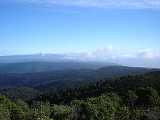
The Chilean Coastal Range is a mountain range that runs from north to south along the Pacific coast of South America
parallel to the Andean Mountains
, extending from Morro de Arica
in the north to Taitao Peninsula
, where it ends at the Chile Triple Junction
, in the south. The range has a strong influence on the climate of Chile
since it produces a rain shadow
to the east. Because of this the vegetation growing on the seaward slopes is much more exuberant than in the interior. Compared to the coastal lowlands and the Intermediate Depression it is sparsely populated with land use varying from protected areas
to grazing and silviculture. The range is present in all Chilean regions except for Coquimbo Region
and Magallanes Region.
in the north and reaches its highest point, of 3114 m, in Sierra Vicuña Mackenna in the Antofagasta Region. Between Copiapó
and Aconcagua
rivers, in the so called Norte Chico
region, the range fuses with the Andes. Just north of Santiago the range separates from the Andes but comes close to it again near Paine
, a southern suburb of Santiago, and San Fernando
. From Santiago south the range loses height until reaching the Bío-Bío River
, beyond which the Nahuelbuta range emerges which reaches about 1500 m in its central parts. South of Nahuelbuta Range, in the Araucanía Region
, the coastal range is replaced by a flatland area. South of Toltén River
the range rises again as the Cordillera de Mahuidanchi. Beyond the heights of Corral this range changes into Cordillera Pelada. From Chacao Channel
south the range is penetrated by the sea creating islands and peninsulas. Chiloé Island
, the largest of these, has two ranges: Piuchén Range
from Chacao Channel to Cucao Lake and Pirulil Range
in the southern half. South of Chiloé the portions of the range above sea level form the Guaitecas
and the Chonos Archipelago
s. The southern extreme of the range forms the Taitao Peninsula
and its sub-peninsula Tres Montes
.
The range can be divided in several minor ranges. Some of these ranges and their boundaries are:
s and accretionary wedge
s along Chile's coast. The range was separated from the Andes during the Tertiary
rise of the Andes due to the subsidence
of the Intermediate Depression.
The range is made of different lithological
units. From Valparaíso Region
to Lanalhue Fault
the bedrock
is largely made up of Carboniferous
-Permian
granitoid
s. These igneous rocks were once part of a proto-Andean magmatic belt. South of Lanalhue Fault most of the range is an accretionary wedge
formed along the subduction zone at South America
s western margin by at least the Paleozoic
. From Lanalhue to Pirulil Range
the range is dominated by medium grade metamorphic rocks including schist
s. The analogous granites of the northern part of the coast range are placed inside the Andes in this latitudes.
While during the Miocene
regions of the Chilean Coast Range hosted several volcanoes it does not show any sign of volcanic activity at present.
South America
South America is a continent situated in the Western Hemisphere, mostly in the Southern Hemisphere, with a relatively small portion in the Northern Hemisphere. The continent is also considered a subcontinent of the Americas. It is bordered on the west by the Pacific Ocean and on the north and east...
parallel to the Andean Mountains
Andes
The Andes is the world's longest continental mountain range. It is a continual range of highlands along the western coast of South America. This range is about long, about to wide , and of an average height of about .Along its length, the Andes is split into several ranges, which are separated...
, extending from Morro de Arica
Morro de Arica
Morro de Arica is a steep hill located in the Chilean city of Arica. Its height is 139 metres above sea level. It was the last bulwark of defence for the Peruvian troops who garrisoned the city during the War of the Pacific...
in the north to Taitao Peninsula
Taitao Peninsula
The Taitao Peninsula is a westward projection of the mainland of Chile, with which it is connected by the narrow Isthmus of Ofqui, over which the natives and early missionaries were accustomed to carry their boats between the Moraleda Channel and Gulf of Penas...
, where it ends at the Chile Triple Junction
Chile Triple Junction
The Chile Triple Junction is a geologic triple junction located on the seafloor of the Pacific Ocean off Taitao and Tres Montes Peninsula on the southern coast of Chile. Here three tectonic plates meet: the South American Plate, the Nazca Plate, and the Antarctic Plate...
, in the south. The range has a strong influence on the climate of Chile
Climate of Chile
The climate of Chile comprises a wide range of weather conditions across a large geographic scale, extending across 38 degrees in latitude, making generalisations difficult...
since it produces a rain shadow
Rain shadow
A rain shadow is a dry area on the lee side of a mountainous area. The mountains block the passage of rain-producing weather systems, casting a "shadow" of dryness behind them. As shown by the diagram to the right, the warm moist air is "pulled" by the prevailing winds over a mountain...
to the east. Because of this the vegetation growing on the seaward slopes is much more exuberant than in the interior. Compared to the coastal lowlands and the Intermediate Depression it is sparsely populated with land use varying from protected areas
Protected areas of Chile
The protected areas of Chile are areas that have natural beauty or significant historical value protected by the government of Chile. These protected areas cover over , which is 19% of the territory of Chile...
to grazing and silviculture. The range is present in all Chilean regions except for Coquimbo Region
Coquimbo Region
The IV Coquimbo Region is one of Chile's 15 first order administrative divisions. It is some 400 km north of the capital, Santiago.The capital and largest city is La Serena, other important cities include the seaport Coquimbo and the agricultural centre...
and Magallanes Region.
Geography
Like the Andes, the coastal range becomes progressively lower with increasing latitude. The range begins at Morro de AricaMorro de Arica
Morro de Arica is a steep hill located in the Chilean city of Arica. Its height is 139 metres above sea level. It was the last bulwark of defence for the Peruvian troops who garrisoned the city during the War of the Pacific...
in the north and reaches its highest point, of 3114 m, in Sierra Vicuña Mackenna in the Antofagasta Region. Between Copiapó
Copiapó
Copiapó is a city in northern Chile, located about 40 miles east of the coastal town of Caldera. Founded on December 8, 1744, it is the capital of Copiapó Province and Atacama Region....
and Aconcagua
Aconcagua River
For other uses, see Aconcagua .The Aconcagua River is a river in Chile that rises from the joint of two minor tributary rivers at above sea level in the Andes, Juncal river from the east and Blanco river from the south east...
rivers, in the so called Norte Chico
Norte Chico, Chile
The Norte Chico is one of the five natural regions on which CORFO divided continental Chile in 1950. Its northern border is formed by the limit with the Far North, on west lies the Pacific Ocean, by the east the Andes mountains and Argentina, and by the south the Zona Central natural region...
region, the range fuses with the Andes. Just north of Santiago the range separates from the Andes but comes close to it again near Paine
Paine, Chile
Paine is a Chilean city, forming part of Greater Santiago, and a commune in the Maipo Province, Santiago Metropolitan Region.-Demographics:According to the 2002 census of the National Statistics Institute, Paine spans an area of and has 50,028 inhabitants . Of these, 31,622 lived in urban areas...
, a southern suburb of Santiago, and San Fernando
San Fernando, Chile
San Fernando is the capital of the province of Colchagua, in central Chile, and the second most populated urban center of the O'Higgins Region. Located close to the Tinguiririca River in a fertile valley, San Fernando sits 1,112 feet above sea level...
. From Santiago south the range loses height until reaching the Bío-Bío River
Bío-Bío River
The Biobío River is the second largest river in Chile. It originates from Icalma and Galletué lakes in the Andes and flows 380 km to the Gulf of Arauco on the Pacific Ocean....
, beyond which the Nahuelbuta range emerges which reaches about 1500 m in its central parts. South of Nahuelbuta Range, in the Araucanía Region
Araucanía Region
The IX Araucanía Region is one of Chile's 15 first order administrative divisions and comprises two provinces: Malleco in the north and Cautín in the south....
, the coastal range is replaced by a flatland area. South of Toltén River
Toltén River
Toltén River is a river located in the Araucanía Region of Chile. It rises at Villarrica Lake, close to the city of the same name. Its major tributary is Allipén River...
the range rises again as the Cordillera de Mahuidanchi. Beyond the heights of Corral this range changes into Cordillera Pelada. From Chacao Channel
Chacao Channel
The Chacao Channel is located in Los Lagos Region, Chile and separates Chiloé Island from mainland Chile. The channel was created during the Quaternary glaciations by successive glaciers that flowed down fron the Andes to the coast...
south the range is penetrated by the sea creating islands and peninsulas. Chiloé Island
Chiloé Island
Chiloé Island , also known as Greater Island of Chiloé , is the largest island of the Chiloé Archipelago off the coast of Chile, in the Pacific Ocean...
, the largest of these, has two ranges: Piuchén Range
Piuchén Range
Piuchén Range is one of the two mountain range located in Chiloé Island, southern Chile. It is located along the Pacific coast and forms part of the larger Chilean Coast Range. It northern boundary is the Chacao Channel while to the south it is separated from the Pirulil Range by Cucao Lake.-See...
from Chacao Channel to Cucao Lake and Pirulil Range
Pirulil Range
The Pirulil Range is a mountain range located in the southern half of Chiloé Island. It is located along the Pacific coast and forms part of the larger Chilean Coast Range. It northern boundary is the Cucao Lake, beyond of which the Piuchén Range rises. To the south the range ends at Corcovado...
in the southern half. South of Chiloé the portions of the range above sea level form the Guaitecas
Guaitecas Archipelago
Guaitecas Archipelago is an archipelago in the municipality of Guaitecas in the Aisén province. The Ciprés de las Guaitecas tree is named after the archipelago. The only settlement in the archipelago is Melinka....
and the Chonos Archipelago
Chonos Archipelago
Chonos Archipelago is a series of low mountainous elongated islands with deep bays, traces of a submerged Chilean Coast Range. Most of the islands are forested with little or no human settlement...
s. The southern extreme of the range forms the Taitao Peninsula
Taitao Peninsula
The Taitao Peninsula is a westward projection of the mainland of Chile, with which it is connected by the narrow Isthmus of Ofqui, over which the natives and early missionaries were accustomed to carry their boats between the Moraleda Channel and Gulf of Penas...
and its sub-peninsula Tres Montes
Tres Montes Peninsula
The Tres Montes Peninsula is a southwestward projection of Taitao Peninsula which in turn connects to the mainland of Chile by the narrow Isthmus of Ofqui. The peninsula is situated in Aisén Region close to the Chile Triple Junction of the Nazca, Antarctic and South American Plate....
.
The range can be divided in several minor ranges. Some of these ranges and their boundaries are:
- Sierra Vicuña MackennaCordillera Vicuña MackennaThe Cordillera Vicuña Mackenna is the highest section of the Chilean Coast Range located in northern Chile, west of Pampa del Tamarugal. It runs north-south for approximately 170 km parallel to the Andes. The driest parts of Atacama Desert are located east of the range due to the rain shadow...
(24-25° S) - Cordillera de Nahuelbuta (37-38° S)
- ImperialImperial RiverImperial River may refer to one of the following rivers:In South America:*Imperial River In the United States:*Imperial River...
-Toltén RiverToltén RiverToltén River is a river located in the Araucanía Region of Chile. It rises at Villarrica Lake, close to the city of the same name. Its major tributary is Allipén River...
lowland
- Imperial
- Cordillera de QueuleCordillera de QueuleCordillera de Queule is a minor mountain range in the border of Araucanía Region and Los Ríos Region, southern Chile. The forested hills of Cordillera de Queule makes up the northern boundary of Lingue Rivers drainage basin....
(39°) - Cordillera de Mahuidanchi (39° S)
- Cordillera Pelada (40-41° S)
- Piuchén RangePiuchén RangePiuchén Range is one of the two mountain range located in Chiloé Island, southern Chile. It is located along the Pacific coast and forms part of the larger Chilean Coast Range. It northern boundary is the Chacao Channel while to the south it is separated from the Pirulil Range by Cucao Lake.-See...
(42° S)- Cucao and Huillinco LakeCucao and HuillincoCucao and Huillinco are two lakes in central Chiloé Island, Chile, linked by a strait forming one hydrologic lake. The two lakes are orinted in west-east fashion cutting of the Chilean Coast Range in Chiloé Island into two ranges; Piuchén to north and Pirulil to the south...
- Cucao and Huillinco Lake
- Pirulil RangePirulil RangeThe Pirulil Range is a mountain range located in the southern half of Chiloé Island. It is located along the Pacific coast and forms part of the larger Chilean Coast Range. It northern boundary is the Cucao Lake, beyond of which the Piuchén Range rises. To the south the range ends at Corcovado...
(42-43° S)
Geology
The range has no single structural or lithological origin but is the result of the alignment of horst, forearc highForeland basin
A foreland basin is a depression that develops adjacent and parallel to a mountain belt. Foreland basins form because the immense mass created by crustal thickening associated with the evolution of a mountain belt causes the lithosphere to bend, by a process known as lithospheric flexure...
s and accretionary wedge
Accretionary wedge
An accretionary wedge or accretionary prism is formed from sediments that are accreted onto the non-subducting tectonic plate at a convergent plate boundary...
s along Chile's coast. The range was separated from the Andes during the Tertiary
Tertiary
The Tertiary is a deprecated term for a geologic period 65 million to 2.6 million years ago. The Tertiary covered the time span between the superseded Secondary period and the Quaternary...
rise of the Andes due to the subsidence
Subsidence
Subsidence is the motion of a surface as it shifts downward relative to a datum such as sea-level. The opposite of subsidence is uplift, which results in an increase in elevation...
of the Intermediate Depression.
The range is made of different lithological
Lithology
The lithology of a rock unit is a description of its physical characteristics visible at outcrop, in hand or core samples or with low magnification microscopy, such as colour, texture, grain size, or composition. It may be either a detailed description of these characteristics or be a summary of...
units. From Valparaíso Region
Valparaíso Region
The V Valparaíso Region is one of Chile's 15 first order administrative divisions.Valparaíso Region, 2006 With the country's third highest population of 1,539,852 million in 2002 and third smallest area of , the region is Chile's second most densely populated after the Santiago Metropolitan Region...
to Lanalhue Fault
Lanalhue Fault
Lanalhue Fault is a fault once active in the Paleozoic located in south-central Chile that cuts through Cordillera de Nahuelbuta. The fault takes name from Lanalhue Lake which overlies part of fault. The lanalhue fault makes up a major lithological boundary in the Chilean Coast Range to which...
the bedrock
Bedrock
In stratigraphy, bedrock is the native consolidated rock underlying the surface of a terrestrial planet, usually the Earth. Above the bedrock is usually an area of broken and weathered unconsolidated rock in the basal subsoil...
is largely made up of Carboniferous
Carboniferous
The Carboniferous is a geologic period and system that extends from the end of the Devonian Period, about 359.2 ± 2.5 Mya , to the beginning of the Permian Period, about 299.0 ± 0.8 Mya . The name is derived from the Latin word for coal, carbo. Carboniferous means "coal-bearing"...
-Permian
Permian
The PermianThe term "Permian" was introduced into geology in 1841 by Sir Sir R. I. Murchison, president of the Geological Society of London, who identified typical strata in extensive Russian explorations undertaken with Edouard de Verneuil; Murchison asserted in 1841 that he named his "Permian...
granitoid
Granitoid
A granitoid or granitic rock is a variety of coarse grained plutonic rock similar to granite which mineralogically are composed predominately of feldspar and quartz. Examples of granitoid rocks include granite, quartz monzonite, quartz diorite, syenite, granodiorite and trondhjemite. Many are...
s. These igneous rocks were once part of a proto-Andean magmatic belt. South of Lanalhue Fault most of the range is an accretionary wedge
Accretionary wedge
An accretionary wedge or accretionary prism is formed from sediments that are accreted onto the non-subducting tectonic plate at a convergent plate boundary...
formed along the subduction zone at South America
South America
South America is a continent situated in the Western Hemisphere, mostly in the Southern Hemisphere, with a relatively small portion in the Northern Hemisphere. The continent is also considered a subcontinent of the Americas. It is bordered on the west by the Pacific Ocean and on the north and east...
s western margin by at least the Paleozoic
Paleozoic
The Paleozoic era is the earliest of three geologic eras of the Phanerozoic eon, spanning from roughly...
. From Lanalhue to Pirulil Range
Pirulil Range
The Pirulil Range is a mountain range located in the southern half of Chiloé Island. It is located along the Pacific coast and forms part of the larger Chilean Coast Range. It northern boundary is the Cucao Lake, beyond of which the Piuchén Range rises. To the south the range ends at Corcovado...
the range is dominated by medium grade metamorphic rocks including schist
Schist
The schists constitute a group of medium-grade metamorphic rocks, chiefly notable for the preponderance of lamellar minerals such as micas, chlorite, talc, hornblende, graphite, and others. Quartz often occurs in drawn-out grains to such an extent that a particular form called quartz schist is...
s. The analogous granites of the northern part of the coast range are placed inside the Andes in this latitudes.
While during the Miocene
Miocene
The Miocene is a geological epoch of the Neogene Period and extends from about . The Miocene was named by Sir Charles Lyell. Its name comes from the Greek words and and means "less recent" because it has 18% fewer modern sea invertebrates than the Pliocene. The Miocene follows the Oligocene...
regions of the Chilean Coast Range hosted several volcanoes it does not show any sign of volcanic activity at present.
See also
- Climate of ChileClimate of ChileThe climate of Chile comprises a wide range of weather conditions across a large geographic scale, extending across 38 degrees in latitude, making generalisations difficult...
- Geology of ChileGeology of ChileThe Geology of Chile is mainly a product of the Andean and preceding orogenies which are caused by the long-lived convergent boundary at South America's western coast. While in the Paleozoic and Precambrian this boundary was affected by the accretion of terranes and microcontinents it has since...
- Chilean Central ValleyChilean Central ValleyThe Central Valley , Intermediate Depression or Longitudinal Valley is the depression between the Chilean Costal Range and the Andes Mountains. The central valley should not be confused with Central Chile that encompasses part of the valley...
- Atacama DesertAtacama DesertThe Atacama Desert is a plateau in South America, covering a strip of land on the Pacific coast, west of the Andes mountains. It is, according to NASA, National Geographic and many other publications, the driest desert in the world...