
South Georgia and the South Sandwich Islands
Encyclopedia
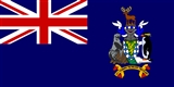
South Georgia and the South Sandwich Islands (SGSSI) is a British overseas territory and overseas territory of the European Union
in the southern Atlantic Ocean. It is a remote and inhospitable collection of islands, consisting of South Georgia and a chain of smaller islands, known as the South Sandwich Islands. South Georgia is 167.4 kilometres (104 mi) long and 1.4 to 37 km (0.869921831309729 to 23 mi) wide and is by far the largest island in the territory. The South Sandwich Islands lie about 520 kilometres (323.1 mi) southeast of South Georgia. The total land area of the territory is 3903 square kilometres (1,507 sq mi).
There is no native population on the islands; the present inhabitants are the British Government Officer, Deputy Postmaster, scientists, and support staff from the British Antarctic Survey
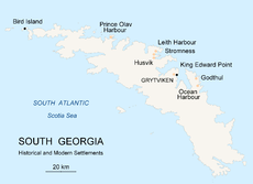
who maintain scientific bases at Bird Island
and at the capital, King Edward Point
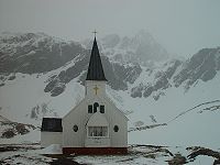
, as well as museum staff at nearby Grytviken
.
The United Kingdom claimed sovereignty
over South Georgia in 1775 and the South Sandwich Islands in 1908. In 1908 the United Kingdom annexed both South Georgia and the South Sandwich Islands. The territory of "South Georgia and the South Sandwich Islands" was formed in 1985; previously it had been governed as part of the Falkland Islands Dependencies
. Argentina
claimed South Georgia in 1927 and claimed the South Sandwich Islands in 1938.
Argentina maintained a naval station, Corbeta Uruguay
on Thule Island
in the South Sandwich Islands, from 1976 until 1982 when it was closed by the Royal Navy
. The Argentine claim over South Georgia contributed to the 1982 Falklands War
, during which Argentine forces briefly occupied the island. Argentina continues to claim sovereignty
over South Georgia and the South Sandwich Islands.
, a London merchant, and was named Roche Island on a number of early maps. It was sighted by a commercial Spanish ship named León operating out of Saint-Malo
on 28 June or 29 June 1756.
Captain James Cook
circumnavigated the island in 1775 and made the first landing. He claimed the territory for the Kingdom of Great Britain
, and named it "the Isle of Georgia" in honour of King George III
. British arrangements for the government of South Georgia were first established under the 1843 British Letters Patent
.
In 1882–1883, a German expedition for the First International Polar Year
was stationed at Royal Bay
on the southeast side of the island. The scientists of this group observed the transit of Venus
and recorded waves produced by the 1883 eruption of Krakatoa
.
Throughout the 19th century, South Georgia was a sealers' base
as well as a whalers'
base beginning in the 20th century, until whaling
ended in the 1960s. A Norwegian, Carl Anton Larsen
, established the first land-based whaling station and first permanent habitation at Grytviken
in 1904. It operated through his Argentine Fishing Company
, which settled in Grytviken. The station remained in operation until 1965.
Whaling stations operated under leases granted by the (British) Governor of the Falkland Islands
. The seven stations, all on the north coast with its sheltered harbours were, starting from the west:
With the end of the whaling industry, the stations were abandoned. Apart from a few preserved buildings such as the museum and church at Grytviken, only their decaying remains survive.
 From 1905, the Argentine Meteorological Office cooperated in maintaining a meteorological observatory at Grytviken under the British lease requirements of the whaling station until these changed in 1949.
In 1908 the United Kingdom issued a further Letters Patent
to establish constitutional arrangements for its possessions in the South Atlantic. The Letters Patent covered South Georgia, the South Orkneys, the South Shetlands, the South Sandwich Islands, and Graham Land
. (The claim was extended in 1917 to include a sector of Antarctica reaching to the South Pole
.)
In 1909 an administrative centre and residence were established at King Edward Point on South Georgia, near the whaling station of Grytviken. A permanent local British administration and resident Magistrate
exercised effective possession, enforcement of British law, and regulation of all economic, scientific and other activities in the territory, which was then governed as the Falkland Islands Dependencies
.
In about 1912, what is according to some accounts the largest whale ever caught, a blue whale
of 33.58 metres (110 ft), was landed at Grytviken.
In April 1916, Ernest Shackleton
's Imperial Trans-Antarctic Expedition
became stranded on Elephant Island, some 800 miles (1,287.5 km) southwest of South Georgia. Shackleton and five companions set out in a small boat to summon help, and on 10 May, after an epic voyage, they landed at King Haakon Bay
on South Georgia's south coast. While three stayed at the coast, Shackleton and the two others( one being Irish man Tom Crean) went on to cover 22 miles (35.4 km) overland to reach help at Stromness whaling station. The remaining 22 members of the expedition, who had stayed on Elephant Island, were subsequently rescued. In January 1922, during a later expedition, Shackleton died on board ship off South Georgia. He is buried at Grytviken.
Argentina claimed South Georgia in 1927.
 During World War II the Royal Navy deployed an armed merchant vessel to patrol South Georgian and Antarctic waters against German
raiders
, along with two four-inch shore guns (still present) protecting Cumberland Bay and Stromness Bay, manned by volunteers from among the Norwegian whalers. The base at King Edward Point was expanded as a research facility in 1949/1950 by the British Antarctic Survey
, which until 1962 was called the Falkland Islands Dependencies Survey.
The Falklands War
was precipitated on 19 March 1982 when a group of Argentinians, posing as scrap metal merchants, occupied the abandoned whaling station at Leith Harbour
on South Georgia. On 3 April the Argentine troops attacked and occupied Grytviken. Among the commanding officers of the Argentine Garrison was Alfredo Astiz
, a Captain in the Argentine Navy
who, years later, was convicted of felonies committed during the Dirty War
in Argentina.
The island was recaptured by British forces on 25 April in Operation Paraquet
. In 1985 South Georgia and the South Sandwich Islands ceased to be administered as a Falkland Islands Dependency and became a separate territory. The King Edward Point
base, which had become a small military garrison after the Falklands war
, returned to civilian use in 2001 and is now operated by the British Antarctic Survey
.
discovered the southern eight islands of the Sandwich Islands Group in 1775, although he lumped the southernmost three together, and their status as separate islands was not established until 1820 by Fabian Gottlieb von Bellingshausen
. The northern three islands were discovered by Bellingshausen in 1819. The islands were tentatively named "Sandwich Land" by Cook, although he also commented that they might be a group of islands rather than a single body of land. The name was chosen in honour of the 4th Earl of Sandwich
, 1st Lord of the Admiralty. The word "South" was later added to distinguish them from the "Sandwich Islands", now known as Hawaii
.
The United Kingdom formally annexed the South Sandwich Islands through the 1908 Letters Patent, grouping them with other British-held territory in Antarctica as the Falkland Islands Dependencies.
Argentina claimed the South Sandwich Islands in 1938, and challenged British sovereignty in the Islands on several occasions. From 25 January 1955, through mid-1956 Argentina maintained the summer station Teniente Esquivel at Ferguson Bay
on the southeastern coast of Thule Island
. Argentina maintained a naval base (Corbeta Uruguay
) from 1976 to 1982, in the lee (southern east coast) of the same island. Although the British discovered the presence of the Argentine base in 1978, protested and tried to resolve the issue by diplomatic means, no effort was made to remove them by force until after the Falklands War
. The base was removed on 20 June 1982.
On 10 February 2008, a 6.5 magnitude earthquake
had its epicentre 205 km (127 mi) SSE of Bristol Island
. On 30 June 2008 at 06:17:53 UTC, a 7.0 magnitude earthquake struck the region. Its epicentre was at 58.160S 21.893W, 283 km (176 mi) ENE (73 degrees) of Bristol Island.
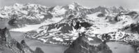
 South Georgia and the South Sandwich Islands are a collection of islands in the South Atlantic Ocean. Most of the islands, rising steeply from the sea, are rugged and mountainous. At higher elevations the islands are permanently covered with ice and snow.
. The highest peak is Mount Paget
in the Allardyce Range
at 2934 metres (9,626 ft).
Geologically, the island consists of gneiss
and argillaceous schist
s, with no trace of fossils, showing that the island is, like the Falkland Islands, a surviving fragment of some greater land-mass now vanished, most probably indicating a former extension of the Andean system.
Smaller islands and islets off the coast of South Georgia Island include:
The following remote rocks are also considered part of the South Georgia Group:
 The South Sandwich Islands (Spanish name: Islas Sandwich del Sur) comprise 11 mostly volcanic
islands (excluding tiny satellite islands and offshore rocks), with some active volcanoes. They form an island arc
running north-south in the region 56°18'–59°27'S, 26°23'–28°08'W, between about 350 miles (563.3 km) and 500 miles (804.7 km) southeast of South Georgia.
The northernmost of the South Sandwich Islands form the Traversay Islands
and Candlemas Islands
groups, while the southernmost make up Southern Thule
. The three largest islands – Saunders
, Montagu
and Bristol
– lie between the two. The Islands' highest point is Mount Belinda (1370 m (4,495 ft)) on Montagu Island.
The South Sandwich Islands are uninhabited, though a permanently manned Argentine research station was located on Thule Island
from 1976 to 1982 (for details, see "History" section above). There are automatic weather stations on Thule (Morrell) Island
and Zavodovski
. To the northwest of Zavodovski Island is the Protector Shoal
, a submarine volcano.
The following table lists the South Sandwich Islands from north to south:
A series of six passages separates each of the islands or island groups in the chain. They are, from north to south: Zavodovski I. — Traverse passage — Visokoi I. — Brown's passage — Candlemas Is. — Shackleton's passage — Saunders I. — Larsen's passage — Montagu I. — Biscoe's passage — Bristol I. — Forster's passage — Southern Thule. Nelson Channel is the passage between Candlemas and Vindication Is.
 The permanently cold sea maintains a cold maritime climate on the islands, and the weather is highly variable and harsh. Typical daily maximum temperatures in South Georgia at sea level are around 0 °C (32 °F) in winter (August) and 8 °C (46.4 °F) in summer (January). Winter minimum temperatures are typically about −5 °C and rarely dip below −10 °C. Annual precipitation in South Georgia is about 1500 mm (59.1 in), much of which falls as sleet or snow, which is possible in any month. Inland, the snow line in summer is at an altitude of about 300 m (984 ft).
Westerly winds blow throughout the year interspersed with periods of calm - Indeed, in 1963, 25% of winds were in the calm category at King Edward point, and the mean wind speed of around 8 knots is around half that of the Falkland Islands. This gives the eastern side of South Georgia (leeward side) a more pleasant climate than the exposed western side. The prevailing weather conditions generally make the islands difficult to approach by ship, though the north coast of South Georgia has several large bays which provide good anchorage.
Sunshine, as with many South Atlantic Islands, is low, at just 21.5% of possible, translating into around 1000 hours annually, however, a large part of this is due to the local topography. A study around 1960 showed sunshine recording instruments were obscured entirely during June, and significantly in other months. It was estimated theoretical sunshine exposure minus obstructions would be around 14% at Bird Island, and 35% at King Edward point - or in hourly terms ranging from around 650 hours in the West to 1500 hours in the East, illustrating the effect the Allardyce range has in breaking up cloud cover.
During mountain wind conditions, the winds blow straight up the western side and straight down the eastern side of the mountains and become much warmer and drier; this produces the most pleasant conditions when temperatures can occasionally rise over 20 °C (68 °F) on summer days. The highest recorded temperature was 23.5 °C (74.3 °F) at Grytviken. and 26.3 °C (79.3 °F) at nearby King Edward point, both on the sheltered East side of the Islands. Conversely, the highest recorded temperature at Bird Island on the windward Western side is a mere 14.5 °C (58.1 °F). As one might expect, the sheltered eastern side can also record lower winter temperatures - The absolute minimum for Grytviken being -19.4 C, King Edward Point -18.9 C, but Bird Island just -11.4 C
The seas surrounding South Georgia are cold throughout the year due to the proximity of the Antarctic Current
. They usually remain free of pack ice in winter, though thin ice may form in sheltered bays, and iceberg
s are common. Sea temperatures drop to 0 °C (32 °F) in late August and rise to around 4 °C (39.2 °F) only in early April.
The South Sandwich Islands are much colder than South Georgia, being further south and more exposed to cold outbreaks from the Antarctic continent. They are also surrounded by sea ice from the middle of May to late November (even longer at their southern end). Recorded temperature extremes at South Thule Island have ranged from -29.8 C to 17.7 °C (63.9 °F).
and is exercised by the Commissioner
, a post held by the Governor of the Falkland Islands
. The current Commissioner is Nigel Haywood
, who became Commissioner on 16 October 2010. A Senior Executive Officer (Martin Collins) deals with policy matters and is Director of SGSSI Fisheries, responsible for the allocation of fishing licences. An Executive Officer (Richard McKee) deals with administrative matters relating to the territory. There is also an Environmental Officer (Darren Christie). The Financial Secretary and Attorney General of the territory are appointed ex officio similar appointments in the Falkland Islands' Government.
As there are no permanent inhabitants on the islands, there is no legislative council
and no elections are held. The UK Foreign Office manages the foreign relations of the territory. Since 1982 the territory celebrates Liberation Day
on 14 June.
The constitution of the territory (adopted 3 October 1985), the manner in which its government is directed, and the availability of judicial review were discussed in a series of litigations in 2001 to 2005; see in particular Regina v. Secretary of State for Foreign and Commonwealth Affairs (Appellant) ex parte Quark Fishing Limited [2005] UKHL 57. Although its government is entirely directed by the UK Foreign Office, it was held that its decisions under that direction could not be challenged as if they were in law decisions of a UK government department; thus the European Convention on Human Rights did not apply.
 As there are no native inhabitants, economic activity in South Georgia and the South Sandwich Islands is limited. The territory has revenues of £3.9 million, 90% of which is derived from fishing licences (2002 figures). Other sources of revenue are the sale of postage stamps and coins, tourism
and customs and harbour dues.
, cod icefish
and krill
. Fishing licences bring in millions of pounds a year, most of which is spent on fishery protection and research. All fisheries are regulated and managed in accordance with the Convention for the Conservation of Antarctic Marine Living Resources
(CCAMLR) system.
In 2001 the South Georgia government was cited by the Marine Stewardship Council
for its sustainable Patagonian toothfish fishery, certifying that South Georgia met the MSC's environmental standards. The certificate places limits on the timing and quantity of Patagonian toothfish that may be caught.
Charter yacht visits usually begin in the Falkland Islands, last between four and six weeks, and enable guests to visit remote harbours of South Georgia and the South Sandwich Islands. Sailing vessels are now required to anchor out and can no longer tie up to the old whaling piers on shore. One exception to this is the recently upgraded/repaired yacht berth at Grytviken. All other jetties at former whaling stations lie inside a 200 m (656 ft) exclusion zone; and berthing, or putting ropes ashore, at these, is forbidden. When visiting South Georgia, yachts are normally expected to report to the Government Officer at King Edward Point in the first instance, before moving round the island. [Capt. Ken Whittaker, Master, FPV "Pharos SG" ].
The island has featured in the Warren Miller
video Storm.
A reasonable issue policy (few sets of stamps are issued each year) along with attractive subject matter (especially whales) makes them popular with topical stamp collectors
.
There are only four genuine first day cover sets from 16 March 1982 in existence. They were stamped at the South Georgia Post Office; all those in circulation were stamped elsewhere and sent out, but the only genuine ones were kept at the Post Office on South Georgia. These four sets were removed by a member of staff of the British Antarctic Survey in the few moments the Argentinians allowed them to gather their belongings. Everything else was burnt, but these four sets were saved and brought to the UK by Robert Headland, BAS.
is the official currency of the islands, and the same notes and coins are used as in the United Kingdom. Since 2001, commemorative local coins have been issued for numismatists. For more information on British currency in the wider region see the Sterling Currency in the South Atlantic and the Antarctic.
The parts of the islands that are not permanently covered in snow or ice are part of the Scotia Sea
Islands tundra
ecoregion
. Native vegetation on South Georgia is limited to grass
es, moss
es, lichen
s, fern
s and a few other small flowering plants. A number of other introduced species have become naturalised; many of these were introduced by whalers in cattle fodder, and some are considered invasive. There are no trees or shrubs.
South Georgia supports many sea birds, including albatross
, a large colony of King Penguins and penguin
s of various other species, along with petrel
s, prions
, shags, skua
s, gull
s and tern
s. There is one songbird which is unique to the archipelago, the South Georgia Pipit
, and a duck, the South Georgia Pintail
.
Seal
s are frequent on the islands, and whale
s may be seen in the surrounding waters. There are no native land mammals, though reindeer
, brown rat
s and mice
have been introduced through the activities of man. The latter have destroyed tens of millions of ground-nesting birds’ eggs and chicks, and scientists plan to eradicate the rats over four years starting 2011. It will be by far the largest rodent eradication attempt in the world to date.
Reindeer were introduced to South Georgia
in 1911 by Norwegian whalers for meat and for sport hunting. In February 2011 the authorities announced that, due to the reindeer's detrimental effect on native species and the threat of their spreading to presently pristine areas, a complete cull would take place, leading to the eradication of reindeer from the island.
The seas around South Georgia have a high level of biodiversity
.In a recent study (2009–11), South Georgia has been discovered to contain one of the highest levels of biodiversity among all the ecosystems on Earth. The marine inhabitants endemic to this ecosystem outnumber (in respect to species) and surpass well-known regions such as the Galápagos or Ecuador in respect to biodiversity. This marine ecosystem
is thought to be vulnerable because its low temperatures mean that it can only repair itself very slowly.
 After the Falklands War
in 1982, a full-time British military presence was maintained at King Edward Point
on South Georgia. This was scaled down during the 1990s, and the last detachment left South Georgia in March 2001, when the new station was built and occupied by the British Antarctic Survey
.
The main British military facility in the region is at RAF Mount Pleasant
and the adjacent Mare Harbour
naval base on East Falkland
. Other than that, a handful of British naval vessels patrol the region. They visit South Georgia a few times each year, sometimes deploying small patrols of infantry. Flights by RAF C-130 Hercules
and Vickers VC10
aircraft occasionally patrol the territory.
A Royal Navy destroyer or frigate and a Royal Fleet Auxiliary vessel carry out the Atlantic Patrol Task (South)
mission in the surrounding area.
, the British Royal Navy ice patrol ship, operated in the South Georgia area during part of most southern summer seasons until her near loss in 2008. She carried out hydrological and mapping work as well as assisting with scientific fieldwork for the British Antarctic Survey, film and photographic units, and youth expedition group BSES Expeditions
. It has been announced that Endurance is to be written off and a replacement vessel procured, an icebreaker to be named HMS Protector.
General information
Other
European Union
The European Union is an economic and political union of 27 independent member states which are located primarily in Europe. The EU traces its origins from the European Coal and Steel Community and the European Economic Community , formed by six countries in 1958...
in the southern Atlantic Ocean. It is a remote and inhospitable collection of islands, consisting of South Georgia and a chain of smaller islands, known as the South Sandwich Islands. South Georgia is 167.4 kilometres (104 mi) long and 1.4 to 37 km (0.869921831309729 to 23 mi) wide and is by far the largest island in the territory. The South Sandwich Islands lie about 520 kilometres (323.1 mi) southeast of South Georgia. The total land area of the territory is 3903 square kilometres (1,507 sq mi).
There is no native population on the islands; the present inhabitants are the British Government Officer, Deputy Postmaster, scientists, and support staff from the British Antarctic Survey
British Antarctic Survey
The British Antarctic Survey is the United Kingdom's national Antarctic operation and has an active role in Antarctic affairs. BAS is part of the Natural Environment Research Council and has over 400 staff. It operates five research stations, two ships and five aircraft in and around Antarctica....
who maintain scientific bases at Bird Island
Bird Island (South Georgia)
Bird Island is long and wide, separated from the western end of South Georgia by Bird Sound. It is an overseas territory of the United Kingdom, also claimed by Argentina as part of Tierra del Fuego province.-History:...
and at the capital, King Edward Point
King Edward Point
King Edward Point is a promontory and settlement with port facilities on the northeastern coast of the island of South Georgia. It is located at in Cumberland East Bay...
, as well as museum staff at nearby Grytviken
Grytviken
Grytviken is the principal settlement in the British territory of South Georgia in the South Atlantic. It was so named in 1902 by the Swedish surveyor Johan Gunnar Andersson who found old English try pots used to render seal oil at the site. It is the best harbour on the island, consisting of a...
.
The United Kingdom claimed sovereignty
Sovereignty
Sovereignty is the quality of having supreme, independent authority over a geographic area, such as a territory. It can be found in a power to rule and make law that rests on a political fact for which no purely legal explanation can be provided...
over South Georgia in 1775 and the South Sandwich Islands in 1908. In 1908 the United Kingdom annexed both South Georgia and the South Sandwich Islands. The territory of "South Georgia and the South Sandwich Islands" was formed in 1985; previously it had been governed as part of the Falkland Islands Dependencies
Falkland Islands Dependencies
Falkland Islands Dependencies was the constitutional arrangement for administering the British territories in Sub-Antarctica and Antarctica from 1843 until 1985.-Background:...
. Argentina
Argentina
Argentina , officially the Argentine Republic , is the second largest country in South America by land area, after Brazil. It is constituted as a federation of 23 provinces and an autonomous city, Buenos Aires...
claimed South Georgia in 1927 and claimed the South Sandwich Islands in 1938.
Argentina maintained a naval station, Corbeta Uruguay
Corbeta Uruguay
Corbeta Uruguay was an Argentine military outpost established in November 1976 on the island of Thule, Southern Thule, in the South Sandwich Islands. The base was established by order of the then-military junta governing Argentina as a way to back up its territorial claims on British territory in...
on Thule Island
Thule Island
Thule Island, also called Morrell Island, is one of the southernmost of the South Sandwich Islands, part of the grouping known as Southern Thule. It is named, on account of its remote location, after the mythical land of Thule, said by ancient geographers to lie at the extreme end of the earth...
in the South Sandwich Islands, from 1976 until 1982 when it was closed by the Royal Navy
Royal Navy
The Royal Navy is the naval warfare service branch of the British Armed Forces. Founded in the 16th century, it is the oldest service branch and is known as the Senior Service...
. The Argentine claim over South Georgia contributed to the 1982 Falklands War
Falklands War
The Falklands War , also called the Falklands Conflict or Falklands Crisis, was fought in 1982 between Argentina and the United Kingdom over the disputed Falkland Islands and South Georgia and the South Sandwich Islands...
, during which Argentine forces briefly occupied the island. Argentina continues to claim sovereignty
Sovereignty of South Georgia and the South Sandwich Islands
The sovereignty of South Georgia and the South Sandwich Islands is disputed between the United Kingdom and Argentina. The United Kingdom claimed South Georgia in 1775, annexed the islands in 1908, and has exercised de facto control with the exception of a brief period during the Falklands War in...
over South Georgia and the South Sandwich Islands.
South Georgia
The Island of South Georgia is said to have been first sighted in 1675 by Anthony de la RochéAnthony de la Roché
Anthony de la Roché, born sometime in the 17th century, was an English merchant born in London to a French Huguenot father and an English mother...
, a London merchant, and was named Roche Island on a number of early maps. It was sighted by a commercial Spanish ship named León operating out of Saint-Malo
Saint-Malo
Saint-Malo is a walled port city in Brittany in northwestern France on the English Channel. It is a sub-prefecture of the Ille-et-Vilaine.-Demographics:The population can increase to up to 200,000 in the summer tourist season...
on 28 June or 29 June 1756.
Captain James Cook
James Cook
Captain James Cook, FRS, RN was a British explorer, navigator and cartographer who ultimately rose to the rank of captain in the Royal Navy...
circumnavigated the island in 1775 and made the first landing. He claimed the territory for the Kingdom of Great Britain
Kingdom of Great Britain
The former Kingdom of Great Britain, sometimes described as the 'United Kingdom of Great Britain', That the Two Kingdoms of Scotland and England, shall upon the 1st May next ensuing the date hereof, and forever after, be United into One Kingdom by the Name of GREAT BRITAIN. was a sovereign...
, and named it "the Isle of Georgia" in honour of King George III
George III of the United Kingdom
George III was King of Great Britain and King of Ireland from 25 October 1760 until the union of these two countries on 1 January 1801, after which he was King of the United Kingdom of Great Britain and Ireland until his death...
. British arrangements for the government of South Georgia were first established under the 1843 British Letters Patent
Letters patent
Letters patent are a type of legal instrument in the form of a published written order issued by a monarch or president, generally granting an office, right, monopoly, title, or status to a person or corporation...
.
In 1882–1883, a German expedition for the First International Polar Year
International Polar Year
The International Polar Year is a collaborative, international effort researching the polar regions. Karl Weyprecht, an Austro-Hungarian naval officer, motivated the endeavor, but died before it first occurred in 1882-1883. Fifty years later a second IPY occurred...
was stationed at Royal Bay
Royal Bay
Royal Bay is a bay, 4 miles wide and indenting 5 miles , entered between Cape Charlotte and Cape Harcourt along the north coast of South Georgia....
on the southeast side of the island. The scientists of this group observed the transit of Venus
Transit of Venus
A transit of Venus across the Sun takes place when the planet Venus passes directly between the Sun and Earth, becoming visible against the solar disk. During a transit, Venus can be seen from Earth as a small black disk moving across the face of the Sun...
and recorded waves produced by the 1883 eruption of Krakatoa
1883 eruption of Krakatoa
The 1883 eruption of Krakatoa began in May 1883 and culminated with the destruction of Krakatoa on 27 August 1883. Minor seismic activity continued to be reported until February 1884, though reports after October 1883 were later dismissed by Rogier Verbeek's investigation.-Early phase:In the years...
.
Throughout the 19th century, South Georgia was a sealers' base
Seal hunting
Seal hunting, or sealing, is the personal or commercial hunting of seals. The hunt is currently practiced in five countries: Canada, where most of the world's seal hunting takes place, Namibia, the Danish region of Greenland, Norway and Russia...
as well as a whalers'
Whaling
Whaling is the hunting of whales mainly for meat and oil. Its earliest forms date to at least 3000 BC. Various coastal communities have long histories of sustenance whaling and harvesting beached whales...
base beginning in the 20th century, until whaling
Whaling
Whaling is the hunting of whales mainly for meat and oil. Its earliest forms date to at least 3000 BC. Various coastal communities have long histories of sustenance whaling and harvesting beached whales...
ended in the 1960s. A Norwegian, Carl Anton Larsen
Carl Anton Larsen
Carl Anton Larsen was a Norwegian Antarctic Explorer, who made important contributions to the exploration of Antarctica, the most significant being the first discovery of fossils, for which he received the Back Grant from the Royal Geographical Society...
, established the first land-based whaling station and first permanent habitation at Grytviken
Grytviken
Grytviken is the principal settlement in the British territory of South Georgia in the South Atlantic. It was so named in 1902 by the Swedish surveyor Johan Gunnar Andersson who found old English try pots used to render seal oil at the site. It is the best harbour on the island, consisting of a...
in 1904. It operated through his Argentine Fishing Company
Compañía Argentina de Pesca
Compañía Argentina de Pesca was initiated by the British-Norwegian whaler and Antarctic explorer Carl A. Larsen, and established on 29 February 1904 by three foreign residents of Buenos Aires: the Norwegian consul P. Christophersen, H.H. Schlieper , and E. Tornquist...
, which settled in Grytviken. The station remained in operation until 1965.
Whaling stations operated under leases granted by the (British) Governor of the Falkland Islands
Falkland Islands
The Falkland Islands are an archipelago in the South Atlantic Ocean, located about from the coast of mainland South America. The archipelago consists of East Falkland, West Falkland and 776 lesser islands. The capital, Stanley, is on East Falkland...
. The seven stations, all on the north coast with its sheltered harbours were, starting from the west:
- Prince Olav HarbourPrince Olav HarbourPrince Olav Harbour is small harbour in the south west portion of Cook Bay, entered between Point Abrahamsen and Sheep Point, along the north coast of South Georgia.-Background:...
(from 1911–1916 factory shipFactory shipA factory ship, also known as a fish processing vessel, is a large ocean-going vessel with extensive on-board facilities for processing and freezing caught fish...
and small land-based station 1917–1931) - Leith HarbourLeith HarbourLeith Harbour , also known as Port Leith, was a whaling station up on the northeast coast of South Georgia, established and operated by Christian Salvesen Ltd, Edinburgh. The station was in operation from 1909 until 1965. It was the largest of seven whaling stations, situated near the mouth of...
(1909–1965) - StromnessStromness (South Georgia)Stromness is a former whaling station on the northern coast of South Georgia Island in the South Atlantic. Its historical significance is that it represents the destination of Ernest Shackleton's epic rescue journey in 1916. See also Stromness Bay...
(from 1907 factory ship, land-based station 1913–1931, repair yard to 1960/1961) - HusvikHusvikHusvik is a former whaling station on the north-central coast of South Georgia Island. It was one of three such stations in Stromness Bay, the other two being Stromness and Leith Harbour. Husvik initially began as a floating, offshore factory site in 1907. In 1910, a land station was constructed...
(from 1907 factory ship, land-based station 1910–1960, not in operation 1930–1945) - GrytvikenGrytvikenGrytviken is the principal settlement in the British territory of South Georgia in the South Atlantic. It was so named in 1902 by the Swedish surveyor Johan Gunnar Andersson who found old English try pots used to render seal oil at the site. It is the best harbour on the island, consisting of a...
(1904–1964) - GodthulGodthulGodthul is a bay long entered between Cape George and Long Point, on the north coast of South Georgia, between Cumberland East Bay and Ocean Harbour...
(1908–1929, only a rudimentary land base, main operations on factory ship) - Ocean HarbourOcean HarbourOcean Harbour is a deeply indented bay on the north coast of South Georgia which is entered west-northwest of Tijuca point. It was an active whaling station between 1909–1920...
(1909–1920)
With the end of the whaling industry, the stations were abandoned. Apart from a few preserved buildings such as the museum and church at Grytviken, only their decaying remains survive.
In 1908 the United Kingdom issued a further Letters Patent
Letters patent
Letters patent are a type of legal instrument in the form of a published written order issued by a monarch or president, generally granting an office, right, monopoly, title, or status to a person or corporation...
to establish constitutional arrangements for its possessions in the South Atlantic. The Letters Patent covered South Georgia, the South Orkneys, the South Shetlands, the South Sandwich Islands, and Graham Land
Graham Land
Graham Land is that portion of the Antarctic Peninsula which lies north of a line joining Cape Jeremy and Cape Agassiz. This description of Graham Land is consistent with the 1964 agreement between the British Antarctic Place-names Committee and the US Advisory Committee on Antarctic Names, in...
. (The claim was extended in 1917 to include a sector of Antarctica reaching to the South Pole
South Pole
The South Pole, also known as the Geographic South Pole or Terrestrial South Pole, is one of the two points where the Earth's axis of rotation intersects its surface. It is the southernmost point on the surface of the Earth and lies on the opposite side of the Earth from the North Pole...
.)
In 1909 an administrative centre and residence were established at King Edward Point on South Georgia, near the whaling station of Grytviken. A permanent local British administration and resident Magistrate
Magistrate
A magistrate is an officer of the state; in modern usage the term usually refers to a judge or prosecutor. This was not always the case; in ancient Rome, a magistratus was one of the highest government officers and possessed both judicial and executive powers. Today, in common law systems, a...
exercised effective possession, enforcement of British law, and regulation of all economic, scientific and other activities in the territory, which was then governed as the Falkland Islands Dependencies
Falkland Islands Dependencies
Falkland Islands Dependencies was the constitutional arrangement for administering the British territories in Sub-Antarctica and Antarctica from 1843 until 1985.-Background:...
.
In about 1912, what is according to some accounts the largest whale ever caught, a blue whale
Blue Whale
The blue whale is a marine mammal belonging to the suborder of baleen whales . At in length and or more in weight, it is the largest known animal to have ever existed....
of 33.58 metres (110 ft), was landed at Grytviken.
In April 1916, Ernest Shackleton
Ernest Shackleton
Sir Ernest Henry Shackleton, CVO, OBE was a notable explorer from County Kildare, Ireland, who was one of the principal figures of the period known as the Heroic Age of Antarctic Exploration...
's Imperial Trans-Antarctic Expedition
Imperial Trans-Antarctic Expedition
The Imperial Trans-Antarctic Expedition , also known as the Endurance Expedition, is considered the last major expedition of the Heroic Age of Antarctic Exploration. Conceived by Sir Ernest Shackleton, the expedition was an attempt to make the first land crossing of the Antarctic continent...
became stranded on Elephant Island, some 800 miles (1,287.5 km) southwest of South Georgia. Shackleton and five companions set out in a small boat to summon help, and on 10 May, after an epic voyage, they landed at King Haakon Bay
King Haakon Bay
King Haakon Bay, or King Haakon Sound, is an inlet on the southern coast of the island of South Georgia. The inlet is approximately long and wide.The inlet was named for King Haakon VII of Norway by Carl Anton Larsen the founder of Grytviken...
on South Georgia's south coast. While three stayed at the coast, Shackleton and the two others( one being Irish man Tom Crean) went on to cover 22 miles (35.4 km) overland to reach help at Stromness whaling station. The remaining 22 members of the expedition, who had stayed on Elephant Island, were subsequently rescued. In January 1922, during a later expedition, Shackleton died on board ship off South Georgia. He is buried at Grytviken.
Argentina claimed South Georgia in 1927.
Nazi Germany
Nazi Germany , also known as the Third Reich , but officially called German Reich from 1933 to 1943 and Greater German Reich from 26 June 1943 onward, is the name commonly used to refer to the state of Germany from 1933 to 1945, when it was a totalitarian dictatorship ruled by...
raiders
Commerce raiding
Commerce raiding or guerre de course is a form of naval warfare used to destroy or disrupt the logistics of an enemy on the open sea by attacking its merchant shipping, rather than engaging the combatants themselves or enforcing a blockade against them.Commerce raiding was heavily criticised by...
, along with two four-inch shore guns (still present) protecting Cumberland Bay and Stromness Bay, manned by volunteers from among the Norwegian whalers. The base at King Edward Point was expanded as a research facility in 1949/1950 by the British Antarctic Survey
British Antarctic Survey
The British Antarctic Survey is the United Kingdom's national Antarctic operation and has an active role in Antarctic affairs. BAS is part of the Natural Environment Research Council and has over 400 staff. It operates five research stations, two ships and five aircraft in and around Antarctica....
, which until 1962 was called the Falkland Islands Dependencies Survey.
The Falklands War
Falklands War
The Falklands War , also called the Falklands Conflict or Falklands Crisis, was fought in 1982 between Argentina and the United Kingdom over the disputed Falkland Islands and South Georgia and the South Sandwich Islands...
was precipitated on 19 March 1982 when a group of Argentinians, posing as scrap metal merchants, occupied the abandoned whaling station at Leith Harbour
Leith Harbour
Leith Harbour , also known as Port Leith, was a whaling station up on the northeast coast of South Georgia, established and operated by Christian Salvesen Ltd, Edinburgh. The station was in operation from 1909 until 1965. It was the largest of seven whaling stations, situated near the mouth of...
on South Georgia. On 3 April the Argentine troops attacked and occupied Grytviken. Among the commanding officers of the Argentine Garrison was Alfredo Astiz
Alfredo Astiz
Alfredo Ignacio Astiz was a Commander, intelligence office and maritime commando in the Argentine Navy during the dictatorial rule of Jorge Rafael Videla in the Proceso de Reorganización Nacional...
, a Captain in the Argentine Navy
Argentine Navy
The Navy of the Argentine Republic or Armada of the Argentine Republic is the navy of Argentina. It is one of the three branches of the Armed Forces of the Argentine Republic, together with the Army and the Air Force....
who, years later, was convicted of felonies committed during the Dirty War
Dirty War
The Dirty War was a period of state-sponsored violence in Argentina from 1976 until 1983. Victims of the violence included several thousand left-wing activists, including trade unionists, students, journalists, Marxists, Peronist guerrillas and alleged sympathizers, either proved or suspected...
in Argentina.
The island was recaptured by British forces on 25 April in Operation Paraquet
Operation Paraquet
Operation Paraquet was the code name for the British military operation to recapture the Island of South Georgia from Argentine military control in April 1982 at the start of the Falklands War...
. In 1985 South Georgia and the South Sandwich Islands ceased to be administered as a Falkland Islands Dependency and became a separate territory. The King Edward Point
King Edward Point
King Edward Point is a promontory and settlement with port facilities on the northeastern coast of the island of South Georgia. It is located at in Cumberland East Bay...
base, which had become a small military garrison after the Falklands war
Falklands War
The Falklands War , also called the Falklands Conflict or Falklands Crisis, was fought in 1982 between Argentina and the United Kingdom over the disputed Falkland Islands and South Georgia and the South Sandwich Islands...
, returned to civilian use in 2001 and is now operated by the British Antarctic Survey
British Antarctic Survey
The British Antarctic Survey is the United Kingdom's national Antarctic operation and has an active role in Antarctic affairs. BAS is part of the Natural Environment Research Council and has over 400 staff. It operates five research stations, two ships and five aircraft in and around Antarctica....
.
South Sandwich Islands
Captain James CookJames Cook
Captain James Cook, FRS, RN was a British explorer, navigator and cartographer who ultimately rose to the rank of captain in the Royal Navy...
discovered the southern eight islands of the Sandwich Islands Group in 1775, although he lumped the southernmost three together, and their status as separate islands was not established until 1820 by Fabian Gottlieb von Bellingshausen
Fabian Gottlieb von Bellingshausen
Fabian Gottlieb Thaddeus von Bellingshausen was an officer in the Imperial Russian Navy, cartographer and explorer, who ultimately rose to the rank of Admiral...
. The northern three islands were discovered by Bellingshausen in 1819. The islands were tentatively named "Sandwich Land" by Cook, although he also commented that they might be a group of islands rather than a single body of land. The name was chosen in honour of the 4th Earl of Sandwich
John Montagu, 4th Earl of Sandwich
John Montagu, 4th Earl of Sandwich, PC, FRS was a British statesman who succeeded his grandfather, Edward Montagu, 3rd Earl of Sandwich, as the Earl of Sandwich in 1729, at the age of ten...
, 1st Lord of the Admiralty. The word "South" was later added to distinguish them from the "Sandwich Islands", now known as Hawaii
Hawaii
Hawaii is the newest of the 50 U.S. states , and is the only U.S. state made up entirely of islands. It is the northernmost island group in Polynesia, occupying most of an archipelago in the central Pacific Ocean, southwest of the continental United States, southeast of Japan, and northeast of...
.
The United Kingdom formally annexed the South Sandwich Islands through the 1908 Letters Patent, grouping them with other British-held territory in Antarctica as the Falkland Islands Dependencies.
Argentina claimed the South Sandwich Islands in 1938, and challenged British sovereignty in the Islands on several occasions. From 25 January 1955, through mid-1956 Argentina maintained the summer station Teniente Esquivel at Ferguson Bay
Ferguson Bay
Ferguson Bay is a small inlet on the Southern Thule isle of Morrell. It is in effect the only safe anchorage on Southern Thule.It was here that the Argentine Air Force set up the Corbeta Uruguay base, starting an occupation Ferguson Bay is a small inlet on the Southern Thule isle of Morrell. It...
on the southeastern coast of Thule Island
Thule Island
Thule Island, also called Morrell Island, is one of the southernmost of the South Sandwich Islands, part of the grouping known as Southern Thule. It is named, on account of its remote location, after the mythical land of Thule, said by ancient geographers to lie at the extreme end of the earth...
. Argentina maintained a naval base (Corbeta Uruguay
Corbeta Uruguay
Corbeta Uruguay was an Argentine military outpost established in November 1976 on the island of Thule, Southern Thule, in the South Sandwich Islands. The base was established by order of the then-military junta governing Argentina as a way to back up its territorial claims on British territory in...
) from 1976 to 1982, in the lee (southern east coast) of the same island. Although the British discovered the presence of the Argentine base in 1978, protested and tried to resolve the issue by diplomatic means, no effort was made to remove them by force until after the Falklands War
Falklands War
The Falklands War , also called the Falklands Conflict or Falklands Crisis, was fought in 1982 between Argentina and the United Kingdom over the disputed Falkland Islands and South Georgia and the South Sandwich Islands...
. The base was removed on 20 June 1982.
On 10 February 2008, a 6.5 magnitude earthquake
Earthquake
An earthquake is the result of a sudden release of energy in the Earth's crust that creates seismic waves. The seismicity, seismism or seismic activity of an area refers to the frequency, type and size of earthquakes experienced over a period of time...
had its epicentre 205 km (127 mi) SSE of Bristol Island
Bristol Island
Bristol Island is an long island lying midway between Montagu Island and Thule Island in the South Sandwich Islands.Bristol Island is composed of several active volcanoes with eruptions reported in 1823, 1935, 1936, 1950 and 1956.-History:...
. On 30 June 2008 at 06:17:53 UTC, a 7.0 magnitude earthquake struck the region. Its epicentre was at 58.160S 21.893W, 283 km (176 mi) ENE (73 degrees) of Bristol Island.
Geography
South Georgia Group
The South Georgia Group lies about 1390 kilometres (864 mi) east-southeast of the Falkland Islands, at 54°–55°S, 36°–38°W. It comprises South Georgia Island itself (by far the largest island in the territory), and the islands that immediately surround it and some remote and isolated islets to the west and east-southeast. It has a total land area of 3756 km² (1,450 sq mi), including satellite islands (but excluding the South Sandwich Islands which form a separate island group).Islands in the South Georgia Group
South Georgia Island (San Pedro in Spanish), lies at 54°15′S 36°45′W and has an area of 3528 km² (1,362 sq mi). It is mountainous and largely barren. Eleven peaks rise to over 2000 metres (6,562 ft) high, their slopes furrowed with deep gorges filled with glaciers; the largest is Fortuna GlacierFortuna Glacier
Fortuna Glacier is a tidewater glacier at the mouth of Cumberland Bay on the island of South Georgia. It flows in a northeast direction to its terminus just west of Cape Best, with an eastern distributary almost reaching the west side of Fortuna Bay, on the north coast of South Georgia. Named in...
. The highest peak is Mount Paget
Mount Paget
Mount Paget is a summit of Allardyce Range on the South Atlantic/Antarctic island of South Georgia. It is the highest peak in the island of South Georgia, and any territory of the United Kingdom...
in the Allardyce Range
Allardyce Range
The Allardyce Range is a mountain range rising south of Cumberland Bay and dominating the central part of South Georgia, a UK overseas territory. Mount Paget is the highest peak of the range and also the highest point in the UK territory...
at 2934 metres (9,626 ft).
Geologically, the island consists of gneiss
Gneiss
Gneiss is a common and widely distributed type of rock formed by high-grade regional metamorphic processes from pre-existing formations that were originally either igneous or sedimentary rocks.-Etymology:...
and argillaceous schist
Argillaceous schist
Argillaceous schist is metamorphic rock which exhibits fine laminations of clay materials. Its protolith is argillite....
s, with no trace of fossils, showing that the island is, like the Falkland Islands, a surviving fragment of some greater land-mass now vanished, most probably indicating a former extension of the Andean system.
Smaller islands and islets off the coast of South Georgia Island include:
- Annenkov IslandAnnenkov IslandAnnenkov Island is to the west of the main island of South Georgia. The Pickersgill Islands are its south west. It is irregularly-shaped and long and high, lying off the south-central coast of South Georgia.-History:...
- Bird IslandBird Island (South Georgia)Bird Island is long and wide, separated from the western end of South Georgia by Bird Sound. It is an overseas territory of the United Kingdom, also claimed by Argentina as part of Tierra del Fuego province.-History:...
- Cooper IslandCooper IslandCooper Island is a small island, long, which lies at the north side of the entrance to Drygalski Fjord, off the southeast end of South Georgia...
- Grass Island
- Pickersgill IslandsPickersgill IslandsThe Pickersgill Islands are a small archipelago to the west of the main island of South Georgia. They are southeast of Annenkov Island and west-southwest of Leon Head, South Georgia.-History of Name:...
- Welcome IslandsWelcome IslandsThe Welcome Islands are a small rocky archipelago to the north of the main island of South Georgia. They are to the east of Bird Island.They are west-northwest of Cape Buller, off the north coast of South Georgia. These islands were discovered by Captain James Cook in 1775...
- Willis Islands
- Trinity IslandTrinity Island (Willis Islands)Trinity Island or Isla Trinidad is an island having three peaks, lying northeast of Main Island in the Willis Islands at South Georgia. Trinity Island was charted and so named for its three peaks by Discovery Investigations personnel in the period 1926-1930.- See also :* List of Antarctic and...
The following remote rocks are also considered part of the South Georgia Group:
- Shag RocksShag Rocks (South Georgia)The Shag Rocks are six small islands in the westernmost extreme of South Georgia, west of the main island of South Georgia and off the Falkland Islands. The Shag Rocks are located at . further southeast is Black Rock. Black Rock is located at ....
185 km (115 mi) west-northwest of South Georgia Island - Black Rock 169 km (105 mi) west-northwest of South Georgia Island and 16 km (9.9 mi) southeast of the Shag Rocks
- Clerke RocksClerke RocksThe Clerke Rocks are a group of small rocky islands some southeast of South Georgia that extend from east to west. The Clerke Rocks include The Office Boys at the northeastern end and Nobby at the southeastern end of the group...
56 km (34.8 mi) east-southeast of South Georgia Island
South Sandwich Islands
Volcano
2. Bedrock3. Conduit 4. Base5. Sill6. Dike7. Layers of ash emitted by the volcano8. Flank| 9. Layers of lava emitted by the volcano10. Throat11. Parasitic cone12. Lava flow13. Vent14. Crater15...
islands (excluding tiny satellite islands and offshore rocks), with some active volcanoes. They form an island arc
Island arc
An island arc is a type of archipelago composed of a chain of volcanoes which alignment is arc-shaped, and which are situated parallel and close to a boundary between two converging tectonic plates....
running north-south in the region 56°18'–59°27'S, 26°23'–28°08'W, between about 350 miles (563.3 km) and 500 miles (804.7 km) southeast of South Georgia.
The northernmost of the South Sandwich Islands form the Traversay Islands
Traversay Islands
The Traversay Islands are a group of three islands – Zavodovski, Leskov and Visokoi – at the northern end of the South Sandwich Islands....
and Candlemas Islands
Candlemas Islands
The Candlemas Islands are a group of small uninhabited islands lying at the northern end of the South Sandwich Islands, southeast of Visokoi Island...
groups, while the southernmost make up Southern Thule
Southern Thule
Southern Thule is a collection of the three southernmost islands in the South Sandwich Islands: Bellingshausen, Cook, and Thule . Southern Thule is British territory, though claimed by Argentina. The island group is barren, windswept, bitterly cold, and uninhabited. It has an extenzive EEZ rich...
. The three largest islands – Saunders
Saunders Island, South Sandwich Islands
Saunders Island is a crescent-shaped island long, lying between Candlemas Island and Montagu Island in the South Sandwich Islands, apart of the United Kingdom. It is a volcanic island composed of an active stratovolcano, Mount Michael. It's known to have erupted explosively in 1819, and has...
, Montagu
Montagu Island
Montagu Island is the largest of the South Sandwich Islands, located in the Weddell Sea off the coast of Antarctica. It is a part of the British Overseas Territory, the South Georgia and the South Sandwich Islands and has the only active volcano in the United Kingdom...
and Bristol
Bristol Island
Bristol Island is an long island lying midway between Montagu Island and Thule Island in the South Sandwich Islands.Bristol Island is composed of several active volcanoes with eruptions reported in 1823, 1935, 1936, 1950 and 1956.-History:...
– lie between the two. The Islands' highest point is Mount Belinda (1370 m (4,495 ft)) on Montagu Island.
The South Sandwich Islands are uninhabited, though a permanently manned Argentine research station was located on Thule Island
Thule Island
Thule Island, also called Morrell Island, is one of the southernmost of the South Sandwich Islands, part of the grouping known as Southern Thule. It is named, on account of its remote location, after the mythical land of Thule, said by ancient geographers to lie at the extreme end of the earth...
from 1976 to 1982 (for details, see "History" section above). There are automatic weather stations on Thule (Morrell) Island
Thule Island
Thule Island, also called Morrell Island, is one of the southernmost of the South Sandwich Islands, part of the grouping known as Southern Thule. It is named, on account of its remote location, after the mythical land of Thule, said by ancient geographers to lie at the extreme end of the earth...
and Zavodovski
Zavodovski Island
Zavodovski Island is an uninhabited volcanic island in the Traversay Islands group of the South Sandwich Islands. It lies southeast of South Georgia Island...
. To the northwest of Zavodovski Island is the Protector Shoal
Protector Shoal
Protector Shoal is a submarine volcano, also called seamount, which rises gently from an ocean depth of 1200 meters to about below sea level 56 km to the northwest of Zavodovski Island in the South Sandwich Islands chain. The last eruption occurred during March 1962. Protector Shoal is the...
, a submarine volcano.
The following table lists the South Sandwich Islands from north to south:
| Island (Spanish Name) | Area | Highest Peak | Location | |
| Traversay Islands Traversay Islands The Traversay Islands are a group of three islands – Zavodovski, Leskov and Visokoi – at the northern end of the South Sandwich Islands.... |
||||
| Protector Shoal Protector Shoal Protector Shoal is a submarine volcano, also called seamount, which rises gently from an ocean depth of 1200 meters to about below sea level 56 km to the northwest of Zavodovski Island in the South Sandwich Islands chain. The last eruption occurred during March 1962. Protector Shoal is the... |
— | -27 m | 55°54′S 28°06′W | |
| Zavodovski Zavodovski Island Zavodovski Island is an uninhabited volcanic island in the Traversay Islands group of the South Sandwich Islands. It lies southeast of South Georgia Island... |
25 km² (9.7 sq mi) | Mount Curry: 550 m (1,804.5 ft) | 56°18′S 27°34′W | |
| Leskov Leskov Island Leskov Island is a small uninhabited island in the Traversay Islands group of the South Sandwich Islands. It is less than long, and lies west of Visokoi Island... |
0.3 km² (0.115830647577761 sq mi) | Rudder Point: 190 m (623.4 ft) | 56°40′S 28°08′W | |
| Visokoi Visokoi Island Visokoi Island is an uninhabited island in the Traversay Islands group of the South Sandwich Islands. It was discovered in 1819 by a Russian expedition under Fabian Gottlieb von Bellingshausen, who named the island Visokoi because of its conspicuous height.The island is long and wide, capped by... |
35 km² (13.5 sq mi) | Mount Hodson: 915 m (3,002 ft) | 56°42′S 27°13′W | |
| Candlemas Islands Candlemas Islands The Candlemas Islands are a group of small uninhabited islands lying at the northern end of the South Sandwich Islands, southeast of Visokoi Island... (sometimes included with Traversay Islands) |
||||
| Candlemas Candlemas Island Candlemas Island is a small uninhabited island of the Candlemas Islands in the South Sandwich Islands. It lies about from Vindication Island, separated by the Nelson Channel.... (Candelaria) |
14 km² (5.4 sq mi) | Mount Andromeda: 550 m (1,804.5 ft) | 57°05′S 26°39′W | |
| Vindication Vindication Island Vindication Island is a small uninhabited island in the South Sandwich Islands. It lies about from Candlemas Island, separated by the Nelson Channel.... (Vindicación) |
5 km² (1.9 sq mi) | Quadrant Peak Quadrant Peak Quadrant Peak is a peak forming the summit of Vindication Island, South Sandwich Islands. The peak forms a narrow ridge above the uniform slopes of the original volcanic cone, and is a quadrant of what was probably once a circular mass cone. The peak was named by the United Kingdom Antarctic... : 430 m (1,410.8 ft) |
57°06′S 26°47′W | |
| Central islands | ||||
| Saunders Saunders Island, South Sandwich Islands Saunders Island is a crescent-shaped island long, lying between Candlemas Island and Montagu Island in the South Sandwich Islands, apart of the United Kingdom. It is a volcanic island composed of an active stratovolcano, Mount Michael. It's known to have erupted explosively in 1819, and has... |
40 km² (15.4 sq mi) | Mount Michael: 990 m (3,248 ft) | 57°48′S 26°28′W | |
| Montagu Montagu Island Montagu Island is the largest of the South Sandwich Islands, located in the Weddell Sea off the coast of Antarctica. It is a part of the British Overseas Territory, the South Georgia and the South Sandwich Islands and has the only active volcano in the United Kingdom... (Jorge) |
110 km² (42.5 sq mi) | Mount Belinda Mount Belinda Mount Belinda is a stratovolcano located on Montagu Island, in the South Sandwich Islands of the Scotia Sea. A part of the British Overseas Territory, the South Georgia and the South Sandwich Islands, it is considered the only active volcano in the United Kingdom.Belinda was inactive until late... : 1370 m (4,494.8 ft) |
58°25′S 26°23′W | |
| Bristol Bristol Island Bristol Island is an long island lying midway between Montagu Island and Thule Island in the South Sandwich Islands.Bristol Island is composed of several active volcanoes with eruptions reported in 1823, 1935, 1936, 1950 and 1956.-History:... (Blanca) |
46 km² (17.8 sq mi) | Mount Darnley: 1100 m (3,608.9 ft) | 59°03′S 26°30′W | |
| Southern Thule Southern Thule Southern Thule is a collection of the three southernmost islands in the South Sandwich Islands: Bellingshausen, Cook, and Thule . Southern Thule is British territory, though claimed by Argentina. The island group is barren, windswept, bitterly cold, and uninhabited. It has an extenzive EEZ rich... (Tule del Sur) |
||||
| Bellingshausen Bellingshausen Island The island is a basaltic andesite stratovolcano, and the latest crater, about across and deep, formed explosively some time between 1968 and 1984.-References:*... |
1 km² (0.386102158592535 sq mi) | Basilisk Peak: 255 m (836.6 ft) | 59°25′S 27°05′W | |
| Cook Cook Island, South Sandwich Islands Cook Island is the central and largest island of Southern Thule, part of the South Sandwich Islands in the far south Atlantic Ocean. Southern Thule was discovered by a British expedition under Captain James Cook in 1775. The island was named for Cook by a Russian expedition under Bellingshausen,... |
20 km² (7.7 sq mi) | Mount Harmer: 1115 m (3,658.1 ft) | 59°26′S 27°09′W | |
| Thule Thule Island Thule Island, also called Morrell Island, is one of the southernmost of the South Sandwich Islands, part of the grouping known as Southern Thule. It is named, on account of its remote location, after the mythical land of Thule, said by ancient geographers to lie at the extreme end of the earth... or Morrell Island |
14 km² (5.4 sq mi) | Mount Larsen: 710 m (2,329.4 ft) | 59°27′S 27°18′W | |
| Vysokaya Bank | — | ? | 59°43′S 27°58′W | |
| South Sandwich Islands | 310 km² (119.7 sq mi) | Mount Belinda Mount Belinda Mount Belinda is a stratovolcano located on Montagu Island, in the South Sandwich Islands of the Scotia Sea. A part of the British Overseas Territory, the South Georgia and the South Sandwich Islands, it is considered the only active volcano in the United Kingdom.Belinda was inactive until late... : 1370 m (4,494.8 ft) |
||
A series of six passages separates each of the islands or island groups in the chain. They are, from north to south: Zavodovski I. — Traverse passage — Visokoi I. — Brown's passage — Candlemas Is. — Shackleton's passage — Saunders I. — Larsen's passage — Montagu I. — Biscoe's passage — Bristol I. — Forster's passage — Southern Thule. Nelson Channel is the passage between Candlemas and Vindication Is.
Climate
Westerly winds blow throughout the year interspersed with periods of calm - Indeed, in 1963, 25% of winds were in the calm category at King Edward point, and the mean wind speed of around 8 knots is around half that of the Falkland Islands. This gives the eastern side of South Georgia (leeward side) a more pleasant climate than the exposed western side. The prevailing weather conditions generally make the islands difficult to approach by ship, though the north coast of South Georgia has several large bays which provide good anchorage.
Sunshine, as with many South Atlantic Islands, is low, at just 21.5% of possible, translating into around 1000 hours annually, however, a large part of this is due to the local topography. A study around 1960 showed sunshine recording instruments were obscured entirely during June, and significantly in other months. It was estimated theoretical sunshine exposure minus obstructions would be around 14% at Bird Island, and 35% at King Edward point - or in hourly terms ranging from around 650 hours in the West to 1500 hours in the East, illustrating the effect the Allardyce range has in breaking up cloud cover.
During mountain wind conditions, the winds blow straight up the western side and straight down the eastern side of the mountains and become much warmer and drier; this produces the most pleasant conditions when temperatures can occasionally rise over 20 °C (68 °F) on summer days. The highest recorded temperature was 23.5 °C (74.3 °F) at Grytviken. and 26.3 °C (79.3 °F) at nearby King Edward point, both on the sheltered East side of the Islands. Conversely, the highest recorded temperature at Bird Island on the windward Western side is a mere 14.5 °C (58.1 °F). As one might expect, the sheltered eastern side can also record lower winter temperatures - The absolute minimum for Grytviken being -19.4 C, King Edward Point -18.9 C, but Bird Island just -11.4 C
The seas surrounding South Georgia are cold throughout the year due to the proximity of the Antarctic Current
Antarctic Circumpolar Current
The Antarctic Circumpolar Current is an ocean current that flows from west to east around Antarctica. An alternative name for the ACC is the West Wind Drift. The ACC is the dominant circulation feature of the Southern Ocean and, at approximately 125 Sverdrups, the largest ocean current...
. They usually remain free of pack ice in winter, though thin ice may form in sheltered bays, and iceberg
Iceberg
An iceberg is a large piece of ice from freshwater that has broken off from a snow-formed glacier or ice shelf and is floating in open water. It may subsequently become frozen into pack ice...
s are common. Sea temperatures drop to 0 °C (32 °F) in late August and rise to around 4 °C (39.2 °F) only in early April.
The South Sandwich Islands are much colder than South Georgia, being further south and more exposed to cold outbreaks from the Antarctic continent. They are also surrounded by sea ice from the middle of May to late November (even longer at their southern end). Recorded temperature extremes at South Thule Island have ranged from -29.8 C to 17.7 °C (63.9 °F).
Government
Executive power is vested in The QueenElizabeth II of the United Kingdom
Elizabeth II is the constitutional monarch of 16 sovereign states known as the Commonwealth realms: the United Kingdom, Canada, Australia, New Zealand, Jamaica, Barbados, the Bahamas, Grenada, Papua New Guinea, the Solomon Islands, Tuvalu, Saint Lucia, Saint Vincent and the Grenadines, Belize,...
and is exercised by the Commissioner
Commissioner for South Georgia and the South Sandwich Islands
The Commissioner for South Georgia and the South Sandwich Islands is the representative of the British monarch in the United Kingdom's overseas territory of South Georgia and the South Sandwich Islands...
, a post held by the Governor of the Falkland Islands
Governor of the Falkland Islands
The Governor of the Falkland Islands is the representative of the British Crown in the Falkland Islands, acting "in Her Majesty's name and on Her Majesty's behalf" as the islands' de facto head of state in the absence of the British monarch...
. The current Commissioner is Nigel Haywood
Nigel Haywood
Nigel Robert Haywood CVO is a British diplomat, the former British ambassador to Estonia and the current Governor of the Falkland Islands....
, who became Commissioner on 16 October 2010. A Senior Executive Officer (Martin Collins) deals with policy matters and is Director of SGSSI Fisheries, responsible for the allocation of fishing licences. An Executive Officer (Richard McKee) deals with administrative matters relating to the territory. There is also an Environmental Officer (Darren Christie). The Financial Secretary and Attorney General of the territory are appointed ex officio similar appointments in the Falkland Islands' Government.
As there are no permanent inhabitants on the islands, there is no legislative council
Legislative Council
A Legislative Council is the name given to the legislatures, or one of the chambers of the legislature of many nations and colonies.A Member of the Legislative Council is commonly referred to as an MLC.- Unicameral legislatures :...
and no elections are held. The UK Foreign Office manages the foreign relations of the territory. Since 1982 the territory celebrates Liberation Day
Liberation Day
Liberation Day is a day, often a public holiday, that marks the liberation of a place, similar to an independence day. Liberation marks the date of either a revolution, as in Cuba, or the end of an occupation by another state, thereby differing from independence in the meaning of secession from...
on 14 June.
The constitution of the territory (adopted 3 October 1985), the manner in which its government is directed, and the availability of judicial review were discussed in a series of litigations in 2001 to 2005; see in particular Regina v. Secretary of State for Foreign and Commonwealth Affairs (Appellant) ex parte Quark Fishing Limited [2005] UKHL 57. Although its government is entirely directed by the UK Foreign Office, it was held that its decisions under that direction could not be challenged as if they were in law decisions of a UK government department; thus the European Convention on Human Rights did not apply.
Economy
Tourism
Tourism is travel for recreational, leisure or business purposes. The World Tourism Organization defines tourists as people "traveling to and staying in places outside their usual environment for not more than one consecutive year for leisure, business and other purposes".Tourism has become a...
and customs and harbour dues.
Fishing
Fishing takes place around South Georgia and in adjacent waters in some months of the year, with fishing licences sold by the territory for Patagonian toothfishPatagonian toothfish
The Patagonian toothfish, Dissostichus eleginoides , is a fish found in the cold, temperate waters of the southern Atlantic, southern Pacific, Indian, and Southern Oceans on seamounts and continental shelves around most sub-Antarctic islands.A close relative, the Antarctic toothfish , is found...
, cod icefish
Nototheniidae
The cod icefishes or nothothens are the family Nototheniidae of acanthopterygian fishes, containing about 50 species in 13 genera. They are traditionally placed in the perciform assemblage together with their relatives, but like every lineage in the "Perciformes" their actual relationships are not...
and krill
Krill
Krill is the common name given to the order Euphausiacea of shrimp-like marine crustaceans. Also known as euphausiids, these small invertebrates are found in all oceans of the world...
. Fishing licences bring in millions of pounds a year, most of which is spent on fishery protection and research. All fisheries are regulated and managed in accordance with the Convention for the Conservation of Antarctic Marine Living Resources
Convention for the Conservation of Antarctic Marine Living Resources
The Convention on the Conservation of Antarctic Marine Living Resources, also Commission on the Conservation of Antarctic Marine Living Resources, and CCAMLR, is part of the Antarctic Treaty System...
(CCAMLR) system.
In 2001 the South Georgia government was cited by the Marine Stewardship Council
Marine Stewardship Council
The Marine Stewardship Council is an independent non-profit organization with an ecolabel and fishery certification programme. Fisheries that are assessed and meet the standard can use the MSC blue ecolabel. The MSC mission is to 'reward sustainable fishing practices’...
for its sustainable Patagonian toothfish fishery, certifying that South Georgia met the MSC's environmental standards. The certificate places limits on the timing and quantity of Patagonian toothfish that may be caught.
Tourism
Tourism has become a larger source of income in recent years, with many cruise ships and sailing yachts visiting the area (the only way to visit South Georgia is by sea, since no airstrips presently exist on the Islands). The territory gains income from landing charges and the sale of souvenirs. Cruise ships often combine a Grytviken visit with a trip to the Antarctic Peninsula.Charter yacht visits usually begin in the Falkland Islands, last between four and six weeks, and enable guests to visit remote harbours of South Georgia and the South Sandwich Islands. Sailing vessels are now required to anchor out and can no longer tie up to the old whaling piers on shore. One exception to this is the recently upgraded/repaired yacht berth at Grytviken. All other jetties at former whaling stations lie inside a 200 m (656 ft) exclusion zone; and berthing, or putting ropes ashore, at these, is forbidden. When visiting South Georgia, yachts are normally expected to report to the Government Officer at King Edward Point in the first instance, before moving round the island. [Capt. Ken Whittaker, Master, FPV "Pharos SG" ].
The island has featured in the Warren Miller
Warren Miller (director)
Warren Miller is an American ski and snowboarding filmmaker. He is the founder of Warren Miller Entertainment and produced, directed and narrated his films until 1988. His credits include over 750 sports films, several books and hundreds of published non-fiction stories...
video Storm.
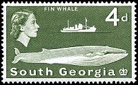
Postage stamps
A large source of income from abroad also comes from the issue of South Georgia and the South Sandwich Islands postage stamps which are produced in the UK.A reasonable issue policy (few sets of stamps are issued each year) along with attractive subject matter (especially whales) makes them popular with topical stamp collectors
Topical stamp collecting
Topical or thematic stamp collecting is the collecting of postage stamps relating to a particular subject or concept. Topics can be almost anything, from stamps on stamps, birds on stamps, to famous physicians, to the history of England.- Background :...
.
There are only four genuine first day cover sets from 16 March 1982 in existence. They were stamped at the South Georgia Post Office; all those in circulation were stamped elsewhere and sent out, but the only genuine ones were kept at the Post Office on South Georgia. These four sets were removed by a member of staff of the British Antarctic Survey in the few moments the Argentinians allowed them to gather their belongings. Everything else was burnt, but these four sets were saved and brought to the UK by Robert Headland, BAS.
Currency
The pound sterlingPound sterling
The pound sterling , commonly called the pound, is the official currency of the United Kingdom, its Crown Dependencies and the British Overseas Territories of South Georgia and the South Sandwich Islands, British Antarctic Territory and Tristan da Cunha. It is subdivided into 100 pence...
is the official currency of the islands, and the same notes and coins are used as in the United Kingdom. Since 2001, commemorative local coins have been issued for numismatists. For more information on British currency in the wider region see the Sterling Currency in the South Atlantic and the Antarctic.
Flora and fauna
- See also South Georgia Island nonmarine fauna.
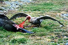 |
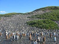 |
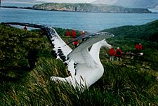 |
The parts of the islands that are not permanently covered in snow or ice are part of the Scotia Sea
Scotia Sea
The Scotia Sea is partly in the Southern Ocean and mostly in the South Atlantic Ocean.-Location and description:Habitually stormy and cold, the Scotia Sea is the area of water between Tierra del Fuego, South Georgia, South Sandwich Islands, South Orkney Islands and the Antarctic Peninsula, and...
Islands tundra
Tundra
In physical geography, tundra is a biome where the tree growth is hindered by low temperatures and short growing seasons. The term tundra comes through Russian тундра from the Kildin Sami word tūndâr "uplands," "treeless mountain tract." There are three types of tundra: Arctic tundra, alpine...
ecoregion
Ecoregion
An ecoregion , sometimes called a bioregion, is an ecologically and geographically defined area that is smaller than an ecozone and larger than an ecosystem. Ecoregions cover relatively large areas of land or water, and contain characteristic, geographically distinct assemblages of natural...
. Native vegetation on South Georgia is limited to grass
Grass
Grasses, or more technically graminoids, are monocotyledonous, usually herbaceous plants with narrow leaves growing from the base. They include the "true grasses", of the Poaceae family, as well as the sedges and the rushes . The true grasses include cereals, bamboo and the grasses of lawns ...
es, moss
Moss
Mosses are small, soft plants that are typically 1–10 cm tall, though some species are much larger. They commonly grow close together in clumps or mats in damp or shady locations. They do not have flowers or seeds, and their simple leaves cover the thin wiry stems...
es, lichen
Lichen
Lichens are composite organisms consisting of a symbiotic organism composed of a fungus with a photosynthetic partner , usually either a green alga or cyanobacterium...
s, fern
Fern
A fern is any one of a group of about 12,000 species of plants belonging to the botanical group known as Pteridophyta. Unlike mosses, they have xylem and phloem . They have stems, leaves, and roots like other vascular plants...
s and a few other small flowering plants. A number of other introduced species have become naturalised; many of these were introduced by whalers in cattle fodder, and some are considered invasive. There are no trees or shrubs.
South Georgia supports many sea birds, including albatross
Albatross
Albatrosses, of the biological family Diomedeidae, are large seabirds allied to the procellariids, storm-petrels and diving-petrels in the order Procellariiformes . They range widely in the Southern Ocean and the North Pacific...
, a large colony of King Penguins and penguin
Penguin
Penguins are a group of aquatic, flightless birds living almost exclusively in the southern hemisphere, especially in Antarctica. Highly adapted for life in the water, penguins have countershaded dark and white plumage, and their wings have become flippers...
s of various other species, along with petrel
Petrel
Petrels are tube-nosed seabirds in the bird order Procellariiformes. The common name does not indicate relationship beyond that point, as "petrels" occur in three of the four families within that group...
s, prions
Prion (bird)
The Prions are small petrels in the genera Pachyptila and Halobaena. They form one of the four groups within the Procellariidae , along with the gadfly petrels, shearwaters and fulmarine petrels....
, shags, skua
Skua
The skuas are a group of seabirds with about seven species forming the family Stercorariidae and the genus Stercorarius. The three smaller skuas are called jaegers in North America....
s, gull
Gull
Gulls are birds in the family Laridae. They are most closely related to the terns and only distantly related to auks, skimmers, and more distantly to the waders...
s and tern
Tern
Terns are seabirds in the family Sternidae, previously considered a subfamily of the gull family Laridae . They form a lineage with the gulls and skimmers which in turn is related to skuas and auks...
s. There is one songbird which is unique to the archipelago, the South Georgia Pipit
South Georgia Pipit
The South Georgia Pipit is a sparrow sized bird, only found on the South Georgia archipelago. It is the Antarctic's only song bird, and South Georgia's only passerine, and one of the few non-seabirds of the region....
, and a duck, the South Georgia Pintail
South Georgia Pintail
The South Georgia Pintail , also misleadingly known as the South Georgian Teal, is the nominate subspecies of the Yellow-billed Pintail , a duck in the dabbling duck subfamily Anatinae...
.
Seal
Pinniped
Pinnipeds or fin-footed mammals are a widely distributed and diverse group of semiaquatic marine mammals comprising the families Odobenidae , Otariidae , and Phocidae .-Overview: Pinnipeds are typically sleek-bodied and barrel-shaped...
s are frequent on the islands, and whale
Whale
Whale is the common name for various marine mammals of the order Cetacea. The term whale sometimes refers to all cetaceans, but more often it excludes dolphins and porpoises, which belong to suborder Odontoceti . This suborder also includes the sperm whale, killer whale, pilot whale, and beluga...
s may be seen in the surrounding waters. There are no native land mammals, though reindeer
Reindeer
The reindeer , also known as the caribou in North America, is a deer from the Arctic and Subarctic, including both resident and migratory populations. While overall widespread and numerous, some of its subspecies are rare and one has already gone extinct.Reindeer vary considerably in color and size...
, brown rat
Brown Rat
The brown rat, common rat, sewer rat, Hanover rat, Norway rat, Brown Norway rat, Norwegian rat, or wharf rat is one of the best known and most common rats....
s and mice
Mouse
A mouse is a small mammal belonging to the order of rodents. The best known mouse species is the common house mouse . It is also a popular pet. In some places, certain kinds of field mice are also common. This rodent is eaten by large birds such as hawks and eagles...
have been introduced through the activities of man. The latter have destroyed tens of millions of ground-nesting birds’ eggs and chicks, and scientists plan to eradicate the rats over four years starting 2011. It will be by far the largest rodent eradication attempt in the world to date.
Reindeer were introduced to South Georgia
Reindeer in South Georgia
Reindeer in South Georgia are an example of an animal which has been introduced outside its native range. The reindeer, a species of deer adapted to arctic and subarctic climates, was introduced to the subantarctic island of South Georgia by Norwegian whalers in the early 20th century...
in 1911 by Norwegian whalers for meat and for sport hunting. In February 2011 the authorities announced that, due to the reindeer's detrimental effect on native species and the threat of their spreading to presently pristine areas, a complete cull would take place, leading to the eradication of reindeer from the island.
The seas around South Georgia have a high level of biodiversity
Biodiversity
Biodiversity is the degree of variation of life forms within a given ecosystem, biome, or an entire planet. Biodiversity is a measure of the health of ecosystems. Biodiversity is in part a function of climate. In terrestrial habitats, tropical regions are typically rich whereas polar regions...
.In a recent study (2009–11), South Georgia has been discovered to contain one of the highest levels of biodiversity among all the ecosystems on Earth. The marine inhabitants endemic to this ecosystem outnumber (in respect to species) and surpass well-known regions such as the Galápagos or Ecuador in respect to biodiversity. This marine ecosystem
Ecosystem
An ecosystem is a biological environment consisting of all the organisms living in a particular area, as well as all the nonliving , physical components of the environment with which the organisms interact, such as air, soil, water and sunlight....
is thought to be vulnerable because its low temperatures mean that it can only repair itself very slowly.
Military
Falklands War
The Falklands War , also called the Falklands Conflict or Falklands Crisis, was fought in 1982 between Argentina and the United Kingdom over the disputed Falkland Islands and South Georgia and the South Sandwich Islands...
in 1982, a full-time British military presence was maintained at King Edward Point
King Edward Point
King Edward Point is a promontory and settlement with port facilities on the northeastern coast of the island of South Georgia. It is located at in Cumberland East Bay...
on South Georgia. This was scaled down during the 1990s, and the last detachment left South Georgia in March 2001, when the new station was built and occupied by the British Antarctic Survey
British Antarctic Survey
The British Antarctic Survey is the United Kingdom's national Antarctic operation and has an active role in Antarctic affairs. BAS is part of the Natural Environment Research Council and has over 400 staff. It operates five research stations, two ships and five aircraft in and around Antarctica....
.
The main British military facility in the region is at RAF Mount Pleasant
RAF Mount Pleasant
RAF Mount Pleasant is a military base for the Royal Air Force in the British Overseas Territory of the Falkland Islands. The facility is part of the British Forces South Atlantic Islands...
and the adjacent Mare Harbour
Mare Harbour
Mare Harbour Mare Harbour Mare Harbour (Spanish: Puerto Yegua is a small settlement on East Falkland, on Choiseul Sound. It is mostly used as a port facility and depot for RAF Mount Pleasant, as well as a deepwater port used by the Royal Navy ships patrolling the South Atlantic and Antarctica,...
naval base on East Falkland
East Falkland
East Falkland the largest of the Falkland Islands in the South Atlantic, has an area of and a coastline long. Most of the population of the Falklands live in East Falkland, almost all of them living in the northern half of the island...
. Other than that, a handful of British naval vessels patrol the region. They visit South Georgia a few times each year, sometimes deploying small patrols of infantry. Flights by RAF C-130 Hercules
C-130 Hercules
The Lockheed C-130 Hercules is a four-engine turboprop military transport aircraft designed and built originally by Lockheed, now Lockheed Martin. Capable of using unprepared runways for takeoffs and landings, the C-130 was originally designed as a troop, medical evacuation, and cargo transport...
and Vickers VC10
Vickers VC10
The Vickers VC10 is a long-range British airliner designed and built by Vickers-Armstrongs Ltd, and first flown in 1962. The airliner was designed to operate on long-distance routes with a high subsonic speed and also be capable of hot and high operations from African airports...
aircraft occasionally patrol the territory.
A Royal Navy destroyer or frigate and a Royal Fleet Auxiliary vessel carry out the Atlantic Patrol Task (South)
Standing Royal Navy deployments
Although the majority of the United Kingdom's Royal Navy fleet, unless required, remains training and exercising in and around Home Waters, the Navy has a number of standing commitments, including those held for contingent operations, to provide ships for various missions around the world:-Response...
mission in the surrounding area.
, the British Royal Navy ice patrol ship, operated in the South Georgia area during part of most southern summer seasons until her near loss in 2008. She carried out hydrological and mapping work as well as assisting with scientific fieldwork for the British Antarctic Survey, film and photographic units, and youth expedition group BSES Expeditions
BSES Expeditions
-History:BSES Expeditions is one of the longest-running and most distinctive youth development charities of its kind. Based at the Royal Geographical Society, BSES Expeditions was founded in 1932, by an original member of Captain Scott's final Antarctic Expedition of 1910-13, Surgeon Commander...
. It has been announced that Endurance is to be written off and a replacement vessel procured, an icebreaker to be named HMS Protector.
See also
- British Overseas TerritoriesBritish overseas territoriesThe British Overseas Territories are fourteen territories of the United Kingdom which, although they do not form part of the United Kingdom itself, fall under its jurisdiction. They are remnants of the British Empire that have not acquired independence or have voted to remain British territories...
- List of Antarctic and sub-Antarctic islands
- South Orkney IslandsSouth Orkney IslandsThe South Orkney Islands are a group of islands in the Southern Ocean, about north-east of the tip of the Antarctic Peninsula. They have a total area of about ....
- South Shetland IslandsSouth Shetland IslandsThe South Shetland Islands are a group of Antarctic islands, lying about north of the Antarctic Peninsula, with a total area of . By the Antarctic Treaty of 1959, the Islands' sovereignty is neither recognized nor disputed by the signatories and they are free for use by any signatory for...
External links
GovernmentGeneral information
Other