
Geography of the Interior United States
Encyclopedia

Geography
Geography is the science that studies the lands, features, inhabitants, and phenomena of Earth. A literal translation would be "to describe or write about the Earth". The first person to use the word "geography" was Eratosthenes...
of the United States
United States
The United States of America is a federal constitutional republic comprising fifty states and a federal district...
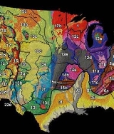
is split into several major physiographic divisions, three of which being the Laurentian Highlands, Interior Highlands and the Interior Plains (see subdivisions 1 and 11-15) lie in the interior of the U.S.
The Superior Upland
Laurentian Upland
The Laurentian Upland is a physiographic province which, when referred to as the "Laurentian Region," is recognized by Natural Resources Canada as one of five provinces of the larger Canadian Shield physiographic division...
which projects into the United States west and south of Lake Superior
Lake Superior
Lake Superior is the largest of the five traditionally-demarcated Great Lakes of North America. It is bounded to the north by the Canadian province of Ontario and the U.S. state of Minnesota, and to the south by the U.S. states of Wisconsin and Michigan. It is the largest freshwater lake in the...
. This upland, part of the Canadian Shield
Canadian Shield
The Canadian Shield, also called the Laurentian Plateau, or Bouclier Canadien , is a vast geological shield covered by a thin layer of soil that forms the nucleus of the North American or Laurentia craton. It is an area mostly composed of igneous rock which relates to its long volcanic history...
along with the Adirondacks, is a greatly deformed structure and is composed primarily of igneous and metamorphic crystalline rocks commonly associated with a rugged landscape. At some prehistoric period, this had a strong relief, but today the upland as a whole is gently rolling with the inter-streams surfaces being plateau-like in their evenness. Here they have altitudes of 1,400 to 2300 feet (701 m) in their higher areas, such as the Misquah Hills
Misquah Hills
The Misquah Hills are a range of large hills or small mountains in northeastern Minnesota, in the United States. They are located in or near the Boundary Waters Canoe Area Wilderness within Superior National Forest...
and Huron Mountains
Huron Mountains
The Huron Mountains are located in the Upper Peninsula of the U.S. state of Michigan, mostly in Marquette and Baraga counties, overlooking Lake Superior. Their highest peak is Mount Arvon which, at above sea level, is the highest point in the state of Michigan. Nearby Mt...
. In this province, we find a part of those ancient mountains regions that were initiated by crustal deformation and then reduced by a long continued erosion to a peneplain
Peneplain
A peneplain is a low-relief plain representing the final stage of fluvial erosion during times of extended tectonic stability. The existence of peneplains, and peneplanation as a geomorphological process, is not without controversy, due to a lack of contemporary examples and uncertainty in...
of modern relief. A peneplain with the occasional moderately high monadnock
Monadnock
A monadnock or inselberg is an isolated rock hill, knob, ridge, or small mountain that rises abruptly from a gently sloping or virtually level surrounding plain...
s left behind during the peneplanation of the rest of the surface. The erosion of the region must have been far advanced in prehistoric times, even practically completed, because the even peneplain surface is overlapped by fossiliferous marine strata from an early geological date, Cambrian
Cambrian
The Cambrian is the first geological period of the Paleozoic Era, lasting from Mya ; it is succeeded by the Ordovician. Its subdivisions, and indeed its base, are somewhat in flux. The period was established by Adam Sedgwick, who named it after Cambria, the Latin name for Wales, where Britain's...
. This shows that the depression of the region beneath an ancient sea took place after a long existence as dry land.
The extent of the submergence and the area over which the Palaeozoic strata were deposited are unknown. Because of the renewed elevation without deformation, erosion in later periods has stripped off an undetermined amount of the covering strata. The valleys by which the uplands are here and there trenched to moderate depth appear to be, in part at least, the work of streams that have been superposed upon the peneplain through the now removed cover of stratified rocks.
Glaciation has strongly scoured away the deeply-weathered soils that presumably existed here in preglacial time. It left behind firm and rugged ledges in the low hills and swells of the ground and spread an irregular drift cover over the lower parts, whereby the drainage is generally disordered being deposited in lakes and swamps and elsewhere rushing down rocky rapids.
Region of the Great Lakes
The Palaeozoic strata, already mentioned as lapping on the southern slope of the Superior Upland and around the western side of the Adirondack MountainsAdirondack Mountains
The Adirondack Mountains are a mountain range located in the northeastern part of New York, that runs through Clinton, Essex, Franklin, Fulton, Hamilton, Herkimer, Lewis, Saint Lawrence, Saratoga, Warren, and Washington counties....
, are but parts of a great area of similar strata hundreds of feet in thickness. These strata decline gently southward from the great upland of the Laurentian Highlands of eastern Canada. The visible upland area of today was but a small part of the primeval continent with the remainder of it still buried under a Palaeozoic cover. The visible part was the last part of the primeval continent to sink under the advancing Palaeozoic seas. When the upland and its overlap of stratified deposits were elevated again, the overlapping strata must have had the appearance of a coastal plain. Of course that was long ago; since then the strata have eroded substantially and today possess neither the area nor the smooth form of their initial extent. This district may be considered an ancient coastal plain. As is always the case in the broad denudation of the gently inclined strata of such plains, the weaker layers are worn down in sub-parallel belts of lower land between the upland and the belts of more resistant strata, which rise in uplands
Cuesta
In structural geology and geomorphology, a cuesta is a ridge formed by gently tilted sedimentary rock strata in a homoclinal structure. Cuestas have a steep slope, where the rock layers are exposed on their edges, called an escarpment or, if more steep, a cliff...
.
Few better illustrations of this type of forms are to be found than that presented in the district of the Great Lakes
Great Lakes
The Great Lakes are a collection of freshwater lakes located in northeastern North America, on the Canada – United States border. Consisting of Lakes Superior, Michigan, Huron, Erie, and Ontario, they form the largest group of freshwater lakes on Earth by total surface, coming in second by volume...
. The chief upland belt or escarpment
Escarpment
An escarpment is a steep slope or long cliff that occurs from erosion or faulting and separates two relatively level areas of differing elevations.-Description and variants:...
is formed by the firm Niagara limestone/dolostone, which takes its name from the gorge and falls cut through the upland by the Niagara River
Niagara River
The Niagara River flows north from Lake Erie to Lake Ontario. It forms part of the border between the Province of Ontario in Canada and New York State in the United States. There are differing theories as to the origin of the name of the river...
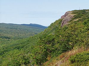
. As in all such forms, the Niagara Escarpment
Niagara Escarpment
The Niagara Escarpment is a long escarpment, or cuesta, in the United States and Canada that runs westward from New York State, through Ontario, Michigan, Wisconsin and Illinois...
has a relatively strong slope or infacing escarpment on the side towards the upland, and a long gentle slope
Dip slope
A dip slope is a geological formation often created by erosion of tilted strata. Dip slopes are found on homoclinal ridges with one side that is steep and irregular and another side, the dip slope, that is generally planar with a dip parallel to the bedding...
on the other side. Its relief is seldom more than 200 or 300 feet (91.4 m) and is generally small. Its continuity and its contrast with the associated lowlands on the underlying and overlying weak strata suffice to make it an important feature. The escarpment would lie straight east-west if the slant of the strata were uniformly to the south. However, the strata are somewhat warped and so the escarpment's course is strongly convex to the north in
the middle, gently convex to the south at either end.
The escarpment begins where its determining limestone
Limestone
Limestone is a sedimentary rock composed largely of the minerals calcite and aragonite, which are different crystal forms of calcium carbonate . Many limestones are composed from skeletal fragments of marine organisms such as coral or foraminifera....
/dolostone
Dolostone
Dolostone or dolomite rock is a sedimentary carbonate rock that contains a high percentage of the mineral dolomite. In old U.S.G.S. publications it was referred to as magnesian limestone. Most dolostone formed as a magnesium replacement of limestone or lime mud prior to lithification. It is...
begins, in west-central New York
New York
New York is a state in the Northeastern region of the United States. It is the nation's third most populous state. New York is bordered by New Jersey and Pennsylvania to the south, and by Connecticut, Massachusetts and Vermont to the east...
. There, it separates the lowlands that contain Lake Ontario
Lake Ontario
Lake Ontario is one of the five Great Lakes of North America. It is bounded on the north and southwest by the Canadian province of Ontario, and on the south by the American state of New York. Ontario, Canada's most populous province, was named for the lake. In the Wyandot language, ontarío means...
from Lake Erie
Lake Erie
Lake Erie is the fourth largest lake of the five Great Lakes in North America, and the tenth largest globally. It is the southernmost, shallowest, and smallest by volume of the Great Lakes and therefore also has the shortest average water residence time. It is bounded on the north by the...
. It curves to the northwest through the Ontario province to the island belt that divides the Georgian Bay
Georgian Bay
Georgian Bay is a large bay of Lake Huron, located entirely within Ontario, Canada...
from Lake Huron
Lake Huron
Lake Huron is one of the five Great Lakes of North America. Hydrologically, it comprises the larger portion of Lake Michigan-Huron. It is bounded on the east by the Canadian province of Ontario and on the west by the state of Michigan in the United States...
. From there, it heads westward through the land-arm between Lake Superior
Lake Superior
Lake Superior is the largest of the five traditionally-demarcated Great Lakes of North America. It is bounded to the north by the Canadian province of Ontario and the U.S. state of Minnesota, and to the south by the U.S. states of Wisconsin and Michigan. It is the largest freshwater lake in the...
and Lake Michigan
Lake Michigan
Lake Michigan is one of the five Great Lakes of North America and the only one located entirely within the United States. It is the second largest of the Great Lakes by volume and the third largest by surface area, after Lake Superior and Lake Huron...
and southwestward into the narrow points dividing Green Bay from Lake Michigan. Finally, it fades away with the thinning out of the limestone and is hardly traceable across the Mississippi River
Mississippi River
The Mississippi River is the largest river system in North America. Flowing entirely in the United States, this river rises in western Minnesota and meanders slowly southwards for to the Mississippi River Delta at the Gulf of Mexico. With its many tributaries, the Mississippi's watershed drains...
.
The arrangement of the Great Lakes closely matches the course of the lowlands worn on the two belts of weaker strata on either side of the Niagara escarpment. Lake Ontario, Georgian Bay and Green Bay occupy depressions in the lowland on the inner side of the escarpment. Lake Erie, Lake Huron and Lake Michigan lie in depressions in the lowland on the outer side. When the two lowlands are traced eastward, they become confluent after the Niagara limestone has faded away in central New York, and the single lowland is continued under the name of the Mohawk Valley
Mohawk Valley
The Mohawk Valley region of the U.S. state of New York is the area surrounding the Mohawk River, sandwiched between the Adirondack Mountains and Catskill Mountains....
. This is an east-west longitudinal depression that has been eroded on a belt of relatively weak strata between the resistant crystalline rocks of the Adirondacks on the north and the northern escarpment of the Appalachian plateau
Appalachian Plateau
The Appalachian Plateau is the western part of the Appalachian mountains, stretching from New York and Alabama. The plateau is a second level United States physiographic region....
(Catskills-Helderbergs) on the south. Early in U.S. history, this provided a vital economic route between the Atlantic seaports and the U.S. interior.
In Wisconsin
Wisconsin
Wisconsin is a U.S. state located in the north-central United States and is part of the Midwest. It is bordered by Minnesota to the west, Iowa to the southwest, Illinois to the south, Lake Michigan to the east, Michigan to the northeast, and Lake Superior to the north. Wisconsin's capital is...
, the inner lowland has an interesting feature. It is a knob of resistant quartzites, known as Baraboo Ridge, rising from the buried upland floor through the partly denuded cover of lower Palaeozoic strata. This knob or ridge can be thought of as an ancient physiographic fossil, as it is an ancient monadnock having been preserved from destructive attacks of weather by burial under sea-floor deposits. It has been recently re-exposed through the erosion of its cover.
The occurrence of the lake basins in the lowland belts on either side of the Niagara escarpment is an abnormal feature. Ordinary erosion does not explain it. Glacial erosion has formed them through the glacial drift obstructing the normal outlet valleys and to crustal warping in connection with or independent of the glacial sheet.
Lake Superior
Lake Superior
Lake Superior is the largest of the five traditionally-demarcated Great Lakes of North America. It is bounded to the north by the Canadian province of Ontario and the U.S. state of Minnesota, and to the south by the U.S. states of Wisconsin and Michigan. It is the largest freshwater lake in the...
is unlike the other lakes. The greater part of its basin occupies a depression in the upland area, independent of the overlap of Palaeozoic strata. The western half of the basin occupies a trough of synclinal
Syncline
In structural geology, a syncline is a fold, with younger layers closer to the center of the structure. A synclinorium is a large syncline with superimposed smaller folds. Synclines are typically a downward fold, termed a synformal syncline In structural geology, a syncline is a fold, with younger...
structure. The Great Lakes are peculiar in receiving the drainage of but a small peripheral land area, enclosed by an ill-defined water-parting from the rivers that run to Hudson Bay
Hudson Bay
Hudson Bay , sometimes called Hudson's Bay, is a large body of saltwater in northeastern Canada. It drains a very large area, about , that includes parts of Ontario, Quebec, Saskatchewan, Alberta, most of Manitoba, southeastern Nunavut, as well as parts of North Dakota, South Dakota, Minnesota,...
or the Gulf of Saint Lawrence
Gulf of Saint Lawrence
The Gulf of Saint Lawrence , the world's largest estuary, is the outlet of North America's Great Lakes via the Saint Lawrence River into the Atlantic Ocean...
on the north and to the Gulf of Mexico
Gulf of Mexico
The Gulf of Mexico is a partially landlocked ocean basin largely surrounded by the North American continent and the island of Cuba. It is bounded on the northeast, north and northwest by the Gulf Coast of the United States, on the southwest and south by Mexico, and on the southeast by Cuba. In...
on the south.
.jpg)
- Lake Michigan
- Lake Huron
- Lake Erie
Lake Michigan and Lake Huron are connected by the Straits of Mackinac
Straits of Mackinac
The Straits of Mackinac is the strip of water that connects two of the Great Lakes, Lake Michigan and Lake Huron, and separates the Lower Peninsula of Michigan from the Upper Peninsula of Michigan. It is a shipping lane providing passage for raw materials and finished goods, connecting, for...
with the Mackinac Bridge
Mackinac Bridge
The Mackinac Bridge is a suspension bridge spanning the Straits of Mackinac to connect the non-contiguous Upper and Lower peninsulas of the U.S. state of Michigan. Opened in 1957, the bridge is the third longest in total suspension in the world and the longest suspension bridge between anchorages...
spanning the straits. Lake Huron and Lake Erie are connected by the St. Clair River
St. Clair River
The St. Clair River is a river in central North America which drains Lake Huron into Lake St Clair, forming part of the international boundary between the Canadian province of Ontario and the U.S. state of Michigan...
and Detroit River
Detroit River
The Detroit River is a strait in the Great Lakes system. The name comes from the French Rivière du Détroit, which translates literally as "River of the Strait". The Detroit River has served an important role in the history of Detroit and is one of the busiest waterways in the world. The river...
, with the small Lake St. Clair
Lake Saint Clair (North America)
Lake St. Clair is a fresh-water lake named after Clare of Assisi that lies between the Province of Ontario and the State of Michigan, and its midline also forms the boundary between Canada and the United States of America. Lake St. Clair includes the Anchor Bay along the Metro Detroit coastline...
between them. The land northeast of the rivers is undergoing a slow elevation. The Niagara River
Niagara River
The Niagara River flows north from Lake Erie to Lake Ontario. It forms part of the border between the Province of Ontario in Canada and New York State in the United States. There are differing theories as to the origin of the name of the river...
connecting Lake Erie and Lake Ontario, with a fall of 326 feet (99.4 m) (160 feet (48.8 m) at the cataract) in 30 miles (48.3 km), is of very recent origin, as an older river would have a mature valley. The original valley that is thought to have connected the two depressions through the Niagara Escarpment is thought to have been at the present route of the Welland Canal
Welland Canal
The Welland Canal is a ship canal in Canada that extends from Port Weller, Ontario, on Lake Ontario, to Port Colborne, Ontario, on Lake Erie. As a part of the St...
, and to have been completely filled with glacial drift
Moraine
A moraine is any glacially formed accumulation of unconsolidated glacial debris which can occur in currently glaciated and formerly glaciated regions, such as those areas acted upon by a past glacial maximum. This debris may have been plucked off a valley floor as a glacier advanced or it may have...
. The same is true for the St. Lawrence
Saint Lawrence River
The Saint Lawrence is a large river flowing approximately from southwest to northeast in the middle latitudes of North America, connecting the Great Lakes with the Atlantic Ocean. It is the primary drainage conveyor of the Great Lakes Basin...
, where there may not have been an original valley. The Ontarian River
Ontarian River
The Ontarian River is the term used for the pre-glacial river that began the creation of the valley in Silurian age shales and limestones now occupied by Lake Ontario. The valley was greatly deepened by glacial action during the Ice age....
that was a precursor to Lake Ontario is thought to have drained westward, and the St. Lawrence drainage to have been created by subsidence due to the weight of the ice sheet.
The Prairie States
The originally treeless prairies of the upper Mississippi basin began in IndianaIndiana
Indiana is a US state, admitted to the United States as the 19th on December 11, 1816. It is located in the Midwestern United States and Great Lakes Region. With 6,483,802 residents, the state is ranked 15th in population and 16th in population density. Indiana is ranked 38th in land area and is...
and extended westward and north-westward until they merged with the drier region known as the Great Plains
Great Plains
The Great Plains are a broad expanse of flat land, much of it covered in prairie, steppe and grassland, which lies west of the Mississippi River and east of the Rocky Mountains in the United States and Canada. This area covers parts of the U.S...
. An eastward extension of the same region, originally tree-covered, extended to central Ohio
Ohio
Ohio is a Midwestern state in the United States. The 34th largest state by area in the U.S.,it is the 7th‑most populous with over 11.5 million residents, containing several major American cities and seven metropolitan areas with populations of 500,000 or more.The state's capital is Columbus...
. Thus the prairies generally lie between the Ohio
Ohio River
The Ohio River is the largest tributary, by volume, of the Mississippi River. At the confluence, the Ohio is even bigger than the Mississippi and, thus, is hydrologically the main stream of the whole river system, including the Allegheny River further upstream...
and Missouri
Missouri River
The Missouri River flows through the central United States, and is a tributary of the Mississippi River. It is the longest river in North America and drains the third largest area, though only the thirteenth largest by discharge. The Missouri's watershed encompasses most of the American Great...
rivers on the south and the Great Lakes on the north. The prairies are a contribution of the glacial period. They consist for the most part of glacial drift, deposited unconformably on an underlying rock surface of moderate or small relief. Here, the rocks are an extension of the same stratified Palaeozoic formations already described as occurring in the Appalachian region and around the Great Lakes
Great Lakes
The Great Lakes are a collection of freshwater lakes located in northeastern North America, on the Canada – United States border. Consisting of Lakes Superior, Michigan, Huron, Erie, and Ontario, they form the largest group of freshwater lakes on Earth by total surface, coming in second by volume...
. They are usually fine-textured limestones and shales, lying horizontal. The moderate or small relief that they were given by mature preglacial erosion is now buried under the drift.
The greatest area of the prairies, from Indiana
Indiana
Indiana is a US state, admitted to the United States as the 19th on December 11, 1816. It is located in the Midwestern United States and Great Lakes Region. With 6,483,802 residents, the state is ranked 15th in population and 16th in population density. Indiana is ranked 38th in land area and is...
to North Dakota
North Dakota
North Dakota is a state located in the Midwestern region of the United States of America, along the Canadian border. The state is bordered by Canada to the north, Minnesota to the east, South Dakota to the south and Montana to the west. North Dakota is the 19th-largest state by area in the U.S....
, consists of till plains, that is, sheets of unstratified drift. These plains are 30, 50 or even 100 ft (up to 30 m) thick covering the underlying rock surface for thousands of square miles except where postglacial stream erosion has locally laid it bare. The plains have an extraordinarily even surface. The till is presumably made in part of preglacial soils, but it is more largely composed of rock waste mechanically transported by the creeping ice sheets. Although the crystalline rocks from Canada
Canada
Canada is a North American country consisting of ten provinces and three territories. Located in the northern part of the continent, it extends from the Atlantic Ocean in the east to the Pacific Ocean in the west, and northward into the Arctic Ocean...
and some of the more resistant stratified rocks south of the Great Lakes occur as boulders and stones, a great part of the till
Till
thumb|right|Closeup of glacial till. Note that the larger grains in the till are completely surrounded by the matrix of finer material , and this characteristic, known as matrix support, is diagnostic of till....
has been crushed and ground to a clayey texture. The till plains, although sweeping in broad swells of slowly changing altitude, often appear level to the eye with a view stretching to the horizon. Here and there, faint depressions occur, occupied by marshy sloughs, or floored with a rich black soil of postglacial origin. It is thus by sub-glacial aggradation that the prairies have been levelled up to a smooth surface, in contrast to the higher and non-glaciated hilly country just to the south.
The great ice sheets formed terminal moraine
Moraine
A moraine is any glacially formed accumulation of unconsolidated glacial debris which can occur in currently glaciated and formerly glaciated regions, such as those areas acted upon by a past glacial maximum. This debris may have been plucked off a valley floor as a glacier advanced or it may have...
s around their border at various end stages. However, the morainic belts are of small relief in comparison to the great area of the ice. They rise gently from the till plains to a height of 50, 100 or more feet. They may be one, two or three miles (5 km) wide and their hilly surface, dotted over with boulders, contains many small lakes in basins or hollows, instead of streams in valleys. The morainic belts are arranged in groups of concentric loops, convex southward, because the ice sheets advanced in lobes along the lowlands of the Great Lakes. Neighboring morainic loops join each other in re-entrants (north-pointing cusps), where two adjacent glacial lobes came together and formed their moraines in largest volume. The moraines are of too small relief to be shown on any maps except of the largest scale. Small as they are, they are the chief relief of the prairie states, and, in association with the nearly imperceptible slopes of the till plains, they determine the course of many streams and rivers, which as a whole are consequent upon the surface form of the glacial deposits.
The complexity of the glacial period and its subdivision into several glacial epochs, separated by interglacial epochs of considerable length (certainly longer than the postglacial epoch) has a structural consequence in the superposition of successive till sheets, alternating with non-glacial deposits. It also has a physiographic consequence in the very different amount of normal postglacial erosion suffered by the different parts of the glacial deposits. The southernmost drift sheets, as in southern Iowa
Iowa
Iowa is a state located in the Midwestern United States, an area often referred to as the "American Heartland". It derives its name from the Ioway people, one of the many American Indian tribes that occupied the state at the time of European exploration. Iowa was a part of the French colony of New...
and northern Missouri
Missouri
Missouri is a US state located in the Midwestern United States, bordered by Iowa, Illinois, Kentucky, Tennessee, Arkansas, Oklahoma, Kansas and Nebraska. With a 2010 population of 5,988,927, Missouri is the 18th most populous state in the nation and the fifth most populous in the Midwest. It...
, have lost their initially plain surface and are now maturely dissected into gracefully rolling forms. Here, the valleys of even the small streams are well opened and graded, and marshes and lakes are rare. These sheets are of early Pleistocene
Pleistocene
The Pleistocene is the epoch from 2,588,000 to 11,700 years BP that spans the world's recent period of repeated glaciations. The name pleistocene is derived from the Greek and ....
origin. Nearer the Great Lakes, the till sheets are trenched only by the narrow valleys of the large streams. Marshy sloughs still occupy the faint depressions in the till plains and the associated moraines have abundant small lakes in their undrained hollows. These drift sheets are of late Pleistocene origin.
When the ice sheets extended to the land sloping southward to the Ohio River, Mississippi River
Mississippi River
The Mississippi River is the largest river system in North America. Flowing entirely in the United States, this river rises in western Minnesota and meanders slowly southwards for to the Mississippi River Delta at the Gulf of Mexico. With its many tributaries, the Mississippi's watershed drains...
and Missouri River, the drift-laden streams flowed freely away from the ice border. As the streams escaped from their subglacial channels, they spread into broader channels and deposited some of their load and thus aggraded their courses. Local sheets or aprons of gravel and sand are spread more or less abundantly along the outer side of the morainic belts. Long trains of gravel and sands clog the valleys that lead southward from the glaciated to the non-glaciated area. Later, when the ice retreated farther and the unloaded streams returned to their earlier degrading habit, they more or less completely scoured out the valley deposits, the remains of which are now seen in terraces on either side of the present flood plains.
When the ice of the last glacial epoch had retreated so far that its front border lay on a northward slope, belonging to the drainage area of the Great Lakes, bodies of water accumulated in front of the ice margin, forming glacio-marginal lakes. The lakes were small at first, and each had its own outlet at the lowest depression of land to the south. As the ice melted further back, neighboring lakes became confluent at the level of the lowest outlet of the group. The outflowing streams grew in the same proportion and eroded a broad channel across the height of land and far down stream, while the lake waters built sand reefs or carved shore cliffs along their margin, and laid down sheets of clay on their floors. All of these features are easily recognized in the prairie region. The present site of Chicago
Chicago
Chicago is the largest city in the US state of Illinois. With nearly 2.7 million residents, it is the most populous city in the Midwestern United States and the third most populous in the US, after New York City and Los Angeles...
was determined by an Indian portage or carry across the low divide between Lake Michigan
Lake Michigan
Lake Michigan is one of the five Great Lakes of North America and the only one located entirely within the United States. It is the second largest of the Great Lakes by volume and the third largest by surface area, after Lake Superior and Lake Huron...
and the headwaters of the Illinois River
Illinois River
The Illinois River is a principal tributary of the Mississippi River, approximately long, in the State of Illinois. The river drains a large section of central Illinois, with a drainage basin of . This river was important among Native Americans and early French traders as the principal water route...
. This divide lies on the floor of the former outlet channel of the glacial Lake Michigan. Corresponding outlets are known for Lake Erie
Lake Erie
Lake Erie is the fourth largest lake of the five Great Lakes in North America, and the tenth largest globally. It is the southernmost, shallowest, and smallest by volume of the Great Lakes and therefore also has the shortest average water residence time. It is bounded on the north by the...
, Lake Huron
Lake Huron
Lake Huron is one of the five Great Lakes of North America. Hydrologically, it comprises the larger portion of Lake Michigan-Huron. It is bounded on the east by the Canadian province of Ontario and on the west by the state of Michigan in the United States...
and Lake Superior
Lake Superior
Lake Superior is the largest of the five traditionally-demarcated Great Lakes of North America. It is bounded to the north by the Canadian province of Ontario and the U.S. state of Minnesota, and to the south by the U.S. states of Wisconsin and Michigan. It is the largest freshwater lake in the...
. A very large sheet of water, named Lake Agassiz
Lake Agassiz
Lake Agassiz was an immense glacial lake located in the center of North America. Fed by glacial runoff at the end of the last glacial period, its area was larger than all of the modern Great Lakes combined, and it held more water than contained by all lakes in the world today.-Conception:First...
, once overspread a broad till plain in northern Minnesota
Minnesota
Minnesota is a U.S. state located in the Midwestern United States. The twelfth largest state of the U.S., it is the twenty-first most populous, with 5.3 million residents. Minnesota was carved out of the eastern half of the Minnesota Territory and admitted to the Union as the thirty-second state...
and North Dakota. The outlet of this glacial lake, called river Warren, eroded a large channel in which the Minnesota River
Minnesota River
The Minnesota River is a tributary of the Mississippi River, approximately 332 miles long, in the U.S. state of Minnesota. It drains a watershed of nearly , in Minnesota and about in South Dakota and Iowa....
evident today. The Red River of the North
Red River of the North
The Red River is a North American river. Originating at the confluence of the Bois de Sioux and Otter Tail rivers in the United States, it flows northward through the Red River Valley and forms the border between the U.S. states of Minnesota and North Dakota before continuing into Manitoba, Canada...
flows northward through a plain formerly covered by Lake Agassiz.
Certain extraordinary features were produced when the retreat of the ice sheet had progressed so far as to open an eastward outlet for the marginal lakes. This outlet occurred along the depression between the northward slope of the Appalachian plateau in west-central New York and the southward slope of the melting ice sheet. When this eastward outlet came to be lower than the south-westward outlet across the height of land to the Ohio or Mississippi river, the discharge of the marginal lakes was changed from the Mississippi system to the Hudson
Hudson River
The Hudson is a river that flows from north to south through eastern New York. The highest official source is at Lake Tear of the Clouds, on the slopes of Mount Marcy in the Adirondack Mountains. The river itself officially begins in Henderson Lake in Newcomb, New York...
system. Many well-defined channels, cutting across the north-sloping spurs of the plateau in the neighborhood of Syracuse, New York
Syracuse, New York
Syracuse is a city in and the county seat of Onondaga County, New York, United States, the largest U.S. city with the name "Syracuse", and the fifth most populous city in the state. At the 2010 census, the city population was 145,170, and its metropolitan area had a population of 742,603...
, mark the temporary paths of the ice-bordered outlet river. Successive channels are found at lower and lower levels on the plateau slope, indicating the successive courses taken by the lake outlet as the ice melted farther and farther back. On some of these channels, deep gorges were eroded heading in temporary cataracts which exceeded Niagara in height but not in breadth. The pools excavated by the plunging waters at the head of the gorges are now occupied by little lakes. The most significant stage in this series of changes occurred when the glacio-marginal lake waters were lowered so that the long escarpment of Niagara limestone was laid bare in western New York. The previously confluent waters were then divided into two lakes. The higher one, Lake Erie
Lake Erie
Lake Erie is the fourth largest lake of the five Great Lakes in North America, and the tenth largest globally. It is the southernmost, shallowest, and smallest by volume of the Great Lakes and therefore also has the shortest average water residence time. It is bounded on the north by the...
, supplied the outflowing Niagara River
Niagara River
The Niagara River flows north from Lake Erie to Lake Ontario. It forms part of the border between the Province of Ontario in Canada and New York State in the United States. There are differing theories as to the origin of the name of the river...
, which poured its waters down the escarpment to the lower, Lake Ontario
Lake Ontario
Lake Ontario is one of the five Great Lakes of North America. It is bounded on the north and southwest by the Canadian province of Ontario, and on the south by the American state of New York. Ontario, Canada's most populous province, was named for the lake. In the Wyandot language, ontarío means...
. This gave rise to Niagara Falls
Niagara Falls
The Niagara Falls, located on the Niagara River draining Lake Erie into Lake Ontario, is the collective name for the Horseshoe Falls and the adjacent American Falls along with the comparatively small Bridal Veil Falls, which combined form the highest flow rate of any waterfalls in the world and has...
. Lake Ontario's outlet for a time ran down the Mohawk Valley
Mohawk Valley
The Mohawk Valley region of the U.S. state of New York is the area surrounding the Mohawk River, sandwiched between the Adirondack Mountains and Catskill Mountains....
to the Hudson River
Hudson River
The Hudson is a river that flows from north to south through eastern New York. The highest official source is at Lake Tear of the Clouds, on the slopes of Mount Marcy in the Adirondack Mountains. The river itself officially begins in Henderson Lake in Newcomb, New York...
. At this higher elevation it was known as Lake Iroquois
Glacial Lake Iroquois
Glacial Lake Iroquois was a prehistoric proglacial lake that existed at the end of the last ice age approximately 13,000 years ago.The lake was essentially an enlargement of the present Lake Ontario that formed because the St. Lawrence River downstream from the lake was blocked by the ice sheet...
. When the ice melted from the northeastern end of the lake, it dropped to a lower level, and drained through the St. Lawrence area. This created a lower base level
Base level
The base level of a river or stream is the lowest point to which it can flow, often referred to as the 'mouth' of the river. For large rivers, sea level is usually the base level, but a large river or lake is likewise the base level for tributary streams...
for the Niagara River, increasing its erosive capacity.
In certain districts, the subglacial till was not spread out in a smooth plain, but accumulated in elliptical mounds, 100–200 feet. high and 0.5 to 1 mile (0.8 to 1.6 km) long with axes parallel to the direction of the ice motion as indicated by striae on the underlying rock floor. These hills are known by the Irish name, drumlin
Drumlin
A drumlin, from the Irish word droimnín , first recorded in 1833, is an elongated whale-shaped hill formed by glacial ice acting on underlying unconsolidated till or ground moraine.-Drumlin formation:...
s, used for similar hills in north-western Ireland
Ireland
Ireland is an island to the northwest of continental Europe. It is the third-largest island in Europe and the twentieth-largest island on Earth...
. The most remarkable groups of drumlins occur in western New York
New York
New York is a state in the Northeastern region of the United States. It is the nation's third most populous state. New York is bordered by New Jersey and Pennsylvania to the south, and by Connecticut, Massachusetts and Vermont to the east...
, where their number is estimated at over 6,000, and in southern Wisconsin, where it is placed at 5,000. They completely dominate the topography of their districts.
A curious deposit of an impalpably fine and unstratified silt, known by the German
German language
German is a West Germanic language, related to and classified alongside English and Dutch. With an estimated 90 – 98 million native speakers, German is one of the world's major languages and is the most widely-spoken first language in the European Union....
name bess (or loess
Loess
Loess is an aeolian sediment formed by the accumulation of wind-blown silt, typically in the 20–50 micrometre size range, twenty percent or less clay and the balance equal parts sand and silt that are loosely cemented by calcium carbonate...
), lies on the older drift sheets near the larger river courses of the upper Mississippi basin. It attains a thickness of 20 ft (6 m) or more near the rivers and gradually fades away at a distance of ten or more miles (16 or more km) on either side. It contains land shells, and hence cannot be attributed to marine or lacustrine submergence. The best explanation is that, during certain phases of the glacial period, it was carried as dust by the winds from the flood plains of aggrading rivers, and slowly deposited on the neighboring grass-covered plains. The glacial and eolian origin of this sediment is evidenced by the angularity of its grains (a bank of it will stand without slumping for years), whereas, if it had been transported significantly by water, the grains would have been rounded and polished. Loess is parent material for an extremely fertile, but droughty soil.
Southwestern Wisconsin
Wisconsin
Wisconsin is a U.S. state located in the north-central United States and is part of the Midwest. It is bordered by Minnesota to the west, Iowa to the southwest, Illinois to the south, Lake Michigan to the east, Michigan to the northeast, and Lake Superior to the north. Wisconsin's capital is...
and parts of the adjacent states of Illinois
Illinois
Illinois is the fifth-most populous state of the United States of America, and is often noted for being a microcosm of the entire country. With Chicago in the northeast, small industrial cities and great agricultural productivity in central and northern Illinois, and natural resources like coal,...
, Iowa
Iowa
Iowa is a state located in the Midwestern United States, an area often referred to as the "American Heartland". It derives its name from the Ioway people, one of the many American Indian tribes that occupied the state at the time of European exploration. Iowa was a part of the French colony of New...
and Minnesota
Minnesota
Minnesota is a U.S. state located in the Midwestern United States. The twelfth largest state of the U.S., it is the twenty-first most populous, with 5.3 million residents. Minnesota was carved out of the eastern half of the Minnesota Territory and admitted to the Union as the thirty-second state...
are known as the driftless zone, because, although bordered by drift sheets and moraines, it is free from glacial deposits. It must therefore have been a sort of oasis, when the ice sheets from the north advanced past it on the east and west and joined around its southern border. The reason for this exemption from glaciation is the converse of that for the southward convexity of the morainic loops. For while they mark the paths of greatest glacial advance along lowland troughs (lake basins), the driftless zone is a district protected from ice invasion by reason of the obstruction which the highlands of northern Wisconsin and Michigan (part of the Superior upland) offered to glacial advance.
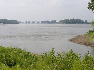
The course of the upper Mississippi River
Mississippi River
The Mississippi River is the largest river system in North America. Flowing entirely in the United States, this river rises in western Minnesota and meanders slowly southwards for to the Mississippi River Delta at the Gulf of Mexico. With its many tributaries, the Mississippi's watershed drains...
is largely consequent upon glacial deposits. Its sources are in the morainic lakes in northern Minnesota
Minnesota
Minnesota is a U.S. state located in the Midwestern United States. The twelfth largest state of the U.S., it is the twenty-first most populous, with 5.3 million residents. Minnesota was carved out of the eastern half of the Minnesota Territory and admitted to the Union as the thirty-second state...
. The drift deposits thereabouts are so heavy that the present divides between the drainage basins of Hudson Bay
Hudson Bay
Hudson Bay , sometimes called Hudson's Bay, is a large body of saltwater in northeastern Canada. It drains a very large area, about , that includes parts of Ontario, Quebec, Saskatchewan, Alberta, most of Manitoba, southeastern Nunavut, as well as parts of North Dakota, South Dakota, Minnesota,...
, Lake Superior
Lake Superior
Lake Superior is the largest of the five traditionally-demarcated Great Lakes of North America. It is bounded to the north by the Canadian province of Ontario and the U.S. state of Minnesota, and to the south by the U.S. states of Wisconsin and Michigan. It is the largest freshwater lake in the...
and the Gulf of Mexico
Gulf of Mexico
The Gulf of Mexico is a partially landlocked ocean basin largely surrounded by the North American continent and the island of Cuba. It is bounded on the northeast, north and northwest by the Gulf Coast of the United States, on the southwest and south by Mexico, and on the southeast by Cuba. In...
evidently stand in no very definite relation to the preglacial divides. The course of the Mississippi through Minnesota is largely guided by the form of the drift cover. Several rapids and the Saint Anthony Falls
Saint Anthony Falls
Saint Anthony Falls, or the Falls of Saint Anthony, located northeast of downtown Minneapolis, Minnesota, was the only natural major waterfall on the Upper Mississippi River. The natural falls was replaced by a concrete overflow spillway after it partially collapsed in 1869...
(determining the site of Minneapolis
Minneapolis, Minnesota
Minneapolis , nicknamed "City of Lakes" and the "Mill City," is the county seat of Hennepin County, the largest city in the U.S. state of Minnesota, and the 48th largest in the United States...
) are signs of immaturity, resulting from superposition through the drift on the under rock. Farther south, as far as the entrance of the Ohio River
Ohio River
The Ohio River is the largest tributary, by volume, of the Mississippi River. At the confluence, the Ohio is even bigger than the Mississippi and, thus, is hydrologically the main stream of the whole river system, including the Allegheny River further upstream...
, the Mississippi follows a rock-walled valley 300 to 400 ft (90 to 120 m) deep, with a flood-plain 2 to 4 mi (3 to 7 km) wide. This valley seems to represent the path of an enlarged early-glacial Mississippi, when much precipitation that is today discharged to Hudson Bay and the Gulf of St Lawrence was delivered to the Gulf of Mexico, for the curves of the present river are of distinctly smaller radii than the curves of the valley. Lake Pepin
Lake Pepin
Lake Pepin is a naturally occurring lake, and the widest naturally occurring part of the Mississippi River, located approximately 60 miles downstream from Saint Paul, Minnesota. It is a widening of the river on the border between Minnesota and Wisconsin. The formation of the lake was caused by the...
(30 mi [50 km] below St. Paul
Saint Paul, Minnesota
Saint Paul is the capital and second-most populous city of the U.S. state of Minnesota. The city lies mostly on the east bank of the Mississippi River in the area surrounding its point of confluence with the Minnesota River, and adjoins Minneapolis, the state's largest city...
), a picturesque expansion of the river across its flood-plain, is due to the aggradation of the valley floor where the Chippewa River
Chippewa River (Wisconsin)
The Chippewa River in Wisconsin flows approximately 183 miles through west-central and northwestern Wisconsin. It was once navigable for approximately 50 miles of its length, from the Mississippi River, by Durand, northeast to Eau Claire. Its catchment defines a portion of the northern boundary...
, coming from the northeast, brought an overload of fluvio-glacial drift. Hence even the father of waters, like so many other rivers in the Northern states, owes many of its features more or less directly to glacial action.
The fertility of the prairies is a natural consequence of their origin. During the mechanical transportation of the till no vegetation was present to remove the minerals essential to plant growth, as is the case in the soils of normally weathered and dissected peneplains. The soil is similar to the Appalachian piedmont which though not exhausted by the primeval forest cover, are by no means so rich as the till sheets of the prairies. Moreover, whatever the rocky understructure, the till soil has been averaged by a thorough mechanical mixture of rock grindings. Hence the prairies are continuously fertile for scores of miles together. The true prairies were once covered with a rich growth of natural grass and annual flowering plants, but today are covered with farms.
The Gulf Coastal Plain
The westward extension of the Atlantic Coastal PlainAtlantic Coastal Plain
The Atlantic coastal plain has both low elevation and low relief, but it is also a relatively flat landform extending from the New York Bight southward to a Georgia/Florida section of the Eastern Continental Divide, which demarcates the plain from the ACF River Basin in the Gulf Coastal Plain to...
around the Gulf of Mexico
Gulf of Mexico
The Gulf of Mexico is a partially landlocked ocean basin largely surrounded by the North American continent and the island of Cuba. It is bounded on the northeast, north and northwest by the Gulf Coast of the United States, on the southwest and south by Mexico, and on the southeast by Cuba. In...
has certain features that were already described and several new ones. As in the Atlantic coastal plain, it is only the lower, seaward part of this region that deserves the name of plain, for there alone is the surface unbroken by hills or valleys. The inner part, initially a plain, has been maturely dissected into an elaborate complex of hills and valleys, usually of increasing altitude and relief as one passes inland. The Gulf Plain features not found in the Atlantic coastal plain are:
- the peninsulaPeninsulaA peninsula is a piece of land that is bordered by water on three sides but connected to mainland. In many Germanic and Celtic languages and also in Baltic, Slavic and Hungarian, peninsulas are called "half-islands"....
r extension of the plain in FloridaFloridaFlorida is a state in the southeastern United States, located on the nation's Atlantic and Gulf coasts. It is bordered to the west by the Gulf of Mexico, to the north by Alabama and Georgia and to the east by the Atlantic Ocean. With a population of 18,801,310 as measured by the 2010 census, it... - the belted arrangement of relief and soilSoilSoil is a natural body consisting of layers of mineral constituents of variable thicknesses, which differ from the parent materials in their morphological, physical, chemical, and mineralogical characteristics...
s in AlabamaAlabamaAlabama is a state located in the southeastern region of the United States. It is bordered by Tennessee to the north, Georgia to the east, Florida and the Gulf of Mexico to the south, and Mississippi to the west. Alabama ranks 30th in total land area and ranks second in the size of its inland...
and in TexasTexasTexas is the second largest U.S. state by both area and population, and the largest state by area in the contiguous United States.The name, based on the Caddo word "Tejas" meaning "friends" or "allies", was applied by the Spanish to the Caddo themselves and to the region of their settlement in... - the Mississippi embaymentMississippi embaymentThe Mississippi Embayment is a physiographic feature in the south-central United States, part of the Mississippi Alluvial Plain. It is essentially a northward continuation of the fluvial sediments of the Mississippi River Delta to its confluence with the Ohio River at Cairo, Illinois. The embayment...
or inland extension of the plain half-way up the course of the Mississippi RiverMississippi RiverThe Mississippi River is the largest river system in North America. Flowing entirely in the United States, this river rises in western Minnesota and meanders slowly southwards for to the Mississippi River Delta at the Gulf of Mexico. With its many tributaries, the Mississippi's watershed drains...
to its junction with the Ohio RiverOhio RiverThe Ohio River is the largest tributary, by volume, of the Mississippi River. At the confluence, the Ohio is even bigger than the Mississippi and, thus, is hydrologically the main stream of the whole river system, including the Allegheny River further upstream...
at Cairo, IllinoisCairo, IllinoisCairo is the southernmost city in the U.S. state of Illinois. It is the county seat of Alexander County. Cairo is located at the confluence of the Mississippi and Ohio rivers. The rivers converge at Fort Defiance State Park, an American Civil War fort that was commanded by General Ulysses S. Grant...
, with the Mississippi flood plain there included.
Florida peninsula
A broad, low crustal arch extends southward at the junction of the Atlantic and Gulf coastal plains. The emerged half of the arch, constitutes the visible lowland peninsula of Florida. The submerged half extends westward under the shallow Florida overlapping waters of the Gulf of Mexico. The northern part of the peninsula is composed largely of a weak limestoneLimestone
Limestone is a sedimentary rock composed largely of the minerals calcite and aragonite, which are different crystal forms of calcium carbonate . Many limestones are composed from skeletal fragments of marine organisms such as coral or foraminifera....
.
Here, much of the lowland drainage is underground forming many sinkhole
Sinkhole
A sinkhole, also known as a sink, shake hole, swallow hole, swallet, doline or cenote, is a natural depression or hole in the Earth's surface caused by karst processes — the chemical dissolution of carbonate rocks or suffosion processes for example in sandstone...
s (swallowholes). Many small lakes in the lowland appear to owe their basins to the solution of the limestones. Valuable phosphate
Phosphate
A phosphate, an inorganic chemical, is a salt of phosphoric acid. In organic chemistry, a phosphate, or organophosphate, is an ester of phosphoric acid. Organic phosphates are important in biochemistry and biogeochemistry or ecology. Inorganic phosphates are mined to obtain phosphorus for use in...
deposits occur in certain districts. The southern part of the state includes the Everglades
Everglades
The Everglades are subtropical wetlands in the southern portion of the U.S. state of Florida, comprising the southern half of a large watershed. The system begins near Orlando with the Kissimmee River, which discharges into the vast but shallow Lake Okeechobee...
, a large area of low, flat, marshy land, overgrown with tall reedy grass.
The eastern coast is fringed by long-stretching sand reef
Reef
In nautical terminology, a reef is a rock, sandbar, or other feature lying beneath the surface of the water ....
s, enclosing lagoon
Lagoon
A lagoon is a body of shallow sea water or brackish water separated from the sea by some form of barrier. The EU's habitat directive defines lagoons as "expanses of shallow coastal salt water, of varying salinity or water volume, wholly or partially separated from the sea by sand banks or shingle,...
s so narrow and continuous that they are popularly called rivers. At the southern end of the peninsula is a series of coral island
Coral island
A coral island is the result of an atoll whose lagoon has dried up or been filled in with coral sand and detritus. This state is typically the last in the life cycle of an island, the first being volcanic and the second being an atoll. Most of the world's coral islands are in the Pacific Ocean...
s, known as the Florida Keys
Florida Keys
The Florida Keys are a coral archipelago in southeast United States. They begin at the southeastern tip of the Florida peninsula, about south of Miami, and extend in a gentle arc south-southwest and then westward to Key West, the westernmost of the inhabited islands, and on to the uninhabited Dry...
. They appear to be due to the forward growth of corals and other lime-secreting organisms towards the strong current of the Gulf Stream
Gulf Stream
The Gulf Stream, together with its northern extension towards Europe, the North Atlantic Drift, is a powerful, warm, and swift Atlantic ocean current that originates at the tip of Florida, and follows the eastern coastlines of the United States and Newfoundland before crossing the Atlantic Ocean...
from which they obtain their food. The western coast has fewer, shorter off-shore reefs. Much of it is of minutely irregular outline.
Alabama - Mississippi belted plain
A typical example of a belted coastal plain is found in AlabamaAlabama
Alabama is a state located in the southeastern region of the United States. It is bordered by Tennessee to the north, Georgia to the east, Florida and the Gulf of Mexico to the south, and Mississippi to the west. Alabama ranks 30th in total land area and ranks second in the size of its inland...
and the adjacent part of Mississippi
Mississippi
Mississippi is a U.S. state located in the Southern United States. Jackson is the state capital and largest city. The name of the state derives from the Mississippi River, which flows along its western boundary, whose name comes from the Ojibwe word misi-ziibi...
. The plain is here about 150 mi (240 km) wide. The basal formation is chiefly a weak limestone, which has been stripped from its original Alabama innermost extension and worn down to a flat inner lowland of rich black soil, thus gaining the name of the black belt.
The lowland is enclosed by an upland or escarpment
Escarpment
An escarpment is a steep slope or long cliff that occurs from erosion or faulting and separates two relatively level areas of differing elevations.-Description and variants:...
, known as Chunnenugga Ridge, sustained by partly consolidated sandy strata
Stratum
In geology and related fields, a stratum is a layer of sedimentary rock or soil with internally consistent characteristics that distinguish it from other layers...
. However, the upland is not continuous, but a maturely dissected escarpment. It has a relatively rapid descent toward the inner lowland, and a very gradual descent to the coast prairies, which become very low, flat and marshy before dipping under the Gulf waters, where they are generally fringed by off-shore reefs.
Mississippi embayment
The coastal plain extends 500 miles (804.7 km) inland on the axis of the Mississippi embaymentMississippi embayment
The Mississippi Embayment is a physiographic feature in the south-central United States, part of the Mississippi Alluvial Plain. It is essentially a northward continuation of the fluvial sediments of the Mississippi River Delta to its confluence with the Ohio River at Cairo, Illinois. The embayment...
. Its inner border affords admirable examples of topographical discordance where it sweeps northwestward square across the trend of the piedmont belt, the ridges and valleys, and the plateau of the Appalachians. All of which are terminated by dipping gently beneath the unconformable cover of the coastal plain strata. In the same way the western side of the embayment, trending south and southwest, passes along the lower southeastern side of the dissected Ozark plateau of southern Missouri
Missouri
Missouri is a US state located in the Midwestern United States, bordered by Iowa, Illinois, Kentucky, Tennessee, Arkansas, Oklahoma, Kansas and Nebraska. With a 2010 population of 5,988,927, Missouri is the 18th most populous state in the nation and the fifth most populous in the Midwest. It...
and northern and central Arkansas
Arkansas
Arkansas is a state located in the southern region of the United States. Its name is an Algonquian name of the Quapaw Indians. Arkansas shares borders with six states , and its eastern border is largely defined by the Mississippi River...
. The southern Missouri and northern Arkansas Ozark plateau resembles in many ways the Appalachian plateau. The Ozarks and Ouachitas make up the U.S. Interior Highlands
U.S. Interior Highlands
The U.S. Interior Highlands is a mountainous region spanning eastern Oklahoma, western and northern Arkansas, southern Missouri, and the extreme southeast corner of Kansas. The name is designated by the United States Geological Survey to refer to the combined mountainous region of the Ozarks and...
, the only major mountainous region between the Rocky Mountains
Rocky Mountains
The Rocky Mountains are a major mountain range in western North America. The Rocky Mountains stretch more than from the northernmost part of British Columbia, in western Canada, to New Mexico, in the southwestern United States...
and the Appalachian Mountains
Appalachian Mountains
The Appalachian Mountains #Whether the stressed vowel is or ,#Whether the "ch" is pronounced as a fricative or an affricate , and#Whether the final vowel is the monophthong or the diphthong .), often called the Appalachians, are a system of mountains in eastern North America. The Appalachians...
.
As the coastal plain turns westward toward Texas
Texas
Texas is the second largest U.S. state by both area and population, and the largest state by area in the contiguous United States.The name, based on the Caddo word "Tejas" meaning "friends" or "allies", was applied by the Spanish to the Caddo themselves and to the region of their settlement in...
, it borders the Ouachita Mountains
Ouachita Mountains
The Ouachita Mountains are a mountain range in west central Arkansas and southeastern Oklahoma. The range's subterranean roots may extend as far as central Texas, or beyond it to the current location of the Marathon Uplift. Along with the Ozark Mountains, the Ouachita Mountains form the U.S...
of Arkansas and Oklahoma
Oklahoma
Oklahoma is a state located in the South Central region of the United States of America. With an estimated 3,751,351 residents as of the 2010 census and a land area of 68,667 square miles , Oklahoma is the 28th most populous and 20th-largest state...
and the Arbuckle Mountains
Arbuckle Mountains
The Arbuckle Mountains are an ancient mountain range in south-central Oklahoma in the United States. The granite rocks of the Arbuckles date back to the Proterozoic Era some 1.4 billion years ago which were overlain by sediments during the Paleozoic Era. The range reaches a height of 1,412 feet...
in southern Oklahoma. The Ouachitas and the Arbuckles may be considered an analog of and possible extension of the Appalachian fold and crystalline belts.
Mississippi drainage basin
In the embayment of the coastal plain some low escarpment-like belts of hills with associated strips of lowlands suggest the features of a belted coastal plain. The hilly belt or dissected escarpment determined by the Grand Gulf formation in western Mississippi is the most distinct. Important saltSalt
In chemistry, salts are ionic compounds that result from the neutralization reaction of an acid and a base. They are composed of cations and anions so that the product is electrically neutral...
deposits occur in the coastal plain strata near the coast. The most striking feature of the embayment is the broad valley which the Mississippi has eroded across it.
Missouri River
The Missouri River flows through the central United States, and is a tributary of the Mississippi River. It is the longest river in North America and drains the third largest area, though only the thirteenth largest by discharge. The Missouri's watershed encompasses most of the American Great...
basin is due to the light precipitation in that region. The lower Mississippi has no large tributaries from the lower east, but two important ones come from the west. The Mississippi Arkansas drainage area being a little less than the Ohio River and the basin of the Red River
Red River (Mississippi watershed)
The Red River, or sometimes the Red River of the South, is a major tributary of the Mississippi and Atchafalaya Rivers in the southern United States of America. The river gains its name from the red-bed country of its watershed. It is one of several rivers with that name...
of Louisiana
Louisiana
Louisiana is a state located in the southern region of the United States of America. Its capital is Baton Rouge and largest city is New Orleans. Louisiana is the only state in the U.S. with political subdivisions termed parishes, which are local governments equivalent to counties...
being about half as large. The Mississippi River drains an area of about one-third of the United States. The head of the coastal plain embayment is near the junction of the Ohio and the Mississippi. It flows southward for 560 miles (901.2 km) through the semi-consolidated strata of the plain. The river has eroded a valley about 40 to 50 mi (64.4 to 80.5 ) wide enclosed by bluffs one or two hundred feet high in the northern part. These bluffs decrease towards the south, but with local increase of height associated with a decrease in flood plain breadth on the eastern side where the Grand Gulf escarpment is traversed.
This valley in the coastal plain, with the much narrower rock-walled valley of the upper river in the prairie states, is the true valley of the Mississippi River. However in popular usage, the Mississippi valley is taken to include a large central part of the Mississippi drainage basin.
The valley floor is covered with a floodplain of fine silt, having a southward slope of only half a foot to a mile (100 mm/km). The length of the river itself, from the Ohio mouth to the Gulf is about 1060 miles (1,705.9 km) due to its windings. Its mean fall is about 3 inches per mile (50 mm/km). On account of the rapid deposition of sediment near the main channel at times of overflow, the flood plain, as is normally the case on mature valley floors, has a lateral slope of as much as 5, 10, or even 12 ft (3.7 m) in the first mile from the river, but this soon decreases to a less amount. Thus just a short distance from the river, the flood plain is often swampy, unless its surface is there aggraded by the tributary streams. For this reason Louisiana, Arkansas and Mississippi rank immediately after Florida in swamp area.
The great river receives an abundant load of silt from its tributaries, and takes up and lays down silt from its own bed and banks with every change of velocity. The swiftest current follows the outer side of every significant curve in the channel. Thus the concave bank on the side of the fastest part of the river is worn away. Any chance irregularity is exaggerated, and in time a series of large serpentines or meanders is developed, the most-symmetrical examples at present being those near Greenville, Mississippi
Greenville, Mississippi
Greenville is a city in Washington County, Mississippi, United States. The population was 48,633 at the 2000 census, but according to the 2009 census bureau estimates, it has since declined to 42,764, making it the eighth-largest city in the state. It is the county seat of Washington...
. The growth of the meanders tends to give the river continually increasing length. This tendency is counteracted by the sudden occurrence of cut-offs from time to time, so that a fairly constant length is maintained.
The floods of the Mississippi usually occur in spring or summer. Owing to the great size of the drainage basin, it seldom happens that the three upper tributaries are simultaneously flooded. It is a serious problem for the lower river if two of the large tributaries flood at the same time. In this case, the lower river will rise to 30, 40 or even 50 feet (15.2 m). The fall of the river is significantly steepened and its velocity is accelerated down stream from the point of highest rise. Conversely, the
fall and the velocity are both diminished up stream from the same point.
The load of silt carried down stream by the river finally, after many halts on the way, reaches the waters of the Gulf. There, the decrease of velocity aided by the salinity of the sea water, causes the formation of a remarkable delta, leaving less aggraded areas as shallow lakes (Lake Pontchartrain on the east, and Grand Lake on the west of the river). The ordinary triangular form of deltas, due to the smoothing of the delta front by sea action, is here wanting, because of the weakness of sea action in comparison with the strength of the current in each of the four distributaries or passes into which the river divides near its mouth.
Coastal plain in Louisiana and Texas
After constriction from the Mississippi embayment to 250 miles (402.3 km) in western Louisiana, the coastal plain continues southwestward with this breadth until it narrows to about 130 miles (209.2 km) in southern TexasTexas
Texas is the second largest U.S. state by both area and population, and the largest state by area in the contiguous United States.The name, based on the Caddo word "Tejas" meaning "friends" or "allies", was applied by the Spanish to the Caddo themselves and to the region of their settlement in...
near the crossing of the Colorado River
Colorado River (Texas)
The Colorado River is a river that runs through the U.S. state of Texas; it should not be confused with the much longer Colorado River which flows from Colorado into the Gulf of California....
(Texas Colorado River, not the Colorado River that flows through the Grand Canyon), but it again widens to 300 miles (482.8 km) at the national boundary as a joint effect of embayment up the valley of the Rio Grande
Rio Grande
The Rio Grande is a river that flows from southwestern Colorado in the United States to the Gulf of Mexico. Along the way it forms part of the Mexico – United States border. Its length varies as its course changes...
and of the seaward advance of this river's rounded delta front. These several changes take place in a distance of about 500 miles (804.7 km). It includes a region of over 100000 square miles (258,998.8 km²), less than half of the large state of Texas. A belted arrangement of reliefs and soils, resulting from differential erosion on strata of unlike composition and resistance, characterizes almost the entire area of the coastal plain. Most of the plain is treeless prairie, but the sandier belts are forested. Two of them are known as cross timbers, because their trend is transverse to the general course of the main consequent rivers. An inland extension from the coastal plain in north-central Texas leads to a large escarpment known as Grand Prairie (not structurally included in the coastal plain), upheld at altitudes of 1,200 or 1300 ft (396.2 m) by a resistant Cretaceous limestone. This dips gently seaward with its scalloped inland-facing escarpment overlooking a denuded central prairie region of irregular structure and form. Its gentle coastward slope of 16 ft (4.9 m) per mile (3 m/km) is dissected by many branching consequent streams. In its southernpart as it approaches the Colorado river, the escarpment is dissected into a belt of discontinuous hills. The western cross timbers follow a sandy belt along the inner base of the ragged escarpment of Grand Prairie. The eastern cross timbers follow another sandy belt in the lowland between the eastern slope of Grand Prairie and the pale western escarpment of the immediately eastward and lower Black Prairie escarpment. This escarpment is supported at an altitude of 700 ft (213.4 m) or less by a chalk formation, which gives an infacing slope some 200 ft (61 m) in height.
Its gently undulating or rolling seaward slope of 2 or 3 ft per mile (500 mm/km), covered with marly strata and rich black soil, determines an important cotton district. Then comes the East Texas timber belt, broad in the northeast, narrowing to a point before reaching the Rio Grande, a low and thoroughly dissected escarpment of sandy Eocene strata. This is followed by the Coast Prairie, a very young plain, with a seaward slope of less than 2 ft per mile (400 mm/km), its smooth surface interrupted only by the still more nearly level flood plains of the shallow, consequent river valleys. Near the Colorado river, the dissected escarpment of the Grand Prairie passes southward changing to a more nearly horizontal structure into the dissected Edwards plateau. The Edwards plateau is referred to later as part of the Great Plains. The plateau terminates in a maturely dissected fault scarp approximately 300 or 400 feet (121.9 m) in height as the northern boundary of the Rio Grande embayment. From the Colorado to the Rio Grande, the Black Prairie, the timber belt and the Coast Prairie merge in a vast plain, little
differentiated, overgrown with chaparral (shrub-like trees, often thorny), widening eastward in the Rio Grande delta and extending southward into Mexico
Mexico
The United Mexican States , commonly known as Mexico , is a federal constitutional republic in North America. It is bordered on the north by the United States; on the south and west by the Pacific Ocean; on the southeast by Guatemala, Belize, and the Caribbean Sea; and on the east by the Gulf of...
.
Although the Coast Prairie is a sea bottom of very modern uplift, it appears already to have suffered a slight movement of depression. Its small rivers all enter embayments. However, the larger rivers seem to have counteracted the encroachment of the sea on the land by a sufficiently active delta building with a resulting forward growth of the land into the sea. The Mississippi has already been mentioned as rapidly building forward its digitate delta
River delta
A delta is a landform that is formed at the mouth of a river where that river flows into an ocean, sea, estuary, lake, reservoir, flat arid area, or another river. Deltas are formed from the deposition of the sediment carried by the river as the flow leaves the mouth of the river...
. The Rio Grande
Rio Grande
The Rio Grande is a river that flows from southwestern Colorado in the United States to the Gulf of Mexico. Along the way it forms part of the Mexico – United States border. Its length varies as its course changes...
, next in size, has built its delta about 50 miles (80 km) forward from the general coastline. Since this river is much smaller than the Mississippi, its delta front is rounded by seashore effects. In front of the Brazos
Brazos River
The Brazos River, called the Rio de los Brazos de Dios by early Spanish explorers , is the longest river in Texas and the 11th longest river in the United States at from its source at the head of Blackwater Draw, Curry County, New Mexico to its mouth at the Gulf of Mexico with a drainage...
and the Colorado, the largest of the Texan rivers, the coast-line is very gently bowed forward as if by delta growth. The sea touches the mainland in a nearly straight shore line. Nearly all the rest of the coast is fringed by off-shore reefs or barrier island
Barrier island
Barrier islands, a coastal landform and a type of barrier system, are relatively narrow strips of sand that parallel the mainland coast. They usually occur in chains, consisting of anything from a few islands to more than a dozen...
s, built up by waves from the very shallow sea bottom. Due to the weak tides, the barrier islands continue in long unbroken stretches between the few inlets.
The Great Plains
A broad stretch of country underlain by nearly horizontal strataStratum
In geology and related fields, a stratum is a layer of sedimentary rock or soil with internally consistent characteristics that distinguish it from other layers...
extends westward from the 97th meridian west
97th meridian west
The 97th meridian west of Greenwich is a line of longitude that extends from the North Pole across the Arctic Ocean, North America, the Gulf of Mexico, the Pacific Ocean, the Southern Ocean, and Antarctica to the South Pole....
to the base of the Rocky Mountains
Rocky Mountains
The Rocky Mountains are a major mountain range in western North America. The Rocky Mountains stretch more than from the northernmost part of British Columbia, in western Canada, to New Mexico, in the southwestern United States...
, a distance of from 300 to 500 mi (482.8 to 804.7 ). It extends northward from the Mexican
Mexico
The United Mexican States , commonly known as Mexico , is a federal constitutional republic in North America. It is bordered on the north by the United States; on the south and west by the Pacific Ocean; on the southeast by Guatemala, Belize, and the Caribbean Sea; and on the east by the Gulf of...
boundary far into Canada
Canada
Canada is a North American country consisting of ten provinces and three territories. Located in the northern part of the continent, it extends from the Atlantic Ocean in the east to the Pacific Ocean in the west, and northward into the Arctic Ocean...
. This is the province of the Great Plains
Great Plains
The Great Plains are a broad expanse of flat land, much of it covered in prairie, steppe and grassland, which lies west of the Mississippi River and east of the Rocky Mountains in the United States and Canada. This area covers parts of the U.S...
. Although the altitude
Altitude
Altitude or height is defined based on the context in which it is used . As a general definition, altitude is a distance measurement, usually in the vertical or "up" direction, between a reference datum and a point or object. The reference datum also often varies according to the context...
of the plains increases gradually from 600 or 1200 ft (365.8 m) on the east to 4,000-5,000 or 6000 feet (1,828.8 m) near the mountains, the local relief is generally small. The sub-arid climate excludes tree growth and opens far-reaching views. The plains are by no means a simple unit. They are of diverse structure and of various stages of erosion
Erosion
Erosion is when materials are removed from the surface and changed into something else. It only works by hydraulic actions and transport of solids in the natural environment, and leads to the deposition of these materials elsewhere...
al development. They are occasionally interrupted by butte
Butte
A butte is a conspicuous isolated hill with steep, often vertical sides and a small, relatively flat top; it is smaller than mesas, plateaus, and table landform tables. In some regions, such as the north central and northwestern United States, the word is used for any hill...
s and escarpment
Escarpment
An escarpment is a steep slope or long cliff that occurs from erosion or faulting and separates two relatively level areas of differing elevations.-Description and variants:...
s. They are frequently broken by valleys. Yet on the whole, a broadly extended surface of moderate relief so often prevails that the name, Great Plains, for the region as a whole is well deserved. The western boundary of the plains is usually well defined by the abrupt ascent of the mountains. The eastern boundary of the plains is more climatic
Climate
Climate encompasses the statistics of temperature, humidity, atmospheric pressure, wind, rainfall, atmospheric particle count and other meteorological elemental measurements in a given region over long periods...
than topographic
Topography
Topography is the study of Earth's surface shape and features or those ofplanets, moons, and asteroids...
. The line of 20 in. of annual rainfall trends a little east of northward near the 97th meridian. If a boundary must be drawn where nature presents only a gradual transition, this rainfall line may be taken to divide the drier plains from the moister prairies. The plains may be described in northern, intermediate, central and southern sections, in relation to certain peculiar features.
Northern Great Plains
The northern section of the Great Plains, north of latitude 44°44th parallel north
The 44th parallel north is a circle of latitude that is 44 degrees north of the Earth's equatorial plane. It crosses Europe, the Mediterranean Sea, Asia, the Pacific Ocean, North America, and the Atlantic Ocean....
, including eastern Montana
Montana
Montana is a state in the Western United States. The western third of Montana contains numerous mountain ranges. Smaller, "island ranges" are found in the central third of the state, for a total of 77 named ranges of the Rocky Mountains. This geographical fact is reflected in the state's name,...
, north-eastern Wyoming
Wyoming
Wyoming is a state in the mountain region of the Western United States. The western two thirds of the state is covered mostly with the mountain ranges and rangelands in the foothills of the Eastern Rocky Mountains, while the eastern third of the state is high elevation prairie known as the High...
and most of North
North Dakota
North Dakota is a state located in the Midwestern region of the United States of America, along the Canadian border. The state is bordered by Canada to the north, Minnesota to the east, South Dakota to the south and Montana to the west. North Dakota is the 19th-largest state by area in the U.S....
and South Dakota
South Dakota
South Dakota is a state located in the Midwestern region of the United States. It is named after the Lakota and Dakota Sioux American Indian tribes. Once a part of Dakota Territory, South Dakota became a state on November 2, 1889. The state has an area of and an estimated population of just over...
, is a moderately dissected peneplain
Peneplain
A peneplain is a low-relief plain representing the final stage of fluvial erosion during times of extended tectonic stability. The existence of peneplains, and peneplanation as a geomorphological process, is not without controversy, due to a lack of contemporary examples and uncertainty in...
.
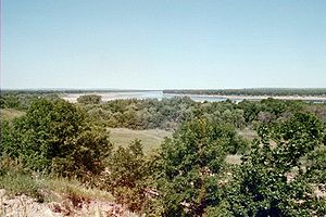
Cretaceous
The Cretaceous , derived from the Latin "creta" , usually abbreviated K for its German translation Kreide , is a geologic period and system from circa to million years ago. In the geologic timescale, the Cretaceous follows the Jurassic period and is followed by the Paleogene period of the...
or early Tertiary
Tertiary
The Tertiary is a deprecated term for a geologic period 65 million to 2.6 million years ago. The Tertiary covered the time span between the superseded Secondary period and the Quaternary...
, lying nearly horizontal. The surface is shown to be a plain of degradation by a gradual ascent here and there to the crest of a ragged escarpment, the escarpment-remnant of a resistant stratum. There are also the occasional lava
Lava
Lava refers both to molten rock expelled by a volcano during an eruption and the resulting rock after solidification and cooling. This molten rock is formed in the interior of some planets, including Earth, and some of their satellites. When first erupted from a volcanic vent, lava is a liquid at...
-capped mesa
Mesa
A mesa or table mountain is an elevated area of land with a flat top and sides that are usually steep cliffs. It takes its name from its characteristic table-top shape....
s and dike
Dike (geology)
A dike or dyke in geology is a type of sheet intrusion referring to any geologic body that cuts discordantly across* planar wall rock structures, such as bedding or foliation...
formed ridges, surmounting the general level by 500 ft (152.4 m) or more and manifestly demonstrating the widespread erosion
Erosion
Erosion is when materials are removed from the surface and changed into something else. It only works by hydraulic actions and transport of solids in the natural environment, and leads to the deposition of these materials elsewhere...
of the surrounding plains. All these reliefs are more plentiful towards the mountains in central Montana. The peneplain is no longer in the cycle of erosion that witnessed its production. It appears to have suffered a regional uplift or increase in elevation, for the upper Missouri River
Missouri River
The Missouri River flows through the central United States, and is a tributary of the Mississippi River. It is the longest river in North America and drains the third largest area, though only the thirteenth largest by discharge. The Missouri's watershed encompasses most of the American Great...
and its branches no longer flow on the surface of the plain, but in well graded, maturely opened valleys, several hundred feet below the general level. A significant exception to the rule of mature valleys occurs, however, in the case of the Missouri, the largest river, which is broken by several falls on hard sandstones about 50 miles (80 km) east of the mountains. This peculiar feature is explained as the result of displacement of the river from a better graded preglacial valley by the Pleistocene
Pleistocene
The Pleistocene is the epoch from 2,588,000 to 11,700 years BP that spans the world's recent period of repeated glaciations. The name pleistocene is derived from the Greek and ....
ice sheet
Ice sheet
An ice sheet is a mass of glacier ice that covers surrounding terrain and is greater than 50,000 km² , thus also known as continental glacier...
. Here, the ice sheet overspread the plains from the moderately elevated Canadian highlands far on the north-east, instead of from the much higher mountains near by on the west. The present altitude of the plains near the mountain base is 4000 ft (1,219.2 m)
The northern plains are interrupted by several small mountain areas. The Black Hills
Black Hills
The Black Hills are a small, isolated mountain range rising from the Great Plains of North America in western South Dakota and extending into Wyoming, USA. Set off from the main body of the Rocky Mountains, the region is something of a geological anomaly—accurately described as an "island of...
, chiefly in western South Dakota
South Dakota
South Dakota is a state located in the Midwestern region of the United States. It is named after the Lakota and Dakota Sioux American Indian tribes. Once a part of Dakota Territory, South Dakota became a state on November 2, 1889. The state has an area of and an estimated population of just over...
, are the largest group. They rise like a large island from the sea, occupying an oval area of about 100 miles (160.9 km) north-south by 50 miles (80.5 km) east-west. At Harney Peak
Harney Peak
Harney Peak is the highest natural point in South Dakota. Harney Peak is located within the Black Elk Wilderness area, in southern Pennington County, within Black Hills National Forest...
, they reach an altitude of 7216 feet (2,199.4 m) and have an effective relief over the plains of 2000 or 3000 ft (914.4 m) This mountain mass is of flat-arched, dome-like structure, now well dissected by radiating consequent streams. The weaker uppermost strata have been eroded down to the level of the plains where their upturned edges are evenly truncated. The next following harder strata have been sufficiently eroded to disclose the core of underlying igneous and metamorphic crystalline rocks in about half of the domed area.
Intermediate Great Plains
44th parallel north
The 44th parallel north is a circle of latitude that is 44 degrees north of the Earth's equatorial plane. It crosses Europe, the Mediterranean Sea, Asia, the Pacific Ocean, North America, and the Atlantic Ocean....
and 42°
42nd parallel north
The 42nd parallel north is a circle of latitude that is 42 degrees north of the Earth's equatorial plane. It crosses Europe, the Mediterranean Sea, Asia, the Pacific Ocean, North America, and the Atlantic Ocean....
, including southern South Dakota
South Dakota
South Dakota is a state located in the Midwestern region of the United States. It is named after the Lakota and Dakota Sioux American Indian tribes. Once a part of Dakota Territory, South Dakota became a state on November 2, 1889. The state has an area of and an estimated population of just over...
and northern Nebraska
Nebraska
Nebraska is a state on the Great Plains of the Midwestern United States. The state's capital is Lincoln and its largest city is Omaha, on the Missouri River....
, the erosion of certain large districts is peculiarly elaborate. Known as the Badlands
Badlands
A badlands is a type of dry terrain where softer sedimentary rocks and clay-rich soils have been extensively eroded by wind and water. It can resemble malpaís, a terrain of volcanic rock. Canyons, ravines, gullies, hoodoos and other such geological forms are common in badlands. They are often...
, it is a minutely dissected form with a relief of a few hundred feet. This is due to several causes:
- the dry climate, which prevents the growth of a grassy turf
- the fine texture of the Tertiary strata in the badland districts
- every little rill, at times of rain, carves its own little valley.
Central Great Plains
42nd parallel north
The 42nd parallel north is a circle of latitude that is 42 degrees north of the Earth's equatorial plane. It crosses Europe, the Mediterranean Sea, Asia, the Pacific Ocean, North America, and the Atlantic Ocean....
and 36°
36th parallel north
The 36th parallel north is a circle of latitude that is 36 degrees north of the Earth's equatorial plane. It crosses Africa, the Mediterranean Sea, Asia, the Pacific Ocean, North America and the Atlantic Ocean....
, occupying eastern Colorado
Colorado
Colorado is a U.S. state that encompasses much of the Rocky Mountains as well as the northeastern portion of the Colorado Plateau and the western edge of the Great Plains...
and western Kansas
Kansas
Kansas is a US state located in the Midwestern United States. It is named after the Kansas River which flows through it, which in turn was named after the Kansa Native American tribe, which inhabited the area. The tribe's name is often said to mean "people of the wind" or "people of the south...
, is, briefly stated, for the most part a dissected fluviatile
Fluvial
Fluvial is used in geography and Earth science to refer to the processes associated with rivers and streams and the deposits and landforms created by them...
plain. That is, this section was once smoothly covered with a gently sloping plain of gravel and sand that had been spread far forward on a broad denuded area as a piedmont
Piedmont (disambiguation)
Piedmont is a region of northwestern Italy, but may also refer to:-Cities:United States*Piedmont, Alabama*Piedmont, California*Piedmont, Missouri*Piedmont, Oklahoma*Piedmont, South Carolina*Piedmont, South Dakota*Piedmont, Virginia...
deposit by the rivers which issued from the mountains. Since then, it has been more or less dissected by the erosion of valleys. The central section of the plains thus presents a marked contrast to the northern section. For while the northern section owes its smoothness to the removal of local gravels and sands from a formerly uneven surface by the action of degrading rivers and their inflowing tributaries, the southern section owes its smoothness to the deposition of imported gravels and sands upon a previously uneven surface by the action of aggrading rivers and their outgoing distributaries. The two sections are also like in that residual eminences still here and there surmount the peneplain of the northern section, while the fluviatile plain of the central section completely buried the pre-existent relief. Exception to this statement must be made in the south-west, close to the mountains in southern Colorado, where some lava-capped mesas (Mesa de Maya, Raton Mesa) stand several thousand feet above the general plain level, and thus testify to the widespread erosion of this region before it was aggraded.
Southern Great Plains
The southern section of the Great Plains, between latitudes 35.5° and 25.5° lies in western TexasTexas
Texas is the second largest U.S. state by both area and population, and the largest state by area in the contiguous United States.The name, based on the Caddo word "Tejas" meaning "friends" or "allies", was applied by the Spanish to the Caddo themselves and to the region of their settlement in...
and eastern New Mexico
New Mexico
New Mexico is a state located in the southwest and western regions of the United States. New Mexico is also usually considered one of the Mountain States. With a population density of 16 per square mile, New Mexico is the sixth-most sparsely inhabited U.S...
. Like the central section, it is for the most part a dissected fluviatile plain. However, the lower lands which surround it on all sides place it in so strong relief that it stands up as a table-land, known from the time of Mexican occupation as the Llano Estacado
Llano Estacado
Llano Estacado , commonly known as the Staked Plains, is a region in the Southwestern United States that encompasses parts of eastern New Mexico and northwestern Texas, including the South Plains and parts of the Texas Panhandle...
. It measures roughly 150 miles (241.4 km) east-west and 400 miles (643.7 km) north-south. It is of very irregular outline, narrowing to the south. Its altitude is 5500 feet (1,676.4 m) at the highest western point, nearest the mountains whence its gravels were supplied. From there, it slopes southeastward at a decreasing rate, first about 12 ft., then about 7 ft per mile (1.3 m/km), to its eastern and southern borders, where it is 2000 feet (609.6 m) in altitude. Like the High Plains farther north, it is extraordinarily smooth.
It is very dry, except for occasional shallow and temporary water sheets after rains. The Llano is separated from the plains on the north by the mature consequent valley of the Canadian River
Canadian River
The Canadian River is the longest tributary of the Arkansas River. It is about long, starting in Colorado and traveling through New Mexico, the Texas Panhandle, and most of Oklahoma....
, and from the mountains on the west by the broad and probably mature valley of the Pecos River
Pecos River
The headwaters of the Pecos River are located north of Pecos, New Mexico, United States, at an elevation of over 12,000 feet on the western slope of the Sangre de Cristo mountain range in Mora County. The river flows for through the eastern portion of that state and neighboring Texas before it...
. On the east, it is strongly undercut by the retrogressive erosion of the headwaters of the Red, Brazos and Colorado rivers of Texas and presents a ragged escarpment approximately 500 to 800 ft (243.8 m) high, overlooking the central denuded area of that state. There, between the Brazos and Colorado rivers, occurs a series of isolated outliers capped by a limestone which underlies both the Llano Uplift
Llano Uplift
The Llano Uplift is a roughly circular geologic dome of Precambrian rock, primarily granite, in Central Texas in the United States. It is located in the eastern region of the Edwards Plateau, west of the Texas Hill Country...
on the west and the Grand Prairies escarpment on the east. The southern and narrow part of the table-land, called the Edwards Plateau
Edwards Plateau
The Edwards Plateau is a region of west-central Texas which is bounded by the Balcones Fault to the south and east, the Llano Uplift and the Llano Estacado to the north, and the Pecos River and Chihuahuan Desert to the west. San Angelo, Austin, San Antonio and Del Rio roughly outline the area...
, is more dissected than the rest, and falls off to the south in a frayed-out fault scarp. As already mentioned, this scarp overlooks the coastal plain of the Rio Grande
Rio Grande
The Rio Grande is a river that flows from southwestern Colorado in the United States to the Gulf of Mexico. Along the way it forms part of the Mexico – United States border. Its length varies as its course changes...
embayment. The central denuded area, east of the Llano, resembles the east-central section of the plains in exposing older rocks. Between these two similar areas, in the space limited by the Canadian and Red rivers, rise the subdued forms of the Wichita Mountains
Wichita Mountains
The Wichita Mountains are located in the southwestern portion of the U.S. state of Oklahoma. The mountains are a northwest-southeast trending series of rocky promontories, many capped by 540 million-year old granite. These were exposed and rounded by weathering during the Permian Period...
in Oklahoma
Oklahoma
Oklahoma is a state located in the South Central region of the United States of America. With an estimated 3,751,351 residents as of the 2010 census and a land area of 68,667 square miles , Oklahoma is the 28th most populous and 20th-largest state...
, the westernmost member of the Ouachita system.