
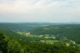
Peneplain
Overview
Terrain
Terrain, or land relief, is the vertical and horizontal dimension of land surface. When relief is described underwater, the term bathymetry is used...
plain
Plain
In geography, a plain is land with relatively low relief, that is flat or gently rolling. Prairies and steppes are types of plains, and the archetype for a plain is often thought of as a grassland, but plains in their natural state may also be covered in shrublands, woodland and forest, or...
representing the final stage of fluvial
Fluvial
Fluvial is used in geography and Earth science to refer to the processes associated with rivers and streams and the deposits and landforms created by them...
erosion
Erosion
Erosion is when materials are removed from the surface and changed into something else. It only works by hydraulic actions and transport of solids in the natural environment, and leads to the deposition of these materials elsewhere...
during times of extended tectonic
Plate tectonics
Plate tectonics is a scientific theory that describes the large scale motions of Earth's lithosphere...
stability. The existence of peneplains, and peneplanation as a geomorphological
Geomorphology
Geomorphology is the scientific study of landforms and the processes that shape them...
process, is not without controversy, due to a lack of contemporary examples and uncertainty in identifying relic examples.
After the streams in an area have reached "base level
Base level
The base level of a river or stream is the lowest point to which it can flow, often referred to as the 'mouth' of the river. For large rivers, sea level is usually the base level, but a large river or lake is likewise the base level for tributary streams...
", lateral erosion is dominant as the higher areas between the streams are eroded.
Unanswered Questions