

36th parallel north
Encyclopedia
The 36th parallel north is a circle of latitude
that is 36 degrees
north
of the Earth's
equatorial plane
. It crosses Africa
, the Mediterranean Sea
, Asia
, the Pacific Ocean
, North America
and the Atlantic Ocean
.
From 7 April 1991 to 31 December 1996, the parallel defined the limit of the northern no-fly zone
in Iraq
.
At this latitude the sun
is visible for 14 hours, 36 minutes during the summer solstice
and 9 hours, 43 minutes during the winter solstice
.
Starting at the Prime Meridian
and heading eastwards, the parallel 36° north passes through:
 Cities and landmarks close to the parallel include Kettleman City, California
, Henderson, Nevada
, Hoover Dam
, South Rim of the Grand Canyon
, Los Alamos National Laboratory
, Tulsa, Oklahoma
, Nashville, Tennessee
, Knoxville, Tennessee
, Winston-Salem, North Carolina
, High Point, North Carolina
, Greensboro, North Carolina
, Durham, North Carolina
, Chapel Hill, North Carolina
, and others.
The sixth standard parallel south of Mount Diablo at 35°48′ north, 13.8344 miles south of the 36th parallel, forms a continuous boundary between the California counties of
Monterey
,
Kings
,
Tulare
, and
Inyo
on the north and the counties of
San Luis Obispo
,
Kern
, and
San Bernardino
on the south. It is sometimes taken as the boundary between Northern California
and Southern California
, although definitions using the Tehachapi Mountains
are also common.
The parallel 36° north approximately forms the southernmost boundary of the Missouri Bootheel with the State of Arkansas
.
The 36th parallel passes through Duke University in several places. Its Campus Drive that connects the campuses crosses the parallel several times. The Duke Gardens
has a "36th Parallel Club" although the garden itself is just north of the parallel.
Circle of latitude
A circle of latitude, on the Earth, is an imaginary east-west circle connecting all locations that share a given latitude...
that is 36 degrees
Degree (angle)
A degree , usually denoted by ° , is a measurement of plane angle, representing 1⁄360 of a full rotation; one degree is equivalent to π/180 radians...
north
True north
True north is the direction along the earth's surface towards the geographic North Pole.True geodetic north usually differs from magnetic north , and from grid north...
of the Earth's
Earth
Earth is the third planet from the Sun, and the densest and fifth-largest of the eight planets in the Solar System. It is also the largest of the Solar System's four terrestrial planets...
equatorial plane
Equator
An equator is the intersection of a sphere's surface with the plane perpendicular to the sphere's axis of rotation and containing the sphere's center of mass....
. It crosses Africa
Africa
Africa is the world's second largest and second most populous continent, after Asia. At about 30.2 million km² including adjacent islands, it covers 6% of the Earth's total surface area and 20.4% of the total land area...
, the Mediterranean Sea
Mediterranean Sea
The Mediterranean Sea is a sea connected to the Atlantic Ocean surrounded by the Mediterranean region and almost completely enclosed by land: on the north by Anatolia and Europe, on the south by North Africa, and on the east by the Levant...
, Asia
Asia
Asia is the world's largest and most populous continent, located primarily in the eastern and northern hemispheres. It covers 8.7% of the Earth's total surface area and with approximately 3.879 billion people, it hosts 60% of the world's current human population...
, the Pacific Ocean
Pacific Ocean
The Pacific Ocean is the largest of the Earth's oceanic divisions. It extends from the Arctic in the north to the Southern Ocean in the south, bounded by Asia and Australia in the west, and the Americas in the east.At 165.2 million square kilometres in area, this largest division of the World...
, North America
North America
North America is a continent wholly within the Northern Hemisphere and almost wholly within the Western Hemisphere. It is also considered a northern subcontinent of the Americas...
and the Atlantic Ocean
Atlantic Ocean
The Atlantic Ocean is the second-largest of the world's oceanic divisions. With a total area of about , it covers approximately 20% of the Earth's surface and about 26% of its water surface area...
.
From 7 April 1991 to 31 December 1996, the parallel defined the limit of the northern no-fly zone
Iraqi no-fly zones
The Iraqi no-fly zones were a set of two separate no-fly zones , and were proclaimed by the United States, United Kingdom and France after the Gulf War of 1991 to protect the Kurdish people in northern Iraq and Shiite Muslims in the south. Iraqi aircraft were forbidden from flying inside the zones...
in Iraq
Iraq
Iraq ; officially the Republic of Iraq is a country in Western Asia spanning most of the northwestern end of the Zagros mountain range, the eastern part of the Syrian Desert and the northern part of the Arabian Desert....
.
At this latitude the sun
Sun
The Sun is the star at the center of the Solar System. It is almost perfectly spherical and consists of hot plasma interwoven with magnetic fields...
is visible for 14 hours, 36 minutes during the summer solstice
Summer solstice
The summer solstice occurs exactly when the axial tilt of a planet's semi-axis in a given hemisphere is most inclined towards the star that it orbits. Earth's maximum axial tilt to our star, the Sun, during a solstice is 23° 26'. Though the summer solstice is an instant in time, the term is also...
and 9 hours, 43 minutes during the winter solstice
Winter solstice
Winter solstice may refer to:* Winter solstice, astronomical event* Winter Solstice , former band* Winter Solstice: North , seasonal songs* Winter Solstice , 2005 American film...
.
Starting at the Prime Meridian
Prime Meridian
The Prime Meridian is the meridian at which the longitude is defined to be 0°.The Prime Meridian and its opposite the 180th meridian , which the International Date Line generally follows, form a great circle that divides the Earth into the Eastern and Western Hemispheres.An international...
and heading eastwards, the parallel 36° north passes through:
| Co-ordinates | Country, territory or sea | Notes |
|---|---|---|
| 36°0′N 0°0′E | Mediterranean Sea Mediterranean Sea The Mediterranean Sea is a sea connected to the Atlantic Ocean surrounded by the Mediterranean region and almost completely enclosed by land: on the north by Anatolia and Europe, on the south by North Africa, and on the east by the Levant... |
|
| 36°0′N 0°7′E | ||
| 36°0′N 8°18′E | ||
| 36°0′N 10°31′E | Mediterranean Sea Mediterranean Sea The Mediterranean Sea is a sea connected to the Atlantic Ocean surrounded by the Mediterranean region and almost completely enclosed by land: on the north by Anatolia and Europe, on the south by North Africa, and on the east by the Levant... |
Passing just north of the island of Linosa Linosa Linosa is one of the Pelagie Islands in the Sicily Channel of the Mediterranean Sea. It is a frazione of the comune of Lampedusa e Linosa, part of the province of Agrigento, Sicily, Italy. It has a population of 450 inhabitants.-Geography:... , > Passing between the islands of Comino Comino Comino is an island of the Maltese archipelago between the islands of Malta and Gozo in the Mediterranean Sea, measuring in area. Named after the cumin seed that once flourished in the Maltese islands, Comino is noted for its tranquility and isolation. It has a permanent population of only four... and Malta Malta Island Malta Island is the largest of the three major islands that constitute the Maltese archipelago and Republic of Malta. Malta is in the middle of the Mediterranean Sea directly south of Italy and north of Libya. The area is 246 km² . The capital is Valletta, largest city is Qormi and the largest... , |
| 36°0′N 23°10′E | Aegean Sea Aegean Sea The Aegean Sea[p] is an elongated embayment of the Mediterranean Sea located between the southern Balkan and Anatolian peninsulas, i.e., between the mainlands of Greece and Turkey. In the north, it is connected to the Marmara Sea and Black Sea by the Dardanelles and Bosporus... |
Passing between the islands of Kythira Kythira Cythera is an island in Greece, once part of the Ionian Islands. It lies opposite the south-eastern tip of the Peloponnese peninsula. It is administratively part of the Islands regional unit, which is part of the Attica region , Greece.For many centuries, while naval travel was the only means... and Antikythera Antikythera Antikythera or Anticythera is a Greek island lying on the edge of the Aegean Sea, between Crete and Peloponnese. Since the 2011 local government reform it is part of the municipality of Kythira island.... , > Passing just north of Saria Island Saria Island Saria Island is an island in Greece. It is a rocky, volcanic island along the northern edge of Karpathos, separated from it by a strait 100 m wide. Administratively, it is part of the community of Olympos. The 2001 census reported a resident population of 22 persons. It has little plant or animal... , |
| 36°0′N 27°45′E | Island of Rhodes Rhodes Rhodes is an island in Greece, located in the eastern Aegean Sea. It is the largest of the Dodecanese islands in terms of both land area and population, with a population of 117,007, and also the island group's historical capital. Administratively the island forms a separate municipality within... |
|
| 36°0′N 27°55′E | Mediterranean Sea Mediterranean Sea The Mediterranean Sea is a sea connected to the Atlantic Ocean surrounded by the Mediterranean region and almost completely enclosed by land: on the north by Anatolia and Europe, on the south by North Africa, and on the east by the Levant... |
|
| 36°0′N 35°59′E | ||
| 36°0′N 36°22′E | ||
| 36°0′N 41°17′E | ||
| 36°0′N 45°21′E | ||
| 36°0′N 61°10′E | ||
| 36°0′N 63°49′E | ||
| 36°0′N 71°15′E | Khyber Pakhtunkhwa > Gilgit-Baltistan - claimed by |
|
| 36°0′N 76°6′E | Shaksgam Valley | Area administered by , claimed by |
| 36°0′N 76°48′E | Xinjiang Xinjiang Xinjiang is an autonomous region of the People's Republic of China. It is the largest Chinese administrative division and spans over 1.6 million km2... > Tibet Tibet Autonomous Region The Tibet Autonomous Region , Tibet or Xizang for short, also called the Xizang Autonomous Region is a province-level autonomous region of the People's Republic of China , created in 1965.... > Qinghai Qinghai Qinghai ; Oirat Mongolian: ; ; Salar:) is a province of the People's Republic of China, named after Qinghai Lake... > Gansu Gansu ' is a province located in the northwest of the People's Republic of China.It lies between the Tibetan and Huangtu plateaus, and borders Mongolia, Inner Mongolia, and Ningxia to the north, Xinjiang and Qinghai to the west, Sichuan to the south, and Shaanxi to the east... — passing just south of Lanzhou Lanzhou Lanzhou is the capital and largest city of Gansu Province in Northwest China. A prefecture-level city, it is a key regional transportation hub, allowing areas further west to maintain railroad connections to the eastern half of the country.... > Ningxia Ningxia Ningxia, formerly transliterated as Ningsia, is an autonomous region of the People's Republic of China. Located in Northwest China, on the Loess Plateau, the Yellow River flows through this vast area of land. The Great Wall of China runs along its northeastern boundary... > Gansu > Shaanxi Shaanxi ' is a province in the central part of Mainland China, and it includes portions of the Loess Plateau on the middle reaches of the Yellow River in addition to the Qinling Mountains across the southern part of this province... > Shanxi Shanxi ' is a province in Northern China. Its one-character abbreviation is "晋" , after the state of Jin that existed here during the Spring and Autumn Period.... > Henan Henan Henan , is a province of the People's Republic of China, located in the central part of the country. Its one-character abbreviation is "豫" , named after Yuzhou , a Han Dynasty state that included parts of Henan... > Shandong Shandong ' is a Province located on the eastern coast of the People's Republic of China. Shandong has played a major role in Chinese history from the beginning of Chinese civilization along the lower reaches of the Yellow River and served as a pivotal cultural and religious site for Taoism, Chinese... > Henan (for about 15 km) > Shandong — passing just south of Qingdao Qingdao ' also known in the West by its postal map spelling Tsingtao, is a major city with a population of over 8.715 million in eastern Shandong province, Eastern China. Its built up area, made of 7 urban districts plus Jimo city, is home to about 4,346,000 inhabitants in 2010.It borders Yantai to the... |
|
| 36°0′N 120°18′E | Yellow Sea Yellow Sea The Yellow Sea is the name given to the northern part of the East China Sea, which is a marginal sea of the Pacific Ocean. It is located between mainland China and the Korean Peninsula. Its name comes from the sand particles from Gobi Desert sand storms that turn the surface of the water golden... |
|
| 36°0′N 126°42′E | ||
| 36°0′N 129°35′E | Sea of Japan Sea of Japan The Sea of Japan is a marginal sea of the western Pacific Ocean, between the Asian mainland, the Japanese archipelago and Sakhalin. It is bordered by Japan, North Korea, Russia and South Korea. Like the Mediterranean Sea, it has almost no tides due to its nearly complete enclosure from the Pacific... |
|
| 36°0′N 133°1′E | Island of Chiburi-shima Chibu, Shimane is a village located on in the Douzen group of islands in the Oki District, Shimane, Japan. Chibu is the only village remaining in Shimane Prefecture as of October 1, 2005.... : — Shimane Prefecture Shimane Prefecture is a prefecture of Japan located in the Chūgoku region on Honshū island. The capital is Matsue. It is the second least populous prefecture in Japan, after its eastern neighbor Tottori. The prefecture has an area elongated from east to west facing the Chūgoku Mountain Range on the south side and to... |
|
| 36°0′N 133°4′E | Sea of Japan Sea of Japan The Sea of Japan is a marginal sea of the western Pacific Ocean, between the Asian mainland, the Japanese archipelago and Sakhalin. It is bordered by Japan, North Korea, Russia and South Korea. Like the Mediterranean Sea, it has almost no tides due to its nearly complete enclosure from the Pacific... |
|
| 36°0′N 135°58′E | Island of Honshū Honshu is the largest island of Japan. The nation's main island, it is south of Hokkaido across the Tsugaru Strait, north of Shikoku across the Inland Sea, and northeast of Kyushu across the Kanmon Strait... : >— Fukui Prefecture Fukui Prefecture is a prefecture of Japan located in the Chūbu region on Honshū island. The capital is the city of Fukui.- Prehistory :The Kitadani Dinosaur Quarry, on the Sugiyama River within the city limits of Katsuyama, has yielded the Fukuiraptor kitadaniensis and Fukuisaurus tetoriensis as well as an unnamed... >— Gifu Prefecture Gifu Prefecture is a prefecture located in the Chūbu region of central Japan. Its capital is the city of Gifu.Located in the center of Japan, it has long played an important part as the crossroads of Japan, connecting the east to the west through such routes as the Nakasendō... >— Nagano Prefecture Nagano Prefecture is a prefecture of Japan located in the Chūbu region of the island of Honshū. The capital is the city of Nagano.- History :Nagano was formerly known as the province of Shinano... >— Gunma Prefecture Gunma Prefecture is a prefecture of Japan located in the northwest corner of the Kantō region on Honshu island. Its capital is Maebashi.- History :The remains of a Paleolithic man were found at Iwajuku, Gunma Prefecture, in the early 20th century and there is a public museum there.Japan was without horses until... − for about 4 km >— Saitama Prefecture Saitama Prefecture is a prefecture of Japan located in the Kantō region of the island of Honshu. The capital is the city of Saitama.This prefecture is part of the Greater Tokyo Area, and most of Saitama's cities can be described as suburbs of Tokyo, to which a large amount of residents commute each day.- History... >— Chiba Prefecture Chiba Prefecture is a prefecture of Japan located in the Kantō region and the Greater Tokyo Area. Its capital is Chiba City.- History :Chiba Prefecture was established on June 15, 1873 with the merger of Kisarazu Prefecture and Inba Prefecture... − for about 6 km >— Ibaraki Prefecture Ibaraki Prefecture is a prefecture of Japan, located in the Kantō region on the main island of Honshu. The capital is Mito.-History:Ibaraki Prefecture was previously known as Hitachi Province... |
|
| 36°0′N 140°40′E | Pacific Ocean Pacific Ocean The Pacific Ocean is the largest of the Earth's oceanic divisions. It extends from the Arctic in the north to the Southern Ocean in the south, bounded by Asia and Australia in the west, and the Americas in the east.At 165.2 million square kilometres in area, this largest division of the World... |
|
| 36°0′N 121°30′W | California California California is a state located on the West Coast of the United States. It is by far the most populous U.S. state, and the third-largest by land area... > Nevada Nevada Nevada is a state in the western, mountain west, and southwestern regions of the United States. With an area of and a population of about 2.7 million, it is the 7th-largest and 35th-most populous state. Over two-thirds of Nevada's people live in the Las Vegas metropolitan area, which contains its... > Arizona Arizona Arizona ; is a state located in the southwestern region of the United States. It is also part of the western United States and the mountain west. The capital and largest city is Phoenix... > New Mexico New Mexico New Mexico is a state located in the southwest and western regions of the United States. New Mexico is also usually considered one of the Mountain States. With a population density of 16 per square mile, New Mexico is the sixth-most sparsely inhabited U.S... > Texas Texas Texas is the second largest U.S. state by both area and population, and the largest state by area in the contiguous United States.The name, based on the Caddo word "Tejas" meaning "friends" or "allies", was applied by the Spanish to the Caddo themselves and to the region of their settlement in... > Oklahoma Oklahoma Oklahoma is a state located in the South Central region of the United States of America. With an estimated 3,751,351 residents as of the 2010 census and a land area of 68,667 square miles , Oklahoma is the 28th most populous and 20th-largest state... > Arkansas Arkansas Arkansas is a state located in the southern region of the United States. Its name is an Algonquian name of the Quapaw Indians. Arkansas shares borders with six states , and its eastern border is largely defined by the Mississippi River... > Missouri Missouri Missouri is a US state located in the Midwestern United States, bordered by Iowa, Illinois, Kentucky, Tennessee, Arkansas, Oklahoma, Kansas and Nebraska. With a 2010 population of 5,988,927, Missouri is the 18th most populous state in the nation and the fifth most populous in the Midwest. It... / Arkansas border (approximate) > Tennessee Tennessee Tennessee is a U.S. state located in the Southeastern United States. It has a population of 6,346,105, making it the nation's 17th-largest state by population, and covers , making it the 36th-largest by total land area... > North Carolina North Carolina North Carolina is a state located in the southeastern United States. The state borders South Carolina and Georgia to the south, Tennessee to the west and Virginia to the north. North Carolina contains 100 counties. Its capital is Raleigh, and its largest city is Charlotte... (for about 14 km) > Tennessee (for about 12 km) > North Carolina |
|
| 36°0′N 75°39′W | Atlantic Ocean Atlantic Ocean The Atlantic Ocean is the second-largest of the world's oceanic divisions. With a total area of about , it covers approximately 20% of the Earth's surface and about 26% of its water surface area... |
|
| 36°0′N 5°50′W | Strait of Gibraltar Strait of Gibraltar The Strait of Gibraltar is a narrow strait that connects the Atlantic Ocean to the Mediterranean Sea and separates Spain in Europe from Morocco in Africa. The name comes from Gibraltar, which in turn originates from the Arabic Jebel Tariq , albeit the Arab name for the Strait is Bab el-Zakat or... |
Passing a few metres south of Punta de Tarifa Punta de Tarifa Punta de Tarifa is the southernmost point of the Iberian Peninsula and continental Europe. It is located in the province of Cádiz and the autonomous community of Andalusia on the Atlantic end of the Straits of Gibraltar. The coast of Morocco can be seen from this point.... , - the most southerly point of the European mainland Extreme points of Europe This is a list of the extreme points of Europe: the geographical points that are higher, farther north, south, east or west than any other location in Europe. Some of these positions are open to debate, as the definition of Europe is diverse.... |
| 36°0′N 5°25′W | Mediterranean Sea Mediterranean Sea The Mediterranean Sea is a sea connected to the Atlantic Ocean surrounded by the Mediterranean region and almost completely enclosed by land: on the north by Anatolia and Europe, on the south by North Africa, and on the east by the Levant... |
United States
Kettleman City, California
Kettleman City is a census-designated place in Kings County, California, United States. Kettleman City is located southwest of Hanford, at an elevation of 253 feet . It is part of the Hanford–Corcoran Metropolitan Statistical Area. The population was 1,439 at the 2010 census, down from...
, Henderson, Nevada
Henderson, Nevada
-Demographics:According to the 2000 census, there were 175,381 people, 66,331 households, and 47,095 families residing in the city. The population density was 2,200.8 people per square mile . There were 71,149 housing units at an average density of 892.8 per square mile...
, Hoover Dam
Hoover Dam
Hoover Dam, once known as Boulder Dam, is a concrete arch-gravity dam in the Black Canyon of the Colorado River, on the border between the US states of Arizona and Nevada. It was constructed between 1931 and 1936 during the Great Depression and was dedicated on September 30, 1935, by President...
, South Rim of the Grand Canyon
Grand Canyon
The Grand Canyon is a steep-sided canyon carved by the Colorado River in the United States in the state of Arizona. It is largely contained within the Grand Canyon National Park, the 15th national park in the United States...
, Los Alamos National Laboratory
Los Alamos National Laboratory
Los Alamos National Laboratory is a United States Department of Energy national laboratory, managed and operated by Los Alamos National Security , located in Los Alamos, New Mexico...
, Tulsa, Oklahoma
Tulsa, Oklahoma
Tulsa is the second-largest city in the state of Oklahoma and 46th-largest city in the United States. With a population of 391,906 as of the 2010 census, it is the principal municipality of the Tulsa Metropolitan Area, a region with 937,478 residents in the MSA and 988,454 in the CSA. Tulsa's...
, Nashville, Tennessee
Nashville, Tennessee
Nashville is the capital of the U.S. state of Tennessee and the county seat of Davidson County. It is located on the Cumberland River in Davidson County, in the north-central part of the state. The city is a center for the health care, publishing, banking and transportation industries, and is home...
, Knoxville, Tennessee
Knoxville, Tennessee
Founded in 1786, Knoxville is the third-largest city in the U.S. state of Tennessee, U.S.A., behind Memphis and Nashville, and is the county seat of Knox County. It is the largest city in East Tennessee, and the second-largest city in the Appalachia region...
, Winston-Salem, North Carolina
Winston-Salem, North Carolina
Winston-Salem is a city in the U.S. state of North Carolina, with a 2010 population of 229,617. Winston-Salem is the county seat and largest city of Forsyth County and the fourth-largest city in the state. Winston-Salem is the second largest municipality in the Piedmont Triad region and is home to...
, High Point, North Carolina
High Point, North Carolina
High Point is a city located in the Piedmont Triad region of North Carolina. As of 2010 the city had a total population of 104,371, according to the US Census Bureau. High Point is currently the eighth-largest municipality in North Carolina....
, Greensboro, North Carolina
Greensboro, North Carolina
Greensboro is a city in the U.S. state of North Carolina. It is the third-largest city by population in North Carolina and the largest city in Guilford County and the surrounding Piedmont Triad metropolitan region. According to the 2010 U.S...
, Durham, North Carolina
Durham, North Carolina
Durham is a city in the U.S. state of North Carolina. It is the county seat of Durham County and also extends into Wake County. It is the fifth-largest city in the state, and the 85th-largest in the United States by population, with 228,330 residents as of the 2010 United States census...
, Chapel Hill, North Carolina
Chapel Hill, North Carolina
Chapel Hill is a town in Orange County, North Carolina, United States and the home of the University of North Carolina at Chapel Hill and UNC Health Care...
, and others.
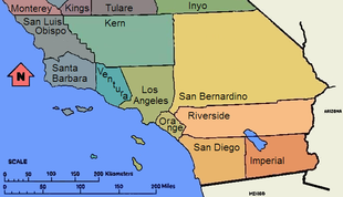
The sixth standard parallel south of Mount Diablo at 35°48′ north, 13.8344 miles south of the 36th parallel, forms a continuous boundary between the California counties of
Monterey
Monterey County, California
Monterey County is a county located on the Pacific coast of the U.S. state of California, its northwestern section forming the southern half of Monterey Bay. The northern half of the bay is in Santa Cruz County. As of 2010, the population was 415,057. The county seat and largest city is Salinas...
,
Kings
Kings County, California
Kings County is a county located in the Central Valley of the U.S. state of California. It is located in a rich agricultural region. Kings County is also home to NAS Lemoore, which is the U.S. Navy's newest and largest master jet air station. The county seat is Hanford...
,
Tulare
Tulare County, California
Tulare County is a county located in the Central Valley of the U.S. state of California, south of Fresno. Sequoia National Park is located in the county, as are part of Kings Canyon National Park, in its northeast corner , and part of Mount Whitney, on its eastern border...
, and
Inyo
Inyo County, California
-National protected areas:* Death Valley National Park * Inyo National Forest * Manzanar National Historic Site-Major highways:* U.S. Route 6* U.S. Route 395* State Route 127* State Route 136* State Route 168* State Route 178...
on the north and the counties of
San Luis Obispo
San Luis Obispo County, California
San Luis Obispo County is a county located along the Pacific Ocean in the Central Coast of the U.S. state of California, between Los Angeles and the San Francisco Bay Area. As of the 2010 census its population was 269,637, up from 246,681 at the 2000 census...
,
Kern
Kern County, California
Spreading across the southern end of the California Central Valley, Kern County is the fifth-largest county by population in California. Its economy is heavily linked to agriculture and to petroleum extraction, and there is a strong aviation and space presence. Politically, it has generally...
, and
San Bernardino
San Bernardino County, California
San Bernardino County is a county in the U.S. state of California. As of the 2010 census, the population was 2,035,210, up from 1,709,434 as of the 2000 census...
on the south. It is sometimes taken as the boundary between Northern California
Northern California
Northern California is the northern portion of the U.S. state of California. The San Francisco Bay Area , and Sacramento as well as its metropolitan area are the main population centers...
and Southern California
Southern California
Southern California is a megaregion, or megapolitan area, in the southern area of the U.S. state of California. Large urban areas include Greater Los Angeles and Greater San Diego. The urban area stretches along the coast from Ventura through the Southland and Inland Empire to San Diego...
, although definitions using the Tehachapi Mountains
Tehachapi Mountains
The Tehachapi Mountains , regionally also called The Tehachapis, are a mountain range in the Transverse Ranges system of California in the Western United States...
are also common.
The parallel 36° north approximately forms the southernmost boundary of the Missouri Bootheel with the State of Arkansas
Arkansas
Arkansas is a state located in the southern region of the United States. Its name is an Algonquian name of the Quapaw Indians. Arkansas shares borders with six states , and its eastern border is largely defined by the Mississippi River...
.
The 36th parallel passes through Duke University in several places. Its Campus Drive that connects the campuses crosses the parallel several times. The Duke Gardens
Sarah P. Duke Gardens
The Sarah P. Duke Gardens consist of approximately 55 acres of landscaped and wooded areas at Duke University. There are five miles of allées, walks, and pathways throughout the gardens...
has a "36th Parallel Club" although the garden itself is just north of the parallel.
See also
- 35th parallel north35th parallel northThe 35th parallel north is a circle of latitude that is 35 degrees north of the Earth's equatorial plane. It crosses Africa, the Mediterranean Sea, Asia, the Pacific Ocean, North America and the Atlantic Ocean....
- Parallel 36°30′ north
- 37th parallel north37th parallel northThe 37th parallel north is a circle of latitude that is 37 degrees north of the Earth's equatorial plane. It crosses Europe, the Mediterranean Sea, Africa, Asia, the Pacific Ocean, North America, and the Atlantic Ocean....