

Drumlin
Encyclopedia
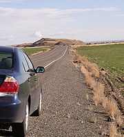
A drumlin, from the Irish word droimnín ("little ridge"), first recorded in 1833, is an elongated whale-shaped hill
formed by glacial
ice acting on underlying unconsolidated till
or ground moraine
.
 Drumlins and drumlin clusters are glacial landforms which have been extensively studied. Geologists have proposed several theories
about their origin. They are formed a short distance within the receding glacier ice and record the final direction of ice movement. Drumlins occur in symmetric, spindle, parabolic, and transverse asymmetrical forms. Drumlins are commonly found with other major glacially-formed features and are related on a regional scale to these landforms. The large-scale patterns of these features exhibit spatial organization of the drumlin-forming flows with related tunnel valley
s, esker
s, scours, and exposed bedrock erosion (scallop
ing and sichelwannen).
Although one formation theory originally proposed since the 1980s by John Shaw and collaborators postulates drumlin creation by a catastrophic flooding release of highly pressurized water flowing underneath the glacial ice, the recent retreat of a marginal outlet glacier of Hofsjökull
in Iceland provided the opportunity for direct study of a drumlin field with formation of >50 drumlins ranging from 90 to 320 m (295.3 to 1,049.9 ft) in length, 30 to 105 m (98.4 to 344.5 ft) in width, and 5 to 10 m (16.4 to 32.8 ft) in height. This, when combined with drumlin formation identified through imaging beneath the West Antarctica ice, resulted in a significant step in geomorphologic
understanding. The Hofsjökull marginal drumlins formed through a progression of subglacial depositional and erosional processes with each horizontal till bed within the drumlin created by an individual surge of the glacier. Erosion under the glacier in the immediate vicinity of the drumlin can be on the order of a meter's depth of sediment per year, with the eroded sediment forming a drumlin as it is repositioned and deposited.
s of similarly shaped, sized and oriented hills. Drumlins usually have layers indicating that the material was repeatedly added to a core, which may be of rock
or glacial till. The composition of drumlins varies depending on the area in which they are found, and can consist of similar material to the till of the surrounding moraine or be composed almost entirely of bedrock, sand and gravel or various mixtures thereof.
Many Pleistocene drumlin fields are observed to occur in a fan-like distribution. The Múlajökull drumlins are also arrayed in a splayed fan distribution around an arc of 180°.
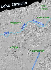
(often referred to as "'topsoil'" which accumulated after formation) and a thin Bw horizon (commonly referred to as "'subsoil'"). The C horizon, which shows little evidence of being affected by soil forming processes (weathering), is close to the surface, and may be at the surface on an eroded drumlin. Below the C horizon the drumlin consists of multiple beds of till deposited by lodgment and bed deformation. On drumlins with longer exposure (e.g. in the Lake Ontario drumlin field in New York State) soil development is more advanced, for example with the formation of clay-enriched Bt horizons.
ic glacier Múlajökull, which is an outlet glacier of Hofsjökull
, recently exposed a 50 drumlin cluster, which serves as the basis for improved understanding of drumlin formation.
The literature also documents extensive drumlin fields in Scotland, England, Switzerland, Poland, Estonia
, Sweden, around Lake Constance
north of the Alps
, County Monaghan
, County Mayo
, County Cavan
, County Fermanagh
and County Down
in Ireland, Germany, Hindsholm
in Denmark, Finland and Greenland
.
Clew Bay
in Ireland is a good example of a 'drowned drumlin' landscape where the drumlins appear as islands in the sea, forming a 'basket of eggs' topography. Drumlins are typically aligned parallel to one another, usually clustered together in numbers reaching the hundreds or even thousands. These clusters can sometimes lead to the natural emergence and growth of complex water systems.
, eastern Massachusetts
, the Monadnock Region
of New Hampshire
, Minnesota
, and Wisconsin
. Drumlins, which are usually found in swarms or large groups, occur in every Canadian province and territory. Swarms of thousands of drumlins are found in Southern Ontario
, Douro-Dummer, Ontario
, the Thelon Plan of the Northwest Territories
, Alberta
, Nunavut
and Nova Scotia
. The majority of those observed in North America were formed during the Wisconsin glaciation
.
The islands of Boston Harbor Islands National Recreation Area
are drumlins that became islands when sea levels rose as the glaciers melted.
, for example near Punta Arenas Carlos Ibáñez del Campo Airport and on Navarino and Gable Island
in the Beagle Channel
.
Hill
A hill is a landform that extends above the surrounding terrain. Hills often have a distinct summit, although in areas with scarp/dip topography a hill may refer to a particular section of flat terrain without a massive summit A hill is a landform that extends above the surrounding terrain. Hills...
formed by glacial
Glacier
A glacier is a large persistent body of ice that forms where the accumulation of snow exceeds its ablation over many years, often centuries. At least 0.1 km² in area and 50 m thick, but often much larger, a glacier slowly deforms and flows due to stresses induced by its weight...
ice acting on underlying unconsolidated till
Till
thumb|right|Closeup of glacial till. Note that the larger grains in the till are completely surrounded by the matrix of finer material , and this characteristic, known as matrix support, is diagnostic of till....
or ground moraine
Moraine
A moraine is any glacially formed accumulation of unconsolidated glacial debris which can occur in currently glaciated and formerly glaciated regions, such as those areas acted upon by a past glacial maximum. This debris may have been plucked off a valley floor as a glacier advanced or it may have...
.
Drumlin formation
Theory
The English word theory was derived from a technical term in Ancient Greek philosophy. The word theoria, , meant "a looking at, viewing, beholding", and referring to contemplation or speculation, as opposed to action...
about their origin. They are formed a short distance within the receding glacier ice and record the final direction of ice movement. Drumlins occur in symmetric, spindle, parabolic, and transverse asymmetrical forms. Drumlins are commonly found with other major glacially-formed features and are related on a regional scale to these landforms. The large-scale patterns of these features exhibit spatial organization of the drumlin-forming flows with related tunnel valley
Tunnel valley
A tunnel valley is a large, long, U-shaped valley originally cut under the glacial ice near the margin of continental ice sheets such as that now covering Antarctica and formerly covering portions of all continents during past glacial ages....
s, esker
Esker
An esker is a long winding ridge of stratified sand and gravel, examples of which occur in glaciated and formerly glaciated regions of Europe and North America...
s, scours, and exposed bedrock erosion (scallop
Scalloped topography
Scalloped topography is common in the mid-latitudes of Mars, between 45° and 60° north and south. It is particularly prominent in the region of Utopia Planitia, , in the northern hemisphere, and in the region of Peneus and Amphitrites Patera in the southern hemisphere...
ing and sichelwannen).
Although one formation theory originally proposed since the 1980s by John Shaw and collaborators postulates drumlin creation by a catastrophic flooding release of highly pressurized water flowing underneath the glacial ice, the recent retreat of a marginal outlet glacier of Hofsjökull
Hofsjökull
Hofsjökull is the third largest glacier in Iceland after Vatnajökull and Langjökull and the largest active volcano in the country. It situates at the west of the Highlands of Iceland and north of the mountain range Kerlingarfjöll, between the two largest glaciers of Iceland. It covers an area of...
in Iceland provided the opportunity for direct study of a drumlin field with formation of >50 drumlins ranging from 90 to 320 m (295.3 to 1,049.9 ft) in length, 30 to 105 m (98.4 to 344.5 ft) in width, and 5 to 10 m (16.4 to 32.8 ft) in height. This, when combined with drumlin formation identified through imaging beneath the West Antarctica ice, resulted in a significant step in geomorphologic
Geomorphology
Geomorphology is the scientific study of landforms and the processes that shape them...
understanding. The Hofsjökull marginal drumlins formed through a progression of subglacial depositional and erosional processes with each horizontal till bed within the drumlin created by an individual surge of the glacier. Erosion under the glacier in the immediate vicinity of the drumlin can be on the order of a meter's depth of sediment per year, with the eroded sediment forming a drumlin as it is repositioned and deposited.
Geomorphology
A drumlins long axis is parallel with the movement of the ice it is roughly symmetrical around the long axis. Drumlins are typically 1 to 2 km (0.621372736649807 to 1.2 mi) long, less than 50 m (164 ft) high and between 300 to 600 m (984.3 to 1,968.5 ft) wide. Drumlins generally have a consistent ratio of 2:3.5 width to length dimensions. Drumlins are often in drumlin fieldDrumlin field
A drumlin field is a cluster of dozens to hundreds of similarly shaped, sized and oriented drumlins, also called a drumlin swarm. Drumlins are one type of landform that indicate continental ice sheet glaciation...
s of similarly shaped, sized and oriented hills. Drumlins usually have layers indicating that the material was repeatedly added to a core, which may be of rock
Rock (geology)
In geology, rock or stone is a naturally occurring solid aggregate of minerals and/or mineraloids.The Earth's outer solid layer, the lithosphere, is made of rock. In general rocks are of three types, namely, igneous, sedimentary, and metamorphic...
or glacial till. The composition of drumlins varies depending on the area in which they are found, and can consist of similar material to the till of the surrounding moraine or be composed almost entirely of bedrock, sand and gravel or various mixtures thereof.
Many Pleistocene drumlin fields are observed to occur in a fan-like distribution. The Múlajökull drumlins are also arrayed in a splayed fan distribution around an arc of 180°.
Soil development on drumlins
Drumlin soil is variable but on recently-formed drumlins often consists of a thin A soil horizonSoil horizon
A soil horizon is a specific layer in the land area that is parallel to the soil surface and possesses physical characteristics which differ from the layers above and beneath. Horizon formation is a function of a range of geological, chemical, and biological processes and occurs over long time...
(often referred to as "'topsoil'" which accumulated after formation) and a thin Bw horizon (commonly referred to as "'subsoil'"). The C horizon, which shows little evidence of being affected by soil forming processes (weathering), is close to the surface, and may be at the surface on an eroded drumlin. Below the C horizon the drumlin consists of multiple beds of till deposited by lodgment and bed deformation. On drumlins with longer exposure (e.g. in the Lake Ontario drumlin field in New York State) soil development is more advanced, for example with the formation of clay-enriched Bt horizons.
Examples of drumlins
Europe
The retreat of IcelandIceland
Iceland , described as the Republic of Iceland, is a Nordic and European island country in the North Atlantic Ocean, on the Mid-Atlantic Ridge. Iceland also refers to the main island of the country, which contains almost all the population and almost all the land area. The country has a population...
ic glacier Múlajökull, which is an outlet glacier of Hofsjökull
Hofsjökull
Hofsjökull is the third largest glacier in Iceland after Vatnajökull and Langjökull and the largest active volcano in the country. It situates at the west of the Highlands of Iceland and north of the mountain range Kerlingarfjöll, between the two largest glaciers of Iceland. It covers an area of...
, recently exposed a 50 drumlin cluster, which serves as the basis for improved understanding of drumlin formation.
The literature also documents extensive drumlin fields in Scotland, England, Switzerland, Poland, Estonia
Estonia
Estonia , officially the Republic of Estonia , is a state in the Baltic region of Northern Europe. It is bordered to the north by the Gulf of Finland, to the west by the Baltic Sea, to the south by Latvia , and to the east by Lake Peipsi and the Russian Federation . Across the Baltic Sea lies...
, Sweden, around Lake Constance
Lake Constance
Lake Constance is a lake on the Rhine at the northern foot of the Alps, and consists of three bodies of water: the Obersee , the Untersee , and a connecting stretch of the Rhine, called the Seerhein.The lake is situated in Germany, Switzerland and Austria near the Alps...
north of the Alps
Alps
The Alps is one of the great mountain range systems of Europe, stretching from Austria and Slovenia in the east through Italy, Switzerland, Liechtenstein and Germany to France in the west....
, County Monaghan
County Monaghan
County Monaghan is a county in Ireland. It is part of the Border Region and is also located in the province of Ulster. It is named after the town of Monaghan. Monaghan County Council is the local authority for the county...
, County Mayo
County Mayo
County Mayo is a county in Ireland. It is located in the West Region and is also part of the province of Connacht. It is named after the village of Mayo, which is now generally known as Mayo Abbey. Mayo County Council is the local authority for the county. The population of the county is 130,552...
, County Cavan
County Cavan
County Cavan is a county in Ireland. It is part of the Border Region and is also located in the province of Ulster. It is named after the town of Cavan. Cavan County Council is the local authority for the county...
, County Fermanagh
County Fermanagh
Fermanagh District Council is the only one of the 26 district councils in Northern Ireland that contains all of the county it is named after. The district council also contains a small section of County Tyrone in the Dromore and Kilskeery road areas....
and County Down
County Down
-Cities:*Belfast *Newry -Large towns:*Dundonald*Newtownards*Bangor-Medium towns:...
in Ireland, Germany, Hindsholm
Hindsholm
Hindsholm is a peninsula forming the north-eastern extremity of the Danish island of Funen. It is bound to the south by the Kerteminde Fjord but linked to the rest of the island in the south-west. It belongs to Kerteminde municipality....
in Denmark, Finland and Greenland
Greenland
Greenland is an autonomous country within the Kingdom of Denmark, located between the Arctic and Atlantic Oceans, east of the Canadian Arctic Archipelago. Though physiographically a part of the continent of North America, Greenland has been politically and culturally associated with Europe for...
.
Clew Bay
Clew Bay
Clew Bay is a natural ocean bay in County Mayo, Ireland. It contains Ireland's best example of sunken drumlins. According to tradition, there is an island in the bay for every day of the year. The bay is overlooked by Croagh Patrick, Ireland's holy mountain, and the mountains of North Mayo. Clare...
in Ireland is a good example of a 'drowned drumlin' landscape where the drumlins appear as islands in the sea, forming a 'basket of eggs' topography. Drumlins are typically aligned parallel to one another, usually clustered together in numbers reaching the hundreds or even thousands. These clusters can sometimes lead to the natural emergence and growth of complex water systems.
North America
Drumlins are common in Upstate New York, the lower Connecticut River valleyConnecticut River
The Connecticut River is the largest and longest river in New England, and also an American Heritage River. It flows roughly south, starting from the Fourth Connecticut Lake in New Hampshire. After flowing through the remaining Connecticut Lakes and Lake Francis, it defines the border between the...
, eastern Massachusetts
Massachusetts
The Commonwealth of Massachusetts is a state in the New England region of the northeastern United States of America. It is bordered by Rhode Island and Connecticut to the south, New York to the west, and Vermont and New Hampshire to the north; at its east lies the Atlantic Ocean. As of the 2010...
, the Monadnock Region
Monadnock Region
The Monadnock Region is a tourism region in southwestern New Hampshire. It is named after Mount Monadnock, the major geographic landmark in the region. The Monadnock Region is composed of all of Cheshire County and western Hillsborough County. The largest city in the region is Keene...
of New Hampshire
New Hampshire
New Hampshire is a state in the New England region of the northeastern United States of America. The state was named after the southern English county of Hampshire. It is bordered by Massachusetts to the south, Vermont to the west, Maine and the Atlantic Ocean to the east, and the Canadian...
, Minnesota
Minnesota
Minnesota is a U.S. state located in the Midwestern United States. The twelfth largest state of the U.S., it is the twenty-first most populous, with 5.3 million residents. Minnesota was carved out of the eastern half of the Minnesota Territory and admitted to the Union as the thirty-second state...
, and Wisconsin
Wisconsin
Wisconsin is a U.S. state located in the north-central United States and is part of the Midwest. It is bordered by Minnesota to the west, Iowa to the southwest, Illinois to the south, Lake Michigan to the east, Michigan to the northeast, and Lake Superior to the north. Wisconsin's capital is...
. Drumlins, which are usually found in swarms or large groups, occur in every Canadian province and territory. Swarms of thousands of drumlins are found in Southern Ontario
Southern Ontario
Southern Ontario is a region of the province of Ontario, Canada that lies south of the French River and Algonquin Park. Depending on the inclusion of the Parry Sound and Muskoka districts, its surface area would cover between 14 to 15% of the province. It is the southernmost region of...
, Douro-Dummer, Ontario
Douro-Dummer, Ontario
Douro-Dummer is a township in central-eastern Ontario, Canada in Peterborough County. It is located on the Trent-Severn Waterway. Douro is the site of drumlins known as the Drumlins of Douro.Douro has a Jr...
, the Thelon Plan of the Northwest Territories
Northwest Territories
The Northwest Territories is a federal territory of Canada.Located in northern Canada, the territory borders Canada's two other territories, Yukon to the west and Nunavut to the east, and three provinces: British Columbia to the southwest, and Alberta and Saskatchewan to the south...
, Alberta
Alberta
Alberta is a province of Canada. It had an estimated population of 3.7 million in 2010 making it the most populous of Canada's three prairie provinces...
, Nunavut
Nunavut
Nunavut is the largest and newest federal territory of Canada; it was separated officially from the Northwest Territories on April 1, 1999, via the Nunavut Act and the Nunavut Land Claims Agreement Act, though the actual boundaries had been established in 1993...
and Nova Scotia
Nova Scotia
Nova Scotia is one of Canada's three Maritime provinces and is the most populous province in Atlantic Canada. The name of the province is Latin for "New Scotland," but "Nova Scotia" is the recognized, English-language name of the province. The provincial capital is Halifax. Nova Scotia is the...
. The majority of those observed in North America were formed during the Wisconsin glaciation
Wisconsin glaciation
The last glacial period was the most recent glacial period within the current ice age occurring during the last years of the Pleistocene, from approximately 110,000 to 10,000 years ago....
.
The islands of Boston Harbor Islands National Recreation Area
Boston Harbor Islands National Recreation Area
The Boston Harbor Islands National Recreation Area is a National Recreation Area situated among the islands of Boston Harbor of Boston, Massachusetts. The area is made up of a collection of islands, together with a former island and a peninsula, many of which are open for public recreation and some...
are drumlins that became islands when sea levels rose as the glaciers melted.
South America
Extensive drumlin fields are found in PatagoniaPatagonia
Patagonia is a region located in Argentina and Chile, integrating the southernmost section of the Andes mountains to the southwest towards the Pacific ocean and from the east of the cordillera to the valleys it follows south through Colorado River towards Carmen de Patagones in the Atlantic Ocean...
, for example near Punta Arenas Carlos Ibáñez del Campo Airport and on Navarino and Gable Island
Gable Island
Gable Island is an Argentine island part of Tierra del Fuego Province. The island is located on the northern side of east-west Beagle Channel less than from Tierra del Fuego Island and about from Chilean Navarino Island. The island has an irregular shape with many shoal banks extending into bays...
in the Beagle Channel
Beagle Channel
thumb|right|300px|Aereal view of Beagle Channel. The Chilean [[Navarino Island]] is seen in the top-right while the Argentine part of [[Isla Grande de Tierra del Fuego]] is seen at the bottom-left....
.
Antarctica
In 2007 drumlins were observed while forming beneath the ice of a West Antarctica glacier.See also
- LandformLandformA landform or physical feature in the earth sciences and geology sub-fields, comprises a geomorphological unit, and is largely defined by its surface form and location in the landscape, as part of the terrain, and as such, is typically an element of topography...
- Glacial landformsGlacial landformsGlacial landforms are those created by the action of glaciers. Most of today's glacial landforms were created by the movement of large ice sheets during the Quaternary glaciations...
- Crag and tailCrag and tailA crag is a rocky hill or mountain, generally isolated from other high ground. Crags are formed when a glacier or ice sheet passes over an area that contains a particularly resistant rock formation...
, a similar formation, with a more resilient core (generally composed of igneous or metamorphic rock) - Lincoln HillsLincoln Hillsright|thumb|200px|Several 'knobs' in the Lincoln HillsThe Lincoln Hills extend along the Mississippi River, starting about 40 miles northwest of St. Louis and extending to Hannibal, located in Lincoln, Pike, Ralls and Marion counties...
- Ribbed morainesRibbed morainesA Rogen moraine is a subglacially formed type of moraine landform, that mainly occur in Fennoscandia, Scotland, Ireland and Canada. They cover large areas that have been covered by ice, and occur mostly in what is believed to be the central areas of the ice sheets...
- Roche moutonnéeRoche moutonnéeIn glaciology, a roche moutonnée is a rock formation created by the passing of a glacier. When a glacier erodes down to bedrock, it can form tear-drop shaped hills that taper in the up-ice direction.-Name:...
- SedimentSedimentSediment is naturally occurring material that is broken down by processes of weathering and erosion, and is subsequently transported by the action of fluids such as wind, water, or ice, and/or by the force of gravity acting on the particle itself....
External links
- Diagrams of an idealized drumlin
- Drumlin field, northwestern Manitoba, image from Geological Survey of Canada Canadian Landscapes Photo Collection
- Word of the day defines drumlin.