
Badlands
Encyclopedia
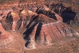
A badlands is a type of dry terrain
where softer sedimentary rocks and clay
-rich soil
s have been extensively eroded
by wind
and water
. It can resemble malpaís
, a terrain of volcanic rock. Canyon
s, ravine
s, gullies
, hoodoo
s and other such geological forms are common in badlands. They are often difficult to navigate by foot. Badlands often have a spectacular color display that alternates from dark black/blue coal stria to bright clays to red scoria
.
Some of the most famous fossil
beds are found in badlands, where erosion rapidly exposes the sediment
ary layers and the scant cover of vegetation
makes surveying
and fossil hunting relatively easy.
Coal seams are also exposed in some badlands, so historically, coal mining districts have developed in badlands areas. An example of this is the Drumheller district of the Red Deer River
in Alberta, where the Atlas Coal Mines historical site preserves the last of 139 mines that operated in those badlands.
and Canada
. In the U.S., Makoshika State Park
in Montana
, Theodore Roosevelt National Park
in North Dakota
and Badlands National Park
in South Dakota
together form a series of extensive badland formations. Another popular area of badland formations is Toadstool Geologic Park
in the Oglala National Grassland
of northwestern Nebraska
. Dinosaur National Monument
in Colorado and Utah are also badlands settings. A small badland called Hell's Half-Acre
is present in Natrona County, Wyoming
. Additional badlands also exist in various places throughout southwest Wyoming, such as near Pinedale
and in the Bridger Valley near the towns of Lyman
and Mountain View, near the high Uintah Mountains.
The Big Muddy Badlands
in Saskatchewan
, Canada, gained notoriety as a hideout for outlaw
s. There is a large badland area in Alberta
, Canada, particularly in the valley of the Red Deer River
where Dinosaur Provincial Park
is located. The Royal Tyrrell Museum of Palaeontology
in Drumheller, Alberta
.
Arguably the most well known badlands formation in New Zealand
, the Putangirua Pinnacles – formed by the erosion of the conglomerate
of an old alluvial fan – are located at the head of a small valley near the southern tip of the North island
.
The Bardenas Reales
near Tudela
, Spain
is an example in Europe.
Although most badland scenery is natural, there are some examples produced by mining, such as the Roman
gold mine of Las Médulas
in northern Spain
. An example of badlands produced by poor farming practices is the Cheltenham Badlands
in Caledon Hills, Ontario
.
Terrain
Terrain, or land relief, is the vertical and horizontal dimension of land surface. When relief is described underwater, the term bathymetry is used...
where softer sedimentary rocks and clay
Clay
Clay is a general term including many combinations of one or more clay minerals with traces of metal oxides and organic matter. Geologic clay deposits are mostly composed of phyllosilicate minerals containing variable amounts of water trapped in the mineral structure.- Formation :Clay minerals...
-rich soil
Soil
Soil is a natural body consisting of layers of mineral constituents of variable thicknesses, which differ from the parent materials in their morphological, physical, chemical, and mineralogical characteristics...
s have been extensively eroded
Erosion
Erosion is when materials are removed from the surface and changed into something else. It only works by hydraulic actions and transport of solids in the natural environment, and leads to the deposition of these materials elsewhere...
by wind
Wind
Wind is the flow of gases on a large scale. On Earth, wind consists of the bulk movement of air. In outer space, solar wind is the movement of gases or charged particles from the sun through space, while planetary wind is the outgassing of light chemical elements from a planet's atmosphere into space...
and water
Water
Water is a chemical substance with the chemical formula H2O. A water molecule contains one oxygen and two hydrogen atoms connected by covalent bonds. Water is a liquid at ambient conditions, but it often co-exists on Earth with its solid state, ice, and gaseous state . Water also exists in a...
. It can resemble malpaís
Malpaís (landform)
A malpaís is a landform characterized by eroded rocks of volcanic origin in an arid environment. This describes many xeric places, but is strongly connected to Spanish-speaking countries and the Southwestern United States because of the Spanish settlers that gave the landform its name.-Badlands...
, a terrain of volcanic rock. Canyon
Canyon
A canyon or gorge is a deep ravine between cliffs often carved from the landscape by a river. Rivers have a natural tendency to reach a baseline elevation, which is the same elevation as the body of water it will eventually drain into. This forms a canyon. Most canyons were formed by a process of...
s, ravine
Ravine
A ravine is a landform narrower than a canyon and is often the product of streamcutting erosion. Ravines are typically classified as larger in scale than gullies, although smaller than valleys. A ravine is generally a fluvial slope landform of relatively steep sides, on the order of twenty to...
s, gullies
Gully
A gully is a landform created by running water, eroding sharply into soil, typically on a hillside. Gullies resemble large ditches or small valleys, but are metres to tens of metres in depth and width...
, hoodoo
Hoodoo (geology)
A hoodoo is a tall, thin spire of rock that protrudes from the bottom of an arid drainage basin or badland. Hoodoos consist of relatively soft rock topped by harder, less easily eroded stone that protects each column from the elements...
s and other such geological forms are common in badlands. They are often difficult to navigate by foot. Badlands often have a spectacular color display that alternates from dark black/blue coal stria to bright clays to red scoria
Scoria
Scoria is a volcanic rock containing many holes or vesicles. It is most generally dark in color , and basaltic or andesitic in composition. Scoria is relatively low in mass as a result of its numerous macroscopic ellipsoidal vesicles, but in contrast to pumice, all scoria has a specific gravity...
.
Features
The term badlands represents a consensus in North America. The Lakota called the topography "Makhóšiča", literally bad land, while French trappers called it "les mauvaises terres à traverser" – "the bad lands to cross". The Spanish called it tierra baldía ("waste land") and cárcava ("gully"). The term badlands is also apt: badlands contain steep slopes, loose dry soil, slick clay, and deep sand, all of which impede travel and other uses. Badlands form in semi-arid or arid regions with infrequent but intense rain-showers, sparse vegetation, and soft sediments: a recipe for massive erosion.Some of the most famous fossil
Fossil
Fossils are the preserved remains or traces of animals , plants, and other organisms from the remote past...
beds are found in badlands, where erosion rapidly exposes the sediment
Sediment
Sediment is naturally occurring material that is broken down by processes of weathering and erosion, and is subsequently transported by the action of fluids such as wind, water, or ice, and/or by the force of gravity acting on the particle itself....
ary layers and the scant cover of vegetation
Vegetation
Vegetation is a general term for the plant life of a region; it refers to the ground cover provided by plants. It is a general term, without specific reference to particular taxa, life forms, structure, spatial extent, or any other specific botanical or geographic characteristics. It is broader...
makes surveying
Surveying
See Also: Public Land Survey SystemSurveying or land surveying is the technique, profession, and science of accurately determining the terrestrial or three-dimensional position of points and the distances and angles between them...
and fossil hunting relatively easy.
Coal seams are also exposed in some badlands, so historically, coal mining districts have developed in badlands areas. An example of this is the Drumheller district of the Red Deer River
Red Deer River
The Red Deer River is a river in Alberta, Canada. It is a major tributary of the South Saskatchewan River.Red Deer River has a total length of and a drainage area of...
in Alberta, where the Atlas Coal Mines historical site preserves the last of 139 mines that operated in those badlands.
Locations
Some of the best-known badland formations can be found in the United StatesUnited States
The United States of America is a federal constitutional republic comprising fifty states and a federal district...
and Canada
Canada
Canada is a North American country consisting of ten provinces and three territories. Located in the northern part of the continent, it extends from the Atlantic Ocean in the east to the Pacific Ocean in the west, and northward into the Arctic Ocean...
. In the U.S., Makoshika State Park
Makoshika State Park
Makoshika State Park is the largest of Montana's state parks at more than 11,000 acres . It is located east of Glendive. The park contains spectacular badlands which conceal dinosaur fossils. The park contains rock from the Hell Creek Formation and dinosaurs such as Triceratops are found there...
in Montana
Montana
Montana is a state in the Western United States. The western third of Montana contains numerous mountain ranges. Smaller, "island ranges" are found in the central third of the state, for a total of 77 named ranges of the Rocky Mountains. This geographical fact is reflected in the state's name,...
, Theodore Roosevelt National Park
Theodore Roosevelt National Park
Theodore Roosevelt National Park is a United States National Park comprising three geographically separated areas of badlands in western North Dakota. The park was named for U.S. President Theodore Roosevelt, in honor of his achievements in conservation as president and for the landscape's...
in North Dakota
North Dakota
North Dakota is a state located in the Midwestern region of the United States of America, along the Canadian border. The state is bordered by Canada to the north, Minnesota to the east, South Dakota to the south and Montana to the west. North Dakota is the 19th-largest state by area in the U.S....
and Badlands National Park
Badlands National Park
Badlands National Park, in southwest South Dakota, United States preserves of sharply eroded buttes, pinnacles, and spires blended with the largest protected mixed grass prairie in the United States....
in South Dakota
South Dakota
South Dakota is a state located in the Midwestern region of the United States. It is named after the Lakota and Dakota Sioux American Indian tribes. Once a part of Dakota Territory, South Dakota became a state on November 2, 1889. The state has an area of and an estimated population of just over...
together form a series of extensive badland formations. Another popular area of badland formations is Toadstool Geologic Park
Toadstool Geologic Park
Toadstool Geologic Park is located in the Oglala National Grassland in far northwestern Nebraska. It is operated by the United States Forest Service. It contains a badlands landscape and a reconstructed sod house...
in the Oglala National Grassland
Oglala National Grassland
The Oglala National Grassland is a United States National Grassland in the northwest corner of Nebraska. It is in northern Sioux and northwestern Dawes counties, on the borders with South Dakota and Wyoming...
of northwestern Nebraska
Nebraska
Nebraska is a state on the Great Plains of the Midwestern United States. The state's capital is Lincoln and its largest city is Omaha, on the Missouri River....
. Dinosaur National Monument
Dinosaur National Monument
Dinosaur National Monument is a National Monument located on the southeast flank of the Uinta Mountains on the border between Colorado and Utah at the confluence of the Green and Yampa Rivers. Although most of the monument area is in Moffat County, Colorado, the Dinosaur Quarry is located in Utah...
in Colorado and Utah are also badlands settings. A small badland called Hell's Half-Acre
Hell's Half Acre (Wyoming)
Hell's Half Acre is a large scarp located about west of Casper, Wyoming on US 20/26. Encompassing , this geologic oddity is composed of deep ravines, caves, rock formations and hard-packed eroded earth...
is present in Natrona County, Wyoming
Wyoming
Wyoming is a state in the mountain region of the Western United States. The western two thirds of the state is covered mostly with the mountain ranges and rangelands in the foothills of the Eastern Rocky Mountains, while the eastern third of the state is high elevation prairie known as the High...
. Additional badlands also exist in various places throughout southwest Wyoming, such as near Pinedale
Pinedale, Wyoming
Pinedale is a town in and the county seat of Sublette County, Wyoming, United States. The population was 1,412 at the 2000 census. Pinedale is an important hunting outfitting town and a gateway to the Wind River Mountains. It is also a major gateway to the Jackson Hole area in Wyoming. Pinedale is...
and in the Bridger Valley near the towns of Lyman
Lyman, Wyoming
Lyman is a town in Uinta County, Wyoming, United States. The population was 1,938 at the 2000 census.-Geography:Lyman is located at ....
and Mountain View, near the high Uintah Mountains.
The Big Muddy Badlands
Big Muddy Badlands
The Big Muddy Badlands are a series of badlands in southern Saskatchewan and northern Montana along Big Muddy Creek. They are found in the Big Muddy Valley, a cleft of erosion and sandstone along Big Muddy Creek. The valley is long, wide and deep...
in Saskatchewan
Saskatchewan
Saskatchewan is a prairie province in Canada, which has an area of . Saskatchewan is bordered on the west by Alberta, on the north by the Northwest Territories, on the east by Manitoba, and on the south by the U.S. states of Montana and North Dakota....
, Canada, gained notoriety as a hideout for outlaw
Outlaw
In historical legal systems, an outlaw is declared as outside the protection of the law. In pre-modern societies, this takes the burden of active prosecution of a criminal from the authorities. Instead, the criminal is withdrawn all legal protection, so that anyone is legally empowered to persecute...
s. There is a large badland area in Alberta
Alberta
Alberta is a province of Canada. It had an estimated population of 3.7 million in 2010 making it the most populous of Canada's three prairie provinces...
, Canada, particularly in the valley of the Red Deer River
Red Deer River
The Red Deer River is a river in Alberta, Canada. It is a major tributary of the South Saskatchewan River.Red Deer River has a total length of and a drainage area of...
where Dinosaur Provincial Park
Dinosaur Provincial Park
Dinosaur Provincial Park is a UNESCO World Heritage Site located about two and a half hours drive southeast of Calgary, Alberta, Canada or , about a half hour drive, northeast of Brooks....
is located. The Royal Tyrrell Museum of Palaeontology
Royal Tyrrell Museum of Palaeontology
The Royal Tyrrell Museum is a popular Canadian tourist attraction and a leading centre of palaeontological research noted for its collection of more than 130,000 fossils....
in Drumheller, Alberta
Drumheller, Alberta
Drumheller is a town within the Red Deer River valley in the badlands of east-central Alberta, Canada. It is located northeast of Calgary...
.
Arguably the most well known badlands formation in New Zealand
New Zealand
New Zealand is an island country in the south-western Pacific Ocean comprising two main landmasses and numerous smaller islands. The country is situated some east of Australia across the Tasman Sea, and roughly south of the Pacific island nations of New Caledonia, Fiji, and Tonga...
, the Putangirua Pinnacles – formed by the erosion of the conglomerate
Conglomerate (geology)
A conglomerate is a rock consisting of individual clasts within a finer-grained matrix that have become cemented together. Conglomerates are sedimentary rocks consisting of rounded fragments and are thus differentiated from breccias, which consist of angular clasts...
of an old alluvial fan – are located at the head of a small valley near the southern tip of the North island
North Island
The North Island is one of the two main islands of New Zealand, separated from the much less populous South Island by Cook Strait. The island is in area, making it the world's 14th-largest island...
.
The Bardenas Reales
Bardenas Reales
The Bardenas Reales is a semi-desert of some 42,000 ha in southeast Navarre . The soils are made up of clay, chalk and sandstone and have been eroded by water and wind creating surprising shapes, canyons, plateaus, tabular structures and isolated hills, called seamounts...
near Tudela
Tudela, Navarre
Tudela is a municipality in Spain, the second city of the autonomous community of Navarre. Its population is around 35,000. Tudela is sited in the Ebro valley. Fast trains running on two-track electrified railways serve the city and two freeways join close to it...
, Spain
Spain
Spain , officially the Kingdom of Spain languages]] under the European Charter for Regional or Minority Languages. In each of these, Spain's official name is as follows:;;;;;;), is a country and member state of the European Union located in southwestern Europe on the Iberian Peninsula...
is an example in Europe.
Although most badland scenery is natural, there are some examples produced by mining, such as the Roman
Ancient Rome
Ancient Rome was a thriving civilization that grew on the Italian Peninsula as early as the 8th century BC. Located along the Mediterranean Sea and centered on the city of Rome, it expanded to one of the largest empires in the ancient world....
gold mine of Las Médulas
Las Médulas
Las Médulas is a historical site near the town of Ponferrada in the region of El Bierzo , which used to be the most important gold mine in the Roman Empire...
in northern Spain
Spain
Spain , officially the Kingdom of Spain languages]] under the European Charter for Regional or Minority Languages. In each of these, Spain's official name is as follows:;;;;;;), is a country and member state of the European Union located in southwestern Europe on the Iberian Peninsula...
. An example of badlands produced by poor farming practices is the Cheltenham Badlands
Cheltenham Badlands
Cheltenham Badlands is a small example of Badlands formation in Caledon, Ontario.The site is located on the southside of Old Base Line Road and features exposed and eroded Queenston Shale...
in Caledon Hills, Ontario
Ontario
Ontario is a province of Canada, located in east-central Canada. It is Canada's most populous province and second largest in total area. It is home to the nation's most populous city, Toronto, and the nation's capital, Ottawa....
.
See also
- Badlands National ParkBadlands National ParkBadlands National Park, in southwest South Dakota, United States preserves of sharply eroded buttes, pinnacles, and spires blended with the largest protected mixed grass prairie in the United States....
, South Dakota - GeomorphologyGeomorphologyGeomorphology is the scientific study of landforms and the processes that shape them...
- Badlands GuardianBadlands GuardianThe Badlands Guardian is a geomorphological feature located near Medicine Hat in the south east corner of Alberta, Canada. Viewed from the air, the feature bears a strong resemblance to a human head wearing a full native American headdress, facing directly westward. Because of additional man-made...