
.gif)
Panther Mountain (New York)
Encyclopedia
Panther Mountain is one of the Catskill
High Peaks
, located in the Town of Shandaken
in Ulster County
, New York
. At approximately 3,720 feet (1,135 m) in elevation, it is the 18th highest in the range. A combination of factors has led geologists
to believe the mountain is on the site of an ancient meteorite
impact crater
.
Its proximity to Slide Mountain
, the highest Catskill peak, the relatively short distance required to climb the mountain from the south and the excellent views available from the mountain and nearby Giant Ledge have made Panther one of the most popular hikes
in the range. Aspiring members of the Catskill Mountain 3500 Club
must climb it twice, at least once during winter.
s may once have been seen in the area; but are not resident in the Catskills today.
and Woodland creeks. Slide's
north ridge begins right where the Panther/Giant Ledge ridge ends. Two named tributaries
of Woodland, its Dougherty Branch and Panther Kill, rise on the mountain's western slopes.
Three of the valley
s around the edge of the mountain have earned separate names of their own. Going clockwise
from the southwest, they are Little Peck Hollow, Hatchery Hollow and Fox Hollow. The ridge aside the Daugherty Branch is called Fork Ridge.
The mountain rises gradually from the north, with many false summits
. The drop to the south, to the col
with Giant Ledge, is much sharper.
The entire area has long been a part of New York's Forest Preserve
. Today it is within the Slide Mountain Wilderness Area
, part of the Catskill Park, managed by the state Department of Environmental Conservation
.
s show a more dendritic (tree-like) pattern rather than the rosette
made by Esopus and Woodland creeks around the mountain.
In the 1940s, geologist George Chadwick noticed this dome
structure, and concluded that it might be the result of gas pushing up from below. The Dome Gas Company drilled a 6,000 feet (1.8 km) well into the structure. This well produced roughly 50,000 cubic feet (150 m³) of natural gas
a day, but since that was not profitable, the effort was abandoned.
In the early 1970s, another geologist, Yngvar Isachsen of the New York State Geological Survey at the New York State Museum
in Albany
, wondered if the stream pattern indicated an impact crater
buried beneath the surface. Since it wasn't his primary task at the Geological Survey, Isachsen did most of his research into the crater question in his own time. He found, when looking at the bed of Esopus Creek, that much of the exposed sandstone
and shale
showed an unusually closely spaced fracture
pattern — every foot (30 cm) instead of every meter (3.3 ft), as is seen elsewhere in the Catskills. He reasoned that if a crater wall lay beneath, the debris from the impact and the sedimentary rock
already in the area would have settled more compactly and been more prone to sagging and fracturing over time.
It wasn't until his later years, in the early 1990s, that Isachsen was able to devote more time to the crater question. Since the walls of a newly-formed impact crater are often unable to support themselves, landslide
s occur and build up a mound of rock and soil in the center. This results in a lower density
of rock and thus slightly reduced gravitation
al pull, which can be measured. Isachsen took a gravimeter
along on two hikes up the mountain and took regular readings. As he had expected, the gravity in the area was slightly lower than other mountains of comparable elevation in the Catskills, adding more weight to the crater theory.
To prove his hypothesis, Isachsen needed to drill deep into the rock under the mountain and find direct mineral evidence of a meteorite strike, but this was beyond his resources. Then he discovered that drill cuttings
from the earlier gas well were archived at the New York State Geological Survey museum. These cuttings were examined carefully, during which graduate students working for him found microscopic iron
spherules — to him irrefutable evidence of an impact crater.
However, questions from crater specialists at a conference
in Budapest
sent him back to look more closely at the cuttings. One attendee pointed out that he hadn't ruled out the possibility that the spherules had merely been deposited by a passing meteorite or comet
. In October 1999, closer examination of tiny quartz
crystals in the samples turned up shock lamellae
, which could only have resulted from impact. A group of Canadian
specialists confirmed the finding.
The impact is estimated to have occurred 375 million years ago, during the Devonian
period, when much of what is now the Catskills was either river delta
or a shallow sea. The crater lies 2,640 feet (800 m) below the surface, is 6 miles (10 km) wide, and lies directly under the mountain. The meteorite that struck is believed to have been roughly one-half mile (1 km) wide, striking with a force equivalent to 11 trillion tons (9.9 trillion tonnes) of TNT.
Isachsen believes it is possible that there may be significant hydrocarbon
deposits, often associated with ancient buried impact craters, very deep beneath the mountain.
In 2004, the European Space Agency
's Mars Express
probe found an analogous circular plateau in the Solis Planum region of the Thaumasia Planum area of Mars
. While it has not yet eroded
as Panther has, both are an example of inverted relief
.
-birch
-maple
northern hardwood
forests on its lower slopes giving way to boreal forests of balsam fir
and red spruce
above 3500 feet (1,066.8 m) on the mountain. While the lower slopes were logged in the 19th century, particularly for Eastern hemlock
bark and its tannin
, the upper mountain remains in first growth. According to Catskill forest historian Michael Kudish
, there is a rare virgin spruce grove near the summit. There are also two open areas visible from the summit on a knob known as Beech Flat, one of about two acres (8,000 m²) at 2,740 feet (835 m) and another of 5–7 acres (2–3 ha) at 2,848 feet (868 m), are totally natural, resulting from the absence of soil in those areas.
The proximity of the railroad led to another common Catskill industry of the time, bluestone
quarry
ing. Kudish has found several along the northern edge of the mountain and suspects there may be more.
The Fox Hollow-Panther-Giant Ledge Trail across the mountain used by hikers to reach the summit today was cut in 1935, based on a contemporary Conservation Department pamphlet. The Fox Hollow Lean-To was built the next year.
Fox Hollow-Panther-Giant Ledge Trail (GP), which runs north-south from Fox Hollow down to a junction with the yellow-blazed Phoenicia-East Branch (P-EB) Trail 0.5 mile (1 km) south of Giant Ledge. The vast majority of attempts on the mountain use this route.
 The shorter southern approach is much more popular due not only to its brevity but the excellent views available from Giant Ledge. The northern approach, however, is not without some views of its own. Sometimes the entire 7.5-mile (12 km) GP trail, plus the route to the Giant Ledge trailhead or Woodland Valley State Campground, will be hiked as an overnight backpack
, with one of the designated campsite
s along the trail being use, and cars parked at both ends.
lot, 2,100 feet (641 m) in elevation, where Ulster County Route 47 bends sharply about three-quarters of a mile (1.3 km) north of Winnisook Lake
, midway up or down the hill between it and Big Indian Hollow. Here the P-EB leaves the road again and leads southeast uphill 0.7 mile (1.1 km) and 500 vertical feet (150 m) to the GP in the level area between the ledge and Slide's north ridge. The former route of the P-EB, now closed, leads downhill to the southwest to its former route across the Winnisook Club.
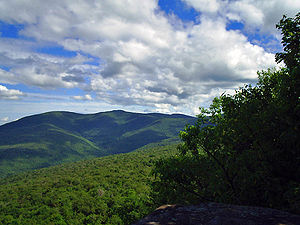
Turning north on the GP, the trail remains level, passing an official campsite
and some muddy spots until it reaches the base of Giant Ledge 0.6 mile (1 km) later, where a good, reliable spring
can be found via a short side trail. A climb of 0.15 mile (240 m) up the steep, rocky south slope of the ledge, sometimes assisted by rock steps, levels out at 3,200 feet (975 m), where the trail stays close to the east side. There are many viewpoints from the cliff
tops here that take in the nearby Burroughs Range (Slide, Wittenberg and Cornell) to the south; the valley of Woodland Creek below with a small area of Ashokan Reservoir
; and the Devil's Path
to the northeast. There are more campsites, often likely to be taken early on good summer weekends.
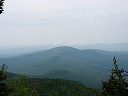
 The trail remains on the ledge for 0.3 mile (500 m), then drops down again more gently on the north slope. Not too long after reaching level ground, the 720-foot (219 m) climb up Panther proper begins. At first the trail gently switches back up some rocky stretches of the mountain's south slope, then at 0.75 miles (1.2 km) from the ledge, a short side trail leads to an excellent viewpoint over the Burroughs Range at about 3,300 feet (1,000 m). Another 0.2 mile (400 m) further, the trail passes a grassy area that has been home to a less reliable spring in the past. Not too far beyond, in the middle of two steep, rocky chutes, the trail passes the sign marking 3,500 feet (1,067 m) in elevation, above which open fires are forbidden and camping is only permitted in winter, due to the fragile high-montane environment. The trail levels off gently but there is still almost 0.5 mile (1 km) to the small ledge with a view to the northeast that marks the summit.
Via this route, it is 3.2 miles (5.1 km) to the summit. Total vertical gain is 1,920 feet (585 m); net is 1,720 feet (524 m), due to the presence of Giant Ledge along the trail. However, some more experienced hikers sometimes bushwhack around the base of the ledge to save themselves this extra vertical if they do not want to take in the views.
at 1,420 feet (433 m) in elevation. At 0.4 mile (640 m) from that trailhead, a short side trail leads to the Fox Hollow lean-to
and a reliable spring.
The trail then begins to climb the long ridge of Panther, finally reaching the first (3,480-foot; 1,061 m) of two false summits after 2.7 miles (4.3 km). A short descent follows, then another climb to the second false summit 0.6 mile (1 km) to the south. Along the way there is an excellent view of the peaks to the west: Balsam
, Fir
and Big Indian
. It is another 1.2 mile (1.9 km) and a steeper climb to the actual summit.
Total distance via this route is 4.9 miles (7.9 km). Total vertical ascent is 2,450 feet (747 m).
Catskill Mountains
The Catskill Mountains, an area in New York State northwest of New York City and southwest of Albany, are a mature dissected plateau, an uplifted region that was subsequently eroded into sharp relief. They are an eastward continuation, and the highest representation, of the Allegheny Plateau...
High Peaks
Catskill High Peaks
The Catskill High Peaks are all of the mountains in New York's Catskill Mountains above 3,500 ft in elevation whose summits are separated either by one-half mile or a vertical drop of at least 250 ft between it and the next nearest separate summit...
, located in the Town of Shandaken
Shandaken, New York
Shandaken is a town in Ulster County, New York, United States. United States. As of the 2000 census, the town had a total population of 3,235. The name is from a native phrase for "land of rapid waters."...
in Ulster County
Ulster County, New York
Ulster County is a county located in the state of New York, USA. It sits in the state's Mid-Hudson Region of the Hudson Valley. As of the 2010 census, the population was 182,493. Recent population estimates completed by the United States Census Bureau for the 12-month period ending July 1 are at...
, New York
New York
New York is a state in the Northeastern region of the United States. It is the nation's third most populous state. New York is bordered by New Jersey and Pennsylvania to the south, and by Connecticut, Massachusetts and Vermont to the east...
. At approximately 3,720 feet (1,135 m) in elevation, it is the 18th highest in the range. A combination of factors has led geologists
Geology
Geology is the science comprising the study of solid Earth, the rocks of which it is composed, and the processes by which it evolves. Geology gives insight into the history of the Earth, as it provides the primary evidence for plate tectonics, the evolutionary history of life, and past climates...
to believe the mountain is on the site of an ancient meteorite
Meteorite
A meteorite is a natural object originating in outer space that survives impact with the Earth's surface. Meteorites can be big or small. Most meteorites derive from small astronomical objects called meteoroids, but they are also sometimes produced by impacts of asteroids...
impact crater
Impact crater
In the broadest sense, the term impact crater can be applied to any depression, natural or manmade, resulting from the high velocity impact of a projectile with a larger body...
.
Its proximity to Slide Mountain
Slide Mountain (New York)
Slide Mountain is the highest peak in the Catskills. It is located in the Town of Shandaken in Ulster County, in southern New York. While the contour line on topographic maps is generally accepted as its height, the exact elevation of the summit has never been officially determined by the U.S...
, the highest Catskill peak, the relatively short distance required to climb the mountain from the south and the excellent views available from the mountain and nearby Giant Ledge have made Panther one of the most popular hikes
Hiking
Hiking is an outdoor activity which consists of walking in natural environments, often in mountainous or other scenic terrain. People often hike on hiking trails. It is such a popular activity that there are numerous hiking organizations worldwide. The health benefits of different types of hiking...
in the range. Aspiring members of the Catskill Mountain 3500 Club
Catskill Mountain 3500 Club
The Catskill Mountain 3500 Club, incorporated as the Catskill 3500 Club and often just referred to as the 3500 Club, is a peakbagging organization for hikers in the Catskill Mountains of New York...
must climb it twice, at least once during winter.
Name
The origin of the name is unknown. PantherPanthera
Panthera is a genus of the family Felidae , which contains four well-known living species: the tiger, the lion, the jaguar, and the leopard. The genus comprises about half of the Pantherinae subfamily, the big cats...
s may once have been seen in the area; but are not resident in the Catskills today.
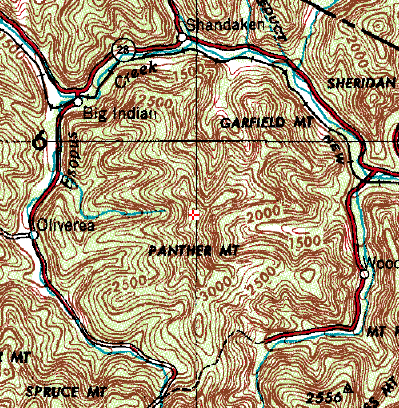
Geography
The mountain takes the shape of a longitudinal ridge in the center of the rough circle mostly formed by EsopusEsopus Creek
Esopus Creek is a tributary of the Hudson River that drains the east-central Catskill Mountains of the U.S. state of New York. From its source at Winnisook Lake on the slopes of Slide Mountain, the Catskills' highest peak, it flows across Ulster County to the Hudson at Saugerties. Many tributaries...
and Woodland creeks. Slide's
Slide Mountain (New York)
Slide Mountain is the highest peak in the Catskills. It is located in the Town of Shandaken in Ulster County, in southern New York. While the contour line on topographic maps is generally accepted as its height, the exact elevation of the summit has never been officially determined by the U.S...
north ridge begins right where the Panther/Giant Ledge ridge ends. Two named tributaries
Tributary
A tributary or affluent is a stream or river that flows into a main stem river or a lake. A tributary does not flow directly into a sea or ocean...
of Woodland, its Dougherty Branch and Panther Kill, rise on the mountain's western slopes.
Three of the valley
Valley
In geology, a valley or dale is a depression with predominant extent in one direction. A very deep river valley may be called a canyon or gorge.The terms U-shaped and V-shaped are descriptive terms of geography to characterize the form of valleys...
s around the edge of the mountain have earned separate names of their own. Going clockwise
Clockwise
Circular motion can occur in two possible directions. A clockwise motion is one that proceeds in the same direction as a clock's hands: from the top to the right, then down and then to the left, and back to the top...
from the southwest, they are Little Peck Hollow, Hatchery Hollow and Fox Hollow. The ridge aside the Daugherty Branch is called Fork Ridge.
The mountain rises gradually from the north, with many false summits
Summit (topography)
In topography, a summit is a point on a surface that is higher in elevation than all points immediately adjacent to it. Mathematically, a summit is a local maximum in elevation...
. The drop to the south, to the col
Mountain pass
A mountain pass is a route through a mountain range or over a ridge. If following the lowest possible route, a pass is locally the highest point on that route...
with Giant Ledge, is much sharper.
The entire area has long been a part of New York's Forest Preserve
Forest Preserve (New York)
New York's Forest Preserve is all the land owned by the state within the Adirondack and Catskill parks, managed by its Department of Environmental Conservation. These properties are required to be kept "forever wild" by Article 14 of the state constitution, and thus enjoy the highest degree of...
. Today it is within the Slide Mountain Wilderness Area
Slide Mountain Wilderness Area
The Slide Mountain Wilderness Area is, at 47,500 acres , the largest tract of state-owned Forest Preserve in New York's Catskill Park, and the largest area under any kind of wilderness area protection between the Adirondacks and the southern Appalachians...
, part of the Catskill Park, managed by the state Department of Environmental Conservation
New York State Department of Environmental Conservation
The New York State Department of Environmental Conservation is responsible for the conservation, improvement, and protection of natural resources within the U.S. state of New York. It was founded in 1970, replacing the previous Conservation Department...
.
Geology
The circular pattern made by the two creeks surrounding Panther Mountain suggest that it might have a different origin from other Catskill peaks. Most mountains' drainage basinDrainage basin
A drainage basin is an extent or an area of land where surface water from rain and melting snow or ice converges to a single point, usually the exit of the basin, where the waters join another waterbody, such as a river, lake, reservoir, estuary, wetland, sea, or ocean...
s show a more dendritic (tree-like) pattern rather than the rosette
Rosette
-People:* Rosette , a French actress* Rosette Bir , a French sculptor* Clinton Rosette , a prominent citizen of DeKalb, Illinois...
made by Esopus and Woodland creeks around the mountain.
In the 1940s, geologist George Chadwick noticed this dome
Dome
A dome is a structural element of architecture that resembles the hollow upper half of a sphere. Dome structures made of various materials have a long architectural lineage extending into prehistory....
structure, and concluded that it might be the result of gas pushing up from below. The Dome Gas Company drilled a 6,000 feet (1.8 km) well into the structure. This well produced roughly 50,000 cubic feet (150 m³) of natural gas
Natural gas
Natural gas is a naturally occurring gas mixture consisting primarily of methane, typically with 0–20% higher hydrocarbons . It is found associated with other hydrocarbon fuel, in coal beds, as methane clathrates, and is an important fuel source and a major feedstock for fertilizers.Most natural...
a day, but since that was not profitable, the effort was abandoned.
In the early 1970s, another geologist, Yngvar Isachsen of the New York State Geological Survey at the New York State Museum
New York State Museum
The New York State Museum is a research-backed institution in Albany, New York, United States. It is located on Madison Avenue, attached to the south side of the Empire State Plaza, facing onto the plaza and towards the New York State Capitol...
in Albany
Albany, New York
Albany is the capital city of the U.S. state of New York, the seat of Albany County, and the central city of New York's Capital District. Roughly north of New York City, Albany sits on the west bank of the Hudson River, about south of its confluence with the Mohawk River...
, wondered if the stream pattern indicated an impact crater
Impact crater
In the broadest sense, the term impact crater can be applied to any depression, natural or manmade, resulting from the high velocity impact of a projectile with a larger body...
buried beneath the surface. Since it wasn't his primary task at the Geological Survey, Isachsen did most of his research into the crater question in his own time. He found, when looking at the bed of Esopus Creek, that much of the exposed sandstone
Sandstone
Sandstone is a sedimentary rock composed mainly of sand-sized minerals or rock grains.Most sandstone is composed of quartz and/or feldspar because these are the most common minerals in the Earth's crust. Like sand, sandstone may be any colour, but the most common colours are tan, brown, yellow,...
and shale
Shale
Shale is a fine-grained, clastic sedimentary rock composed of mud that is a mix of flakes of clay minerals and tiny fragments of other minerals, especially quartz and calcite. The ratio of clay to other minerals is variable. Shale is characterized by breaks along thin laminae or parallel layering...
showed an unusually closely spaced fracture
Fracture
A fracture is the separation of an object or material into two, or more, pieces under the action of stress.The word fracture is often applied to bones of living creatures , or to crystals or crystalline materials, such as gemstones or metal...
pattern — every foot (30 cm) instead of every meter (3.3 ft), as is seen elsewhere in the Catskills. He reasoned that if a crater wall lay beneath, the debris from the impact and the sedimentary rock
Sedimentary rock
Sedimentary rock are types of rock that are formed by the deposition of material at the Earth's surface and within bodies of water. Sedimentation is the collective name for processes that cause mineral and/or organic particles to settle and accumulate or minerals to precipitate from a solution....
already in the area would have settled more compactly and been more prone to sagging and fracturing over time.
It wasn't until his later years, in the early 1990s, that Isachsen was able to devote more time to the crater question. Since the walls of a newly-formed impact crater are often unable to support themselves, landslide
Landslide
A landslide or landslip is a geological phenomenon which includes a wide range of ground movement, such as rockfalls, deep failure of slopes and shallow debris flows, which can occur in offshore, coastal and onshore environments...
s occur and build up a mound of rock and soil in the center. This results in a lower density
Density
The mass density or density of a material is defined as its mass per unit volume. The symbol most often used for density is ρ . In some cases , density is also defined as its weight per unit volume; although, this quantity is more properly called specific weight...
of rock and thus slightly reduced gravitation
Gravitation
Gravitation, or gravity, is a natural phenomenon by which physical bodies attract with a force proportional to their mass. Gravitation is most familiar as the agent that gives weight to objects with mass and causes them to fall to the ground when dropped...
al pull, which can be measured. Isachsen took a gravimeter
Gravimeter
A gravimeter or gravitometer is an instrument used in gravimetry for measuring the local gravitational field of the Earth. A gravimeter is a type of accelerometer, specialized for measuring the constant downward acceleration of gravity, which varies by about 0.5% over the surface of the Earth...
along on two hikes up the mountain and took regular readings. As he had expected, the gravity in the area was slightly lower than other mountains of comparable elevation in the Catskills, adding more weight to the crater theory.
To prove his hypothesis, Isachsen needed to drill deep into the rock under the mountain and find direct mineral evidence of a meteorite strike, but this was beyond his resources. Then he discovered that drill cuttings
Drill cuttings
Drill cuttings are the broken bits of solid material removed from a borehole drilled by rotary, percussion, or auger methods. Boreholes drilled in this way include oil or gas wells, water wells, and holes drilled for geotechnical investigations or mineral exploration.The drill cuttings are commonly...
from the earlier gas well were archived at the New York State Geological Survey museum. These cuttings were examined carefully, during which graduate students working for him found microscopic iron
Iron
Iron is a chemical element with the symbol Fe and atomic number 26. It is a metal in the first transition series. It is the most common element forming the planet Earth as a whole, forming much of Earth's outer and inner core. It is the fourth most common element in the Earth's crust...
spherules — to him irrefutable evidence of an impact crater.
However, questions from crater specialists at a conference
Academic conference
An academic conference or symposium is a conference for researchers to present and discuss their work. Together with academic or scientific journals, conferences provide an important channel for exchange of information between researchers.-Overview:Conferences are usually composed of various...
in Budapest
Budapest
Budapest is the capital of Hungary. As the largest city of Hungary, it is the country's principal political, cultural, commercial, industrial, and transportation centre. In 2011, Budapest had 1,733,685 inhabitants, down from its 1989 peak of 2,113,645 due to suburbanization. The Budapest Commuter...
sent him back to look more closely at the cuttings. One attendee pointed out that he hadn't ruled out the possibility that the spherules had merely been deposited by a passing meteorite or comet
Comet
A comet is an icy small Solar System body that, when close enough to the Sun, displays a visible coma and sometimes also a tail. These phenomena are both due to the effects of solar radiation and the solar wind upon the nucleus of the comet...
. In October 1999, closer examination of tiny quartz
Quartz
Quartz is the second-most-abundant mineral in the Earth's continental crust, after feldspar. It is made up of a continuous framework of SiO4 silicon–oxygen tetrahedra, with each oxygen being shared between two tetrahedra, giving an overall formula SiO2. There are many different varieties of quartz,...
crystals in the samples turned up shock lamellae
Lamellae (materials)
A lamella is a gill-shaped structure: fine sheets of material held adjacent to one another, often with fluid in between though sometimes simply a set of 'welded' plates. They appear in biological and engineering contexts, such as filters and heat exchangers...
, which could only have resulted from impact. A group of Canadian
Canada
Canada is a North American country consisting of ten provinces and three territories. Located in the northern part of the continent, it extends from the Atlantic Ocean in the east to the Pacific Ocean in the west, and northward into the Arctic Ocean...
specialists confirmed the finding.
The impact is estimated to have occurred 375 million years ago, during the Devonian
Devonian
The Devonian is a geologic period and system of the Paleozoic Era spanning from the end of the Silurian Period, about 416.0 ± 2.8 Mya , to the beginning of the Carboniferous Period, about 359.2 ± 2.5 Mya...
period, when much of what is now the Catskills was either river delta
River delta
A delta is a landform that is formed at the mouth of a river where that river flows into an ocean, sea, estuary, lake, reservoir, flat arid area, or another river. Deltas are formed from the deposition of the sediment carried by the river as the flow leaves the mouth of the river...
or a shallow sea. The crater lies 2,640 feet (800 m) below the surface, is 6 miles (10 km) wide, and lies directly under the mountain. The meteorite that struck is believed to have been roughly one-half mile (1 km) wide, striking with a force equivalent to 11 trillion tons (9.9 trillion tonnes) of TNT.
Isachsen believes it is possible that there may be significant hydrocarbon
Hydrocarbon
In organic chemistry, a hydrocarbon is an organic compound consisting entirely of hydrogen and carbon. Hydrocarbons from which one hydrogen atom has been removed are functional groups, called hydrocarbyls....
deposits, often associated with ancient buried impact craters, very deep beneath the mountain.
In 2004, the European Space Agency
European Space Agency
The European Space Agency , established in 1975, is an intergovernmental organisation dedicated to the exploration of space, currently with 18 member states...
's Mars Express
Mars Express
Mars Express is a space exploration mission being conducted by the European Space Agency . The Mars Express mission is exploring the planet Mars, and is the first planetary mission attempted by the agency. "Express" originally referred to the speed and efficiency with which the spacecraft was...
probe found an analogous circular plateau in the Solis Planum region of the Thaumasia Planum area of Mars
Mars
Mars is the fourth planet from the Sun in the Solar System. The planet is named after the Roman god of war, Mars. It is often described as the "Red Planet", as the iron oxide prevalent on its surface gives it a reddish appearance...
. While it has not yet eroded
Erosion
Erosion is when materials are removed from the surface and changed into something else. It only works by hydraulic actions and transport of solids in the natural environment, and leads to the deposition of these materials elsewhere...
as Panther has, both are an example of inverted relief
Inverted Relief
Inverted relief is a landscape that is part of a planet's surface, e.g. Mars, that contains positive landforms, i.e. hills and ridges, that were once depressions in its surface...
.
Forests
Panther's forests are for the most part typical of the Catskills, with beechBeech
Beech is a genus of ten species of deciduous trees in the family Fagaceae, native to temperate Europe, Asia and North America.-Habit:...
-birch
Birch
Birch is a tree or shrub of the genus Betula , in the family Betulaceae, closely related to the beech/oak family, Fagaceae. The Betula genus contains 30–60 known taxa...
-maple
Maple
Acer is a genus of trees or shrubs commonly known as maple.Maples are variously classified in a family of their own, the Aceraceae, or together with the Hippocastanaceae included in the family Sapindaceae. Modern classifications, including the Angiosperm Phylogeny Group system, favour inclusion in...
northern hardwood
Hardwood
Hardwood is wood from angiosperm trees . It may also be used for those trees themselves: these are usually broad-leaved; in temperate and boreal latitudes they are mostly deciduous, but in tropics and subtropics mostly evergreen.Hardwood contrasts with softwood...
forests on its lower slopes giving way to boreal forests of balsam fir
Balsam Fir
The balsam fir is a North American fir, native to most of eastern and central Canada and the northeastern United States .-Growth:It is a small to medium-size evergreen tree typically tall, rarely to tall, with a narrow conic crown...
and red spruce
Red Spruce
Picea rubens is a species of spruce native to eastern North America, ranging from eastern Quebec to Nova Scotia, and from New England south in the Adirondack Mountains and Appalachians to western North Carolina.-Physical description:...
above 3500 feet (1,066.8 m) on the mountain. While the lower slopes were logged in the 19th century, particularly for Eastern hemlock
Eastern Hemlock
Tsuga canadensis, also known as eastern or Canadian hemlock, and in the French-speaking regions of Canada as pruche du Canada, is a coniferous tree native to eastern North America. It ranges from northeastern Minnesota eastward through southern Quebec to Nova Scotia, and south in the Appalachian...
bark and its tannin
Tannin
A tannin is an astringent, bitter plant polyphenolic compound that binds to and precipitates proteins and various other organic compounds including amino acids and alkaloids.The term tannin refers to the use of...
, the upper mountain remains in first growth. According to Catskill forest historian Michael Kudish
Michael Kudish
Michael Kudish is an author, railroad historian, forester, and retired professor. He received his Ph.D. in 1971 from the State University of New York College of Environmental Science and Forestry at Syracuse. His dissertation, on the history of Catskill forests, was the beginning of a lifelong...
, there is a rare virgin spruce grove near the summit. There are also two open areas visible from the summit on a knob known as Beech Flat, one of about two acres (8,000 m²) at 2,740 feet (835 m) and another of 5–7 acres (2–3 ha) at 2,848 feet (868 m), are totally natural, resulting from the absence of soil in those areas.
Human history
It is not known who first climbed Panther, due to the sketchy records kept by early inhabitants of the area. Farming, Kudish found, went much lower on Panther (1,613 feet (492 m) on average) than it did elsewhere in the Catskills, due to the steep slopes at the mountain's base. Later logging climbed to a higher elevation, particularly near the hamlets of Big Indian and Phoenicia due to nearby train stations (Garfield Mountain's summit does not appear to be in first growth).The proximity of the railroad led to another common Catskill industry of the time, bluestone
Bluestone
Bluestone is a cultural or commercial name for a number of dimension or building stone varieties, including:*a feldspathic sandstone in the U.S. and Canada;*limestone in the Shenandoah Valley in the U.S...
quarry
Quarry
A quarry is a type of open-pit mine from which rock or minerals are extracted. Quarries are generally used for extracting building materials, such as dimension stone, construction aggregate, riprap, sand, and gravel. They are often collocated with concrete and asphalt plants due to the requirement...
ing. Kudish has found several along the northern edge of the mountain and suspects there may be more.
The Fox Hollow-Panther-Giant Ledge Trail across the mountain used by hikers to reach the summit today was cut in 1935, based on a contemporary Conservation Department pamphlet. The Fox Hollow Lean-To was built the next year.
Approaches
Panther is traversed by the blue-blazedTrail blazing
Trail blazing, or trailblazing, is the practice of marking paths in outdoor recreational areas with blazes, markings that follow each other at certain — though not necessarily exactly defined — distances and mark the direction of the trail...
Fox Hollow-Panther-Giant Ledge Trail (GP), which runs north-south from Fox Hollow down to a junction with the yellow-blazed Phoenicia-East Branch (P-EB) Trail 0.5 mile (1 km) south of Giant Ledge. The vast majority of attempts on the mountain use this route.
Backpacking (wilderness)
Backpacking combines the activities of hiking and camping for an overnight stay in backcountry wilderness...
, with one of the designated campsite
Campsite
A campsite or camping pitch is a place used for overnight stay in the outdoors. In British English a campsite is an area, usually divided into a number of pitches, where people can camp overnight using tents or camper vans or caravans; this British English use of the word is synonymous with the...
s along the trail being use, and cars parked at both ends.
Southern route
Hikers typically park at the trailheadTrailhead
A trailhead is the point at which a trail begins, where the trail is often intended for hiking, biking, horseback riding, or off-road vehicles...
lot, 2,100 feet (641 m) in elevation, where Ulster County Route 47 bends sharply about three-quarters of a mile (1.3 km) north of Winnisook Lake
Winnisook Lake
Winnisook Lake is an artificial lake located in Oliverea, New York, United States. It is the source of Esopus Creek and the highest lake in the Catskill Mountains at above sea level....
, midway up or down the hill between it and Big Indian Hollow. Here the P-EB leaves the road again and leads southeast uphill 0.7 mile (1.1 km) and 500 vertical feet (150 m) to the GP in the level area between the ledge and Slide's north ridge. The former route of the P-EB, now closed, leads downhill to the southwest to its former route across the Winnisook Club.
Turning north on the GP, the trail remains level, passing an official campsite
Campsite
A campsite or camping pitch is a place used for overnight stay in the outdoors. In British English a campsite is an area, usually divided into a number of pitches, where people can camp overnight using tents or camper vans or caravans; this British English use of the word is synonymous with the...
and some muddy spots until it reaches the base of Giant Ledge 0.6 mile (1 km) later, where a good, reliable spring
Spring (hydrosphere)
A spring—also known as a rising or resurgence—is a component of the hydrosphere. Specifically, it is any natural situation where water flows to the surface of the earth from underground...
can be found via a short side trail. A climb of 0.15 mile (240 m) up the steep, rocky south slope of the ledge, sometimes assisted by rock steps, levels out at 3,200 feet (975 m), where the trail stays close to the east side. There are many viewpoints from the cliff
Cliff
In geography and geology, a cliff is a significant vertical, or near vertical, rock exposure. Cliffs are formed as erosion landforms due to the processes of erosion and weathering that produce them. Cliffs are common on coasts, in mountainous areas, escarpments and along rivers. Cliffs are usually...
tops here that take in the nearby Burroughs Range (Slide, Wittenberg and Cornell) to the south; the valley of Woodland Creek below with a small area of Ashokan Reservoir
Ashokan Reservoir
The Ashokan Reservoir is a reservoir in Ulster County, New York, USA. The reservoir is in the eastern end of the Catskill Park, and is one of several reservoirs created to provide the City of New York with water. However, it is one of only two reservoirs in the Catskill Watershed. It is also New...
; and the Devil's Path
Devil's Path (Catskills)
The Devil's Path is the name of a mountain range and hiking trail in the Greene County portion of New York's Catskill Mountains. The mountains commonly considered to be part of the Devil's Path are, from west to east, West Kill, Hunter, Plateau, Sugarloaf, Twin, and Indian Head.The name comes from...
to the northeast. There are more campsites, often likely to be taken early on good summer weekends.
Via this route, it is 3.2 miles (5.1 km) to the summit. Total vertical gain is 1,920 feet (585 m); net is 1,720 feet (524 m), due to the presence of Giant Ledge along the trail. However, some more experienced hikers sometimes bushwhack around the base of the ledge to save themselves this extra vertical if they do not want to take in the views.
Northern route
The GP trail's northern end begins at a small parking area at the end of Fox Hollow Road, 1.5 mile (2.5 km) south of NY 28New York State Route 28
New York State Route 28 is a state highway extending for in the shape of a "C" between the Hudson Valley city of Kingston and southern Warren County in the U.S. state of New York. Along the way, it intersects several major routes, including Interstate 88 , U.S. Route 20 , and the...
at 1,420 feet (433 m) in elevation. At 0.4 mile (640 m) from that trailhead, a short side trail leads to the Fox Hollow lean-to
Lean-to
A lean-to is a term used to describe a roof with a single slope. The term also applies to a variety of structures that are built using a lean-to roof....
and a reliable spring.
The trail then begins to climb the long ridge of Panther, finally reaching the first (3,480-foot; 1,061 m) of two false summits after 2.7 miles (4.3 km). A short descent follows, then another climb to the second false summit 0.6 mile (1 km) to the south. Along the way there is an excellent view of the peaks to the west: Balsam
Balsam Mountain (Ulster County, New York)
Balsam Mountain is one of the High Peaks of the Catskill Mountains in the U.S. state of New York. Its exact height has not been determined, so the highest contour line, , is usually given as its elevation. It is located in western Ulster County, on the divide between the Hudson and Delaware...
, Fir
Fir Mountain (New York)
Fir Mountain is a mountain located in Ulster County, New York.The mountain is part of the Catskill Mountains.Fir Mountain is flanked to the northwest by Big Indian Mountain, and to the southeast by Spruce Mountain....
and Big Indian
Big Indian Mountain (New York)
Big Indian Mountain is a mountain located in Ulster County, New York.The mountain is part of the Catskill Mountains.It is flanked to the northwest by Eagle Mountain, to the southeast by Fir Mountain, and to the southwest by Doubletop Mountain....
. It is another 1.2 mile (1.9 km) and a steeper climb to the actual summit.
Total distance via this route is 4.9 miles (7.9 km). Total vertical ascent is 2,450 feet (747 m).
Further reading
- Isachsen, Y.W., Wright, S.F., and Revetta, F.A., 1994, The Panther Mountain circular feature possibly hides a buried impact crater. Northeastern Geology, v. 16, no. 2, p. 123–136.