

Volcanic history of the Northern Cordilleran Volcanic Province
Encyclopedia
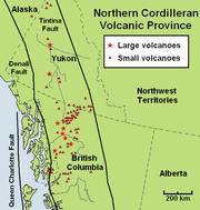
Northern Cordilleran volcanic province
The Northern Cordilleran Volcanic Province , formerly known as the Stikine Volcanic Belt, is a geologic province defined by the occurrence of Miocene to Holocene volcanoes in the Pacific Northwest of North America...
presents a record of volcanic activity in northwestern British Columbia
British Columbia
British Columbia is the westernmost of Canada's provinces and is known for its natural beauty, as reflected in its Latin motto, Splendor sine occasu . Its name was chosen by Queen Victoria in 1858...
, central Yukon
Yukon
Yukon is the westernmost and smallest of Canada's three federal territories. It was named after the Yukon River. The word Yukon means "Great River" in Gwich’in....
and the U.S. state
U.S. state
A U.S. state is any one of the 50 federated states of the United States of America that share sovereignty with the federal government. Because of this shared sovereignty, an American is a citizen both of the federal entity and of his or her state of domicile. Four states use the official title of...
of easternmost Alaska
Alaska
Alaska is the largest state in the United States by area. It is situated in the northwest extremity of the North American continent, with Canada to the east, the Arctic Ocean to the north, and the Pacific Ocean to the west and south, with Russia further west across the Bering Strait...
. The volcanic activity lies in the northern part of the Western Cordillera of the Pacific Northwest
Pacific Northwest
The Pacific Northwest is a region in northwestern North America, bounded by the Pacific Ocean to the west and, loosely, by the Rocky Mountains on the east. Definitions of the region vary and there is no commonly agreed upon boundary, even among Pacific Northwesterners. A common concept of the...
region of North America
North America
North America is a continent wholly within the Northern Hemisphere and almost wholly within the Western Hemisphere. It is also considered a northern subcontinent of the Americas...
. Extensional cracking
Rift
In geology, a rift or chasm is a place where the Earth's crust and lithosphere are being pulled apart and is an example of extensional tectonics....
of the North American Plate
North American Plate
The North American Plate is a tectonic plate covering most of North America, Greenland, Cuba, Bahamas, and parts of Siberia, Japan and Iceland. It extends eastward to the Mid-Atlantic Ridge and westward to the Chersky Range in eastern Siberia. The plate includes both continental and oceanic crust...
in this part of North America has existed for millions of years. Continuation of this continental rifting has fed scores of volcano
Volcano
2. Bedrock3. Conduit 4. Base5. Sill6. Dike7. Layers of ash emitted by the volcano8. Flank| 9. Layers of lava emitted by the volcano10. Throat11. Parasitic cone12. Lava flow13. Vent14. Crater15...
es throughout the Northern Cordilleran Volcanic Province over at least the past 20 million years (see Geology of the Pacific Northwest
Geology of the Pacific Northwest
The geology of the Pacific Northwest refers to the study of the composition , structure, physical properties and the processes that shape the Pacific Northwest region of the United States and Canada...
) and occasionally continued into geologically recent times.
Eruptive activity in the Northern Cordilleran Volcanic Province throughout its 20 million year history has been mainly the production of alkaline lava
Lava
Lava refers both to molten rock expelled by a volcano during an eruption and the resulting rock after solidification and cooling. This molten rock is formed in the interior of some planets, including Earth, and some of their satellites. When first erupted from a volcanic vent, lava is a liquid at...
s, including alkaline basalt
Basalt
Basalt is a common extrusive volcanic rock. It is usually grey to black and fine-grained due to rapid cooling of lava at the surface of a planet. It may be porphyritic containing larger crystals in a fine matrix, or vesicular, or frothy scoria. Unweathered basalt is black or grey...
s. A range of alkaline rock types not commonly found in the Western Cordillera are regionally widespread in the Northern Cordilleran Volcanic Province. These include nephelinite
Nephelinite
Nephelinite is a fine-grained or aphanitic igneous rock made up almost entirely of nepheline and clinopyroxene . If olivine is present, the rock may be classified as an olivine nephelinite. Nephelinite is dark in color and may resemble basalt in hand specimen...
, basanite
Basanite
Basanite is an igneous, volcanic rock with aphanitic to porphyritic texture.The mineral assembly is usually abundant feldspathoids , plagioclase, and augite, together with olivine and lesser iron-titanium oxides such as ilmenite and magnetite-ulvospinel; minor alkali feldspar may be present, as...
and peralkaline
Peralkaline
Peralkaline rocks include those igneous rocks which have a deficiency of aluminium such that sodium and potassium are in excess of that needed for feldspar. The presence of aegerine and riebeckite are indicative of peralkaline conditions....
phonolite
Phonolite
Phonolite is a rare igneous, volcanic rock of intermediate composition, with aphanitic to porphyritic texture....
, trachyte
Trachyte
Trachyte is an igneous volcanic rock with an aphanitic to porphyritic texture. The mineral assemblage consists of essential alkali feldspar; relatively minor plagioclase and quartz or a feldspathoid such as nepheline may also be present....
and comendite
Comendite
Comendite is a hard, peralkaline igneous rock, a type of light blue grey rhyolite. Phenocrysts are sodic sanidine with minor albite and bipyrimidal quartz. Comendite occurs in the mountains Tibrogargan, Coonowrin, Tunbubudla, Coochin, Saddleback, Tibberoowuccum and Ngungun in the Glass House...
lavas. The trachyte and comendite lavas are understood to have been created by fractionation of mainly alkali basalt magma in crustal reservoirs. An area of continental rifting, such as the Northern Cordilleran Volcanic Province, would aid the formation of high-level reservoirs of capable size and thermal activity to maintain long-lived fractionation.
In the past 15 million years, at least four large volcanoes have formed their way through dense igneous
Igneous rock
Igneous rock is one of the three main rock types, the others being sedimentary and metamorphic rock. Igneous rock is formed through the cooling and solidification of magma or lava...
and metamorphic
Metamorphic rock
Metamorphic rock is the transformation of an existing rock type, the protolith, in a process called metamorphism, which means "change in form". The protolith is subjected to heat and pressure causing profound physical and/or chemical change...
composed bedrock
Bedrock
In stratigraphy, bedrock is the native consolidated rock underlying the surface of a terrestrial planet, usually the Earth. Above the bedrock is usually an area of broken and weathered unconsolidated rock in the basal subsoil...
of this part of North America. This includes Hoodoo Mountain
Hoodoo Mountain
Hoodoo Mountain is a potentially active flat-topped stratovolcano in the Stikine Country of northwestern British Columbia, Canada, located northeast of Wrangell, Alaska on the north side of the lower Iskut River and east of its junction with the Stikine River...
, the Mount Edziza volcanic complex
Mount Edziza volcanic complex
The Mount Edziza volcanic complex is a large and potentially active north-south trending complex volcano in Stikine Country, northwestern British Columbia, Canada, located southeast of the small community of Telegraph Creek...
, the Level Mountain Range
Level Mountain Range
The Level Mountain Range, also known as Level Mountain, is a mountain range in Cassiar Country, northwestern British Columbia, Canada, located just northeast of Callison Ranch, southwest of Dease Lake and about north of Mount Edziza. It consists of a massive shield volcano and lies on the Nahlin...
and Heart Peaks
Heart Peaks
Heart Peaks, originally known as the Heart Mountains, is a mountain massif in the Northern Interior of British Columbia, Canada. It is located northwest of the small community of Telegraph Creek and just southwest of Callison Ranch. With a maximum elevation of , it rises above the surrounding...
, which are primarily located in northwestern British Columbia. Most notable of these is the 7.5 million year old Mount Edziza volcanic complex, which has had more than 20 eruptions in the past 10,000 years. The only activity present in the Northern Cordilleran Volcanic Province has been occasional earthquake
Earthquake
An earthquake is the result of a sudden release of energy in the Earth's crust that creates seismic waves. The seismicity, seismism or seismic activity of an area refers to the frequency, type and size of earthquakes experienced over a period of time...
s and constant boiling of hot spring
Hot spring
A hot spring is a spring that is produced by the emergence of geothermally heated groundwater from the Earth's crust. There are geothermal hot springs in many locations all over the crust of the earth.-Definitions:...
s. However, a high potential exists for renewed eruptive activity that could threaten life and property in the volcanic zone.
Production and rates in volcanism
More than 100 eruptions have occurred in the past 20 million years with a broad range of eruptive styles. These volcanic processes have created a range of different volcanic landforms, including stratovolcanoStratovolcano
A stratovolcano, also known as a composite volcano, is a tall, conical volcano built up by many layers of hardened lava, tephra, pumice, and volcanic ash. Unlike shield volcanoes, stratovolcanoes are characterized by a steep profile and periodic, explosive eruptions...
es, shield volcano
Shield volcano
A shield volcano is a type of volcano usually built almost entirely of fluid lava flows. They are named for their large size and low profile, resembling a warrior's shield. This is caused by the highly fluid lava they erupt, which travels farther than lava erupted from more explosive volcanoes...
es, lava dome
Lava dome
|250px|thumb|right|Image of the [[rhyolitic]] lava dome of [[Chaitén Volcano]] during its 2008–2009 eruption.In volcanology, a lava dome is a roughly circular mound-shaped protrusion resulting from the slow extrusion of viscous lava from a volcano...
s and cinder cones, along with a few isolated examples of rarer volcanic forms such as tuya
Tuya
A tuya is a type of distinctive, flat-topped, steep-sided volcano formed when lava erupts through a thick glacier or ice sheet. They are somewhat rare worldwide, being confined to regions which were covered by glaciers and also had active volcanism during the same time period.-Formation:Tuyas are...
s. Large persistent volcanoes of the Northern Cordilleran Volcanic Province can remain dormant for hundreds or thousands of years between eruptions and therefore the greatest risk caused by volcanic activity is not always readily apparent. Volcanics older than 14 million years are mainly found in the northern portion of the volcanic province while volcanics ranging from nine to four million years old exist only in the middle of the volcanic province. At least three types of volcanic zones are present in the Northern Cordilleran Volcanic Province, including large persistent lava plateaus like those found at the Mount Edziza volcanic complex, polygenetic volcanoes
Polygenetic volcanic field
A polygenetic volcanic field is a volcanic field of scattered volcanic vents. These volcanic fields, containing numerous polygenetic volcanoes, are noted for having more than one eruptive event from the same vent, rather than the more common monogenetic volcanic field. Polygenetic volcanic fields...
such as Hoodoo Mountain and monogenetic volcanoes
Monogenetic volcanic field
A monogenetic volcanic field is a volcanic field of small, scattered volcanic vents. These volcanic fields, containing numerous monogenetic volcanoes, are noted for having only one short eruptive event at each volcano, as opposed to regular volcanoes that have several eruptions from the same vent...
like the basaltic cinder cones found throughout the volcanic province. When Northern Cordilleran volcanoes do erupt, pyroclastic flow
Pyroclastic flow
A pyroclastic flow is a fast-moving current of superheated gas and rock , which reaches speeds moving away from a volcano of up to 700 km/h . The flows normally hug the ground and travel downhill, or spread laterally under gravity...
s, lava flows and landslide
Landslide
A landslide or landslip is a geological phenomenon which includes a wide range of ground movement, such as rockfalls, deep failure of slopes and shallow debris flows, which can occur in offshore, coastal and onshore environments...
s can devastate areas 10 km (6.2 mi) away and mudflow
Mudflow
A mudslide is the most rapid and fluid type of downhill mass wasting. It is a rapid movement of a large mass of mud formed from loose soil and water. Similar terms are mudflow, mud stream, debris flow A mudslide is the most rapid (up to 80 km/h, or 50 mph) and fluid type of downhill mass...
s of volcanic ash
Volcanic ash
Volcanic ash consists of small tephra, which are bits of pulverized rock and glass created by volcanic eruptions, less than in diameter. There are three mechanisms of volcanic ash formation: gas release under decompression causing magmatic eruptions; thermal contraction from chilling on contact...
and debris
Debris
Debris is rubble, wreckage, ruins, litter and discarded garbage/refuse/trash, scattered remains of something destroyed, or, in geology, large rock fragments left by a melting glacier etc. The singular form of debris is debris...
can inundate valleys 10 km (6.2 mi) downstream. Falling ash from explosive eruption
Explosive eruption
An explosive eruption is a volcanic term to describe a violent, explosive type of eruption. Mount St. Helens in 1980 was an example. Such an eruption is driven by gas accumulating under great pressure. Driven by hot rising magma, it interacts with ground water until the pressure increases to the...
s can disrupt human activities hundreds of kilometres downwind, and drifting clouds of fine volcanic ash can cause severe damage to jet aircraft
Jet aircraft
A jet aircraft is an aircraft propelled by jet engines. Jet aircraft generally fly much faster than propeller-powered aircraft and at higher altitudes – as high as . At these altitudes, jet engines achieve maximum efficiency over long distances. The engines in propeller-powered aircraft...
even hundreds of kilometres away. Volcanic deposits in the Northern Cordilleran Volcanic Province include lava flows, welded and unwelded pyroclastic deposits, hydroclastic deposits and other ice-contact volcanic deposits. The variety of different volcanic deposits is partly due to changes in eruption characteristics from mainly subaerial eruption
Subaerial eruption
A subaerial eruption is a volcanic eruption that has occurred on the surface. They generally produce pyroclastic flows, lava fountains, and lava flows, which are commonly classified in different subearial eruption types, including Plinian, Peléan, and Hawaiian eruptions. Subaerial eruptions...
s to broadly subglacial eruption
Subglacial eruption
A subglacial eruption is a volcanic eruption that has occurred under ice, or under a glacier. Subglacial eruptions can cause dangerous floods, lahars and create hyaloclastite and pillow lava. Subglacial eruptions sometimes form a subglacial volcano called a tuya. Tuyas in Iceland are called table...
s throughout the history of the Northern Cordilleran Volcanic Province.
Cascade Volcanoes
The Cascade Volcanoes are a number of volcanoes in a volcanic arc in western North America, extending from southwestern British Columbia through Washington and Oregon to Northern California, a distance of well over 700 mi ...
and Hawaiian
Hawaii (island)
The Island of Hawaii, also called the Big Island or Hawaii Island , is a volcanic island in the North Pacific Ocean...
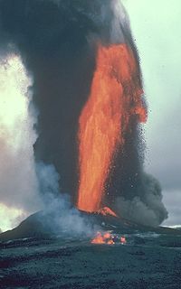
volcanism rates. However, geologists are aware the temporal volcanic patterns known for the Northern Cordilleran Volcanic Province should be looked at carefully because volcanics that pre-date the last glacial period have been eroded by glacial ice and many of the volcanics have not been directly dated or have not been dated in significant detail to identify more individual temporal patterns. Lava fountain
Lava fountain
A lava fountain is a volcanic phenomenon in which lava is forcefully but non-explosively ejected from a crater, vent, or fissure. Lava fountains may reach heights of up to . They may occur as a series of short pulses, or a continuous jet of lava. They are commonly seen in Hawaiian eruptions.-See...
s can occur in the Northern Cordilleran Volcanic Province roughly every 100 years.
Large basaltic shield volcanoes throughout the central Northern Cordilleran Volcanic Province form large lava plateaus and are the largest volcanoes of the volcanic zone. These extensive volcanoes are generally larger and more long-lived than volcanoes of adjacent volcanic zones, including the stratovolcanoes of the Cascade and Aleutian arcs. Mount Shasta
Mount Shasta
Mount Shasta is located at the southern end of the Cascade Range in Siskiyou County, California and at is the second highest peak in the Cascades and the fifth highest in California...
, the largest stratovolcano in the Cascade Arc and Mount Veniaminof
Mount Veniaminof
Mount Veniaminof is an active stratovolcano located on the Alaska Peninsula. The Alaska Volcano Observatory currently rates Veniaminof as Aviation Color Code GREEN and Volcano Alert Level NORMAL as of 15:36, 3 June 2009...
, one of the largest and most active volcanoes in the Aleutian Arc, have volumes of at least 350 km³ (84 cu mi), less than half of that of the Level Mountain and Edziza shield complexes. The massive Level Mountain Range shield, occupying an area of 1800 square kilometre and a volume of more than 860 km³ (206.3 cu mi), is the most voluminous and most long-lived volcano of the Northern Cordilleran Volcanic Province. Further south, the Mount Edziza volcanic complex resides as the seconed most voluminous volcano with an area of 1000 square kilometre and a volume of 670 km³ (160.7 cu mi). Just west of the Level Mountain Range lies Heart Peaks, the third most voluminous volcano of the Northern Cordilleran Volcanic Province with an area of 275 square kilometre. However, remains of a shield volcano that once covered an area of more than 900 square kilometre are present in the western Cassiar Mountains
Cassiar Mountains
The Cassiar Mountains are the most northerly group of the Northern Interior Mountains in the Canadian province of British Columbia and the Yukon Territory. They lie north and west of the Omineca Mountains, west of the northernmost Rockies and the Rocky Mountain Trench, north of the Hazelton...
as Maitland Volcano
Maitland Volcano
Maitland Volcano was a Pliocene age shield volcano in the western Cassiar Mountains of northwestern British Columbia, Canada. In the course of one million years, Maitland Volcano was formed on a mature, eroded Tertiary surface by rifting of the North American continent as thin alkali olivine basalt...
.
All of the known most recent eruptions have occurred in British Columbia, although there is evidence for volcanic activity in Yukon in the past thousand years. The two most recent were lava flow eruptions at Tseax Cone
Tseax Cone
The Tseax Cone , also called the Tseax River Cone or alternately the Aiyansh Volcano, is a young cinder cone and adjacent lava flows associated with the Nass Ranges and the Northern Cordilleran Volcanic Province...
in the 18th century and at The Volcano
The Volcano (British Columbia)
The Volcano, also known as Lava Fork volcano, is a small cinder cone in the Boundary Ranges of the Coast Mountains in northwestern British Columbia, Canada. It is located approximately northwest of the small community of Stewart near the head of Lava Fork...
in 1904. Reports of an eruption 80 km (49.7 mi) south of Gladys Lake in northern British Columbia were made by placer miners at the end of the 19th century, but no evidence for this eruption has been found, leading researchers to speculate the eruption as uncertain.
Volcanic activity begins
When the Mount Edziza volcanic complex began to form 7.5 million years ago, volcanism rates in the Northern Cordilleran Volcanic Province increased again. Early volcanic activity of the Mount Edziza volcanic complex seven million years ago constructed Armadillo Peak
Armadillo Peak
Armadillo Peak is a 7.5 million year old caldera, located about 3 km north of Bourgeaux Creek and northeast of Raspberry Pass, British Columbia, Canada. It is south of Mount Edziza and is overlapped by the Ice Peak central volcano, which was formed during the early Pleistocene. Its caldera is...
, the oldest and most central of the four central volcanoes comprising the complex. Its 2194 m (7,198.2 ft) summit is capped by 180 m (590.6 ft) thick fine-grained silica-rich trachyte lava flows that ponded inside the caldera
Caldera
A caldera is a cauldron-like volcanic feature usually formed by the collapse of land following a volcanic eruption, such as the one at Yellowstone National Park in the US. They are sometimes confused with volcanic craters...
to produce a lava lake
Lava lake
Lava lakes are large volumes of molten lava, usually basaltic, contained in a volcanic vent, crater, or broad depression. The term is used to describe both lava lakes that are wholly or partly molten and those that are solidified...
six million years ago during its final stage of activity. A massive stratovolcano was also formed on top of the Level Mountain Range shield volcano 7.1 to 5.3 million years ago during this increased period of volcanism when viscous peralkaline trachyte and comendite lavas were erupted. The stratovolcano has a volume of 860 km³ (206.3 cu mi) and comprises several volcanic vents, some of which were formally more than 2500 m (8,202.1 ft) in elevation. Glacial ice and streams have since dissected the stratovolcano into a series of valleys with intervening ridges that constitute the Level Mountain Range proper.
More Miocene age volcanics of and years are present at the Anderson
Anderson Bay
Anderson Bay is a bay of Atlin Lake in northwestern British Columbia, Canada, located southwest of Pike Bay.The landscape surrounding Anderson Bay lies in the Atlin Volcanic Field of the Northern Cordilleran Volcanic Province. During the Miocene period, a basaltic lava flow engulfed the southern...
and Moose bays of Atlin Lake
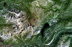
Atlin Lake
Atlin Lake is a lake in northwestern British Columbia and is that province's largest natural lake. The northern tip of the lake is in the Yukon, as is Little Atlin Lake. However, most of the lake lies within the Atlin District of British Columbia...
in northern British Columbia that represent remnants of columnar-jointed basalt lava flows. This indicates these volcanics are older than the Edziza and Level Mountain Range shields and they might represent the oldest volcanic events in the Northern Cordilleran Volcanic Province. However, their distinctive chemical characteristics and apparent large age differences compared to other volcanics in the Atlin area could also indicate that these columnar-jointed basalt lava flows are not part of the Northern Cordilleran Volcanic Province assemblage. In northern Yukon, similar aged volcanics can be found, including million year old volcanics at Forty Mile and million year old volcanics at Sixty Mile
Sixty Mile
Sixty Mile is the name of a mining property in western Yukon, Canada.At Sixty Mile, Miocene age volcanics are present. However, the type of volcanic landform these volcanics represent is unknown....
. However, the type of volcanic landforms these volcanics represent are unknown.
Volcanism 5.3 to 1.6 million years ago
In northern British Columbia, remnants of a shield volcano are found throughout the western Cassiar Mountains. This prehistoric shield volcano, known as Maitland VolcanoMaitland Volcano
Maitland Volcano was a Pliocene age shield volcano in the western Cassiar Mountains of northwestern British Columbia, Canada. In the course of one million years, Maitland Volcano was formed on a mature, eroded Tertiary surface by rifting of the North American continent as thin alkali olivine basalt...
, was erupted from five to four million years ago on a mature eroded surface as thin hawaiite and basaltic lava flows engulfed the surrounding landscape. Remnants of this prehistoric shield volcano include a cluster of 14 volcanic plugs and scattered cliff-bounded basaltic lava flows.
At the southern end of the Mount Edziza volcanic complex, volcanism constructed the Spectrum Range
Spectrum Range
The Spectrum Range, formerly called the Spectrum Mountains and the Rainbow Mountains, is a subrange of the Tahltan Highland in the Stikine Country of northwestern British Columbia, 20 km west of the Stewart-Cassiar Highway, south of Mount Edziza and north of the Arctic Lake Plateau. The...
three to 2.5 million years ago. Named for its extensive colouration, this nearly circular lava dome is up to 650 m (2,132.5 ft) thick and more than 10 km (6.2 mi) wide with a basaltic shield volcano forming its broad base. Since its formation, the Spectrum Range lava dome has been deeply cut by erosion, forming an extensive valley system. This valley system exposes large comendite and trachyte lava flows of the dome, including faults of a hidden 4.5 km (2.8 mi) wide caldera.
A series of lava domes were constructed in the Level Mountain Range alpine valley system 4.5 to 2.5 million years ago. These domes intrude the glacially eroded core of the 860 km³ (206.3 cu mi) stratovolcano and headward erosion has further modified the Level Mountain Range shield by incising youthful V-shaped stream canyons into the lava plateau margin.
Volcanism 1.6 million to 10,000 years ago
Throughout the PleistocenePleistocene
The Pleistocene is the epoch from 2,588,000 to 11,700 years BP that spans the world's recent period of repeated glaciations. The name pleistocene is derived from the Greek and ....
epoch 1.6 million to 10,000 years ago, volcanism in the Northern Cordilleran Volcanic Province was broadly associated with glacial ice and ice sheets during glacial periods, including the large Cordilleran Ice Sheet
Cordilleran Ice Sheet
The Cordilleran ice sheet was a major ice sheet that covered, during glacial periods of the Quaternary, a large area of North America. This included the following areas:*Western Montana*The Idaho Panhandle...
. This volcano-ice association can be recognized in three different physiographic settings, each displaying unique relationships between topography, volcanism and glacial ice. The first volcano-ice interaction is displayed as tuyas, including Tuya Butte
Tuya Butte
Tuya Butte is a tuya in the Tuya Range of north-central British Columbia, Canada. It is a bit less isolated from other ranges than neighbouring Mount Josephine...
, on the Tanzilla Plateau
Tanzilla Plateau
The Tanzilla Plateau is a plateau in the Stikine Country of the Northern Interior of British Columbia, Canada. It is a sub-plateau of the Stikine Plateau and is located east of the Tuya River, north of the Stikine River and surrounding Dease Lake; its eastern extremity verges on the Stikine Ranges...
in the Northern Interior of British Columbia
British Columbia Interior
The British Columbia Interior or BC Interior or Interior of British Columbia, usually referred to only as the Interior, is one of the three main regions of the Canadian province of British Columbia, the other two being the Lower Mainland, which comprises the overlapping areas of Greater Vancouver...
. This sub-section of the Stikine Plateau
Stikine Plateau
The Stikine Plateau is a plateau in northern British Columbia, Canada. It lies between the Boundary Ranges of the Coast Mountains on the west and southwest and the Cassiar Mountains along its northeast, and between the Skeena Mountains on its south and southeast and the Jennings and Nakina Rivers...
consists of large flatlands with hills of low relief, and might have been one of the areas of ice accumulation for the Cordilleran Ice Sheet. Tanzilla Plateau volcanism throughout the Pleistocene epoch was basaltic subglacial eruption
Subglacial eruption
A subglacial eruption is a volcanic eruption that has occurred under ice, or under a glacier. Subglacial eruptions can cause dangerous floods, lahars and create hyaloclastite and pillow lava. Subglacial eruptions sometimes form a subglacial volcano called a tuya. Tuyas in Iceland are called table...
s. The most generally known subglacial volcano
Subglacial volcano
A subglacial volcano, also known as a glaciovolcano, is a volcanic form produced by subglacial eruptions or eruptions beneath the surface of a glacier or ice sheet which is then melted into a lake by the rising lava...
es are distinctive tuyas, which commonly reach more than 100 m (328.1 ft) in elevation. Other volcanic forms also exist, some of which are basic and others that are probably the products of weathering. The subdued relief on the Tanzilla Plateau strongly influenced edifice morphologies, favoring broad-based tuyas. The hydrological conditions in these areas likely were controlled by relatively uniform ice thickness and gentle topography.
The seconed type of volcano-ice interaction is located only to the east, south and southwest of the Tanzilla Plateau, in the Cassiar Mountains, Skeena Mountains
Skeena Mountains
The Skeena Mountains, also known as the Skeenas, are a subrange of the Interior Mountains of northern British Columbia, Canada, essentially flanking the upper basin of the Skeena River. They lie just inland from the southern end of the Boundary Ranges of the Coast Mountains, and also of the...
and in the Boundary Ranges. Volcanic activity in these locations is also largely mafic in composition, but the extensive elevations of these areas had a much more impressive influence on glaciation and subglacial volcanism. High altitude glaciation took over when the Cordilleran Ice Sheet was not present and even when buried by the Cordilleran Ice Sheet, basal ice movement was strongly influenced by the deep, pre-glacial drainages. Accordingly, the erosional remnants of subglacial volcanoes are minor and intermittent. In the Skeena Mountains, separated outcrops of pillow lava and volcanic breccia are generally found side by side on the summits of sharp rugged mountain ridges, with presumably temporally-associated pyroclastic rocks having collected downslope.
The third type of volcano-ice interaction is geographically restricted to three volcanoes, including the Level Mountain Range, the Mount Edziza volcanic complex and Hoodoo Mountain. All three volcanoes are broad enough to hold ice caps that likely altered regional ice flow while still being altered by the Cordilleran Ice Sheet at individual periods. The Mount Edziza and Level Mountain Range complexes have shelves of older lava with elevations more than 1 km (0.621372736649807 mi) and have been zones of volcanic activity long enough that their geothermal activities might have had effects on movements of the Cordilleran Ice Sheet much like the Grímsvötn
Grímsvötn
The Grímsvötn sub-glacial lakes and the volcano of the same name are in South-East Iceland. They are in the highlands of Iceland at the northwestern side of the Vatnajökull ice-cap. The lakes are at , at an elevation of...
caldera in Iceland, which has been a significant heat source beneath the vast Vatnajökull
Vatnajökull
Vatnajökull is the largest glacier in Iceland. It is located in the south-east of the island, covering more than 8% of the country.-Size:With an area of 8,100 km², Vatnajökull is the largest ice cap in Europe by volume and the second largest in area Vatnajökull is the largest glacier in...
icecap. At the Edziza complex, most of the subglacial products were formed on top of the main lava plateau, which now rises at least 1000 m (3,280.8 ft) in elevation above adjacent stream valleys. The Edziza complex consists of a collection of mafic subglacial products, but more unusually, including Hoodoo Mountain and Level Mountain, comprises some of the largest deposits of peralkaline felsic subglacial volcanics known. At the Edziza and Level Mountain Range complexes, glacier hydrology of the Cordilleran Ice Sheet was possibly dominated by a complicated interaction between drainage on the flat plateaus under relatively thinner ice and drainage within nearby steep valleys filled with much thicker ice.
Heart Peaks
Heart Peaks, originally known as the Heart Mountains, is a mountain massif in the Northern Interior of British Columbia, Canada. It is located northwest of the small community of Telegraph Creek and just southwest of Callison Ranch. With a maximum elevation of , it rises above the surrounding...
shield volcano rises with a topographic prominence
Topographic prominence
In topography, prominence, also known as autonomous height, relative height, shoulder drop , or prime factor , categorizes the height of the mountain's or hill's summit by the elevation between it and the lowest contour line encircling it and no higher summit...
of 1025 m (3,362.9 ft) above the Nahlin Plateau
Nahlin Plateau
The Nahlin Plateau is a plateau in northwestern British Columbia, Canada, located between the Sheslay River and Tuya River on the west and east and the Nahlin River and the Stikine River to the north and south...
with rhyolitic lava domes capping its summit. Heart Peaks is made of flat-lying basaltic and trachybasaltic lava flows and pyroclastic rocks. The most recent eruption at the shield is of dominantly Pleistocene age and late-stage Holocene activity is uncertain.
On the divide between the head of the Omineca
Omineca River
Omineca River is a river in northern British Columbia, Canada. It flows into the Williston Lake, and is part of the Peace River basin. It was originally a tributary of the Finlay River before the creation of Lake Williston.-References:...
and Bear
Bear River (Sustut River)
The Bear River is a river in northwestern British Columbia, Canada. It flows northwest into the Sustut River, which flows southwest into the upper Skeena River....
rivers, The Thumb
The Thumb (Omineca)
The Thumb is a mountain located south of Sitchiada Mountain on the east side of Bear Lake, on the divide between the upper Omineca River and the basin of the Bear River in the Omineca Country of the Central-North Interior of British Columbia, Canada...
rises with a topographic prominence
Topographic prominence
In topography, prominence, also known as autonomous height, relative height, shoulder drop , or prime factor , categorizes the height of the mountain's or hill's summit by the elevation between it and the lowest contour line encircling it and no higher summit...
of 180 m (590.6 ft) above gently sloping benchland near the crest of the Connelly Range
Connelly Range
The Connelly Range is a subrange of the Hogem Ranges of the Omineca Mountains, located between Bear Lake and the headwaters of the Omineca River in northern British Columbia, Canada. As the Omineca is in the Arctic Ocean drainage and Bear Lake that of the Pacific, the range is part of the...
. It is the largest among a cluster of seven steep-sided volcanic plugs associated with dikes, lava flows and remnants of cinder cones.
Ne Ch'e Ddhawa
Ne Ch'e Ddhawa
Ne Ch'e Ddhawa is a cinder cone, located 7 km upstream from Fort Selkirk in the Fort Selkirk Volcanic Field, Yukon, Canada. The volcano erupted subglacially during the late Pleistocene, erupting hyaloclastite tuffs, breccias, and pillow breccias.-See also:*Volcanism of Canada*List of Northern...
, an extinct volcano in the Fort Selkirk Volcanic Field of central Yukon, reaches a height of 300 m (984.3 ft) near the junction of the Pelly
Pelly River
The Pelly River is a river in Canada, and is a headstream of the Yukon River. The river originates west of the Mackenzie Mountains and flows 530 km long through the south central Yukon. The Pelly has two main tributaries, the Ross and Macmillan rivers.The river was named by Robert Campbell in...
and Yukon
Yukon River
The Yukon River is a major watercourse of northwestern North America. The source of the river is located in British Columbia, Canada. The next portion lies in, and gives its name to Yukon Territory. The lower half of the river lies in the U.S. state of Alaska. The river is long and empties into...
rivers. It was erupted subglacially under the Cordilleran Ice Sheet between 0.8 and one million years ago, depositing hyaloclastite
Hyaloclastite
Hyaloclastite is a hydrated tuff-like breccia rich in black volcanic glass, formed during volcanic eruptions under water, under ice or where subaerial flows reach the sea or other bodies of water. It has the appearance of angular flat fragments sized between a millimeter to few centimeters...
tuff
Tuff
Tuff is a type of rock consisting of consolidated volcanic ash ejected from vents during a volcanic eruption. Tuff is sometimes called tufa, particularly when used as construction material, although tufa also refers to a quite different rock. Rock that contains greater than 50% tuff is considered...
s, breccias and pillow breccias that now form the volcano.
In the Boundary Ranges of northwestern British Columbia, Hoodoo Mountain began its formation at least 100,000 years ago mostly under glacial ice of the Cordilleran Ice Sheet. More than 90% of Hoodoo Mountain was formed during this eruptive period and interlayed peralkaline phonolitic and trachytic lava flows and hyaloclastites are the main volcanics comprising the volcano. On the northern flank of Hoodoo Mountain lies the smaller Little Bear Mountain
Little Bear Mountain
Little Bear Mountain is a basaltic Pleistocene age tuya in the Boundary Ranges of the Coast Mountains that adjoins Hoodoo Mountain to the north. Little Bear Mountain is part of the Northern Cordilleran Volcanic Province.-See also:* List of volcanoes in Canada...
, a tuya which also formed in the Pleistocene epoch.
Ice Peak
Ice Peak
Ice Peak is a stratovolcano, located west of Tatogga and south of Mount Edziza, British Columbia, Canada. It overlaps the 7.5 million year old Armadillo Peak. It lies on a large volcanic plateau, which is made of basaltic lava flows from the massive Mount Edziza volcanic complex...
, which overlaps the northern flank of Armadillo Peak, began to form when the regional Cordilleran Ice Sheet began retreating from the Mount Edziza volcanic complex 1,600,000 years ago. It is a stratovolcano that was constructed when large areas of the Edziza lava plateau were free from glacial ice, but additional parts of the Mount Edziza volcanic complex were likely still covered by glacial ice. Volcanic activity at Ice Peak during this period produced lava flows and pyroclastic rocks, which mixed with meltwater
Meltwater
Meltwater is the water released by the melting of snow or ice, including glacial ice and ice shelfs over oceans. Meltwater is often found in the ablation zone of glaciers, where the rate of snow cover is reducing...
to produce debris flow
Debris flow
A debris flow is a fast moving, liquefied landslide of unconsolidated, saturated debris that looks like flowing concrete. It is differentiated from a mudflow in terms of the viscosity and textural properties of the flow. Flows can carry material ranging in size from clay to boulders, and may...
s. As Ice Peak began to form, basic lava spread to the flanks of Ice Peak where it formed meltwater lakes and combines with and forms part of the adjacent shield volcano. Mount Edziza
Mount Edziza
Mount Edziza is a stratovolcano in the Stikine Country of northwestern British Columbia, Canada. The volcano and the surrounding area are protected within Mount Edziza Provincial Park. It consists of a complex of multiple peaks and ridges, with several glaciers flowing in all directions. The summit...
, a steep-sided stratovolcano overlapping the northern flank of Ice Peak and the most northerly of the four central volcanoes comprising the Mount Edziza volcanic complex, began to form a million years ago when the Cordilleran Ice Sheet retreated from the upper flanks of the Edziza lava plateau. Its smooth northern and western flanks are only slightly channeled by erosion and they curve up to a circular 2700 m (8,858.3 ft) summit ridge which surrounds a central ice-filled caldera 2 km (1.2 mi) in diameter. Active cirque
Cirque
Cirque may refer to:* Cirque, a geological formation* Makhtesh, an erosional landform found in the Negev desert of Israel and Sinai of Egypt*Cirque , an album by Biosphere* Cirque Corporation, a company that makes touchpads...
s on Edziza's eastern flank have breached the caldera rim, exposing the remnants of several lava lakes that ponded in the caldera 900,000 years ago. As well, subglacial eruptions around the flanks of Mount Edziza and Ice Peak constructed piles of pillow lava and hyaloclastite.
Prindle Volcano, the northernmost volcano of the Northern Cordilleran Volcanic Province and one of the most isolated volcanoes in Alaska, was formed on the Yukon-Tanana upland during the Pleistocene epoch. It is a small cinder cone made of basanite with a 90 m (295.3 ft) deep breached volcanic crater at its summit. Extending from Prindle's breached volcanic crater is a 11.2 km (7 mi) long basanite lava flow that flowed southeast of the cone then flowed southwest into a river valley.
The Cassiar Mountains and Tanzilla Plateau in northern British Columbia are dominated by tuyas of the broad Tuya Volcanic Field
Tuya Volcanic Field
The Tuya volcanic field is a volcanic field of tuyas located in far northern British Columbia, Canada, near the border with the Yukon Territory and focussed on the area of the Tuya Range, a subrange of the Stikine Ranges of the Cassiar Mountains, though some vents are in the Kawdy Plateau, the...
. These flat-topped, steep-sided subglacial volcanoes were formed when magma intruded into and melted a vertical pipe in the overlying Cordilleran Ice Sheet. At least six volcanoes formed beneath glacial ice close to Tuya Lake
Tuya Lake
Tuya Lake, located in northwestern British Columbia, Canada, presumably derives its name from the presence of nearby steep-sided, flat-topped volcanoes, known as tuyas...
, including Ash Mountain
Ash Mountain (British Columbia)
Ash Mountain is the highest summit in the Tuya Range of the Stikine Ranges in northcentral British Columbia, Canada, located immediately north of High Tuya Lake at the north end of Tuya Mountains Provincial Park. It is one of the six tuyas clustered close to Tuya Lake...
, South Tuya
South Tuya
South Tuya, also called Southern Tuya, is a tuya clustered around Tuya Lake in the Northern Cordilleran Volcanic Province in British Columbia, Canada...
, Tuya Butte
Tuya Butte
Tuya Butte is a tuya in the Tuya Range of north-central British Columbia, Canada. It is a bit less isolated from other ranges than neighbouring Mount Josephine...
, Mathews Tuya
Mathews Tuya
Mathews Tuya is a subglacial mound in northcentral British Columbia. It is one of the six tuyas close to Tuya Lake. It has been partly glaciated so it is probably older than 10,000 years. The other volcanoes in the area include Tuya Butte, South Tuya and Ash Mountain...
. Ash Mountain at the head of Parallel Creek
Parallel Creek
Parallel Creek is a creek in northern British Columbia, Canada. It flows northwest into an expansion of the Jennings River....
consists of pillow lava and hyaloclastite, South Tuya consists of loose volcanic debris with basaltic dikes intruding into the volcano and Tuya Butte and Mathews Tuya consist of pillow lava and hyaloclastite on its lower flanks with subaerially erupted lava flows at their flat-topped summits.
Volcanism in the past 10,000 years
Numerous eruptions have occurred since the beginning of the HoloceneHolocene
The Holocene is a geological epoch which began at the end of the Pleistocene and continues to the present. The Holocene is part of the Quaternary period. Its name comes from the Greek words and , meaning "entirely recent"...
epoch 10,000 years ago, when the vast Cordilleran Ice Sheet retreated rapidly at the end of the last glacial period. The majority of volcanic eruptions throughout the Holocene have occurred in British Columbia while fewer Holocene eruptions have occurred in Yukon.
In the early Holocene epoch, volcanism at Hoodoo Mountain produced lava flows with well-preserved lava channel
Lava channel
A lava channel is a stream of fluid lava contained within marginal zones of static lava or levees. The initial channel may not contain levees per se, until the parental flow solidifies over what develops into the channel and creates simple levees. This initial levee allows for the building of a...
s on its northwestern and southwestern flanks and are largely unglaciated, suggesting the last eruptive activity at Hoodoo Mountain occurred in an ice-free environment. These lava flows originated from the mountain's flat-topped summit and volcanic vents on its flanks. Geologists do not always agree on the dates of these more recent eruptions, some dating them to nice thousand years ago, others to as recently as seven thousand years ago.
Alaska Panhandle
Southeast Alaska, sometimes referred to as the Alaska Panhandle, is the southeastern portion of the U.S. state of Alaska, which lies west of the northern half of the Canadian province of British Columbia. The majority of Southeast Alaska's area is part of the Tongass National Forest, the United...
, lava flows and eight small volcanoes form a volcanic field known as the Iskut-Unuk River Cones
Iskut-Unuk River Cones
The Iskut-Unuk River Cones are a group of eight small basaltic centres at the southern end of the Northern Cordilleran Volcanic Province in the Boundary Ranges of the Coast Mountains. The lava flows date back 70,000 years, but the subaerial vents produced cinder cones and lava flows that were...
. Lava flows date back 70,000 years ago during the Pleistocene epoch, but the eight volcanoes were likely formed between nine thousand and a few hundred years ago. At least five volcanoes sent lava 20 km (12.4 mi) down the Iskut and Unuk River valleys and their tributaries. The other three volcanoes were formed when glacial ice existed adjacent to the associated volcanic vents, creating scoria, pillow lava and hyaloclastite breccia. Volcanism in the Iskut River area has created at least ten lava flows and Lava Fork at least three. The most recent eruption of the Iskut-Unuk River Cones at The Volcano (also called Lava Fork volcano) in 1904 is also the most recent volcanic eruption in Canada.
Immediately north of the junction of the Pelly and Yukon rivers, Volcano Mountain
Volcano Mountain
Volcano Mountain is an active cinder cone in central Yukon Territory, Canada, located a short distance north of Fort Selkirk, near the confluence of the Pelly and Yukon Rivers...
in central Yukon consists of a cinder cone and a series of lava flows. It is the youngest volcano in the Fort Selkirk Volcanic Field and lava flows originated from fractures in the volcano's flank. These lava flows extend northeast and southwest of the volcano. The northeastern lava flow extends 5.5 km (3.4 mi) from Volcano Mountain whereas the southwestern lava flow extends 3 km (1.9 mi) from the volcano. These lava flows are composed of olivine nephelinite, a type of lava not commonly found on Earth. Nephelinite lavas are usually interpreted to have originated much deeper in the Earth's mantle unlike the typical basaltic lava found throughout the Northern Cordilleran Volcanic Province. The nephelinite lava flows at Volcano Mountain remain clear from vegetation and seem to be only a few hundred years old. However, dating of sediments in a lake dammed by the nephelinite lavas suggest the lava flows could not be younger than mid-Holocene and could be early Holocene or older. Therefore, the exact age for the most recent eruptions at Volcano Mountain are unknown.

Tseax River
The Tseax River, also known as Ksi Sii Aks in the Nisga'a language, is a tributary of the Nass River in northwestern British Columbia, Canada. It is most notable as the namesake of Tseax Cone, a volcano within its basin that was responsible for an eruption that killed 2,000 Nisga'a people. Prior...
. It is a young Holocene age cinder cone that was the source for a major basalt lava flow eruption around the years 1750 and 1775 that travelled into the Tseax River, damming it and forming Lava Lake
Lava Lake
Lava Lake is a lava dammed lake located in northwestern British Columbia, Canada. The lake lies within the Nisga'a Memorial Lava Beds Provincial Park, which includes fishing, hiking and other features.-Formation:...
. The lava flow subsequently travelled 11 km (6.8 mi) north to the Nass River
Nass River
The Nass River is a river in northern British Columbia, Canada. It flows from the Coast Mountains southwest to Nass Bay, a sidewater of Portland Inlet, which connects to the North Pacific Ocean via the Dixon Entrance...
, where it filled the flat valley floor for an additional 10 km (6.2 mi), making the entire lava flow 22.5 km (14 mi) long. Native legends from Nisga'a
Nisga'a
The Nisga’a , often formerly spelled Nishga and spelled in the Nisga’a language as Nisga’a, are an Indigenous nation or First Nation in Canada. They live in the Nass River valley of northwestern British Columbia. Their name comes from a combination of two Nisga’a words: Nisk’-"top lip" and...
people in the area tell of a prolonged period of disruption by the volcano, including the destruction of two Nisga'a villages known as Lax Ksiluux
Lax Ksiluux, British Columbia
Lax Ksiluux is the name of a former First Nations community in northwestern British Columbia, Canada. It existed on the south side of the Nass River near a creek known as Ts'oohl Ts'ap....
and Wii Lax K'abit. Nisga'a people dug pits for shelter but at least 2,000 Nisga'a people were killed due to volcanic gas
Volcanic gas
|250px|thumb|right|Image of the [[rhyolitic]] [[lava dome]] of [[Chaitén Volcano]] during its 2008-2010 eruption.Volcanic gases include a variety of substances given off by active volcanoes...
es and poisonous smoke (most likely carbon dioxide
Carbon dioxide
Carbon dioxide is a naturally occurring chemical compound composed of two oxygen atoms covalently bonded to a single carbon atom...
). This is Canada's worst known geophysical disaster and is the only eruption in Canada for which legends of First Nations
First Nations
First Nations is a term that collectively refers to various Aboriginal peoples in Canada who are neither Inuit nor Métis. There are currently over 630 recognised First Nations governments or bands spread across Canada, roughly half of which are in the provinces of Ontario and British Columbia. The...
people have been proven true. As of 1993, the Tseax Cone quietly rests in Nisga'a Memorial Lava Beds Provincial Park
Nisga'a Memorial Lava Beds Provincial Park
Nisga'a Memorial Lava Bed Provincial Park is a provincial park in the Nass River valley in northwestern British Columbia, Canada, about 80 kilometres north of Terrace, and near the Nisga'a Villages of Gitlakdamix and Gitwinksihlkw.The park was established by Order in Council on April 29, 1992,...
.
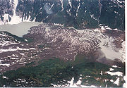
More than 20 eruptions have occurred at the Mount Edziza volcanic complex in the past 10,000 years, including Mess Lake Cone
Mess Lake Cone
Mess Lake Cone is a cinder cone in northwestern British Columbia, Canada. It is polygenetic in nature, having erupted more than once throughout its eruptive history. Mess Lake Cone is one of the volcanoes that produced young basaltic lava flows in the central portion of the Mount Edziza volcanic...
, Kana Cone
Kana Cone
Kana Cone is a red nested cinder cone in northern British Columbia, Canada, located northeast of Eve Cone in Mount Edziza Provincial Park.-See also:*List of volcanoes in Canada*List of Northern Cordilleran volcanoes*Volcanism of Canada...
, Cinder Cliff
Cinder Cliff
Cinder Cliff is a cinder cone in northern British Columbia, Canada. It is thought to have last erupted during the Holocene period and is part of the Mount Edziza volcanic complex.-See also:*List of volcanoes in Canada*List of Northern Cordilleran volcanoes...
, Icefall Cone
Icefall Cone
Icefall Cone is a cinder cone in northern British Columbia, Canada. It is thought to have last erupted during the Holocene period and forms part of the Mount Edziza volcanic complex.-See also:*List of volcanoes in Canada...
, Ridge Cone
Ridge Cone
Ridge Cone is a cinder cone in northern British Columbia, Canada. It is thought to have last erupted in the Holocene period and is part of the Mount Edziza volcanic complex.-See also:*List of volcanoes in Canada*List of Northern Cordilleran volcanoes...
, Williams Cone
Williams Cone
Williams Cone is a satellite cone of Mount Edziza, located 36 kilometers east of Telegraph Creek. It lies just off the northern edge of the Tencho Icefield and is one of the many postglacial cinder cones that lie on the Mount Edziza volcanic complex...
, Walkout Creek Cone
Walkout Creek Cone
Walkout Creek Cone is a cinder cone in northwestern British Columbia, Canada. It is one of the volcanoes that produced young basaltic lava flows in the central portion of the Mount Edziza volcanic complex in the past 10,000 years...
, Moraine Cone
Moraine Cone
Moraine Cone is a cinder cone in northern British Columbia, Canada. It is thought to have last erupted in the Holocene period and is part of the Mount Edziza volcanic complex.-See also:*List of volcanoes in Canada*List of Northern Cordilleran volcanoes...
, Sidas Cone
Sidas Cone
Sidas Cone is one of the cinder cones located north on the Mount Edziza plateau in British Columbia, Canada. Sidas Cone is visible from almost anywhere around the plateau.-See also:* Northern Cordilleran Volcanic Province* Volcanism of Canada...
, Sleet Cone
Sleet Cone
Sleet Cone is a cinder cone in northern British Columbia, Canada. It lies in the Desolation Lava Field and is thought to have last erupted in the Holocene period and is part of the Mount Edziza volcanic complex.-See also:*List of volcanoes in Canada...
, Storm Cone
Storm Cone
Storm Cone is a cinder cone in northern British Columbia, Canada. It is thought to have last erupted in the Holocene period and lies on the Desolation lava field which is part of the Mount Edziza volcanic complex.-See also:*List of volcanoes in Canada...
, Triplex Cone
Triplex Cone
Triplex Cone is a cinder cone in northern British Columbia, Canada. It is thought to have last erupted in the Holocene period.-See also:*List of volcanoes in Canada*List of Northern Cordilleran volcanoes*Volcanism of Canada*Volcanism of Western Canada...
, Twin Cone
Twin Cone
Twin Cone is a cinder cone in northern British Columbia, Canada. It is thought to have last erupted in the Holocene period.-See also:*List of volcanoes in Canada*List of Northern Cordilleran volcanoes*Volcanism of Canada*Volcanism of Western Canada...
, Cache Hill
Cache Hill
Cache Hill is a cinder cone in northern British Columbia, Canada. It is thought to have last erupted in the Holocene period. Once used as an airdrop for food and supplies by the Geophysical Survey of Canada, hence its name, it is located north of Raspberry Pass in Mount Edziza Provincial Park.-See...
, Camp Hill
Camp Hill (British Columbia)
Camp Hill is a cinder cone in northern British Columbia, Canada. It is thought to have last erupted in the Holocene period.-See also:*List of volcanoes in Canada*List of Northern Cordilleran volcanoes*Volcanism of Canada*Volcanism of Western Canada...
, Cocoa Crater, Coffee Crater
Coffee Crater
Coffee Crater is a well-preserved cinder cone south of Mount Edziza, British Columbia, Canada. It was formed during the Holocene period. It is within the Snowshoe lava field which in turn form part of the Mount Edziza volcanic complex.-See also:...
, Nahta Cone
Nahta Cone
Nahta Cone is a cinder cone in northern British Columbia, Canada, located southwest of Tatogga, north of Wetalth Ridge and south of Telegraph Creek...
, Tennena Cone
Tennena Cone
Tennena Cone is a subglacial mound in northern British Columbia, Canada, located just southwest of Mount Edziza in Mount Edziza Provincial Park.-See also:*List of volcanoes in Canada*List of Northern Cordilleran volcanoes*Volcanism of Canada...
, The Saucer
The Saucer
The Saucer is a cinder cone in northern British Columbia, Canada. It is thought to have last erupted in the Holocene epoch.-See also:*List of volcanoes in Canada*List of Northern Cordilleran volcanoes*Volcanism of Canada*Volcanism of Western Canada...
and the well-preserved Eve Cone
Eve Cone
Eve Cone is a well-preserved black cinder cone on the Big Raven Plateau, British Columbia, Canada. It is one of the 30 cinder cones on the flanks of the massive shield volcano of Mount Edziza that formed in the year 700, making it one of the most recent eruptions on the Big Raven Plateau and in...
. These cinder cones were formed no more than the year 700 based on the age of burnt plant stems still rooted in former soil under 2 m (6.6 ft) of loose basaltic fragments. The cones were built on the basaltic fragments and blocky lava fields surrounding the cones. The Snowshoe Lava Field
Snowshoe lava field
The Snowshoe Lava Field is a volcanic field associated with the Mount Edziza volcanic complex in northern British Columbia, Canada. It is on the southern end of the Big Raven Plateau and is an area of young lava flows.-Volcanoes:...
on the southern end of the Big Raven Plateau
Big Raven Plateau
The Big Raven Plateau is a lava plateau in northern British Columbia, Canada, located west of Mount Edziza in Mount Edziza Provincial Park and Recreation Area...
is one of the areas of young lava flows in the region while the Desolation Lava Field
Desolation Lava Field
The Desolation Lava Field is a volcanic field associated with the Mount Edziza volcanic complex in British Columbia, Canada. It covers on the northern end of the Mount Edziza volcanic complex and is the largest area of the youngest lava flows. The longest lava flow from the field and the volcanic...
on the northern end of the Big Raven Plateau is the largest area of young lava flows, covering an area of 150 square kilometre. The longest lava flow is 12 km (7.5 mi). This volcanic activity was followed by at least two younger, but still undated eruptions.
Xenolith
A xenolith is a rock fragment which becomes enveloped in a larger rock during the latter's development and hardening. In geology, the term xenolith is almost exclusively used to describe inclusions in igneous rock during magma emplacement and eruption...
s composed of granite and megacrysts of olivine, pyroxene and spinel.
An eruption was reported in the Atlin Volcanic Field
Atlin Volcanic Field
The Atlin Volcanic Field, also called the Llangorse Volcanic Field and the Surprise Lake Volcanic Field, is a group of late-Pleistocene to Holocene cinder cones that lies on the Teslin Plateau east of Atlin Lake, Canada. The largest volcanic feature is the 1880-m-high Ruby Mountain which has been...
by placer miners
Placer mining
Placer mining is the mining of alluvial deposits for minerals. This may be done by open-pit or by various surface excavating equipment or tunneling equipment....
on November 8, 1898. Miners working in the area reportedly were able to work during the dark nights due to the glow of the eruption. A news report published on December 1, 1898 by the American newspaper publisher The New York Times
The New York Times
The New York Times is an American daily newspaper founded and continuously published in New York City since 1851. The New York Times has won 106 Pulitzer Prizes, the most of any news organization...
stated:
In 1898 the Atlin
Atlin, British Columbia
Atlin is a community in northwestern British Columbia, Canada, located on the eastern shore of Atlin Lake. In addition to continued gold-mining activity, Atlin is a tourist destination for fishing, hiking and Heliskiing. As of 2004, there are 450 permanent residents.The name comes from Áa Tlein,...
area was in dispute with the Alaska-British Columbia boundary
Alaska Boundary Dispute
The Alaska boundary dispute was a territorial dispute between the United States and Canada . It was resolved by arbitration in 1903. The dispute had been going on between the Russian and British Empires since 1821, and was inherited by the United States as a consequence of the Alaska Purchase in...
, leading American news broadcasters stating the Atlin area was in Alaska rather than in northwestern British Columbia. This Alaska-British Columbia boundary dispute was eventually resolved by arbitration in 1903 and no evidence for the 1898 eruption has been found, leading researchers to speculate the eruption and report as uncertain. However, given the location of the placer operations from which the eruption was supposedly visible (Pine, Birch, Discovery, and McKee creeks) and the reported location of the volcano 80 km (49.7 mi) south of Gladys Lake, the vent might possibly be in the very rugged and inaccessible Coast Mountains south or southwest of Atlin Lake.
On the south side of the Khutzeymateen Inlet
Khutzeymateen Inlet
Khutzeymateen Inlet is one of the lesser principal inlets of the British Columbia Coast. It is important in being part of the first area in Canada protected to preserve grizzly bears and their habitat via the Khutzeymateen Grizzly Bear Sanctuary...
north of Prince Rupert
Prince Rupert, British Columbia
Prince Rupert is a port city in the province of British Columbia, Canada. It is the land, air, and water transportation hub of British Columbia's North Coast, and home to some 12,815 people .-History:...
, thick basaltic Plinian eruption
Plinian eruption
Plinian eruptions, also known as 'Vesuvian eruptions', are volcanic eruptions marked by their similarity to the eruption of Mount Vesuvius in AD 79 ....
tephra deposits are recognized at Crow Lagoon
Crow Lagoon
Crow Lagoon is a little-known volcanic center located north of Prince Rupert, British Columbia, Canada. There are beds of thick, basaltic tephra that are of Holocene age....
. These volcanics originated from a volcanic vent that remains unidentified. However, existence of volcanic bomb
Volcanic bomb
A volcanic bomb is a mass of molten rock larger than 65 mm in diameter, formed when a volcano ejects viscous fragments of lava during an eruption. They cool into solid fragments before they reach the ground. Because volcanic bombs cool after they leave the volcano, they do not have grains...
s at the Plinian tephra deposits indicates the volcanic vent of its origin is located nearby. The age of these volcanics is unknown but they were deposited throughout the Holocene epoch.
In the Pleistocene Tuya Volcanic Field, small subaerial shield volcanoes and postglacial cinder cones and lava flows can be recognized. At least one of these volcanoes is of Holocene age. Gabrielse Cone
Gabrielse Cone
Gabrielse Cone is a remarkably fresh, clearly postglacial monogenetic cinder cone, located in the Tuya Volcanic Field in British Columbia, Canada. It is about in diameter and has a central crater about deep. It is Holocene in age and to its northeast appears to be breached with the remnants of a...
near the headwaters of Iverson Creek
Iverson Creek (British Columbia)
Iverson Creek is a creek in northern British Columbia, Canada. It flows northeast into Toozaza Creek....
in the Stikine Ranges
Stikine Ranges
The Stikine Ranges are a mountain range in northwestern British Columbia, Canada. They are the northernmost subdivision of the Cassiar Mountains and among the least explored and most undeveloped parts of the province.-Sub-ranges:*Beady Range...
rises with an elevation of 1600 m (5,249.3 ft) and a diameter of 400 m (1,312.3 ft). It is mostly made of loose basaltic scoria
Scoria
Scoria is a volcanic rock containing many holes or vesicles. It is most generally dark in color , and basaltic or andesitic in composition. Scoria is relatively low in mass as a result of its numerous macroscopic ellipsoidal vesicles, but in contrast to pumice, all scoria has a specific gravity...
with a volcanic crater
Volcanic crater
A volcanic crater is a circular depression in the ground caused by volcanic activity. It is typically a basin, circular in form within which occurs a vent from which magma erupts as gases, lava, and ejecta. A crater can be of large dimensions, and sometimes of great depth...
30 m (98.4 ft) deep at its summit. The northeastern flank of Gabrielse Cone is ruptured where remnants of a basaltic lava flow exists. This basalt lava flow extends more than 400 m (1,312.3 ft) from the volcano and there is no proof Gabrielse Cone was formed during or before the Cordilleran Ice Sheet. As a result, Gabrielse Cone is unmistakably younger than 11,000 years and it was formed in the Holocene epoch.
Recent activity and hazards

Magma chamber
A magma chamber is a large underground pool of molten rock found beneath the surface of the Earth. The molten rock in such a chamber is under great pressure, and given enough time, that pressure can gradually fracture the rock around it creating outlets for the magma...
s, indicating possible future eruptive activity. Although the available data does not allow a clear conclusion, these observations are further indications that some Northern Cordilleran volcanoes are potentially active and that their associated hazards may be significant. The seismic activity correlates both with some of Canada's most youthful volcanoes and with long-lived volcanoes with a history of significant explosive activity, such as Hoodoo Mountain and the Mount Edziza volcanic complex. To date, Edziza and Hoodoo pose the greatest threats in the Northern Cordilleran Volcanic Province. A large pumice
Pumice
Pumice is a textural term for a volcanic rock that is a solidified frothy lava typically created when super-heated, highly pressurized rock is violently ejected from a volcano. It can be formed when lava and water are mixed. This unusual formation is due to the simultaneous actions of rapid...
deposit scattered throughout the Edziza complex highlights one of the significant volcanic hazards associated with the complex, including the possibility of a large explosive eruption. This large pumice deposit indicates that the Mount Edziza volcanic complex has a history of producing not only fluid and passive basaltic lava flows, but also more silica-rich trachytic and rhyolitic lava flows and explosive eruptions. The silica-rich compositions are similar to those associated with the most catastrophic eruptions on Earth. A large explosive eruption at the Edziza complex could produce an eruption column
Eruption column
An eruption column consists of hot volcanic ash emitted during an explosive volcanic eruption. The ash forms a column rising many kilometres into the air above the peak of the volcano. In the most explosive eruptions, the eruption column may rise over 40 km, penetrating the stratosphere...
that would affect parts of the Pacific Northwest
Pacific Northwest
The Pacific Northwest is a region in northwestern North America, bounded by the Pacific Ocean to the west and, loosely, by the Rocky Mountains on the east. Definitions of the region vary and there is no commonly agreed upon boundary, even among Pacific Northwesterners. A common concept of the...
. Similarly, high eruption columns from Hoodoo Mountain would disrupt air traffic between Canada, Alaska and Asia. The flat summit of Hoodoo Mountain is also covered by an ice cap more than 100 m (328.1 ft) thick. An eruption from Hoodoo's summit would cause considerable melting of the ice cap to create large flood
Flood
A flood is an overflow of an expanse of water that submerges land. The EU Floods directive defines a flood as a temporary covering by water of land not normally covered by water...
s and lahar
Lahar
A lahar is a type of mudflow or debris flow composed of a slurry of pyroclastic material, rocky debris, and water. The material flows down from a volcano, typically along a river valley. The term is a shortened version of "berlahar" which originated in the Javanese language of...
s, which would have significant effects on adjacent river valleys. This includes the Iskut River
Iskut River
The Iskut River is the largest tributary of the Stikine River in northwestern British Columbia, Canada, entering it a few miles above its entry into Alaska....
just on the southern flank of Hoodoo Mountain, which is the host for a large amount of salmon
Salmon
Salmon is the common name for several species of fish in the family Salmonidae. Several other fish in the same family are called trout; the difference is often said to be that salmon migrate and trout are resident, but this distinction does not strictly hold true...
, logging operations and a large mining and mineral exploration camp. Edziza and Hoodoo Mountain are two of the three most hazardous volcanoes in Western Canada that have been active in the past 10,000 years, the other being Mount Meager
Mount Meager
Mount Meager, originally known as Meager Mountain, is a complex volcano in the Sea-to-Sky Corridor of southwestern British Columbia, Canada. It is located north of Vancouver at the northern end of the Pemberton Valley. Part of the Cascade Volcanic Arc of western North America, its summit is above...
in the Garibaldi Volcanic Belt
Garibaldi Volcanic Belt
The Garibaldi Volcanic Belt, also called the Canadian Cascade Arc, is a northwest-southeast trending volcanic chain in the Pacific Ranges of the Coast Mountains that extends from Watts Point in the south to the Ha-Iltzuk Icefield in the north. This chain of volcanoes is located in southwestern...
of southwestern British Columbia which produced a large-scale eruption 2,350 years ago that sent ash as far as central Alberta
Alberta
Alberta is a province of Canada. It had an estimated population of 3.7 million in 2010 making it the most populous of Canada's three prairie provinces...
.
Lava flows in the Northern Cordilleran Volcanic Province are among the least hazardous, even though they can be enormously destructive to property in their path. This is because lava generally moves slowly enough for people to get out of their way, though this is dependent on the viscosity of the lava. Lava flows typically have secondary hazards, including the destruction of buildings and ejection of volcanic gas
Volcanic gas
|250px|thumb|right|Image of the [[rhyolitic]] [[lava dome]] of [[Chaitén Volcano]] during its 2008-2010 eruption.Volcanic gases include a variety of substances given off by active volcanoes...
es. Forest fires started by lava flows are also a possibility in this part of Canada. The typical lava fountains in the Northern Cordilleran Volcanic Province are commonly associated with lava flows, but these do not normally reach heights more than a few hundred metres. Therefore the dangers caused by lava fountains are only adjacent to the erupting volcano.
Currently, no volcanoes in the Northern Cordilleran Volcanic Province are monitored closely enough by the Geological Survey of Canada to ascertain how active there magma chambers are. An existing netwok of seismographs
Seismometer
Seismometers are instruments that measure motions of the ground, including those of seismic waves generated by earthquakes, volcanic eruptions, and other seismic sources...
has been established to monitor tectonic earthquakes and is too far away to provide a good indication of what is happening beneath them. It may sense an increase in activity if a volcano becomes very restless, but this may only provide a warning for a large eruption. It might detect activity only once a volcano has started erupting. The Interagency Volcanic Event Notification Plan
Interagency Volcanic Event Notification Plan
The Interagency Volcanic Event Notification Plan is a program in Canada established to outline the notification procedure of some of the main agencies that would be involved in response to a volcanic eruption in Canada, an eruption close to Canada's borders, or significant enough that a volcanic...
, Canada's volcanic emergency notification program, was established to outline the notification procedure of some of the main agencies that would be involved in response to a volcanic eruption in Canada, an eruption close to Canada's borders, or an eruption significant enough to have an effect on Canada and its people. It focuses primarily on aviation safety because jet aircraft can quickly enter areas of volcanic ash. The program notifies all impacted agencies that have to deal with volcanic events. Aircraft are rerouted away from hazardous ash and people on the ground are notified of potential ash fall.
See also
- Volcanism of Canada
- Volcanism of Western CanadaVolcanism of Western CanadaVolcanism of Western Canada produces lava flows, lava plateaus, lava domes, cinder cones, stratovolcanoes, shield volcanoes, submarine volcanoes, calderas, diatremes and maars, along with examples of more less common volcanic forms such as tuyas and subglacial mounds.-Volcanic belts:*Anahim...
- Volcanism of Northern CanadaVolcanism of Northern CanadaVolcanism of Northern Canada has led to the formation of hundreds of volcanic areas and extensive lava formations across Northern Canada, indicating volcanism played a major role in shaping its surface...