
Painted Desert, Arizona
Encyclopedia
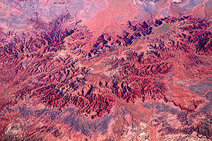

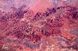
Badlands
A badlands is a type of dry terrain where softer sedimentary rocks and clay-rich soils have been extensively eroded by wind and water. It can resemble malpaís, a terrain of volcanic rock. Canyons, ravines, gullies, hoodoos and other such geological forms are common in badlands. They are often...
located in Northern Arizona
Northern Arizona
Northern Arizona is an unofficial, colloquially-defined region of the U.S. state of Arizona. It is dominated by the Colorado Plateau, the southern border of which in Arizona is called the Mogollon Rim. In the West lies the Grand Canyon, which was cut by the flow of the Colorado River while the...
in the United States. The Arizona desert
Desert
A desert is a landscape or region that receives an extremely low amount of precipitation, less than enough to support growth of most plants. Most deserts have an average annual precipitation of less than...
stretches from the Grand Canyon National Park
Grand Canyon National Park
Grand Canyon National Park is the United States' 15th oldest national park and is located in Arizona. Within the park lies the Grand Canyon, a gorge of the Colorado River, considered to be one of the Wonders of the World. The park covers of unincorporated area in Coconino and Mohave counties.Most...
into the Petrified Forest National Park
Petrified Forest National Park
Petrified Forest National Park is a United States national park in Navajo and Apache counties in northeastern Arizona. The park's headquarters are about east of Holbrook along Interstate 40 , which parallels a railroad line, the Puerco River, and historic U.S. Route 66, all crossing the park...
and runs roughly astride and just north of the Little Colorado
Little Colorado River
The Little Colorado River is a river in the U.S. state of Arizona, providing the principal drainage from the Painted Desert region. Together with its major tributary, the Puerco River, it drains an area of about in eastern Arizona and western New Mexico...
and the Puerco
Puerco River
The Puerco River in northwestern New Mexico and northeastern Arizona flows through arid terrain including the Painted Desert. The main tributary of the Little Colorado River, it drains an area of about and is long. The river's average discharge is very low, less than in normal years, because its...
Rivers. Much of the area within the Petrified Forest National Park is protected as the Petrified Forest National Wilderness Area. Another, smaller protected area
Protected area
Protected areas are locations which receive protection because of their recognised natural, ecological and/or cultural values. There are several kinds of protected areas, which vary by level of protection depending on the enabling laws of each country or the regulations of the international...
is the Little Painted Desert County Park, found just north of Winslow
Winslow, Arizona
-Demographics:As of the census of 2000, there were 9,520 people, 2,754 households, and 1,991 families residing in the city. The population density was 773.1 people per square mile . There were 3,198 housing units at an average density of 259.7 per square mile...
.
Much of the Painted Desert region is located within the Navajo Nation
Navajo Nation
The Navajo Nation is a semi-autonomous Native American-governed territory covering , occupying all of northeastern Arizona, the southeastern portion of Utah, and northwestern New Mexico...
. The Navajo
Navajo people
The Navajo of the Southwestern United States are the largest single federally recognized tribe of the United States of America. The Navajo Nation has 300,048 enrolled tribal members. The Navajo Nation constitutes an independent governmental body which manages the Navajo Indian reservation in the...
and the Hopi
Hopi
The Hopi are a federally recognized tribe of indigenous Native American people, who primarily live on the Hopi Reservation in northeastern Arizona. The Hopi area according to the 2000 census has a population of 6,946 people. Their Hopi language is one of the 30 of the Uto-Aztecan language...
people have lived in the region for at least five hundred and one thousand years, respectively.
The popular name for the desert comes from the Colonial Spanish
Spanish colonization of the Americas
Colonial expansion under the Spanish Empire was initiated by the Spanish conquistadores and developed by the Monarchy of Spain through its administrators and missionaries. The motivations for colonial expansion were trade and the spread of the Christian faith through indigenous conversions...
who are said to have named it El Desierto Pintado due to its brightly colored landscape.
Geology
The desert is composed of stratified layers of easily erodible siltstoneSiltstone
Siltstone is a sedimentary rock which has a grain size in the silt range, finer than sandstone and coarser than claystones.- Description :As its name implies, it is primarily composed of silt sized particles, defined as grains 1/16 - 1/256 mm or 4 to 8 on the Krumbein phi scale...
, mudstone
Mudstone
Mudstone is a fine grained sedimentary rock whose original constituents were clays or muds. Grain size is up to 0.0625 mm with individual grains too small to be distinguished without a microscope. With increased pressure over time the platey clay minerals may become aligned, with the...
, and shale
Shale
Shale is a fine-grained, clastic sedimentary rock composed of mud that is a mix of flakes of clay minerals and tiny fragments of other minerals, especially quartz and calcite. The ratio of clay to other minerals is variable. Shale is characterized by breaks along thin laminae or parallel layering...
of the Triassic
Triassic
The Triassic is a geologic period and system that extends from about 250 to 200 Mya . As the first period of the Mesozoic Era, the Triassic follows the Permian and is followed by the Jurassic. Both the start and end of the Triassic are marked by major extinction events...
Chinle Formation
Chinle Formation
The Chinle is a geologic formation that is spread across the U.S. states of northern Arizona, Nevada, Utah, western New Mexico, and western Colorado. The Chinle is controversially considered to be synonymous to the Dockum Group in eastern Colorado, eastern New Mexico, southwestern Kansas, the...
. These fine grained rock layers contain abundant iron and manganese compounds which provide the pigments for the various colors of the region. Thin resistant lacustrine
Lake
A lake is a body of relatively still fresh or salt water of considerable size, localized in a basin, that is surrounded by land. Lakes are inland and not part of the ocean and therefore are distinct from lagoons, and are larger and deeper than ponds. Lakes can be contrasted with rivers or streams,...
limestone
Limestone
Limestone is a sedimentary rock composed largely of the minerals calcite and aragonite, which are different crystal forms of calcium carbonate . Many limestones are composed from skeletal fragments of marine organisms such as coral or foraminifera....
layers and volcanic flows cap the mesa
Mesa
A mesa or table mountain is an elevated area of land with a flat top and sides that are usually steep cliffs. It takes its name from its characteristic table-top shape....
s. Numerous layers of silicic volcanic ash
Volcanic ash
Volcanic ash consists of small tephra, which are bits of pulverized rock and glass created by volcanic eruptions, less than in diameter. There are three mechanisms of volcanic ash formation: gas release under decompression causing magmatic eruptions; thermal contraction from chilling on contact...
occur in the Chinle and provide the silica for the petrified logs
Petrified wood
Petrified wood is the name given to a special type of fossilized remains of terrestrial vegetation. It is the result of a tree having turned completely into stone by the process of permineralization...
of the area. The erosion of these layers has resulted in the formation of the badlands
Badlands
A badlands is a type of dry terrain where softer sedimentary rocks and clay-rich soils have been extensively eroded by wind and water. It can resemble malpaís, a terrain of volcanic rock. Canyons, ravines, gullies, hoodoos and other such geological forms are common in badlands. They are often...
topography of the region.
In the southern portions of the desert the remains of a Triassic
Triassic
The Triassic is a geologic period and system that extends from about 250 to 200 Mya . As the first period of the Mesozoic Era, the Triassic follows the Permian and is followed by the Jurassic. Both the start and end of the Triassic are marked by major extinction events...
period coniferous forest have fossilized over millions of years. Wind, water and soil erosion
Erosion
Erosion is when materials are removed from the surface and changed into something else. It only works by hydraulic actions and transport of solids in the natural environment, and leads to the deposition of these materials elsewhere...
continue to change the face of the landscape by shifting sediment
Sediment
Sediment is naturally occurring material that is broken down by processes of weathering and erosion, and is subsequently transported by the action of fluids such as wind, water, or ice, and/or by the force of gravity acting on the particle itself....
and exposing layers of the Chinle Formation
Chinle Formation
The Chinle is a geologic formation that is spread across the U.S. states of northern Arizona, Nevada, Utah, western New Mexico, and western Colorado. The Chinle is controversially considered to be synonymous to the Dockum Group in eastern Colorado, eastern New Mexico, southwestern Kansas, the...
. An assortment of fossilized prehistoric plants and animals are found in the region, as well as dinosaur
Dinosaur
Dinosaurs are a diverse group of animals of the clade and superorder Dinosauria. They were the dominant terrestrial vertebrates for over 160 million years, from the late Triassic period until the end of the Cretaceous , when the Cretaceous–Paleogene extinction event led to the extinction of...
tracks and the evidence of early human habitation.
Accessibility
Much of the region is accessible only by foot or unpaved road though major highways and paved roads cut across the area. The towns of CameronCameron, Arizona
Cameron is a census-designated place in Coconino County, Arizona, United States. The population was 978 at the 2000 census. Most of the town's economy is tourist food and craft stalls, restaurants, and other services for north-south traffic from Flagstaff and Page...
and Tuba City
Tuba City, Arizona
Tuba City is a census-designated place in Coconino County, Arizona, United States. The population was 8,225 at the 2000 census. It is the Dine' Nation's largest community, slightly larger than Shiprock, New Mexico. The Hopi town of Moenkopi lies directly to its southeast.The name of the town...
, both within the Navajo Nation, are two major settlements.