
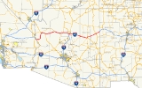
Interstate 40 in Arizona
Encyclopedia
Interstate 40 is an east–west Interstate Highway that has a 359.6 miles (578.72 km) section in the U.S. state
of Arizona
connecting sections in California
to New Mexico
. It enters Arizona from the west at a crossing of the Colorado River
southwest of Kingman
. It travels eastward across the northern portion of the state connecting the cities of Kingman
, Ash Fork, Williams
, Flagstaff
, Winslow
, and Holbrook
. I-40 continues into New Mexico, heading to Albuquerque
. The highway has major junctions with U.S. Route 93
(US 93) in Kingman, the main highway connecting Phoenix
and Las Vegas, Nevada
, and I-17
in Flagstaff, the Interstate linking Phoenix and Flagstaff.
For the majority of its routing through Arizona, I-40 follows the historic alignment of U.S. Route 66. The lone exception is a stretch between Kingman and Ash Fork
where US 66 took a more northerly, less direct route that is now State Route 66. Construction of I-40 was ongoing in the 1960s and 1970s and reached completion in 1984. With the completion of I-40 in 1984, the entire routing of US 66 had been bypassed by Interstate Highways which led to its decertification a year later in 1985.
 I-40 enters Arizona from California at a crossing of the Colorado River
at Topock
in Mohave County
. It heads east from Topock and begins to curve towards the north at Franconia and completes the curve to the north at Yucca
. The Interstate continues to head north until it reaches Kingman
. In Kingman, I-40 has a junction with US 93 at exit 48. US 93 heads towards the northwest from this junction to Hoover Dam
and Las Vegas
. US 93 south begins to run concurrently with I-40 as they both head east through Kingman. The two separate at exit 71 as US 93 heads towards the south towards Phoenix
while I-40 heads east towards Flagstaff. I-40 continues towards the east, passing through the town of Seligman then Ash Fork
, where in meets State Route 89, the main route south to Prescott
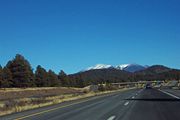
. Next it passes through Williams
; exit 165 SR 64 heads north towards the Grand Canyon National Park
. I-40 continues to the east to Flagstaff
, where it has a junction with I-17
at exit 195. I-17 heads south from the interchange with I-40 to Phoenix.
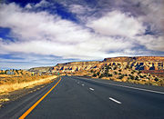
. It continues towards this direction until it reaches Holbrook
, where it curves towards the northeast. Along this stretch it passes through the Petrified Forest National Park
. It continues to the northeast, passing through Chambers
and enters the Navajo Indian Reservation. The highway continues to the northeast to the New Mexico
border southwest of Gallup, New Mexico
as it continues on towards Albuquerque
.
and his soldiers built the road along the 35th parallel that would come to be known as the Beale Wagon Road from Ft. Smith, Arkansas to the Colorado River
to serve as a military wagon road. The road was a popular route for immigrants during the 1860s and 1870s until the transcontinental railroad
was built across northern Arizona in the 1880s. In the early 1900s, the road became part of the National Old Trails Road, a transcontinental route from Baltimore, Maryland to California
, and the National Park to Park Highway
, an auto trail linking the national parks of the west.
was being developed, the route through was given the designation of U.S. Route 60. This designation was controversial since designations that are multiples of 10 are assigned to transcontinental east–west routes and this route was a diagonal route from Chicago to Los Angeles
. As a compromise to states east of Chicago that felt US 60 should go through their state, a different route was given the number 60, while the route from Chicago to Los Angeles was given the number 66.
 By 1927, the routing of US 66 through Arizona had been laid out, but none of it had been paved yet. By 1935, nearly the entire route had been paved, with the lone exceptions being a short stretch northeast of Valentine
and a stretch between Peach Springs
and Seligman
. By 1938, the entire route in Arizona had been paved. In 1953, US 66 was realigned between the California border and Kingman
to an alignment to the southeast to avoid the mountain curves and grades of the original alignment. By 1961, several sections of the highway had been expanded to a four-lane divided highway in anticipation of the coming Interstate Highway. Four-lane sections included a section near Ash Fork, another section east of Winslow and a section east of Holbrook near the Petrified Forest National Monument.
. This recommendation was accepted and would become the planned routing of I-40 in Flagstaff. Business owners along US 66 were opposed to this routing as it would draw motorists away from main through route of the time, US 66. As a result, they created the No By-Pass Committee and sent a proposal to the Chamber of Commerce’s Roads and Highways Committee to conduct a study of the feasibility of a route for I-40 through downtown along the Santa Fe railroad right-of-way. The Committee sent an inquiry to the railroad concerning the proposal. The railroad rejected the proposed rerouting of their main rail lines citing that it would result in worse grades than what currently exists and in order to reduce those grades, considerable lengthening of the rail line would be required. With a routing through town now out of the question, the business owners along US 66 drafted a city ordinance, known as Initiative 200, that was filed with the city of Flagstaff in November 1959 to appear on the general election ballot in March 1960. The ordinance would in effect ban all new commercial businesses on I-40, all routes leading from I-40 to US 66, and the area between I-40 and US 66. In a record voter turnout, voters overwhelmingly voted against the ordinance by a vote of 2,280 to 556.
In 1965, the routing of I-40 west of Kingman was being reconsidered from the planned route through Needles, California
to a route to the north passing through Searchlight
in southern Nevada and connecting with I-15 further north of its present connection with I-15. The rationale for the proposal was that it would be an overall shorter route and would cost much less to construct. The proposal was met with stiff opposition including all four U.S. senators from California and Arizona sending the Secretary of Commerce letters requesting that the routing through Needles be retained. This proposal was eventually abandoned in 1966 and the routing through Needles was kept.
 The construction of the 360 miles (579 km) route of I-40 across Arizona took nearly 25 years to complete with the last segment being completed in 1984, much longer than the ambitious goal of finishing by 1972. By the end of 1960, 15 miles (24 km) had been completed with an additional 23 miles (37 km) miles being worked on. In 1964, construction was still on schedule with 58 miles (93 km) complete and an additional 71 miles (114 km) under construction. Funding was becoming an issue at this time as the state lacked the available funds to stay on pace with a 1972 completion goal. By 1967, Arizona had completed approximately half of the highway with 155.3 miles (249.9 km) complete and another 82.4 miles (133 km) under construction. In 1968, the bypass around Flagstaff was complete with three interchanges, two at each end of where US 66 split off from I-40 to enter the city and one at the I-17 interchange. An additional interchange at Butler Avenue was completed a year later. One of the big improvements of I-40 over US 66 was the construction of the segment between Kingman and Ash Fork. The 94 miles (151 km) section is a more direct route between the two cities and travels as far as 20 miles (32 km) south of the US 66 alignment. Construction of the $69.1 million segment was also to be a much safer route as the US 66 alignment had one of the highest fatality rates of any section of highway in Arizona. This section of the Interstate was complete in 1975. Construction of the $7.7 million bypass around Winslow began in 1977. I-40 was completed in Arizona in 1984, with the completion of a 6 miles (10 km) section in Williams. This was also the last section of US 66 to be bypassed by the Interstate, which led to it being decertified by the American Association of State Highway and Transportation Officials
(AASHTO) the following year.
U.S. state
A U.S. state is any one of the 50 federated states of the United States of America that share sovereignty with the federal government. Because of this shared sovereignty, an American is a citizen both of the federal entity and of his or her state of domicile. Four states use the official title of...
of Arizona
Arizona
Arizona ; is a state located in the southwestern region of the United States. It is also part of the western United States and the mountain west. The capital and largest city is Phoenix...
connecting sections in California
California
California is a state located on the West Coast of the United States. It is by far the most populous U.S. state, and the third-largest by land area...
to New Mexico
New Mexico
New Mexico is a state located in the southwest and western regions of the United States. New Mexico is also usually considered one of the Mountain States. With a population density of 16 per square mile, New Mexico is the sixth-most sparsely inhabited U.S...
. It enters Arizona from the west at a crossing of the Colorado River
Colorado River
The Colorado River , is a river in the Southwestern United States and northwestern Mexico, approximately long, draining a part of the arid regions on the western slope of the Rocky Mountains. The watershed of the Colorado River covers in parts of seven U.S. states and two Mexican states...
southwest of Kingman
Kingman, Arizona
Kingman is located in a desert climate on the edge of the Mojave Desert, but its higher elevation and location between the Colorado Plateau and the Lower Colorado River Valley tempers summer high temperatures and contributes to winter cold and rare snowfall. Summer daytime highs reach above 90 °F ...
. It travels eastward across the northern portion of the state connecting the cities of Kingman
Kingman, Arizona
Kingman is located in a desert climate on the edge of the Mojave Desert, but its higher elevation and location between the Colorado Plateau and the Lower Colorado River Valley tempers summer high temperatures and contributes to winter cold and rare snowfall. Summer daytime highs reach above 90 °F ...
, Ash Fork, Williams
Williams, Arizona
Williams is a city in Coconino County, Arizona, United States west of Flagstaff. Its population was 2,842 at the 2000 census; according to 2006 Census Bureau estimates, the population of the city is 3,094. It lies on the route of Historic Route 66, Interstate 40, and the Southwest Chief Amtrak...
, Flagstaff
Flagstaff, Arizona
Flagstaff is a city located in northern Arizona, in the southwestern United States. In 2010, the city's population was 65,870. The population of the Metropolitan Statistical Area was at 134,421 in 2010. It is the county seat of Coconino County...
, Winslow
Winslow, Arizona
-Demographics:As of the census of 2000, there were 9,520 people, 2,754 households, and 1,991 families residing in the city. The population density was 773.1 people per square mile . There were 3,198 housing units at an average density of 259.7 per square mile...
, and Holbrook
Holbrook, Arizona
-Historical events:*During 1881 & 1882, railroad tracks were laid down and a railroad station was built. The community was then named Holbrook after the first engineer of the Atlantic and Pacific Railroad...
. I-40 continues into New Mexico, heading to Albuquerque
Albuquerque, New Mexico
Albuquerque is the largest city in the state of New Mexico, United States. It is the county seat of Bernalillo County and is situated in the central part of the state, straddling the Rio Grande. The city population was 545,852 as of the 2010 Census and ranks as the 32nd-largest city in the U.S. As...
. The highway has major junctions with U.S. Route 93
U.S. Route 93 in Arizona
In the U.S. state of Arizona, U.S. Route 93 is a U.S. Highway that begins in Wickenburg and heads north to the Nevada border at the Mike O'Callaghan – Pat Tillman Memorial Bridge....
(US 93) in Kingman, the main highway connecting Phoenix
Phoenix, Arizona
Phoenix is the capital, and largest city, of the U.S. state of Arizona, as well as the sixth most populated city in the United States. Phoenix is home to 1,445,632 people according to the official 2010 U.S. Census Bureau data...
and Las Vegas, Nevada
Las Vegas, Nevada
Las Vegas is the most populous city in the U.S. state of Nevada and is also the county seat of Clark County, Nevada. Las Vegas is an internationally renowned major resort city for gambling, shopping, and fine dining. The city bills itself as The Entertainment Capital of the World, and is famous...
, and I-17
Interstate 17
Interstate 17 , also known as the Black Canyon Freeway, is an intrastate Interstate Highway located entirely within the state of Arizona, United States. I-17's southern terminus lies within Phoenix, at Interstate 10, and its northern terminus is in Flagstaff, at Interstate 40...
in Flagstaff, the Interstate linking Phoenix and Flagstaff.
For the majority of its routing through Arizona, I-40 follows the historic alignment of U.S. Route 66. The lone exception is a stretch between Kingman and Ash Fork
Ash Fork, Arizona
Ash Fork is a census-designated place in Yavapai County, Arizona, United States. The population was 457 at the 2000 census.-Geography:Ash Fork is located at ....
where US 66 took a more northerly, less direct route that is now State Route 66. Construction of I-40 was ongoing in the 1960s and 1970s and reached completion in 1984. With the completion of I-40 in 1984, the entire routing of US 66 had been bypassed by Interstate Highways which led to its decertification a year later in 1985.
California to Flagstaff
Colorado River
The Colorado River , is a river in the Southwestern United States and northwestern Mexico, approximately long, draining a part of the arid regions on the western slope of the Rocky Mountains. The watershed of the Colorado River covers in parts of seven U.S. states and two Mexican states...
at Topock
Topock, Arizona
Topock is a small unincorporated community in Mohave County, Arizona. Topock has a ZIP Code of 86436; in 2000, the population of the 86436 ZCTA was 1,790....
in Mohave County
Mohave County, Arizona
Mohave County is located in the northwestern corner of the U.S. state of Arizona. As of the 2010 census, its population was 200,186, an increase of 45,154 people since the 2000 census count of 155,032. The county seat is Kingman...
. It heads east from Topock and begins to curve towards the north at Franconia and completes the curve to the north at Yucca
Yucca, Arizona
Yucca is an unincorporated community in Mohave County, Arizona, United States. Located along Interstate 40, it lies southwest of Kingman, just east of the southern section of the Black Mountains and west of the Hualapai and McCracken Mountains in the Sacramento Valley. Yucca has a ZIP Code of...
. The Interstate continues to head north until it reaches Kingman
Kingman, Arizona
Kingman is located in a desert climate on the edge of the Mojave Desert, but its higher elevation and location between the Colorado Plateau and the Lower Colorado River Valley tempers summer high temperatures and contributes to winter cold and rare snowfall. Summer daytime highs reach above 90 °F ...
. In Kingman, I-40 has a junction with US 93 at exit 48. US 93 heads towards the northwest from this junction to Hoover Dam
Hoover Dam
Hoover Dam, once known as Boulder Dam, is a concrete arch-gravity dam in the Black Canyon of the Colorado River, on the border between the US states of Arizona and Nevada. It was constructed between 1931 and 1936 during the Great Depression and was dedicated on September 30, 1935, by President...
and Las Vegas
Las Vegas, Nevada
Las Vegas is the most populous city in the U.S. state of Nevada and is also the county seat of Clark County, Nevada. Las Vegas is an internationally renowned major resort city for gambling, shopping, and fine dining. The city bills itself as The Entertainment Capital of the World, and is famous...
. US 93 south begins to run concurrently with I-40 as they both head east through Kingman. The two separate at exit 71 as US 93 heads towards the south towards Phoenix
Phoenix, Arizona
Phoenix is the capital, and largest city, of the U.S. state of Arizona, as well as the sixth most populated city in the United States. Phoenix is home to 1,445,632 people according to the official 2010 U.S. Census Bureau data...
while I-40 heads east towards Flagstaff. I-40 continues towards the east, passing through the town of Seligman then Ash Fork
Ash Fork, Arizona
Ash Fork is a census-designated place in Yavapai County, Arizona, United States. The population was 457 at the 2000 census.-Geography:Ash Fork is located at ....
, where in meets State Route 89, the main route south to Prescott
Prescott, Arizona
Prescott is a city in Yavapai County, Arizona, USA. It was designated "Arizona's Christmas City" by Arizona Governor Rose Mofford in the late 1980s....
. Next it passes through Williams
Williams, Arizona
Williams is a city in Coconino County, Arizona, United States west of Flagstaff. Its population was 2,842 at the 2000 census; according to 2006 Census Bureau estimates, the population of the city is 3,094. It lies on the route of Historic Route 66, Interstate 40, and the Southwest Chief Amtrak...
; exit 165 SR 64 heads north towards the Grand Canyon National Park
Grand Canyon National Park
Grand Canyon National Park is the United States' 15th oldest national park and is located in Arizona. Within the park lies the Grand Canyon, a gorge of the Colorado River, considered to be one of the Wonders of the World. The park covers of unincorporated area in Coconino and Mohave counties.Most...
. I-40 continues to the east to Flagstaff
Flagstaff, Arizona
Flagstaff is a city located in northern Arizona, in the southwestern United States. In 2010, the city's population was 65,870. The population of the Metropolitan Statistical Area was at 134,421 in 2010. It is the county seat of Coconino County...
, where it has a junction with I-17
Interstate 17
Interstate 17 , also known as the Black Canyon Freeway, is an intrastate Interstate Highway located entirely within the state of Arizona, United States. I-17's southern terminus lies within Phoenix, at Interstate 10, and its northern terminus is in Flagstaff, at Interstate 40...
at exit 195. I-17 heads south from the interchange with I-40 to Phoenix.
Flagstaff to New Mexico
East of Flagstaff, I-40 heads towards the east-southeast as it heads to the town of WinslowWinslow, Arizona
-Demographics:As of the census of 2000, there were 9,520 people, 2,754 households, and 1,991 families residing in the city. The population density was 773.1 people per square mile . There were 3,198 housing units at an average density of 259.7 per square mile...
. It continues towards this direction until it reaches Holbrook
Holbrook, Arizona
-Historical events:*During 1881 & 1882, railroad tracks were laid down and a railroad station was built. The community was then named Holbrook after the first engineer of the Atlantic and Pacific Railroad...
, where it curves towards the northeast. Along this stretch it passes through the Petrified Forest National Park
Petrified Forest National Park
Petrified Forest National Park is a United States national park in Navajo and Apache counties in northeastern Arizona. The park's headquarters are about east of Holbrook along Interstate 40 , which parallels a railroad line, the Puerco River, and historic U.S. Route 66, all crossing the park...
. It continues to the northeast, passing through Chambers
Chambers, Arizona
Chambers is an unincorporated community in Apache County, Arizona, United States. Chambers is located at the junction of Interstate 40 and U.S. Route 191 northeast of Holbrook. Chambers has a post office with ZIP code 86502....
and enters the Navajo Indian Reservation. The highway continues to the northeast to the New Mexico
New Mexico
New Mexico is a state located in the southwest and western regions of the United States. New Mexico is also usually considered one of the Mountain States. With a population density of 16 per square mile, New Mexico is the sixth-most sparsely inhabited U.S...
border southwest of Gallup, New Mexico
Gallup, New Mexico
- Demographics :As of the census of 2000, there were 20,209 people, 6,810 households, and 4,869 families residing in the city. The population density was 1,513.7 people per square mile...
as it continues on towards Albuquerque
Albuquerque, New Mexico
Albuquerque is the largest city in the state of New Mexico, United States. It is the county seat of Bernalillo County and is situated in the central part of the state, straddling the Rio Grande. The city population was 545,852 as of the 2010 Census and ranks as the 32nd-largest city in the U.S. As...
.
History
With the exception of a stretch between Kingman and Flagstaff, I-40 directly replaced the famed US 66 across northern Arizona. Where possible, US 66 was upgraded to Interstate standards to become I-40 directly. Exceptions to this were through the central business districts of the cities and towns that US 66 passed through, and I-40 had to be built as a bypass outside the cities. On October 26, 1984, after the last section of I-40 was completed in Williams, US 66 was removed from the state highway system of Arizona. The portions through cities that did not overlap I-40 would become business loops of I-40.Before the U.S. Highways
The routing of a road near the current corridor of I-40 in Arizona was first surveyed and built between 1857 and 1859. Lt. Edward BealeEdward Fitzgerald Beale
Edward Fitzgerald "Ned" Beale was a national figure in 19th century America. He was naval officer, military general, explorer, frontiersman, Indian affairs superintendent, California rancher, diplomat, and friend of Kit Carson, Buffalo Bill Cody and Ulysses S. Grant...
and his soldiers built the road along the 35th parallel that would come to be known as the Beale Wagon Road from Ft. Smith, Arkansas to the Colorado River
Colorado River
The Colorado River , is a river in the Southwestern United States and northwestern Mexico, approximately long, draining a part of the arid regions on the western slope of the Rocky Mountains. The watershed of the Colorado River covers in parts of seven U.S. states and two Mexican states...
to serve as a military wagon road. The road was a popular route for immigrants during the 1860s and 1870s until the transcontinental railroad
Transcontinental railroad
A transcontinental railroad is a contiguous network of railroad trackage that crosses a continental land mass with terminals at different oceans or continental borders. Such networks can be via the tracks of either a single railroad, or over those owned or controlled by multiple railway companies...
was built across northern Arizona in the 1880s. In the early 1900s, the road became part of the National Old Trails Road, a transcontinental route from Baltimore, Maryland to California
California
California is a state located on the West Coast of the United States. It is by far the most populous U.S. state, and the third-largest by land area...
, and the National Park to Park Highway
National Park to Park Highway
The National Park to Park Highway was an auto trail in the United States in the 1910s and 1920s, plotted by A. L. Westgard. It followed a large loop through the West, connecting twelve National Parks:*Rocky Mountain National Park*Yellowstone National Park...
, an auto trail linking the national parks of the west.
U.S. Route 66
In the 1920s, as a nationwide system of highways called the United States Numbered HighwaysUnited States Numbered Highways
The system of United States Numbered Highways is an integrated system of roads and highways in the United States numbered within a nationwide grid...
was being developed, the route through was given the designation of U.S. Route 60. This designation was controversial since designations that are multiples of 10 are assigned to transcontinental east–west routes and this route was a diagonal route from Chicago to Los Angeles
Los Angeles, California
Los Angeles , with a population at the 2010 United States Census of 3,792,621, is the most populous city in California, USA and the second most populous in the United States, after New York City. It has an area of , and is located in Southern California...
. As a compromise to states east of Chicago that felt US 60 should go through their state, a different route was given the number 60, while the route from Chicago to Los Angeles was given the number 66.
Valentine, Arizona
Valentine is an unincorporated community in Mohave County, Arizona, United States. Valentine is located on Arizona State Route 66 northeast of Kingman. Valentine has a ZIP Code of 86437; in 2000, the population of the 86437 ZCTA was 36....
and a stretch between Peach Springs
Peach Springs, Arizona
Peach Springs is a census-designated place in Mohave County, Arizona, United States. The population was 600 at the 2000 census. Peach Springs serves as the administrative headquarters of the Hualapai people, and is located on the Hualapai Reservation.-Geography:Peach Springs is located at ...
and Seligman
Seligman, Arizona
Seligman is a census-designated place in Yavapai County, Arizona, United States. The population was 456 at the 2000 census.-History:Between 1889-1891, Seligman was established by the Theut and Moultrie families. Both were prosperous slaughterhouse owners in Southern antebellum families who lost...
. By 1938, the entire route in Arizona had been paved. In 1953, US 66 was realigned between the California border and Kingman
Kingman, Arizona
Kingman is located in a desert climate on the edge of the Mojave Desert, but its higher elevation and location between the Colorado Plateau and the Lower Colorado River Valley tempers summer high temperatures and contributes to winter cold and rare snowfall. Summer daytime highs reach above 90 °F ...
to an alignment to the southeast to avoid the mountain curves and grades of the original alignment. By 1961, several sections of the highway had been expanded to a four-lane divided highway in anticipation of the coming Interstate Highway. Four-lane sections included a section near Ash Fork, another section east of Winslow and a section east of Holbrook near the Petrified Forest National Monument.
Planning
In Flagstaff, several different alternatives were considered as a potential routing of the new Interstate through the area. The alternatives consisted of a routing north of downtown, south of downtown, through downtown along the Santa Fe Railroad right-of-way near the alignment of US 66, and a more elaborate alternative of a routing above downtown on a long overpass. In January 1959, the Flagstaff Chamber of Commerce recommended to the Bureau of Public Roads that the route south of downtown be used which was approved by the Flagstaff City Council and the Board of Supervisors for Coconino CountyCoconino County, Arizona
-2010:Whereas according to the 2010 U.S. Census Bureau:*61.7% White*1.2% Black*27.3% Native American*1.4% Asian*0.1% Native Hawaiian or Pacific Islander*3.1% Two or more races*5.2% Other races*13.5% Hispanic or Latino -2000:...
. This recommendation was accepted and would become the planned routing of I-40 in Flagstaff. Business owners along US 66 were opposed to this routing as it would draw motorists away from main through route of the time, US 66. As a result, they created the No By-Pass Committee and sent a proposal to the Chamber of Commerce’s Roads and Highways Committee to conduct a study of the feasibility of a route for I-40 through downtown along the Santa Fe railroad right-of-way. The Committee sent an inquiry to the railroad concerning the proposal. The railroad rejected the proposed rerouting of their main rail lines citing that it would result in worse grades than what currently exists and in order to reduce those grades, considerable lengthening of the rail line would be required. With a routing through town now out of the question, the business owners along US 66 drafted a city ordinance, known as Initiative 200, that was filed with the city of Flagstaff in November 1959 to appear on the general election ballot in March 1960. The ordinance would in effect ban all new commercial businesses on I-40, all routes leading from I-40 to US 66, and the area between I-40 and US 66. In a record voter turnout, voters overwhelmingly voted against the ordinance by a vote of 2,280 to 556.
In 1965, the routing of I-40 west of Kingman was being reconsidered from the planned route through Needles, California
Needles, California
Needles is a city located in the Mojave Desert on the western banks of the Colorado River in San Bernardino County, California. It is located in the Mohave Valley, which straddles the California–Arizona border. The city is accessible via Interstate 40 and U.S. Route 95...
to a route to the north passing through Searchlight
Searchlight, Nevada
Searchlight is an unincorporated town in Clark County, Nevada, at the topographic saddle between two mountain ranges.-History:According to Nevada Senator Harry Reid, who has written extensively about his hometown, the most likely story as to how the town received its name was when George Frederick...
in southern Nevada and connecting with I-15 further north of its present connection with I-15. The rationale for the proposal was that it would be an overall shorter route and would cost much less to construct. The proposal was met with stiff opposition including all four U.S. senators from California and Arizona sending the Secretary of Commerce letters requesting that the routing through Needles be retained. This proposal was eventually abandoned in 1966 and the routing through Needles was kept.
Construction
American Association of State Highway and Transportation Officials
AASHTO, the American Association of State Highway and Transportation Officials, is a standards setting body which publishes specifications, test protocols and guidelines which are used in highway design and construction throughout the United States...
(AASHTO) the following year.
Exit list
| County | Location | Mile | # Exit number An exit number is a number assigned to a road junction, usually an exit from a freeway. It is usually marked on the same sign as the destinations of the exit, as well as a sign in the gore.... |
Destinations | Notes |
|---|---|---|---|---|---|
| Mohave Mohave County, Arizona Mohave County is located in the northwestern corner of the U.S. state of Arizona. As of the 2010 census, its population was 200,186, an increase of 45,154 people since the 2000 census count of 155,032. The county seat is Kingman... |
Topock Topock, Arizona Topock is a small unincorporated community in Mohave County, Arizona. Topock has a ZIP Code of 86436; in 2000, the population of the 86436 ZCTA was 1,790.... |
0.55 | 1 | West end of SR 95 overlap | |
| 2.99 | 2 | Needle Mountain Road | |||
| 9.79 | 9 | East end of SR 95 overlap | |||
| 13.16 | 13 | Franconia Road | |||
| 20.14 | 20 | Santa Fe Ranch Road | |||
| Yucca Yucca, Arizona Yucca is an unincorporated community in Mohave County, Arizona, United States. Located along Interstate 40, it lies southwest of Kingman, just east of the southern section of the Black Mountains and west of the Hualapai and McCracken Mountains in the Sacramento Valley. Yucca has a ZIP Code of... |
25.19 | 25 | Alamo Road | ||
| 26.18 | 26 | Proving Ground Road | No westbound entrance | ||
| 28.75 | 28 | Old Trails Road | |||
| 37.03 | 37 | Griffith Road | |||
| 44.32 | 44 | Shinarump Drive, Oatman Highway | |||
| Kingman Kingman, Arizona Kingman is located in a desert climate on the edge of the Mojave Desert, but its higher elevation and location between the Colorado Plateau and the Lower Colorado River Valley tempers summer high temperatures and contributes to winter cold and rare snowfall. Summer daytime highs reach above 90 °F ... |
48.86 | 48 | .svg.png) – Las Vegas – Las VegasLas Vegas, Nevada Las Vegas is the most populous city in the U.S. state of Nevada and is also the county seat of Clark County, Nevada. Las Vegas is an internationally renowned major resort city for gambling, shopping, and fine dining. The city bills itself as The Entertainment Capital of the World, and is famous... |
West end of US 93 overlap | |
| 51.69 | 52 | Stockton Hill Road | |||
| 53.07 | 53 | — Kingman Airport Kingman Airport (Arizona) Kingman Airport is a city-owned, public-use airport located eight nautical miles northeast of the central business district of Kingman, a city in Mohave County, Arizona, United States. It has scheduled service provided by one commercial airline, which is subsidized by the Essential Air Service... |
|||
| 59.21 | 59 | DW Ranch Road | |||
| 66.02 | 66 | Blake Ranch Road | |||
| 71.52 | 71 | East end of US 93 overlap | |||
| 78.90 | 79 | Silver Springs Road | |||
| 87.01 | 87 | Willows Ranch Road | |||
| 91.12 | 91 | Fort Rock Road | |||
| Yavapai Yavapai County, Arizona -2010:Whereas according to the 2010 U.S. Census Bureau:*89.3% White*0.6% Black*1.7% Native American*0.8% Asian*0.1% Native Hawaiian or Pacific Islander*2.5% Two or more races*5.0% Other races*13.6% Hispanic or Latino -2000:... |
95.45 | 96 | Cross Mountain Road | ||
| 102.99 | 103 | Jolly Road | |||
| 109.07 | 109 | Anvil Rock Road | |||
| Seligman Seligman, Arizona Seligman is a census-designated place in Yavapai County, Arizona, United States. The population was 456 at the 2000 census.-History:Between 1889-1891, Seligman was established by the Theut and Moultrie families. Both were prosperous slaughterhouse owners in Southern antebellum families who lost... |
120.49 | 121 | |||
| 122.72 | 123 | ||||
| 139.28 | 139 | Crookton Road | Former US 66 west | ||
| Ash Fork Ash Fork, Arizona Ash Fork is a census-designated place in Yavapai County, Arizona, United States. The population was 457 at the 2000 census.-Geography:Ash Fork is located at .... |
144.37 | 145 | |||
| 145.69 | 146 | West end of SR 89 overlap | |||
| Coconino Coconino County, Arizona -2010:Whereas according to the 2010 U.S. Census Bureau:*61.7% White*1.2% Black*27.3% Native American*1.4% Asian*0.1% Native Hawaiian or Pacific Islander*3.1% Two or more races*5.2% Other races*13.5% Hispanic or Latino -2000:... |
147.68 | 148 | County Line Road | ||
| 148.57 | 149 | Monte Carlo Road | |||
| 151.23 | 151 | Welch Road | |||
| 157.20 | 157 | Devil Dog Road | |||
| Williams Williams, Arizona Williams is a city in Coconino County, Arizona, United States west of Flagstaff. Its population was 2,842 at the 2000 census; according to 2006 Census Bureau estimates, the population of the city is 3,094. It lies on the route of Historic Route 66, Interstate 40, and the Southwest Chief Amtrak... |
161.38 | 161 | , Grand Canyon National Park Grand Canyon National Park Grand Canyon National Park is the United States' 15th oldest national park and is located in Arizona. Within the park lies the Grand Canyon, a gorge of the Colorado River, considered to be one of the Wonders of the World. The park covers of unincorporated area in Coconino and Mohave counties.Most... |
||
| 162.95 | 163 | Williams Williams, Arizona Williams is a city in Coconino County, Arizona, United States west of Flagstaff. Its population was 2,842 at the 2000 census; according to 2006 Census Bureau estimates, the population of the city is 3,094. It lies on the route of Historic Route 66, Interstate 40, and the Southwest Chief Amtrak... , Grand Canyon National Park Grand Canyon National Park Grand Canyon National Park is the United States' 15th oldest national park and is located in Arizona. Within the park lies the Grand Canyon, a gorge of the Colorado River, considered to be one of the Wonders of the World. The park covers of unincorporated area in Coconino and Mohave counties.Most... |
|||
| 165.41 | 165 | , Grand Canyon National Park Grand Canyon National Park Grand Canyon National Park is the United States' 15th oldest national park and is located in Arizona. Within the park lies the Grand Canyon, a gorge of the Colorado River, considered to be one of the Wonders of the World. The park covers of unincorporated area in Coconino and Mohave counties.Most... |
Former US 66 west | ||
| 167.09 | 167 | Garland Prairie Road, Circle Pines Road | |||
| 171.10 | 171 | Pittman Valley Road, Deer Farm Road | |||
| 177.81 | 178 | Parks Road | |||
| 184.68 | 185 | Transwestern Road – Bellemont Bellemont, Arizona Bellemont is an unincorporated community in Coconino County, Arizona, United States. Bellemont is located along Interstate 40 west-northwest of Flagstaff. Bellemont has a ZIP Code of 86015; in 2000, the population of the 86015 ZCTA was 231.... /Navajo Army Depot |
|||
| 190.10 | 190 | A-1 Mountain Road | |||
| 191.26 | 191 | ||||
| 192.12 | 192 | Flagstaff Ranch Road | |||
| Flagstaff Flagstaff, Arizona Flagstaff is a city located in northern Arizona, in the southwestern United States. In 2010, the city's population was 65,870. The population of the Metropolitan Statistical Area was at 134,421 in 2010. It is the county seat of Coconino County... |
194.63 195.25 |
195 | |||
| 197.86 | 198 | Butler Avenue | |||
| 200.65 | 201 | West end of US 180 overlap | |||
| 204.42 | 204 | Walnut Canyon National Monument Walnut Canyon National Monument Walnut Canyon National Monument is a United States National Monument located about southeast of downtown Flagstaff, Arizona, just off Interstate 40. The canyon rim lies at ; the canyon's floor is 350 ft lower... |
|||
| 206.79 | 207 | Cosnino Road | |||
| 210.72 | 211 | Winona Winona, Arizona Winona is a small unincorporated community in Coconino County in the northern part of the U.S. state of Arizona.It is located along U.S. Route 66 and was made famous in the song " Route 66"... |
|||
| 219.13 | 219 | Twin Arrows | |||
| 224.60 | 225 | Buffalo Range Road | |||
| 230.01 | 230 | Two Guns | |||
| 233.43 | 233 | Meteor Crater Road | |||
| 239.22 | 239 | Meteor City Road | |||
| 244.94 | 245 | West end of SR 99 overlap | |||
| Navajo Navajo County, Arizona -2010:Whereas according to the 2010 U.S. Census Bureau:*49.3% White*0.9% Black*43.4% Native American*0.5% Asian*0.1% Native Hawaiian or Pacific Islander*2.5% Two or more races*3.3% Other races*10.8% Hispanic or Latino -2000:... |
Winslow Winslow, Arizona -Demographics:As of the census of 2000, there were 9,520 people, 2,754 households, and 1,991 families residing in the city. The population density was 773.1 people per square mile . There were 3,198 housing units at an average density of 259.7 per square mile... |
251.58 | 252 | East end of SR 99 overlap | |
| 253.08 | 253 | North Park Drive | |||
| 255.21 | 255 | ||||
| 257.16 | 257 | ||||
| 264.18 | 264 | Hibbard Road | |||
| 269.43 | 269 | Jackrabbit Road | |||
| Joseph City Joseph City, Arizona Joseph City is an unincorporated community located in Navajo County, Arizona, United States. It is located on Interstate 40 about eighty miles east of Flagstaff.... |
274.19 | 274 | |||
| 276.55 | 277 | ||||
| 280.13 | 280 | Hunt Road, Geronimo Road | |||
| 283.13 | 283 | Perkins Valley Road | |||
| Holbrook Holbrook, Arizona -Historical events:*During 1881 & 1882, railroad tracks were laid down and a railroad station was built. The community was then named Holbrook after the first engineer of the Atlantic and Pacific Railroad... |
284.67 | 285 | , Petrified Forest National Park Petrified Forest National Park Petrified Forest National Park is a United States national park in Navajo and Apache counties in northeastern Arizona. The park's headquarters are about east of Holbrook along Interstate 40 , which parallels a railroad line, the Puerco River, and historic U.S. Route 66, all crossing the park... |
East end of US 180 overlap; Westbound exit is via exit 286 | |
| 286.38 | 286 | West end of SR 77 overlap; Eastbound exit is via exit 285 | |||
| 289.00 | 289 | ||||
| 292.32 | 292 | East end of SR 77 overlap | |||
| 294.03 | 294 | Sun Valley Road | |||
| 299.67 | 300 | Goodwater | |||
| 303.09 | 303 | Adamana Road | |||
| Apache Apache County, Arizona -2010:Whereas according to the 2010 U.S. Census Bureau:*23.3% White*0.2% Black*72.9% Native American*0.3% Asian*0.0% Native Hawaiian or Pacific Islander*2.0% Two or more races*1.3% Other races*5.8% Hispanic or Latino -2000:... |
311.06 | 311 | Petrified Forest National Park Petrified Forest National Park Petrified Forest National Park is a United States national park in Navajo and Apache counties in northeastern Arizona. The park's headquarters are about east of Holbrook along Interstate 40 , which parallels a railroad line, the Puerco River, and historic U.S. Route 66, all crossing the park... |
||
| 319.49 | 320 | Pinta Road | |||
| 325.41 | 325 | Navajo Navajo Nation The Navajo Nation is a semi-autonomous Native American-governed territory covering , occupying all of northeastern Arizona, the southeastern portion of Utah, and northwestern New Mexico... |
|||
| 329.49 | 330 | Mc Carrell Road | |||
| 333.04 | 333 | West end of US 191 overlap | |||
| 339.00 | 339 | East end of US 191 overlap | |||
| 341.33 | 341 | Ortega Road | |||
| 343.32 | 343 | Querino Road | |||
| 346.05 | 346 | Pine Springs Road | |||
| 347.65 | 348 | St. Anselm Road | |||
| 350.85 | 351 | Allentown Road | |||
| 354.11 | 354 | Hawthorne Road | |||
| 357.02 | 357 | BIA Route 12 north – Window Rock Window Rock, Arizona Window Rock is the seat of government and capital of the Navajo Nation, the largest territory of a sovereign Native American nation in North America. Window Rock contains the Navajo Nation Council, the Navajo Nation Zoological and Botanical Park, as well as the Navajo Nation World War II Memorial... |
|||
| 358.69 | 359 | Grants Road |