
List of storms in the 2007 Atlantic hurricane season
Encyclopedia
2007 Atlantic hurricane season
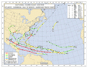
The 2007 Atlantic hurricane season was an active Atlantic hurricane season that produced 17 tropical cyclones, 15 tropical storms, six hurricanes, and two major hurricanes. It officially started on June 1 and ended on November 30, dates which conventionally delimit the...
was an active Atlantic hurricane
Atlantic hurricane
North Atlantic tropical cyclones usually form in the northern hemisphere summer or fall. Tropical cyclones can be categorized by intensity. Tropical storms have one-minute maximum sustained winds of at least 39 mph , while hurricanes have one-minute maximum sustained exceeding 74 mph...
season that produced 17 tropical cyclone
Tropical cyclone
A tropical cyclone is a storm system characterized by a large low-pressure center and numerous thunderstorms that produce strong winds and heavy rain. Tropical cyclones strengthen when water evaporated from the ocean is released as the saturated air rises, resulting in condensation of water vapor...
s. It officially started on June 1 and officially ended on November 30, dates that conventionally delimit the period during which most tropical cyclones form in the Atlantic Ocean
Atlantic Ocean
The Atlantic Ocean is the second-largest of the world's oceanic divisions. With a total area of about , it covers approximately 20% of the Earth's surface and about 26% of its water surface area...
. The first tropical cyclone, Subtropical Storm Andrea
Subtropical Storm Andrea (2007)
Subtropical Storm Andrea was the first named storm and first subtropical cyclone of the 2007 Atlantic hurricane season. It developed out of a previously non-tropical low on May 9 about 150 miles northeast of Daytona Beach, Florida, three weeks before the official start of the season...
developed on May 9, while the last storm, Tropical Storm Olga
Tropical Storm Olga (2007)
Tropical Storm Olga was the fifteenth named storm of the 2007 Atlantic hurricane season. In the second week of December, after the official end of the hurricane season, a low developed east of the northernmost Lesser Antilles. It slowly acquired tropical characteristics, and late on December 10,...
, dissipated on December 13.
During the year, a total of 17 tropical cyclones, 15 tropical storms, 6 hurricanes and 2 major hurricanes formed. The most intense hurricane, Dean
Hurricane Dean
The name Dean was used for five tropical cyclones in the Northern Atlantic Ocean:*1983's Tropical Storm Dean, which struck the coast of Virginia, causing minor erosion and flooding...
, tied for the seventh most intense Atlantic hurricane ever recorded as well as the third most intense Atlantic hurricane at landfall. The season was one of only four on record for the Atlantic
Atlantic Ocean
The Atlantic Ocean is the second-largest of the world's oceanic divisions. With a total area of about , it covers approximately 20% of the Earth's surface and about 26% of its water surface area...
with more than one Category 5 storm. It was the second on record in which an Atlantic hurricane, Felix
Hurricane Felix
The name Felix was used for four tropical cyclones in the Atlantic Ocean.* 1989's Hurricane Felix - A Category 1 storm that dissipated in the Atlantic without threatening land....
, and an eastern Pacific hurricane, Henriette
Hurricane Henriette (2007)
Hurricane Henriette was the deadliest tropical cyclone of the 2007 Pacific hurricane season. The storm, which caused nine fatalities, formed from an area of disturbed weather on August 30, 2007, and became a tropical storm the next day. The cyclone moved parallel to the Mexican Pacific coast, but...
, made landfall on the same day. September had a record-tying eight storms, although the strengths and durations of most of the storms were low. Aside from Dean and Felix, none of the storms exceeded Category 1 intensity.
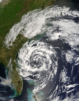
Subtropical Storm Andrea
A large extratropical cycloneExtratropical cyclone
Extratropical cyclones, sometimes called mid-latitude cyclones or wave cyclones, are a group of cyclones defined as synoptic scale low pressure weather systems that occur in the middle latitudes of the Earth having neither tropical nor polar characteristics, and are connected with fronts and...
that formed off the mid-Atlantic
Mid-Atlantic States
The Mid-Atlantic states, also called middle Atlantic states or simply the mid Atlantic, form a region of the United States generally located between New England and the South...
coast on May 6 deepened steadily along a cold front that pushed through Florida
Florida
Florida is a state in the southeastern United States, located on the nation's Atlantic and Gulf coasts. It is bordered to the west by the Gulf of Mexico, to the north by Alabama and Georgia and to the east by the Atlantic Ocean. With a population of 18,801,310 as measured by the 2010 census, it...
. When the system lost most of its baroclinic support, development ceased until its low moved into warmer waters near the Bahamas. However, interaction between the low and a strong high-pressure system to the north generated hurricane-force winds in the system. Decreasing vertical wind shear allowed the storm to generate deeper convection much closer to the center. By May 9 the previously extratropical cyclone
Extratropical cyclone
Extratropical cyclones, sometimes called mid-latitude cyclones or wave cyclones, are a group of cyclones defined as synoptic scale low pressure weather systems that occur in the middle latitudes of the Earth having neither tropical nor polar characteristics, and are connected with fronts and...
had transformed into Subtropical Storm Andrea while located about 140 miles (225 km) southeast of Savannah
Savannah, Georgia
Savannah is the largest city and the county seat of Chatham County, in the U.S. state of Georgia. Established in 1733, the city of Savannah was the colonial capital of the Province of Georgia and later the first state capital of Georgia. Today Savannah is an industrial center and an important...
, Georgia
Georgia (U.S. state)
Georgia is a state located in the southeastern United States. It was established in 1732, the last of the original Thirteen Colonies. The state is named after King George II of Great Britain. Georgia was the fourth state to ratify the United States Constitution, on January 2, 1788...
.
Tropical storm watches were immediately issued for parts of coastal Georgia
Georgia (U.S. state)
Georgia is a state located in the southeastern United States. It was established in 1732, the last of the original Thirteen Colonies. The state is named after King George II of Great Britain. Georgia was the fourth state to ratify the United States Constitution, on January 2, 1788...
and Florida
Florida
Florida is a state in the southeastern United States, located on the nation's Atlantic and Gulf coasts. It is bordered to the west by the Gulf of Mexico, to the north by Alabama and Georgia and to the east by the Atlantic Ocean. With a population of 18,801,310 as measured by the 2010 census, it...
, though all were later dropped. Andrea was the first named storm to form in May since Arlene
Tropical Storm Arlene (1981)
Tropical Storm Arlene was a rare off-season tropical cyclone that hit Cuba and the Bahamas in May 1981. Its formation was unusual, originating from a tropical disturbance that crossed from the eastern Pacific Ocean into the Caribbean Sea; few Atlantic hurricanes develop in this manner...
in 1981
1981 Atlantic hurricane season
The 1981 Atlantic hurricane season officially began on June 1, 1981, and lasted until November 30, 1981. These dates conventionally delimit the period of each year when most tropical cyclones form in the Atlantic basin. The 1981 season was high in activity with 18 tropical depressions and...
, and the first pre-season storm since Ana
Tropical Storm Ana (2003)
Tropical Storm Ana was the only tropical cyclone on record in the Atlantic basin to form during the month of April. The first tropical cyclone of the season, it developed as a subtropical cyclone from a non-tropical low on April 20 to the west of Bermuda...
in April 2003
2003 Atlantic hurricane season
The 2003 Atlantic hurricane season was an active Atlantic hurricane season with tropical activity before and after the official bounds of the season – the first such occurrence in 50 years. The season produced 21 tropical cyclones, of which 16 developed into named storms; seven...
. Andrea began its subtropical phase as it was weakening, and continued this deterioration as it moved southward into an environment with higher wind shear. By May 11, Andrea had lost all significant convection and degenerated into a remnant low. Though it produced intermittent bursts of convection, Andrea's chance of regeneration was extinguished when an advancing cold front pushed it northward and eventually absorbed the system.
The storm produced rough surf and large waves along the coastline from Florida to North Carolina
North Carolina
North Carolina is a state located in the southeastern United States. The state borders South Carolina and Georgia to the south, Tennessee to the west and Virginia to the north. North Carolina contains 100 counties. Its capital is Raleigh, and its largest city is Charlotte...
, causing beach erosion and some damage. No deaths were directly attributable to Andrea, though six people died from the waves generated during its extratropical phase. The storm was also blamed for high winds that could have fueled severe wildfires in northern Florida
Florida
Florida is a state in the southeastern United States, located on the nation's Atlantic and Gulf coasts. It is bordered to the west by the Gulf of Mexico, to the north by Alabama and Georgia and to the east by the Atlantic Ocean. With a population of 18,801,310 as measured by the 2010 census, it...
and southern Georgia
Georgia (U.S. state)
Georgia is a state located in the southeastern United States. It was established in 1732, the last of the original Thirteen Colonies. The state is named after King George II of Great Britain. Georgia was the fourth state to ratify the United States Constitution, on January 2, 1788...
. However, because Andrea never made landfall, most of the resulting damage was associated with large waves, higher than normal tides, associated coastal flooding, and beach erosion caused by the storm.
Tropical Storm Barry
On May 30, a broad low pressure area formed in the Gulf of HondurasGulf of Honduras
The Gulf or Bay of Honduras is a large inlet of the Caribbean Sea, indenting the coasts of Belize, Guatemala, and Honduras. From north to south, it runs for approximately 200 km from Dangriga, Belize, to La Ceiba, Honduras....
. Moving northward, the system slowly deepened as it moved through the northwest Caribbean Sea and into the southeast Gulf of Mexico
Gulf of Mexico
The Gulf of Mexico is a partially landlocked ocean basin largely surrounded by the North American continent and the island of Cuba. It is bounded on the northeast, north and northwest by the Gulf Coast of the United States, on the southwest and south by Mexico, and on the southeast by Cuba. In...
. On June 1, the first day of the officially defined hurricane season, this cyclone organized into Tropical Storm Barry despite being located in an area of high shear, and warnings were immediately issued along the western Florida coastline. Barry provided much-needed precipitation to parts of Florida and Georgia, which were experiencing drought conditions. Barry made landfall near Tampa Bay, Florida on June 2 as a minimal tropical storm. Soon thereafter Barry was downgraded to a tropical depression as it began its extratropical transition. Barry became an extratropical cyclone late in the afternoon of June 2. On June 3, the cyclone moved up the coast of the Carolinas
The Carolinas
The Carolinas is a term used in the United States to refer collectively to the states of North and South Carolina. Together, the two states + have a population of 13,942,126. "Carolina" would be the fifth most populous state behind California, Texas, New York, and Florida...
bringing rains into the Mid-Atlantic states
Mid-Atlantic States
The Mid-Atlantic states, also called middle Atlantic states or simply the mid Atlantic, form a region of the United States generally located between New England and the South...
and New England
New England
New England is a region in the northeastern corner of the United States consisting of the six states of Maine, New Hampshire, Vermont, Massachusetts, Rhode Island, and Connecticut...
. By June 5 its center had moved northward into Atlantic Canada
Atlantic Canada
Atlantic Canada is the region of Canada comprising the four provinces located on the Atlantic coast, excluding Quebec: the three Maritime provinces – New Brunswick, Prince Edward Island, and Nova Scotia – and Newfoundland and Labrador...
.
Tropical Storm Chantal
An area of low pressure developed near the Bahamas on July 28, and slowly organized while moving to the north-northeast. Late on July 30, it was upgraded to a tropical depression, the third of the season, after maintaining deep convection near the center for most of the day.On July 31, the system strengthened into a tropical storm south of Nova Scotia
Nova Scotia
Nova Scotia is one of Canada's three Maritime provinces and is the most populous province in Atlantic Canada. The name of the province is Latin for "New Scotland," but "Nova Scotia" is the recognized, English-language name of the province. The provincial capital is Halifax. Nova Scotia is the...
, the first in nearly two months. However, Chantal became extratropical later that day as it tracked towards Newfoundland over the cooler waters of the north Atlantic.
On August 1, flooding was reported from Placentia
Placentia, Newfoundland and Labrador
Placentia is a town on the Avalon Peninsula, Newfoundland and Labrador, consisting of the amalgamated communities of Jerseyside, Townside, Freshwater, Dunville and Argentia...
to the capital city of St. John's
St. John's, Newfoundland and Labrador
St. John's is the capital and largest city in Newfoundland and Labrador, and is the oldest English-founded city in North America. It is located on the eastern tip of the Avalon Peninsula on the island of Newfoundland. With a population of 192,326 as of July 1, 2010, the St...
, where about 4 inches (101.6 mm) of rain caused the postponement of the annual Royal St. John's Regatta
Royal St. John's Regatta
The Royal St. John's Regatta is North America's oldest annual sporting event with documented proof of 1816 boat races. There is credible contention that St. John's regattas were held even earlier than 1816, likely in the 18th century....
. Up to 6 inches (152.4 mm) of rain fell in the Whitbourne
Whitbourne, Newfoundland and Labrador
Whitbourne is a town on the Avalon Peninsula in Newfoundland and Labrador, Canada in Division No. 1.Whitbourne, Newfoundland’s first inland town, is named after Sir Richard Whitbourne, one of the most colourful early settlers of the province of Newfoundland and Labrador who wrote a book about...
area, according to Environment Canada
Environment Canada
Environment Canada , legally incorporated as the Department of the Environment under the Department of the Environment Act Environment Canada (EC) (French: Environnement Canada), legally incorporated as the Department of the Environment under the Department of the Environment Act Environment...
. The most serious flooding was across the southern Avalon Peninsula
Avalon Peninsula
The Avalon Peninsula is a large peninsula that makes up the southeast portion of the island of Newfoundland.The peninsula is home to 257,223 people, which is approximately 51% of Newfoundland's population in 2009, and is the location of the provincial capital, St. John's. It is connected to the...
, where dozens of roads were washed out, houses were flooded above their basements and several communities were isolated. Ferry service between Argentia
Argentia, Newfoundland and Labrador
Argentia is a community on the island of Newfoundland in the Canadian province of Newfoundland and Labrador. It is situated on a flat headland located along the southwest coast of the Avalon Peninsula on Placentia Bay...
and North Sydney
North Sydney, Nova Scotia
North Sydney is a community in Nova Scotia's Cape Breton Regional Municipality.Located on the north side of Sydney Harbour, along the eastern coast of Cape Breton Island, North Sydney is an important port in Atlantic Canada as it is the western terminus of the Marine Atlantic ferry service...
, Nova Scotia
Nova Scotia
Nova Scotia is one of Canada's three Maritime provinces and is the most populous province in Atlantic Canada. The name of the province is Latin for "New Scotland," but "Nova Scotia" is the recognized, English-language name of the province. The provincial capital is Halifax. Nova Scotia is the...
, was suspended, and one ferry was diverted to Port aux Basques.
States of emergency were declared in at least five communities in the areas surrounding Placentia Bay
Placentia Bay
Placentia Bay is a body of water on the southeast coast of Newfoundland, Canada. It is formed by Burin Peninsula on the west and Avalon Peninsula on the east. Fishing grounds in the bay were used by native people long before the first European fishermen arrived in the 16th century. For a time, the...
and Conception Bay
Conception Bay
Conception Bay is a Canadian bay located on the northeast coast of the island of Newfoundland. The bay indents the Avalon Peninsula with the opening of the bay to the Atlantic Ocean at the northeast. It is bounded by Cape St. Francis in the south and Split Point near Bay de Verde in the north...
, and the Newfoundland and Labrador
Newfoundland and Labrador
Newfoundland and Labrador is the easternmost province of Canada. Situated in the country's Atlantic region, it incorporates the island of Newfoundland and mainland Labrador with a combined area of . As of April 2011, the province's estimated population is 508,400...
Municipal Affairs Minister Jack Byrne
Jack Byrne
Jack Byrne was a Canadian politician. He represented the riding of Cape St. Francis in the Newfoundland and Labrador House of Assembly...
requested a federal disaster area
Disaster area
A disaster area is a region or a locale heavily damaged by either natural hazards, such as tornadoes, hurricanes, tsunamis, floods, earthquakes, technological hazards including nuclear and radiation accidents, or sociological hazards like riots, terrorism or war. The population living there often...
declaration. Damage is estimated to be well into the millions of dollars, with at least $4 million in damage in the town of Placentia alone.
Hurricane Dean
A vigorous tropical wave moved off the west coast of AfricaAfrica
Africa is the world's second largest and second most populous continent, after Asia. At about 30.2 million km² including adjacent islands, it covers 6% of the Earth's total surface area and 20.4% of the total land area...
in the second week of August. It quickly organized itself and formed into a low on August 12. Tropical Depression Four formed on August 13 in the eastern Atlantic from a tropical wave
Tropical wave
Tropical waves, easterly waves, or tropical easterly waves, also known as African easterly waves in the Atlantic region, are a type of atmospheric trough, an elongated area of relatively low air pressure, oriented north to south, which move from east to west across the tropics causing areas of...
to the south of Cape Verde
Cape Verde
The Republic of Cape Verde is an island country, spanning an archipelago of 10 islands located in the central Atlantic Ocean, 570 kilometres off the coast of Western Africa...
. The depression was already exhibiting persistent deep convection, albeit confined to the western portion of its circulation due to easterly wind shear. The depression was expected to strengthen significantly over the following days due to abating wind shear
Wind shear
Wind shear, sometimes referred to as windshear or wind gradient, is a difference in wind speed and direction over a relatively short distance in the atmosphere...
and warming sea surface temperature
Sea surface temperature
Sea surface temperature is the water temperature close to the oceans surface. The exact meaning of surface varies according to the measurement method used, but it is between and below the sea surface. Air masses in the Earth's atmosphere are highly modified by sea surface temperatures within a...
s, which created conditions favorable for tropical intensification
Tropical cyclogenesis
Tropical cyclogenesis is the term that describes the development and strengthening of a tropical cyclone in the atmosphere. The mechanisms through which tropical cyclogenesis occurs are distinctly different from those through which mid-latitude cyclogenesis occurs...
. The depression moved briskly westward, south of a deep layered ridge, quickly escaping the easterly shear.
Based on satellite images and microwave and QuikSCAT
QuikSCAT
The QuikSCAT is an earth-observing satellite that provided estimates of wind speed and direction over the oceans to National Oceanic and Atmospheric Administration and others. This "quick recovery" mission intended to replace the NASA Scatterometer , which failed in June 1997...
data, the depression was upgraded to Tropical Storm Dean on August 14. The storm continued to strengthen overnight as it gained organization, and on August 16 it was upgraded to the first hurricane of the 2007 season.
On August 17 the eye
Eye (cyclone)
The eye is a region of mostly calm weather found at the center of strong tropical cyclones. The eye of a storm is a roughly circular area and typically 30–65 km in diameter. It is surrounded by the eyewall, a ring of towering thunderstorms where the second most severe weather of a cyclone...
of the hurricane passed into the Caribbean
Caribbean
The Caribbean is a crescent-shaped group of islands more than 2,000 miles long separating the Gulf of Mexico and the Caribbean Sea, to the west and south, from the Atlantic Ocean, to the east and north...
between the islands of Martinique
Martinique
Martinique is an island in the eastern Caribbean Sea, with a land area of . Like Guadeloupe, it is an overseas region of France, consisting of a single overseas department. To the northwest lies Dominica, to the south St Lucia, and to the southeast Barbados...
and Saint Lucia
Saint Lucia
Saint Lucia is an island country in the eastern Caribbean Sea on the boundary with the Atlantic Ocean. Part of the Lesser Antilles, it is located north/northeast of the island of Saint Vincent, northwest of Barbados and south of Martinique. It covers a land area of 620 km2 and has an...
as a Category 2 hurricane. In the warm waters of the Caribbean, Dean rapidly strengthened into a Category 5 hurricane with 165 mi/h sustained winds. An eyewall replacement cycle
Eyewall replacement cycle
Eyewall replacement cycles, also called concentric eyewall cycles, naturally occur in intense tropical cyclones, generally with winds greater than 185 km/h , or major hurricanes...
weakened Dean, which then passed just south of Jamaica as a Category 4 hurricane.
Dean regained Category 5 status late on August 20 and at that strength it made landfall on the Yucatán Peninsula
Yucatán Peninsula
The Yucatán Peninsula, in southeastern Mexico, separates the Caribbean Sea from the Gulf of Mexico, with the northern coastline on the Yucatán Channel...
of Mexico
Mexico
The United Mexican States , commonly known as Mexico , is a federal constitutional republic in North America. It is bordered on the north by the United States; on the south and west by the Pacific Ocean; on the southeast by Guatemala, Belize, and the Caribbean Sea; and on the east by the Gulf of...
near Costa Maya
Costa Maya
Costa Maya is a small tourist region in the municipality of Othón P. Blanco in the state of Quintana Roo, Mexico, the only state with Caribbean Sea. This municipality is close to Chetumal on the border with Belize, until recently British Honduras...
on August 21. Dean weakened to a category one storm over land.
At least 42 people have been killed by Hurricane Dean (see Impact of Hurricane Dean). None of these deaths, however, have been attributed to its first landfall, as a Category 5 hurricane, likely because the landfall brought the heaviest storm surges onto sparsely-populated lands north of Chetumal Bay
Chetumal Bay
Chetumal Bay is a large bay in northern Belize and eastern Mexico in the south of the Yucatán Peninsula. On the bay is the major city of Chetumal, in the Mexican state of Quintana Roo. The mouth of the bay is redirected southward and buffered by a large Belizean island named Ambergris Caye. The...
, including the Sian Ka'an Biosphere Reserve.
Tropical Storm Erin
On August 9, an area of convectionConvection
Convection is the movement of molecules within fluids and rheids. It cannot take place in solids, since neither bulk current flows nor significant diffusion can take place in solids....
developed just south of Jamaica
Jamaica
Jamaica is an island nation of the Greater Antilles, in length, up to in width and 10,990 square kilometres in area. It is situated in the Caribbean Sea, about south of Cuba, and west of Hispaniola, the island harbouring the nation-states Haiti and the Dominican Republic...
in association with a trough
Trough (meteorology)
A trough is an elongated region of relatively low atmospheric pressure, often associated with fronts.Unlike fronts, there is not a universal symbol for a trough on a weather chart. The weather charts in some countries or regions mark troughs by a line. In the United States, a trough may be marked...
of low pressure. The system tracked west-northwestward, and by August 10 consisted of a broad surface trough with minimal shower activity. Convection increased on August 11, and by August 12 the interaction between a tropical wave
Tropical wave
Tropical waves, easterly waves, or tropical easterly waves, also known as African easterly waves in the Atlantic region, are a type of atmospheric trough, an elongated area of relatively low air pressure, oriented north to south, which move from east to west across the tropics causing areas of...
and an upper-level low in the area resulted in a large area of disorganized thunderstorms extending from the western Caribbean Sea
Caribbean Sea
The Caribbean Sea is a sea of the Atlantic Ocean located in the tropics of the Western hemisphere. It is bounded by Mexico and Central America to the west and southwest, to the north by the Greater Antilles, and to the east by the Lesser Antilles....
into the central Bahamas. Upper-level winds gradually became more beneficial for development, and on August 13 a broad low pressure area
Low pressure area
A low-pressure area, or "low", is a region where the atmospheric pressure at sea level is below that of surrounding locations. Low-pressure systems form under areas of wind divergence which occur in upper levels of the troposphere. The formation process of a low-pressure area is known as...
formed about 90 miles (145 km) north-northeast of Cancún
Cancún
Cancún is a city of international tourism development certified by the UNWTO . Located on the northeast coast of Quintana Roo in southern Mexico, more than 1,700 km from Mexico City, the Project began operations in 1974 as Integrally Planned Center, a pioneer of FONATUR Cancún is a city of...
, Quintana Roo
Quintana Roo
Quintana Roo officially Estado Libre y Soberano de Quintana Roo is one of the 31 states which, with the Federal District, comprise the 32 Federal Entities of Mexico. It is divided in 10 municipalities and its capital city is Chetumal....
. Late on August 14, a reconnaissance
Hurricane Hunters
The Hurricane Hunters are aircraft that fly into tropical cyclones in the North Atlantic Ocean and Northeastern Pacific Ocean for the specific purpose of directly measuring weather data in and around those storms. In the United States, the Air Force, Navy, and NOAA units have all participated in...
flight into the system reported a small circulation center, but at the time was not well-defined enough to result in the initiation of tropical cyclone advisories. However, deep convection was maintained near the increasingly organizing center, and at 0300 UTC on August 15 the National Hurricane Center
National Hurricane Center
The National Hurricane Center , located at Florida International University in Miami, Florida, is the division of the National Weather Service responsible for tracking and predicting weather systems within the tropics between the Prime Meridian and the 140th meridian west poleward to the 30th...
classified it as Tropical Depression Five about 425 miles (685 km) southeast of Brownsville
Brownsville, Texas
Brownsville is a city in the southernmost tip of the state of Texas, in the United States. It is located on the northern bank of the Rio Grande, directly north and across the border from Matamoros, Tamaulipas, Mexico. Brownsville is the 16th largest city in the state of Texas with a population of...
, Texas
Texas
Texas is the second largest U.S. state by both area and population, and the largest state by area in the contiguous United States.The name, based on the Caddo word "Tejas" meaning "friends" or "allies", was applied by the Spanish to the Caddo themselves and to the region of their settlement in...
.
Based on reconnaissance data received from an NOAA plane investigating the depression, it was upgraded to Tropical Storm Erin on August 15.
It weakened to a tropical depression as it made landfall near Lamar, Texas
Lamar, Texas
Lamar is a small, unincorporated community in Aransas County, Texas , ten miles north of Rockport and forty miles north of Corpus Christi. The community was named for Mirabeau B. Lamar, the second president of the Republic of Texas....
, on August 16, and the NHC issued its last advisory on the system shortly thereafter as it moved inland, and the HPC dropped the system as a tropical depression when it lost its surface wind circulation on the afternoon of August 19.
Two people were killed when a warehouse collapsed in Texas. In total, 16 people died as a result of Erin. Damage was estimated at $25 million.
Hurricane Felix
On August 31, a vigorous tropical wave east of the Windward IslandsWindward Islands
The Windward Islands are the southern islands of the Lesser Antilles, within the West Indies.-Name and geography:The Windward Islands are called such because they were more windward to sailing ships arriving in the New World than the Leeward Islands, given that the prevailing trade winds in the...
was numbered Tropical Depression Six after satellite imagery showed that a tropical low had formed. Early on September 1, it was upgraded to a tropical storm and named Felix. Later that day, Felix was upgraded to a hurricane. On September 2, Felix was upgraded to a major hurricane. It rapidly intensified into a Category 5 storm by the end of the evening, and after briefly weakening to Category 4 status Felix again restrengthened and struck northeastern Nicaragua
Nicaragua
Nicaragua is the largest country in the Central American American isthmus, bordered by Honduras to the north and Costa Rica to the south. The country is situated between 11 and 14 degrees north of the Equator in the Northern Hemisphere, which places it entirely within the tropics. The Pacific Ocean...
with winds of 160 mph (260 km/h) on September 4. (See Impact of Hurricane Felix). It rapidly weakened over land and the last advisory was issued on September 5. At least 133 people were killed by Hurricane Felix with another 70 missing.
Tropical Storm Gabrielle
A cold frontCold front
A cold front is defined as the leading edge of a cooler mass of air, replacing a warmer mass of air.-Development of cold front:The cooler and denser air wedges under the less-dense warmer air, lifting it...
that moved off the southeastern coast of the United States on September 1 developed a weak low over the waters near Georgia
Georgia (U.S. state)
Georgia is a state located in the southeastern United States. It was established in 1732, the last of the original Thirteen Colonies. The state is named after King George II of Great Britain. Georgia was the fourth state to ratify the United States Constitution, on January 2, 1788...
. The low drifted eastward and weakened over the next few days until it joined with convection from an upper-level trough that had been moving over the western Atlantic. On September 8, the center of circulation became sufficiently organized to be declared Subtropical Storm Gabrielle, about 360 nautical miles (666.7 km) southeast of Cape Hatteras
Cape Hatteras
Cape Hatteras is a cape on the coast of North Carolina. It is the point that protrudes the farthest to the southeast along the northeast-to-southwest line of the Atlantic coast of North America...
. For the next twelve hours, the system's strongest winds and thunderstorms remained separated from the center. On September 8 new convection eventually united with the center, leading the transition of Gabrielle into a tropical storm. Gabrielle gradually strengthened as it traveled northwest towards North Carolina
North Carolina
North Carolina is a state located in the southeastern United States. The state borders South Carolina and Georgia to the south, Tennessee to the west and Virginia to the north. North Carolina contains 100 counties. Its capital is Raleigh, and its largest city is Charlotte...
and Virginia
Virginia
The Commonwealth of Virginia , is a U.S. state on the Atlantic Coast of the Southern United States. Virginia is nicknamed the "Old Dominion" and sometimes the "Mother of Presidents" after the eight U.S. presidents born there...
. The storm reached its peak intensity of 60 mph (95 km/h) just before it arrived in Cape Lookout
Cape Lookout (North Carolina)
This article is about the Cape Lookout in North Carolina. See Cape Lookout for other places with a similar name. Cape Lookout is southern point of the Core Banks, one of the natural barrier islands on the Atlantic coast of North Carolina, USA. delimits Onslow Bay to the west from Raleigh Bay to...
, though strong wind shear kept most of the convection and surface winds offshore. Gabrielle weakened over land, and moved back into the Atlantic on September 10. The circulation deteriorated further, and the storm dissipated southwest of Nova Scotia
Nova Scotia
Nova Scotia is one of Canada's three Maritime provinces and is the most populous province in Atlantic Canada. The name of the province is Latin for "New Scotland," but "Nova Scotia" is the recognized, English-language name of the province. The provincial capital is Halifax. Nova Scotia is the...
the next day.
In advance of the storm, tropical cyclone watches and warnings were issued for coastal areas, while rescue teams and the U.S. Coast Guard were put on standby. The storm dropped heavy rainfall near its immediate landfall location but little precipitation elsewhere. Along the coast, high waves, rip current
Rip current
A rip current, commonly referred to by the misnomer rip tide, is a strong channel of water flowing seaward from near the shore, typically through the surf line. Typical flow is at 0.5 metres per second , and can be as fast as 2.5 metres per second...
s, and storm surge
Storm surge
A storm surge is an offshore rise of water associated with a low pressure weather system, typically tropical cyclones and strong extratropical cyclones. Storm surges are caused primarily by high winds pushing on the ocean's surface. The wind causes the water to pile up higher than the ordinary sea...
were reported. Slight localized flooding was reported. Gusty winds also occurred, though no wind damage was reported. Overall damage was minor, and there were no fatalities.
Tropical Storm Ingrid
A large tropical wave exited Africa on September 6 and initially failed to develop due to strong easterly shear. On September 9, a broad low pressure area developed about midway between Africa and the Lesser Antilles. The wind shear slowly weakened, and early on September 12 Tropical Depression Eight developed about 1125 miles (1815 km) east of the Lesser Antilles. The system moved west-northwestward due to a ridge to its north, and with continued wind shear, it remained a tropical depression for 24 hours before convection increased further. Early on September 13 it intensified into Tropical Storm Ingrid, reaching peak winds of 45 mph (75 km/h). Operationally, it was not upgraded to a tropical storm until that evening.Ingrid remained a tropical storm until September 15, when it weakened to a tropical depression due to high shear from a strong tropical upper tropospheric trough
Tropical Upper Tropospheric Trough
A tropical upper tropospheric trough , also known as the mid-oceanic trough, is a trough situated in upper-level tropics. Its formation is usually caused by the intrusion of energy and wind from the mid-latitudes into the tropics. It can also develop from the inverted trough adjacent to an upper...
. Gradual weakening continued as it passed northeast of the Leeward Islands
Leeward Islands
The Leeward Islands are a group of islands in the West Indies. They are the northern islands of the Lesser Antilles chain. As a group they start east of Puerto Rico and reach southward to Dominica. They are situated where the northeastern Caribbean Sea meets the western Atlantic Ocean...
. Ingrid briefly reorganized on September 16, before weakening further and degenerating into an open wave early on September 17. The remnants turned northwestward within the low-level steering flow, and dissipated on September 18 without redevelopment. There were no reports of damage or casualties associated with Ingrid because the storm never threatened land.
Hurricane Humberto
On September 8, a weak surface troughTrough (meteorology)
A trough is an elongated region of relatively low atmospheric pressure, often associated with fronts.Unlike fronts, there is not a universal symbol for a trough on a weather chart. The weather charts in some countries or regions mark troughs by a line. In the United States, a trough may be marked...
and an upper-level
Earth's atmosphere
The atmosphere of Earth is a layer of gases surrounding the planet Earth that is retained by Earth's gravity. The atmosphere protects life on Earth by absorbing ultraviolet solar radiation, warming the surface through heat retention , and reducing temperature extremes between day and night...
low produced disorganized showers and thunderstorms between western Cuba
Cuba
The Republic of Cuba is an island nation in the Caribbean. The nation of Cuba consists of the main island of Cuba, the Isla de la Juventud, and several archipelagos. Havana is the largest city in Cuba and the country's capital. Santiago de Cuba is the second largest city...
and the eastern Gulf of Mexico
Gulf of Mexico
The Gulf of Mexico is a partially landlocked ocean basin largely surrounded by the North American continent and the island of Cuba. It is bounded on the northeast, north and northwest by the Gulf Coast of the United States, on the southwest and south by Mexico, and on the southeast by Cuba. In...
. The area of thunderstorms continued to move west-northwestward across the Gulf of Mexico and on September 12, thunderstorms organized enough to be classified as Tropical Depression Nine about 60 miles (100 km) southeast of Matagorda, Texas
Matagorda, Texas
Matagorda is an unincorporated community in Matagorda County, Texas, United States. It had a population of approximately 710 in 2000. Matagorda is at the end of State Highway 60 and beginning of Farm to Market Road 2031, which runs over the Intracoastal Waterway and south to the Gulf of Mexico...
. The depression quickly intensified, and within three hours of forming, it became Tropical Storm Humberto. Humberto turned to the north and eventually north-northeast and continued to rapidly intensify. In the early morning hours of September 13, a Hurricane Hunter aircraft found that Humberto had strengthened into a hurricane
Atlantic hurricane
North Atlantic tropical cyclones usually form in the northern hemisphere summer or fall. Tropical cyclones can be categorized by intensity. Tropical storms have one-minute maximum sustained winds of at least 39 mph , while hurricanes have one-minute maximum sustained exceeding 74 mph...
while located about 15 miles (20 km) off the coast of Texas
Texas
Texas is the second largest U.S. state by both area and population, and the largest state by area in the contiguous United States.The name, based on the Caddo word "Tejas" meaning "friends" or "allies", was applied by the Spanish to the Caddo themselves and to the region of their settlement in...
. Around 0700 UTC
Coordinated Universal Time
Coordinated Universal Time is the primary time standard by which the world regulates clocks and time. It is one of several closely related successors to Greenwich Mean Time. Computer servers, online services and other entities that rely on having a universally accepted time use UTC for that purpose...
(3 a.m. CDT), Hurricane Humberto made landfall
Landfall (meteorology)
Landfall is the event of a tropical cyclone or a waterspout coming onto land after being over water. When a waterspout makes landfall it is reclassified as a tornado, which can then cause damage inland...
near High Island, Texas
High Island, Texas
High Island is an unincorporated area located in the Bolivar Peninsula census-designated place, Galveston County, Texas, United States. The community is located in the extreme eastern part of the county on Bolivar Peninsula, less than one mile from Chambers County and less than two miles from...
as a category 1 hurricane. Humberto quickly weakened and entered Southwest Louisiana
Louisiana
Louisiana is a state located in the southern region of the United States of America. Its capital is Baton Rouge and largest city is New Orleans. Louisiana is the only state in the U.S. with political subdivisions termed parishes, which are local governments equivalent to counties...
as a tropical storm during the afternoon of September 13.
Hurricane Humberto caused some structural damage on High Island
High Island, Texas
High Island is an unincorporated area located in the Bolivar Peninsula census-designated place, Galveston County, Texas, United States. The community is located in the extreme eastern part of the county on Bolivar Peninsula, less than one mile from Chambers County and less than two miles from...
and widespread tree and power line damage in the Beaumont
Beaumont, Texas
Beaumont is a city in and county seat of Jefferson County, Texas, United States, within the Beaumont–Port Arthur Metropolitan Statistical Area. The city's population was 118,296 at the 2010 census. With Port Arthur and Orange, it forms the Golden Triangle, a major industrial area on the...
-Port Arthur
Port Arthur, Texas
-Demographics:As of the 2000 census, there were 57,755 people, 21,839 households, and 14,675 families residing in the city. The population density was 696.5 people per square mile . There were 24,713 housing units at an average density of 298.0 per square mile...
area. Power outages caused four oil refineries
Oil refinery
An oil refinery or petroleum refinery is an industrial process plant where crude oil is processed and refined into more useful petroleum products, such as gasoline, diesel fuel, asphalt base, heating oil, kerosene, and liquefied petroleum gas...
to halt production in Beaumont
Beaumont, Texas
Beaumont is a city in and county seat of Jefferson County, Texas, United States, within the Beaumont–Port Arthur Metropolitan Statistical Area. The city's population was 118,296 at the 2010 census. With Port Arthur and Orange, it forms the Golden Triangle, a major industrial area on the...
. One person was reported dead as a result of the storm, a Bridge City
Bridge City, Texas
Bridge City is a city in Orange County, Texas, United States. The population was 8,651 at the 2000 census. The town borders the Neches River and Cow Bayou. It is part of the Beaumont–Port Arthur Metropolitan Statistical Area....
man killed when his carport crashed on him outside his house. Damage was estimated at $50 million.
Tropical Depression Ten
A subtropical depressionSubtropical cyclone
A subtropical cyclone is a weather system that has some characteristics of a tropical and an extratropical cyclone. As early as the 1950s, meteorologists were unclear whether they should be characterized as tropical or extratropical cyclones. They were officially recognized by the National...
formed on September 21 in the northeastern Gulf of Mexico
Gulf of Mexico
The Gulf of Mexico is a partially landlocked ocean basin largely surrounded by the North American continent and the island of Cuba. It is bounded on the northeast, north and northwest by the Gulf Coast of the United States, on the southwest and south by Mexico, and on the southeast by Cuba. In...
from the interaction of a tropical wave
Tropical wave
Tropical waves, easterly waves, or tropical easterly waves, also known as African easterly waves in the Atlantic region, are a type of atmospheric trough, an elongated area of relatively low air pressure, oriented north to south, which move from east to west across the tropics causing areas of...
, the tail end of a cold front
Cold front
A cold front is defined as the leading edge of a cooler mass of air, replacing a warmer mass of air.-Development of cold front:The cooler and denser air wedges under the less-dense warmer air, lifting it...
, and an upper-level low
Low pressure area
A low-pressure area, or "low", is a region where the atmospheric pressure at sea level is below that of surrounding locations. Low-pressure systems form under areas of wind divergence which occur in upper levels of the troposphere. The formation process of a low-pressure area is known as...
. Initially containing a poorly-defined circulation and intermittent thunderstorm activity, the system transitioned into a tropical depression after convection
Atmospheric convection
Atmospheric convection is the result of a parcel-environment instability, or temperature difference, layer in the atmosphere. Different lapse rates within dry and moist air lead to instability. Mixing of air during the day which expands the height of the planetary boundary layer leads to...
increased over the center. Tracking northwestward, the depression moved ashore near Fort Walton Beach
Fort Walton Beach, Florida
Fort Walton Beach is a city in southern Okaloosa County, Florida, United States. As of 2005, the population estimate for Fort Walton Beach was 19,992, and as of 2010, the population estimate for Fort Walton Beach is 19,507 recorded by the U.S. Census Bureau...
early on September 22, and shortly thereafter it dissipated over southeastern Alabama
Alabama
Alabama is a state located in the southeastern region of the United States. It is bordered by Tennessee to the north, Georgia to the east, Florida and the Gulf of Mexico to the south, and Mississippi to the west. Alabama ranks 30th in total land area and ranks second in the size of its inland...
.
It was the first tropical cyclone to threaten the New Orleans area after the destructive 2005 hurricane season
2005 Atlantic hurricane season
The 2005 Atlantic hurricane season was the most active Atlantic hurricane season in recorded history, repeatedly shattering numerous records. The impact of the season was widespread and ruinous with an estimated 3,913 deaths and record damage of about $159.2 billion...
and Hurricane Katrina
Hurricane Katrina
Hurricane Katrina of the 2005 Atlantic hurricane season was a powerful Atlantic hurricane. It is the costliest natural disaster, as well as one of the five deadliest hurricanes, in the history of the United States. Among recorded Atlantic hurricanes, it was the sixth strongest overall...
. Overall impact from the cyclone was minor and largely limited to light rainfall. However, the precursor system spawned a damaging tornado in Eustis, Florida
Eustis, Florida
Eustis is a city in Lake County, Florida, United States. The population was 15,106 at the 2000 census. The Census Bureau estimated the population in 2008 to be 19,129. It is part of the Orlando–Kissimmee Metropolitan Statistical Area.-Geography:...
, where 20 houses were destroyed and 30 more were damaged.
Tropical Storm Jerry
The origins of Jerry were from a non-tropical low pressure areaLow pressure area
A low-pressure area, or "low", is a region where the atmospheric pressure at sea level is below that of surrounding locations. Low-pressure systems form under areas of wind divergence which occur in upper levels of the troposphere. The formation process of a low-pressure area is known as...
over the central Atlantic on September 21. The system meandered for two days, gradually developing deeper convection and gaining organization. On September 23, the National Hurricane Center
National Hurricane Center
The National Hurricane Center , located at Florida International University in Miami, Florida, is the division of the National Weather Service responsible for tracking and predicting weather systems within the tropics between the Prime Meridian and the 140th meridian west poleward to the 30th...
declared it a subtropical depression, as a warm core
Eye (cyclone)
The eye is a region of mostly calm weather found at the center of strong tropical cyclones. The eye of a storm is a roughly circular area and typically 30–65 km in diameter. It is surrounded by the eyewall, a ring of towering thunderstorms where the second most severe weather of a cyclone...
had developed but the system was still involved with an upper-level low, and its strongest winds were well removed from the center. Early on September 23, both satellite
Satellite
In the context of spaceflight, a satellite is an object which has been placed into orbit by human endeavour. Such objects are sometimes called artificial satellites to distinguish them from natural satellites such as the Moon....
estimates and QuikScat
QuikSCAT
The QuikSCAT is an earth-observing satellite that provided estimates of wind speed and direction over the oceans to National Oceanic and Atmospheric Administration and others. This "quick recovery" mission intended to replace the NASA Scatterometer , which failed in June 1997...
data determined that the depression had strengthened into Subtropical Storm Jerry, despite the lack of a well-defined inner core.
The storm slowly acquired tropical characteristics including a better-defined warm core, and Jerry became fully tropical that evening as a weak and sheared
Wind shear
Wind shear, sometimes referred to as windshear or wind gradient, is a difference in wind speed and direction over a relatively short distance in the atmosphere...
tropical storm with 40 mph (65 km/h) winds over a small radius. It accelerated northeastward over cooler waters with sea surface temperature
Sea surface temperature
Sea surface temperature is the water temperature close to the oceans surface. The exact meaning of surface varies according to the measurement method used, but it is between and below the sea surface. Air masses in the Earth's atmosphere are highly modified by sea surface temperatures within a...
s below 75°F (24°C). On September 24, it weakened to a tropical depression ahead of a powerful cold front
Cold front
A cold front is defined as the leading edge of a cooler mass of air, replacing a warmer mass of air.-Development of cold front:The cooler and denser air wedges under the less-dense warmer air, lifting it...
with little deep convection remaining in the system. That evening, a QuikScat pass determined that Jerry opened up into a trough
Trough (meteorology)
A trough is an elongated region of relatively low atmospheric pressure, often associated with fronts.Unlike fronts, there is not a universal symbol for a trough on a weather chart. The weather charts in some countries or regions mark troughs by a line. In the United States, a trough may be marked...
, which was being absorbed into the larger frontal system. It completely dissipated by early on September 25. Jerry never approached land during its lifespan, and no damage or casualties were reported.
Hurricane Karen
A very large tropical wave accompanied by a large envelope of low pressure emerged from the coast of AfricaAfrica
Africa is the world's second largest and second most populous continent, after Asia. At about 30.2 million km² including adjacent islands, it covers 6% of the Earth's total surface area and 20.4% of the total land area...
on September 21. As it moved westward, deep convection gradually increased over the disturbance as its broad low-level circulation became better-defined. By September 24, as the system traveled northwestward it organized enough to become a tropical depression. Six hours later the depression was upgraded to Tropical Storm Karen.
Karen's organization and intensity remained steady for the next day. Early on September 26, however, the storm strengthened significantly. In post-operational analysis the cyclone was determined to have reached hurricane-strength for about twelve hours. The strengthening was short-lived because a sharp upper-level trough to the west of Karen increased the amount of vertical wind shear
Wind shear
Wind shear, sometimes referred to as windshear or wind gradient, is a difference in wind speed and direction over a relatively short distance in the atmosphere...
over the hurricane. By September 28 these unfavorable conditions had weakened Karen to a marginal tropical storm and left its low-level circulation exposed. Meanwhile, the storm began heading northward and experiencing intermittent bursts of deep convection. However, the relentless wind shear exposed the system's circulation until it dissipated in the mid-Atlantic on September 29. Karen's remnants lingered near the Leeward Islands
Leeward Islands
The Leeward Islands are a group of islands in the West Indies. They are the northern islands of the Lesser Antilles chain. As a group they start east of Puerto Rico and reach southward to Dominica. They are situated where the northeastern Caribbean Sea meets the western Atlantic Ocean...
for the next few days, although the system never directly affected land. As a result, no reported damages or casualties were associated with Karen.
Hurricane Lorenzo
A tropical waveTropical wave
Tropical waves, easterly waves, or tropical easterly waves, also known as African easterly waves in the Atlantic region, are a type of atmospheric trough, an elongated area of relatively low air pressure, oriented north to south, which move from east to west across the tropics causing areas of...
moved off the western coast of Africa
Africa
Africa is the world's second largest and second most populous continent, after Asia. At about 30.2 million km² including adjacent islands, it covers 6% of the Earth's total surface area and 20.4% of the total land area...
on September 11,
traversed the Caribbean and crossed the Yucatán on September 21. The disturbance developed a small surface low
Low pressure area
A low-pressure area, or "low", is a region where the atmospheric pressure at sea level is below that of surrounding locations. Low-pressure systems form under areas of wind divergence which occur in upper levels of the troposphere. The formation process of a low-pressure area is known as...
on September 24 while moving erratically over the southwestern Gulf of Mexico. Strong upper-level winds
Wind shear
Wind shear, sometimes referred to as windshear or wind gradient, is a difference in wind speed and direction over a relatively short distance in the atmosphere...
initially prevented the system from developing convection; however, the shear relaxed on the following day and convection increased. On the evening of September 25, a Hurricane Hunter
Hurricane Hunters
The Hurricane Hunters are aircraft that fly into tropical cyclones in the North Atlantic Ocean and Northeastern Pacific Ocean for the specific purpose of directly measuring weather data in and around those storms. In the United States, the Air Force, Navy, and NOAA units have all participated in...
aircraft found evidence that the low qualified as a tropical depression. Under weak steering currents, the depression drifted south and southwest, executing a small cyclonic loop into the Bay of Campeche
Bay of Campeche
The Bay of Campeche is the southern bight of the Gulf of Mexico. It is surrounded on three sides by the Mexican states of Campeche, Tabasco and Veracruz. It was named by Francisco Hernández de Córdoba and Antonio de Alaminos during their expedition in 1517...
. Upper-level winds gave way to an anticyclone above the depression, and the system became Tropical Storm Lorenzo on September 27 about 130 nautical miles (240.8 km) east of Tuxpan
Tuxpan
Tuxpan is both a municipality and city located in the Mexican state of Veracruz. The population of the city was 78,523 and of the municipality was 134,394 inhabitants, according to the INEGI census of 2005, residing in a total area of 1,051.89 km²...
. Rapid intensification brought Lorenzo to hurricane status early that evening, less than twelve hours after becoming a tropical storm. Lorenzo reached its peak intensity on September 28, then weakened slightly before making landfall near Tecolutla, Mexico as a minimal hurricane. The small circulation weakened rapidly after landfall, and the system dissipated the next day.
Six deaths in Mexico
Mexico
The United Mexican States , commonly known as Mexico , is a federal constitutional republic in North America. It is bordered on the north by the United States; on the south and west by the Pacific Ocean; on the southeast by Guatemala, Belize, and the Caribbean Sea; and on the east by the Gulf of...
were attributed to Lorenzo, mostly due to flash floods and mudslides. The states of Puebla
Puebla
Puebla officially Estado Libre y Soberano de Puebla is one of the 31 states which, with the Federal District, comprise the 32 Federal Entities of Mexico. It is divided in 217 municipalities and its capital city is Puebla....
and Veracruz
Veracruz
Veracruz, formally Veracruz de Ignacio de la Llave officially Estado Libre y Soberano de Veracruz de Ignacio de la Llave , is one of the 31 states that, along with the Federal District, comprise the 32 federative entities of Mexico. It is divided in 212 municipalities and its capital city is...
reported damage from rain and high winds. Two hundred people were forced to evacuate in Hidalgo when the San Lorenzo River
San Lorenzo River (Mexico)
-References:*Atlas of Mexico, 1975 .*The Prentice Hall American World Atlas, 1984.*Rand McNally, The New International Atlas, 1993....
overflowed its banks. Lorenzo made landfall in virtually the same location that Hurricane Dean had struck a month earlier.
Tropical Storm Melissa
On September 26, a tropical wave exited Africa and quickly developed a low pressure area. Following a convective increase and better-defined outflow, it developed into Tropical Depression Fourteen about 115 miles (185 km) west-southwest of the southernmost Cape Verde Islands early on September 28. Because the depression was isolated from the subtropical ridgeSubtropical ridge
The subtropical ridge is a significant belt of high pressure situated around the latitudes of 30°N in the Northern Hemisphere and 30°S in the Southern Hemisphere. It is characterized by mostly calm winds, which acts to reduce air quality under its axis by causing fog overnight, and haze during...
, the depression drifted west-northwestward. Westerly wind shear prevented significant development, but following an increase in convection, the depression intensified into Tropical Storm Melissa early on September 29. Similar to previous storms Ingrid and Karen
Hurricane Karen (2007)
Hurricane Karen was the eleventh named storm and fourth hurricane of the 2007 Atlantic hurricane season. Karen was a Cape Verde-type hurricane that developed in the eastern tropical Atlantic out of a large tropical wave. The storm briefly reached Category 1 hurricane intensity before slowly...
, high wind shear in the deep tropics hindered Melissa's development, and its peak winds were only 40 mph (65 km/h); operationally, satellite imagery suggested the storm reached 45 mph (72.4 km/h). By September 30, the shear and cooler waters weakened Melissa to a tropical depression with a poorly-defined surface center. The system lost its deep convection and by that afternoon, Melissa degenerated into a remnant low. It continued west-northwestward, producing intermittent convection, until being absorbed by a front northeast of the Lesser Antilles
Lesser Antilles
The Lesser Antilles are a long, partly volcanic island arc in the Western Hemisphere. Most of its islands form the eastern boundary of the Caribbean Sea with the Atlantic Ocean, with the remainder located in the southern Caribbean just north of South America...
on October 5. There were no reports of damage or casualties.
Tropical Depression Fifteen
An area of disturbed weather extended from the northwestern Caribbean SeaCaribbean Sea
The Caribbean Sea is a sea of the Atlantic Ocean located in the tropics of the Western hemisphere. It is bounded by Mexico and Central America to the west and southwest, to the north by the Greater Antilles, and to the east by the Lesser Antilles....
to the western Atlantic Ocean
Atlantic Ocean
The Atlantic Ocean is the second-largest of the world's oceanic divisions. With a total area of about , it covers approximately 20% of the Earth's surface and about 26% of its water surface area...
on October 4, possibly related to the remnants of Hurricane Karen
Hurricane Karen (2007)
Hurricane Karen was the eleventh named storm and fourth hurricane of the 2007 Atlantic hurricane season. Karen was a Cape Verde-type hurricane that developed in the eastern tropical Atlantic out of a large tropical wave. The storm briefly reached Category 1 hurricane intensity before slowly...
. The system slowly organized, developing a surface low pressure
Low pressure area
A low-pressure area, or "low", is a region where the atmospheric pressure at sea level is below that of surrounding locations. Low-pressure systems form under areas of wind divergence which occur in upper levels of the troposphere. The formation process of a low-pressure area is known as...
on October 8 to the northeast of the Turks and Caicos Islands
Turks and Caicos Islands
The Turks and Caicos Islands are a British Overseas Territory and overseas territory of the European Union consisting of two groups of tropical islands in the Caribbean, the larger Caicos Islands and the smaller Turks Islands, known for tourism and as an offshore financial centre.The Turks and...
. Convection
Atmospheric convection
Atmospheric convection is the result of a parcel-environment instability, or temperature difference, layer in the atmosphere. Different lapse rates within dry and moist air lead to instability. Mixing of air during the day which expands the height of the planetary boundary layer leads to...
associated with the storm steadily increased as the low moved towards the northeast. By October 11, the low organized into Tropical Depression Fifteen about 740 mi (1,190 km) east-southeast of Bermuda
Bermuda
Bermuda is a British overseas territory in the North Atlantic Ocean. Located off the east coast of the United States, its nearest landmass is Cape Hatteras, North Carolina, about to the west-northwest. It is about south of Halifax, Nova Scotia, Canada, and northeast of Miami, Florida...
, after the convection had persisted for about 12 hours. An upper-level low to the west caused strong southwesterly wind shear, which inhibited development.
On October 12, a building ridge caused the depression to slow at the same time as the convection began decreasing. The storm's center became exposed as the deep convection became limited to a few small cells north of the center. By that afternoon, the depression degenerated into a remnant low. The remnant low persisted for the next several days while picking up speed and taking a gradual turn towards the northeast. The low transitioned into an extratropical cyclone
Extratropical cyclone
Extratropical cyclones, sometimes called mid-latitude cyclones or wave cyclones, are a group of cyclones defined as synoptic scale low pressure weather systems that occur in the middle latitudes of the Earth having neither tropical nor polar characteristics, and are connected with fronts and...
on October 14 and intensified, moving through the Azores
Azores
The Archipelago of the Azores is composed of nine volcanic islands situated in the middle of the North Atlantic Ocean, and is located about west from Lisbon and about east from the east coast of North America. The islands, and their economic exclusion zone, form the Autonomous Region of the...
with gale force winds. It reached winds of 50 mph (85 km/h) before being absorbed by a larger extratropical storm on October 18.
Hurricane Noel
During the evening of October 27, a low pressure system that had been slowly developing over the eastern Caribbean gained enough organization to be declared Tropical Depression Sixteen. It steadily intensified and became a tropical storm on the afternoon of October 28. It made landfall in HaitiHaiti
Haiti , officially the Republic of Haiti , is a Caribbean country. It occupies the western, smaller portion of the island of Hispaniola, in the Greater Antillean archipelago, which it shares with the Dominican Republic. Ayiti was the indigenous Taíno or Amerindian name for the island...
on October 29, and then meandered across the western Caribbean
Caribbean
The Caribbean is a crescent-shaped group of islands more than 2,000 miles long separating the Gulf of Mexico and the Caribbean Sea, to the west and south, from the Atlantic Ocean, to the east and north...
near Cuba
Cuba
The Republic of Cuba is an island nation in the Caribbean. The nation of Cuba consists of the main island of Cuba, the Isla de la Juventud, and several archipelagos. Havana is the largest city in Cuba and the country's capital. Santiago de Cuba is the second largest city...
for the next three days. Noel brought torrential rain to the region, killing at least 168 people. It then accelerated northeastward, passing through the Bahamas before strengthening to a hurricane on November 1. Noel began an extratropical transition on November 2. While sustained winds were still at Category 1 strength, the NHC issued its final advisory that afternoon. The Canadian Hurricane Centre
Canadian Hurricane Centre
The Canadian Hurricane Centre is a division of the Meteorological Service of Canada, an agency of Canada's Department of the Environment, which exists to advise Canadians on the threat of tropical cyclones such as hurricanes and tropical storms...
issued ongoing advisories every three hours on Post-tropical Storm Noel as it approached Canada's eastern provinces
Atlantic Canada
Atlantic Canada is the region of Canada comprising the four provinces located on the Atlantic coast, excluding Quebec: the three Maritime provinces – New Brunswick, Prince Edward Island, and Nova Scotia – and Newfoundland and Labrador...
until it completed its transition to being fully extratropical on November 4 while over Labrador
Labrador
Labrador is the distinct, northerly region of the Canadian province of Newfoundland and Labrador. It comprises the mainland portion of the province, separated from the island of Newfoundland by the Strait of Belle Isle...
, shortly before it crossed back into the Atlantic, heading towards western Greenland
Greenland
Greenland is an autonomous country within the Kingdom of Denmark, located between the Arctic and Atlantic Oceans, east of the Canadian Arctic Archipelago. Though physiographically a part of the continent of North America, Greenland has been politically and culturally associated with Europe for...
.
Tropical Storm Olga
In the second week of December, after the official end of the hurricane season, a low developed east of the northernmost Lesser AntillesLesser Antilles
The Lesser Antilles are a long, partly volcanic island arc in the Western Hemisphere. Most of its islands form the eastern boundary of the Caribbean Sea with the Atlantic Ocean, with the remainder located in the southern Caribbean just north of South America...
. It slowly acquired tropical characteristics, and late on December 10, the National Hurricane Center declared it Subtropical Storm Olga while just north of Puerto Rico
Puerto Rico
Puerto Rico , officially the Commonwealth of Puerto Rico , is an unincorporated territory of the United States, located in the northeastern Caribbean, east of the Dominican Republic and west of both the United States Virgin Islands and the British Virgin Islands.Puerto Rico comprises an...
. It is the first post-season storm since Tropical Storm Zeta
Tropical Storm Zeta (2005)
Tropical Storm Zeta was a late-developing tropical storm over the central Atlantic which formed after the 2005 Atlantic hurricane season had officially ended , and continued into January 2006...
in the 2005 season
2005 Atlantic hurricane season
The 2005 Atlantic hurricane season was the most active Atlantic hurricane season in recorded history, repeatedly shattering numerous records. The impact of the season was widespread and ruinous with an estimated 3,913 deaths and record damage of about $159.2 billion...
. Olga was only one of a few out of season landfalls, and was the deadliest post-season storm in the Atlantic Basin, with 40 deaths. The storm made landfall on December 11 on the eastern tip of the Dominican Republic
Dominican Republic
The Dominican Republic is a nation on the island of La Hispaniola, part of the Greater Antilles archipelago in the Caribbean region. The western third of the island is occupied by the nation of Haiti, making Hispaniola one of two Caribbean islands that are shared by two countries...
. Later that evening, Olga transitioned into a tropical storm just after making landfall. Olga tracked over Hispaniola
Hispaniola
Hispaniola is a major island in the Caribbean, containing the two sovereign states of the Dominican Republic and Haiti. The island is located between the islands of Cuba to the west and Puerto Rico to the east, within the hurricane belt...
and emerged in the Caribbean Sea
Caribbean Sea
The Caribbean Sea is a sea of the Atlantic Ocean located in the tropics of the Western hemisphere. It is bounded by Mexico and Central America to the west and southwest, to the north by the Greater Antilles, and to the east by the Lesser Antilles....
. Strong wind shear
Wind shear
Wind shear, sometimes referred to as windshear or wind gradient, is a difference in wind speed and direction over a relatively short distance in the atmosphere...
and dry air caused Olga to weaken into a remnant low early on December 13.
The storm impacted many areas affected by Tropical Storm Noel
Hurricane Noel
The name Noel has been used for three tropical cyclones in the Atlantic Ocean.* 1995's Hurricane Noel - reached hurricane strength far from land and was absorbed by a cold front without threatening land....
a month earlier. In Puerto Rico, moderate rainfall caused one death. According to the National Hurricane Center's Tropical Cyclone Report on Olga, at least 22 occurred due to the release of floodgates at a dam in Santiago Province. Two deaths were also reported in Haiti
Haiti
Haiti , officially the Republic of Haiti , is a Caribbean country. It occupies the western, smaller portion of the island of Hispaniola, in the Greater Antillean archipelago, which it shares with the Dominican Republic. Ayiti was the indigenous Taíno or Amerindian name for the island...
, and one fatality was confirmed in Puetro Rico. Almost 12,000 homes were damaged, of which 370 were completely destroyed.
Retirement
Hurricanes DeanHurricane Dean
The name Dean was used for five tropical cyclones in the Northern Atlantic Ocean:*1983's Tropical Storm Dean, which struck the coast of Virginia, causing minor erosion and flooding...
, Felix
Hurricane Felix
The name Felix was used for four tropical cyclones in the Atlantic Ocean.* 1989's Hurricane Felix - A Category 1 storm that dissipated in the Atlantic without threatening land....
, and Noel
Hurricane Noel
The name Noel has been used for three tropical cyclones in the Atlantic Ocean.* 1995's Hurricane Noel - reached hurricane strength far from land and was absorbed by a cold front without threatening land....
were retired by the World Meteorological Organization
World Meteorological Organization
The World Meteorological Organization is an intergovernmental organization with a membership of 189 Member States and Territories. It originated from the International Meteorological Organization , which was founded in 1873...
on May 13, 2008 at the 30th Session of the World Meteorological Organization's Regional Association IV Hurricane Committee during its annual meeting in Orlando
Orlando, Florida
Orlando is a city in the central region of the U.S. state of Florida. It is the county seat of Orange County, and the center of the Greater Orlando metropolitan area. According to the 2010 US Census, the city had a population of 238,300, making Orlando the 79th largest city in the United States...
, Florida
Florida
Florida is a state in the southeastern United States, located on the nation's Atlantic and Gulf coasts. It is bordered to the west by the Gulf of Mexico, to the north by Alabama and Georgia and to the east by the Atlantic Ocean. With a population of 18,801,310 as measured by the 2010 census, it...
. The names were replaced with Dorian, Fernand, and Nestor.
See also
- List of Atlantic hurricanes
- List of storms in the 2006 Atlantic hurricane season