

Leeward Islands
Encyclopedia
Lesser Antilles
The Lesser Antilles are a long, partly volcanic island arc in the Western Hemisphere. Most of its islands form the eastern boundary of the Caribbean Sea with the Atlantic Ocean, with the remainder located in the southern Caribbean just north of South America...
chain. As a group they start east of Puerto Rico
Puerto Rico
Puerto Rico , officially the Commonwealth of Puerto Rico , is an unincorporated territory of the United States, located in the northeastern Caribbean, east of the Dominican Republic and west of both the United States Virgin Islands and the British Virgin Islands.Puerto Rico comprises an...
and reach southward to Dominica
Dominica
Dominica , officially the Commonwealth of Dominica, is an island nation in the Lesser Antilles region of the Caribbean Sea, south-southeast of Guadeloupe and northwest of Martinique. Its size is and the highest point in the country is Morne Diablotins, which has an elevation of . The Commonwealth...
. They are situated where the northeastern Caribbean Sea
Caribbean Sea
The Caribbean Sea is a sea of the Atlantic Ocean located in the tropics of the Western hemisphere. It is bounded by Mexico and Central America to the west and southwest, to the north by the Greater Antilles, and to the east by the Lesser Antilles....
meets the western Atlantic Ocean
Atlantic Ocean
The Atlantic Ocean is the second-largest of the world's oceanic divisions. With a total area of about , it covers approximately 20% of the Earth's surface and about 26% of its water surface area...
. The more southerly part of the Lesser Antilles chain is called the Windward Islands
Windward Islands
The Windward Islands are the southern islands of the Lesser Antilles, within the West Indies.-Name and geography:The Windward Islands are called such because they were more windward to sailing ships arriving in the New World than the Leeward Islands, given that the prevailing trade winds in the...
.
Explanation of name
These islands are referred to as "leeward" because the prevailing winds in the area blow from the east-north-east (ENE). (see trade windTrade wind
The trade winds are the prevailing pattern of easterly surface winds found in the tropics, within the lower portion of the Earth's atmosphere, in the lower section of the troposphere near the Earth's equator...
). Thus these islands are downwind from, or leeward of, the southeasternmost Windward Islands
Windward Islands
The Windward Islands are the southern islands of the Lesser Antilles, within the West Indies.-Name and geography:The Windward Islands are called such because they were more windward to sailing ships arriving in the New World than the Leeward Islands, given that the prevailing trade winds in the...
, the group of islands that first meet the trade wind
Trade wind
The trade winds are the prevailing pattern of easterly surface winds found in the tropics, within the lower portion of the Earth's atmosphere, in the lower section of the troposphere near the Earth's equator...
s.
Geography
The Leeward Islands fall under a number of national administrations.There is some active volcanism
Volcanism
Volcanism is the phenomenon connected with volcanoes and volcanic activity. It includes all phenomena resulting from and causing magma within the crust or mantle of a planet to rise through the crust and form volcanic rocks on the surface....
within the islands, with a notable eruption in Montserrat
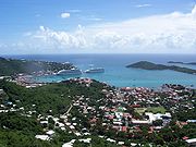
Montserrat
Montserrat is a British overseas territory located in the Leeward Islands, part of the chain of islands called the Lesser Antilles in the West Indies. This island measures approximately long and wide, giving of coastline...
in the recent past.
History
Anciently, the islands were inhabited by the Carib people, who gave their name to the CaribbeanCaribbean
The Caribbean is a crescent-shaped group of islands more than 2,000 miles long separating the Gulf of Mexico and the Caribbean Sea, to the west and south, from the Atlantic Ocean, to the east and north...
, and the Taíno people
Taíno people
The Taínos were pre-Columbian inhabitants of the Bahamas, Greater Antilles, and the northern Lesser Antilles. It is thought that the seafaring Taínos are relatives of the Arawak people of South America...
. Some descendants of these groups still survive in the islands.
The islands were amongst the first parts of the Americas to fall under the control of Spanish Empire
Spanish Empire
The Spanish Empire comprised territories and colonies administered directly by Spain in Europe, in America, Africa, Asia and Oceania. It originated during the Age of Exploration and was therefore one of the first global empires. At the time of Habsburgs, Spain reached the peak of its world power....
. European contact commenced with Christopher Columbus' second voyage, and many of the islands' names originate from this period, e.g. Montserrat was named for Santa Maria de Montserrate, after the Blessed Virgin of the Monastery of Montserrat, which is located on the Mountain of Montserrat, the national shrine of Catalonia
Catalonia
Catalonia is an autonomous community in northeastern Spain, with the official status of a "nationality" of Spain. Catalonia comprises four provinces: Barcelona, Girona, Lleida, and Tarragona. Its capital and largest city is Barcelona. Catalonia covers an area of 32,114 km² and has an...
.
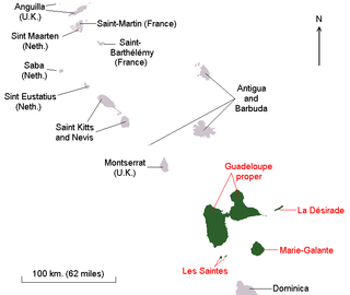
List of the Leeward Islands


- Puerto Rican Virgin IslandsSpanish Virgin IslandsThe Spanish Virgin Islands, formerly called the Passage Islands and also known as the Puerto Rican Virgin Islands, are part of the Commonwealth of Puerto Rico, located east of the main island of Puerto Rico. Puerto Rican tourist literature uses the name Spanish Virgin Islands, but most general...
: ViequesVieques, Puerto RicoVieques , in full Isla de Vieques, is an island–municipality of Puerto Rico in the northeastern Caribbean, part of an island grouping sometimes known as the Spanish Virgin Islands...
, CulebraCulebra, Puerto RicoIsla Culebra is an island-municipality of Puerto Rico originally called Isla Pasaje and Isla de San Ildefonso. It is located approximately east of the Puerto Rican mainland, west of St. Thomas and north of Vieques. Culebra is spread over 5 wards and Culebra Pueblo... - U.S. Virgin Islands: St. ThomasSaint Thomas, U.S. Virgin IslandsSaint Thomas is an island in the Caribbean Sea and with the islands of Saint John, Saint Croix, and Water Island a county and constituent district of the United States Virgin Islands , an unincorporated territory of the United States. Located on the island is the territorial capital and port of...
, St. JohnSaint John, U.S. Virgin IslandsSaint John is an island in the Caribbean Sea and a constituent district of the United States Virgin Islands , an unincorporated territory of the United States. St...
, St. Croix, Water IslandWater Island, U.S. Virgin IslandsWater Island was acquired by the USA in 1917 from Denmark but continued to be owned by a corporation until several decades later. Since 1996, it has formed part of the U.S. Virgin Islands, a United States territory located in the Caribbean Sea. The island is of volcanic origin and lies to the...
(U.S.) - British Virgin IslandsBritish Virgin IslandsThe Virgin Islands, often called the British Virgin Islands , is a British overseas territory and overseas territory of the European Union, located in the Caribbean to the east of Puerto Rico. The islands make up part of the Virgin Islands archipelago, the remaining islands constituting the U.S...
: Jost Van DykeJost Van DykeAt roughly 8 square kilometers, and about 3 square miles Jost Van Dyke is the smallest of the four main islands of the British Virgin Islands, the northern portion of the archipelago of the Virgin Islands, located in the Atlantic Ocean and Caribbean Sea. Jost Van Dyke lies about 8 km to the...
, TortolaTortolaTortola is the largest and most populated of the British Virgin Islands, a group of islands that form part of the archipelago of the Virgin Islands. Local tradition recounts that Christopher Columbus named it Tortola, meaning "land of the Turtle Dove". Columbus named the island Santa Ana...
, Virgin GordaVirgin GordaVirgin Gorda is the third-largest and second most populous of the British Virgin Islands . Located at approximately 18 degrees, 48 minutes North, and 64 degrees, 30 minutes West, it covers an area of about...
, AnegadaAnegadaAnegada is the northernmost of the British Virgin Islands, a group of islands which form part of the archipelago of the Virgin Islands. It lies approximately north of Virgin Gorda. Anegada is the only inhabited British Virgin Island formed from coral and limestone, rather than being of volcanic...
(U.K.) - AnguillaAnguillaAnguilla is a British overseas territory and overseas territory of the European Union in the Caribbean. It is one of the most northerly of the Leeward Islands in the Lesser Antilles, lying east of Puerto Rico and the Virgin Islands and directly north of Saint Martin...
(U.K.) - Saint Martin/Sint MaartenSaint MartinSaint Martin is an island in the northeast Caribbean, approximately east of Puerto Rico. The 87 km2 island is divided roughly 60/40 between France and the Kingdom of the Netherlands ; however, the Dutch side has the larger population. It is one of the smallest sea islands divided between...
(Fr./Neth.) - Saint-Barthélemy (Fr.)
- Saba (Neth.)
- Sint Eustatius (Neth.)
- Saint KittsSaint KittsSaint Kitts Saint Kitts Saint Kitts (also known more formally as Saint Christopher Island (Saint-Christophe in French) is an island in the West Indies. The west side of the island borders the Caribbean Sea, and the eastern coast faces the Atlantic Ocean...
- NevisNevisNevis is an island in the Caribbean Sea, located near the northern end of the Lesser Antilles archipelago, about 350 km east-southeast of Puerto Rico and 80 km west of Antigua. The 93 km² island is part of the inner arc of the Leeward Islands chain of the West Indies...
- BarbudaBarbudaBarbuda is an island in the Eastern Caribbean, and forms part of the state of Antigua and Barbuda. It has a population of about 1,500, most of whom live in the town of Codrington.-Location:...
- AntiguaAntiguaAntigua , also known as Waladli, is an island in the West Indies, in the Leeward Islands in the Caribbean region, the main island of the country of Antigua and Barbuda. Antigua means "ancient" in Spanish and was named by Christopher Columbus after an icon in Seville Cathedral, Santa Maria de la...
- RedondaRedondaRedonda is a very small, uninhabited Caribbean island which is part of Antigua and Barbuda, in the Leeward Islands, West Indies.This small island lies southwest of Antigua, in the waters between the islands of Nevis and Montserrat...
(uninhabited) - MontserratMontserratMontserrat is a British overseas territory located in the Leeward Islands, part of the chain of islands called the Lesser Antilles in the West Indies. This island measures approximately long and wide, giving of coastline...
(U.K.) - GuadeloupeGuadeloupeGuadeloupe is an archipelago located in the Leeward Islands, in the Lesser Antilles, with a land area of 1,628 square kilometres and a population of 400,000. It is the first overseas region of France, consisting of a single overseas department. As with the other overseas departments, Guadeloupe...
(Fr.) - DominicaDominicaDominica , officially the Commonwealth of Dominica, is an island nation in the Lesser Antilles region of the Caribbean Sea, south-southeast of Guadeloupe and northwest of Martinique. Its size is and the highest point in the country is Morne Diablotins, which has an elevation of . The Commonwealth...
(sometimes included)
The small and remote Isla Aves
Isla Aves
Isla de Aves , or Aves Island, is a Caribbean dependency of Venezuela. It has been the subject of numerous territorial disputes between the neighboring independent islands, such as Dominica, and European mother countries of surrounding dependent islands, such as the Netherlands. It lies to the west...
may perhaps be included with this group for convenience.
See also
- AntillesAntillesThe Antilles islands form the greater part of the West Indies in the Caribbean Sea. The Antilles are divided into two major groups: the "Greater Antilles" to the north and west, including the larger islands of Cuba, Jamaica, Hispaniola , and Puerto Rico; and the smaller "Lesser Antilles" on the...
- Leeward AntillesLeeward AntillesThe Leeward Antilles are a chain of islands in the Caribbean – specifically, the southerly islands of the Lesser Antilles along the southeastern fringe of the Caribbean Sea, just north of the Venezuelan coast of the South American mainland...
- British Leeward IslandsBritish Leeward IslandsThe British Leeward Islands was a British colony existing between 1833 and 1960, and consisting of Antigua, Barbuda, the British Virgin Islands, Montserrat, Saint Kitts, Nevis, Anguilla and Dominica....
- Leeward Islands cricket teamLeeward Islands cricket teamThe Leeward Islands cricket team is a first class cricket team representing the member countries of the Leeward Islands Cricket Association, a regional association which again is part of the West Indies Cricket Board. Contrary to the normal English definition of the Leeward Islands, Dominica is not...
External links
- The Leeward Islands Gazette, with full page images and full searchable text is freely and openly available in the Digital Library of the CaribbeanDigital Library of the CaribbeanThe Digital Library of the Caribbean is an international digital library operated collaboratively by the contributing partners.-Partners:...
- Antigua, Montserrat and Virgin Islands Gazette, with full page images and full searchable text is freely and openly available in the Digital Library of the CaribbeanDigital Library of the CaribbeanThe Digital Library of the Caribbean is an international digital library operated collaboratively by the contributing partners.-Partners:...