
.gif)
Eye (cyclone)
Encyclopedia
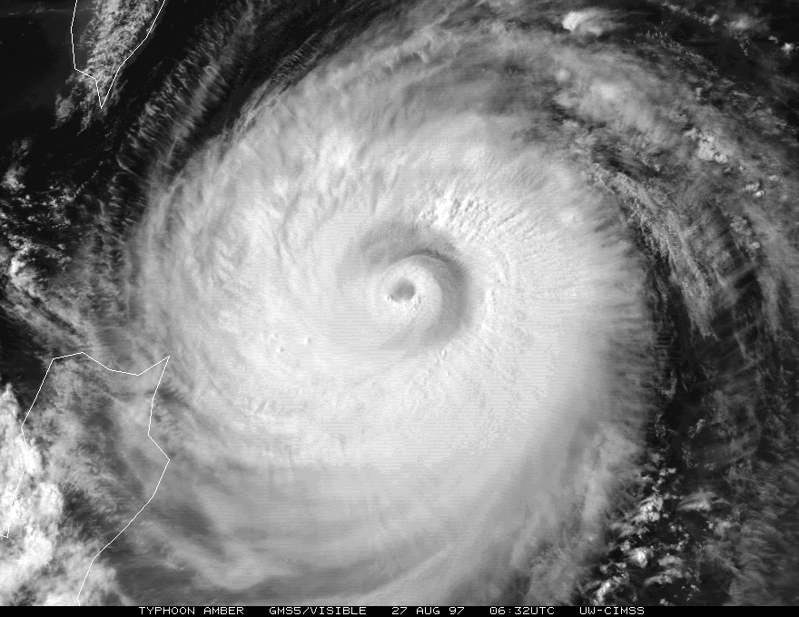
The eye is a region of mostly calm weather
found at the center of strong tropical cyclone
s. The eye of a storm
is a roughly circular area and typically 30–65 km (20–40 miles) in diameter
. It is surrounded by the eyewall, a ring of towering thunderstorm
s where the second most severe weather of a cyclone occurs. The cyclone's lowest barometric pressure occurs in the eye, and can be as much as 15% lower than the atmospheric pressure
outside the storm.
In strong tropical cyclones, the eye is characterized by light wind
s and clear skies, surrounded on all sides by a towering, symmetric eyewall. In weaker tropical cyclones, the eye is less well-defined, and can be covered by the central dense overcast, which is an area of high, thick cloud
s that show up brightly on satellite imagery
. Weaker or disorganized storms may also feature an eyewall that does not completely encircle the eye, or have an eye that features heavy rain. In all storms, however, the eye is the location of the storm's minimum barometric pressure: the area where the atmospheric pressure at sea level is the lowest.
While normally quite symmetric, eyes can be oblong and irregular, especially in weakening storms. A large ragged eye is a non-circular eye which appears fragmented, and is an indicator of a weak or weakening tropical cyclone. An open eye is an eye which can be circular, but the eyewall does not completely encircle the eye, also indicating a weakening, moisture-deprived cyclone. Both of these observations are used to estimate the intensity of tropical cyclones via Dvorak analysis
. Eyewalls are typically circular; however, distinctly polygonal shapes ranging from triangles to hexagons occasionally occur.
While typical mature storms have eyes that are a few dozen miles across, rapidly intensifying
storms can develop an extremely small, clear, and circular eye, sometimes referred to as a pinhole eye. Storms with pinhole eyes are prone to large fluctuations in intensity, and provide difficulties and frustrations for forecasters.
Small eyes—those less than 10 nmi
(19 km, 12 mi) across—often trigger eyewall replacement cycles, where a new eyewall begins to form outside the original eyewall. This can take place anywhere from ten to a few hundred miles (fifteen to hundreds of kilometers) outside the inner eye. The storm then develops two concentric eyewalls, or an "eye within an eye". In most cases, the outer eyewall begins to contract soon after its formation, which chokes off the inner eye and leaves a much larger but more stable eye. While the replacement cycle tends to weaken storms as it occurs, the new eyewall can contract fairly quickly after the old eyewall dissipates, allowing the storm to re-strengthen. This may trigger another cycle of eyewall replacement.
Eyes can range in size from 320 km (198.8 mi) (Typhoon Carmen) to a mere 3 km (1.9 mi) (Hurricane Wilma
) across. While it is uncommon for storms with large eyes to become very intense, it does occur, especially in annular hurricane
s. Hurricane Isabel
was the eleventh most powerful Atlantic hurricane
in recorded history, and sustained a large, 65–80 km (40–50 mi)-wide eye for a period of several days.

 Tropical cyclones typically form from large, disorganized areas of disturbed weather in tropical regions
. As more thunderstorms form and gather, the storm develops rainbands which start rotating around a common center. As the storm gains strength, a ring of stronger convection forms at a certain distance from the rotational center of the developing storm. Since stronger thunderstorms and heavier rain mark areas of stronger updrafts, the barometric pressure at the surface begins to drop, and air begins to build up in the upper levels of the cyclone. This results in the formation of an upper level anticyclone
, or an area of high atmospheric pressure above the central dense overcast. Consequently, most of this built up air flows outward anticyclonically above the tropical cyclone. Outside the forming eye, the anticyclone at the upper levels of the atmosphere enhances the flow towards the center of the cyclone, pushing air towards the eyewall and causing a positive feedback loop.
However, a small portion of the built-up air, instead of flowing outward, flows inward towards the center of the storm. This causes air pressure to build even further, to the point where the weight of the air counteracts the strength of the updrafts in the center of the storm. Air begins to descend in the center of the storm, creating a mostly rain-free area; a newly formed eye.
There are many aspects of this process which remain a mystery. Scientists do not know why a ring of convection forms around the center of circulation instead of on top of it, or why the upper-level anticyclone only ejects a portion of the excess air above the storm. Many theories exist as to the exact process by which the eye forms: all that is known for sure is that the eye is necessary for tropical cyclones to achieve high wind speeds.
The formation of an eye is almost always an indicator of increasing tropical cyclone organisation and strength. Because of this, forecasters watch developing storms closely for signs of eye formation.
For storms with a clear eye, detection of the eye is as simple as looking at pictures from a weather satellite
. However, for storms with a filled eye, or an eye completely covered by the central dense overcast, other detection methods must be used. Observations from ships and Hurricane Hunters
can pinpoint an eye visually, by looking for a drop in wind speed or lack of rainfall in the storm's center. In the United States, South Korea, and a few other countries, a network of NEXRAD
Doppler weather radar stations can detect eyes near the coast. Weather satellites also carry equipment for measuring atmospheric water vapor and cloud temperatures, which can be used to spot a forming eye. In addition, scientists have recently discovered that the amount of ozone
in the eye is much higher than the amount in the eyewall, due to air sinking from the ozone-rich stratosphere. Instruments sensitive to ozone perform measurements, which are used to observe rising and sinking columns of air, and provide indication of the formation of an eye, even before satellite imagery
can determine its formation.
s, generally with winds greater than 185 km/h (115 mph), or major hurricanes (Category 3
or above). When tropical cyclones reach this intensity, and the eyewall contracts or is already sufficiently small (see above), some of the outer rainbands may strengthen and organize into a ring of thunderstorms—an outer eyewall—that slowly moves inward and robs the inner eyewall of its needed moisture and angular momentum
. Since the strongest winds are located in a cyclone's eyewall, the tropical cyclone usually weakens during this phase, as the inner wall is "choked" by the outer wall. Eventually the outer eyewall replaces the inner one completely, and the storm can re-intensify.
The discovery of this process was partially responsible for the end of the U.S. government's hurricane modification experiment Project Stormfury
. This project set out to seed clouds
outside the eyewall, causing a new eyewall to form and weakening the storm. When it was discovered that this was a natural process due to hurricane dynamics, the project was quickly abandoned.
Almost every intense hurricane undergoes at least one of these cycles during its existence. Hurricane Allen
in 1980 went through repeated eyewall replacement cycles, fluctuating between Category 5 and Category 3 status on the Saffir-Simpson Scale several times. Hurricane Juliette
was a rare documented case of triple eyewalls.
-dominated flow. The moat between eyewalls is just one example of a rapid filamentation zone, or an area in the storm where the rotational speed of the air changes greatly in proportion to the distance from the storm's center. Such strain-dominated regions can potentially be found near any vortex
of sufficient strength, but are most pronounced in strong tropical cyclones.
. In these vortices, wind speed can be up to 10% higher than in the rest of the eyewall. Eyewall mesovortices are most common during periods of intensification in tropical cyclones.
Eyewall mesovortices often exhibit unusual behavior in tropical cyclones. They usually rotate around the low pressure center, but sometimes they remain stationary. Eyewall mesovortices have even been documented to cross the eye of a storm. These phenomena have been documented observationally, experimentally, and theoretically.
Eyewall mesovortices are a significant factor in the formation of tornado
es after tropical cyclone landfall. Mesovortices can spawn rotation in individual thunderstorms (a mesocyclone
), which leads to tornadic activity. At landfall, friction is generated between the circulation of the tropical cyclone and land. This can allow the mesovortices to descend to the surface, causing large outbreaks of tornadoes.
 The stadium effect is a phenomenon observed in strong tropical cyclones. It is a fairly common event, where the clouds of the eyewall curve outward from the surface with height. This gives the eye an appearance resembling an open dome from the air, akin to a sports stadium
. An eye is always larger at the top of the storm, and smallest at the bottom of the storm because the rising air in the eyewall follows isolines
of equal angular momentum
, which also slope outward with height. This phenomenon refers to the characteristics of tropical cyclones with very small eyes, where the sloping phenomenon is much more pronounced.
in which convection
is absent. These eye-like features are most normally found in intensifying tropical storms and hurricanes of Category 1 strength on the Saffir-Simpson Scale. For example, an eye-like feature was found in Hurricane Beta when the storm had maximum wind speed
s of 50 mph. These eye-like features are typically not visible on visible wavelengths or infrared wavelengths from space, however, they are easily seen on microwave
satellite imagery. The development of this feature at middle levels of the atmosphere is similar to the formation of the complete eye, but its position might be horizontally displaced due to vertical wind shear.
, when it was a category four hurricane, estimated that waves near the eyewall were in excess of 40 meters (130 ft) from peak to trough.
A common mistake, especially in areas where hurricanes are uncommon, is for residents to wander outside to inspect the damage while the eye passes over, thinking the storm is over. They are then caught completely by surprise by the violent winds in the opposite eyewall. The National Weather Service
strongly discourages leaving shelter while the eye passes over.
s are mesoscale
weather systems (typically smaller than 1,000 km or 600 miles (965.6 km) across) found near the poles
. Like tropical cyclones, they form over relatively warm water, can feature deep convection (thunderstorms), and feature winds of gale force
(51 km/h, 32 mph) or greater. Unlike storms of tropical nature, however, they thrive in much colder temperatures and at much higher latitude
s. They are also smaller and last for shorter durations (few last longer than a day or so). Despite these differences, they can be very similar in structure to tropical cyclones, featuring a clear eye surrounded by an eyewall and rain/snow bands.
 Extratropical storms
are areas of low pressure which exist at the boundary of different air mass
es. Almost all storms found at mid-latitudes are extratropical in nature, including classic North American nor'easter
s and European windstorms. The most severe of these can have a clear "eye" at the site of lowest barometric pressure, though it is usually surrounded by lower, non-convective clouds and is found near the back end of the storm.
are cyclones which have some extratropical characteristics and some tropical characteristics. As such, they may have an eye, but are not true tropical storms. Subtropical storms can be very hazardous, with high winds and seas, and often evolve into true tropical storms. As such, the National Hurricane Center
began including subtropical storms in its naming scheme in 2002.
es are destructive, small-scale storms, which produce the fastest winds on earth. There are two main types—single-vortex tornadoes, which consist of a single spinning column of air, and multiple-vortex tornadoes, which consist of small suction vortices, resembling mini-tornadoes themselves, all rotating around a common center. Both of these types of tornadoes are theorized to have calm centers, referred to by some meteorologists as "eyes". These theories are supported by doppler velocity observations by weather radar and eyewitness accounts.
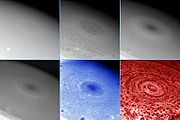
reported in November 2006 that the Cassini spacecraft observed a 'hurricane
-like' storm locked to the south pole of Saturn
that had a clearly defined eyewall. This observation is particularly notable because eyewall clouds had not previously been seen on any planet other than Earth (including a failure to observe an eyewall in the Great Red Spot of Jupiter by the Galileo spacecraft). In 2007, very large vortices http://www.esa.int/esa-mmg/mmg.pl?b=b&type=I&mission=Venus%20Express&single=y&start=5 on both poles of Venus
were observed by the Venus Express
mission of the European Space Agency
to have a dipole eye structure.
Weather
Weather is the state of the atmosphere, to the degree that it is hot or cold, wet or dry, calm or stormy, clear or cloudy. Most weather phenomena occur in the troposphere, just below the stratosphere. Weather refers, generally, to day-to-day temperature and precipitation activity, whereas climate...
found at the center of strong tropical cyclone
Tropical cyclone
A tropical cyclone is a storm system characterized by a large low-pressure center and numerous thunderstorms that produce strong winds and heavy rain. Tropical cyclones strengthen when water evaporated from the ocean is released as the saturated air rises, resulting in condensation of water vapor...
s. The eye of a storm
Storm
A storm is any disturbed state of an astronomical body's atmosphere, especially affecting its surface, and strongly implying severe weather...
is a roughly circular area and typically 30–65 km (20–40 miles) in diameter
Diameter
In geometry, a diameter of a circle is any straight line segment that passes through the center of the circle and whose endpoints are on the circle. The diameters are the longest chords of the circle...
. It is surrounded by the eyewall, a ring of towering thunderstorm
Thunderstorm
A thunderstorm, also known as an electrical storm, a lightning storm, thundershower or simply a storm is a form of weather characterized by the presence of lightning and its acoustic effect on the Earth's atmosphere known as thunder. The meteorologically assigned cloud type associated with the...
s where the second most severe weather of a cyclone occurs. The cyclone's lowest barometric pressure occurs in the eye, and can be as much as 15% lower than the atmospheric pressure
Atmospheric pressure
Atmospheric pressure is the force per unit area exerted into a surface by the weight of air above that surface in the atmosphere of Earth . In most circumstances atmospheric pressure is closely approximated by the hydrostatic pressure caused by the weight of air above the measurement point...
outside the storm.
In strong tropical cyclones, the eye is characterized by light wind
Wind
Wind is the flow of gases on a large scale. On Earth, wind consists of the bulk movement of air. In outer space, solar wind is the movement of gases or charged particles from the sun through space, while planetary wind is the outgassing of light chemical elements from a planet's atmosphere into space...
s and clear skies, surrounded on all sides by a towering, symmetric eyewall. In weaker tropical cyclones, the eye is less well-defined, and can be covered by the central dense overcast, which is an area of high, thick cloud
Cloud
A cloud is a visible mass of liquid droplets or frozen crystals made of water and/or various chemicals suspended in the atmosphere above the surface of a planetary body. They are also known as aerosols. Clouds in Earth's atmosphere are studied in the cloud physics branch of meteorology...
s that show up brightly on satellite imagery
Satellite imagery
Satellite imagery consists of photographs of Earth or other planets made by means of artificial satellites.- History :The first images from space were taken on sub-orbital flights. The U.S-launched V-2 flight on October 24, 1946 took one image every 1.5 seconds...
. Weaker or disorganized storms may also feature an eyewall that does not completely encircle the eye, or have an eye that features heavy rain. In all storms, however, the eye is the location of the storm's minimum barometric pressure: the area where the atmospheric pressure at sea level is the lowest.
Structure
A typical tropical cyclone will have an eye of approximately 30–65 km (20–40 mi) across, usually situated at the geometric center of the storm. The eye may be clear or have spotty low clouds (a clear eye), it may be filled with low- and mid-level clouds (a filled eye), or it may be obscured by the central dense overcast. There is, however, very little wind and rain, especially near the center. This is in stark contrast to conditions in the eyewall, which contains the storm's strongest winds. Due to the mechanics of a tropical cyclone, the eye and the air directly above it are warmer than their surroundings.While normally quite symmetric, eyes can be oblong and irregular, especially in weakening storms. A large ragged eye is a non-circular eye which appears fragmented, and is an indicator of a weak or weakening tropical cyclone. An open eye is an eye which can be circular, but the eyewall does not completely encircle the eye, also indicating a weakening, moisture-deprived cyclone. Both of these observations are used to estimate the intensity of tropical cyclones via Dvorak analysis
Dvorak technique
The Dvorak technique is a widely used system to subjectively estimate tropical cyclone intensity based solely on visible and infrared satellite images. Several agencies issue Dvorak intensity numbers for cyclones of sufficient intensity...
. Eyewalls are typically circular; however, distinctly polygonal shapes ranging from triangles to hexagons occasionally occur.
While typical mature storms have eyes that are a few dozen miles across, rapidly intensifying
Rapid deepening
Rapid deepening, also known as rapid intensification, is a meteorological condition that occurs when the minimum sea-level atmospheric pressure of a tropical cyclone decreases drastically in a short period of time. The National Weather Service describes rapid deepening as a decrease of...
storms can develop an extremely small, clear, and circular eye, sometimes referred to as a pinhole eye. Storms with pinhole eyes are prone to large fluctuations in intensity, and provide difficulties and frustrations for forecasters.
Small eyes—those less than 10 nmi
Nautical mile
The nautical mile is a unit of length that is about one minute of arc of latitude along any meridian, but is approximately one minute of arc of longitude only at the equator...
(19 km, 12 mi) across—often trigger eyewall replacement cycles, where a new eyewall begins to form outside the original eyewall. This can take place anywhere from ten to a few hundred miles (fifteen to hundreds of kilometers) outside the inner eye. The storm then develops two concentric eyewalls, or an "eye within an eye". In most cases, the outer eyewall begins to contract soon after its formation, which chokes off the inner eye and leaves a much larger but more stable eye. While the replacement cycle tends to weaken storms as it occurs, the new eyewall can contract fairly quickly after the old eyewall dissipates, allowing the storm to re-strengthen. This may trigger another cycle of eyewall replacement.
Eyes can range in size from 320 km (198.8 mi) (Typhoon Carmen) to a mere 3 km (1.9 mi) (Hurricane Wilma
Hurricane Wilma
Hurricane Wilma was the most intense tropical cyclone ever recorded in the Atlantic basin. Wilma was the twenty-second storm , thirteenth hurricane, sixth major hurricane, and fourth Category 5 hurricane of the record-breaking 2005 season...
) across. While it is uncommon for storms with large eyes to become very intense, it does occur, especially in annular hurricane
Annular hurricane
An annular hurricane, also known as a truck tire or doughnut hurricane, is a tropical cyclone in the Atlantic or Eastern Pacific Oceans that features a large, symmetric eye surrounded by a thick ring of intense convection. This type of storm is not prone to the fluctuations in intensity associated...
s. Hurricane Isabel
Hurricane Isabel
Hurricane Isabel was the costliest and deadliest hurricane in the 2003 Atlantic hurricane season. The ninth named storm, fifth hurricane, and second major hurricane of the season, Isabel formed near the Cape Verde Islands from a tropical wave on September 6 in the tropical Atlantic Ocean...
was the eleventh most powerful Atlantic hurricane
Atlantic hurricane
North Atlantic tropical cyclones usually form in the northern hemisphere summer or fall. Tropical cyclones can be categorized by intensity. Tropical storms have one-minute maximum sustained winds of at least 39 mph , while hurricanes have one-minute maximum sustained exceeding 74 mph...
in recorded history, and sustained a large, 65–80 km (40–50 mi)-wide eye for a period of several days.
Formation and detection
Tropics
The tropics is a region of the Earth surrounding the Equator. It is limited in latitude by the Tropic of Cancer in the northern hemisphere at approximately N and the Tropic of Capricorn in the southern hemisphere at S; these latitudes correspond to the axial tilt of the Earth...
. As more thunderstorms form and gather, the storm develops rainbands which start rotating around a common center. As the storm gains strength, a ring of stronger convection forms at a certain distance from the rotational center of the developing storm. Since stronger thunderstorms and heavier rain mark areas of stronger updrafts, the barometric pressure at the surface begins to drop, and air begins to build up in the upper levels of the cyclone. This results in the formation of an upper level anticyclone
Anticyclone
An anticyclone is a weather phenomenon defined by the United States' National Weather Service's glossary as "[a] large-scale circulation of winds around a central region of high atmospheric pressure, clockwise in the Northern Hemisphere, counterclockwise in the Southern Hemisphere"...
, or an area of high atmospheric pressure above the central dense overcast. Consequently, most of this built up air flows outward anticyclonically above the tropical cyclone. Outside the forming eye, the anticyclone at the upper levels of the atmosphere enhances the flow towards the center of the cyclone, pushing air towards the eyewall and causing a positive feedback loop.
However, a small portion of the built-up air, instead of flowing outward, flows inward towards the center of the storm. This causes air pressure to build even further, to the point where the weight of the air counteracts the strength of the updrafts in the center of the storm. Air begins to descend in the center of the storm, creating a mostly rain-free area; a newly formed eye.
There are many aspects of this process which remain a mystery. Scientists do not know why a ring of convection forms around the center of circulation instead of on top of it, or why the upper-level anticyclone only ejects a portion of the excess air above the storm. Many theories exist as to the exact process by which the eye forms: all that is known for sure is that the eye is necessary for tropical cyclones to achieve high wind speeds.
The formation of an eye is almost always an indicator of increasing tropical cyclone organisation and strength. Because of this, forecasters watch developing storms closely for signs of eye formation.
For storms with a clear eye, detection of the eye is as simple as looking at pictures from a weather satellite
Weather satellite
The weather satellite is a type of satellite that is primarily used to monitor the weather and climate of the Earth. Satellites can be either polar orbiting, seeing the same swath of the Earth every 12 hours, or geostationary, hovering over the same spot on Earth by orbiting over the equator while...
. However, for storms with a filled eye, or an eye completely covered by the central dense overcast, other detection methods must be used. Observations from ships and Hurricane Hunters
Hurricane Hunters
The Hurricane Hunters are aircraft that fly into tropical cyclones in the North Atlantic Ocean and Northeastern Pacific Ocean for the specific purpose of directly measuring weather data in and around those storms. In the United States, the Air Force, Navy, and NOAA units have all participated in...
can pinpoint an eye visually, by looking for a drop in wind speed or lack of rainfall in the storm's center. In the United States, South Korea, and a few other countries, a network of NEXRAD
NEXRAD
NEXRAD or Nexrad is a network of 159 high-resolution Doppler weather radars operated by the National Weather Service, an agency of the National Oceanic and Atmospheric Administration within the United States Department of Commerce...
Doppler weather radar stations can detect eyes near the coast. Weather satellites also carry equipment for measuring atmospheric water vapor and cloud temperatures, which can be used to spot a forming eye. In addition, scientists have recently discovered that the amount of ozone
Ozone
Ozone , or trioxygen, is a triatomic molecule, consisting of three oxygen atoms. It is an allotrope of oxygen that is much less stable than the diatomic allotrope...
in the eye is much higher than the amount in the eyewall, due to air sinking from the ozone-rich stratosphere. Instruments sensitive to ozone perform measurements, which are used to observe rising and sinking columns of air, and provide indication of the formation of an eye, even before satellite imagery
Satellite imagery
Satellite imagery consists of photographs of Earth or other planets made by means of artificial satellites.- History :The first images from space were taken on sub-orbital flights. The U.S-launched V-2 flight on October 24, 1946 took one image every 1.5 seconds...
can determine its formation.
Associated phenomena
Eyewall replacement cycles
Eyewall replacement cycles, also called concentric eyewall cycles, naturally occur in intense tropical cycloneTropical cyclone
A tropical cyclone is a storm system characterized by a large low-pressure center and numerous thunderstorms that produce strong winds and heavy rain. Tropical cyclones strengthen when water evaporated from the ocean is released as the saturated air rises, resulting in condensation of water vapor...
s, generally with winds greater than 185 km/h (115 mph), or major hurricanes (Category 3
Saffir-Simpson Hurricane Scale
The Saffir–Simpson Hurricane Scale , or the Saffir–Simpson Hurricane Wind Scale , classifies hurricanes — Western Hemisphere tropical cyclones that exceed the intensities of tropical depressions and tropical storms — into five categories distinguished by the intensities of their sustained winds...
or above). When tropical cyclones reach this intensity, and the eyewall contracts or is already sufficiently small (see above), some of the outer rainbands may strengthen and organize into a ring of thunderstorms—an outer eyewall—that slowly moves inward and robs the inner eyewall of its needed moisture and angular momentum
Angular momentum
In physics, angular momentum, moment of momentum, or rotational momentum is a conserved vector quantity that can be used to describe the overall state of a physical system...
. Since the strongest winds are located in a cyclone's eyewall, the tropical cyclone usually weakens during this phase, as the inner wall is "choked" by the outer wall. Eventually the outer eyewall replaces the inner one completely, and the storm can re-intensify.
The discovery of this process was partially responsible for the end of the U.S. government's hurricane modification experiment Project Stormfury
Project Stormfury
Project Stormfury was an attempt to weaken tropical cyclones by flying aircraft into them and seeding with silver iodide. The project was run by the United States Government from 1962 to 1983....
. This project set out to seed clouds
Cloud seeding
Cloud seeding, a form of intentional weather modification, is the attempt to change the amount or type of precipitation that falls from clouds, by dispersing substances into the air that serve as cloud condensation or ice nuclei, which alter the microphysical processes within the cloud...
outside the eyewall, causing a new eyewall to form and weakening the storm. When it was discovered that this was a natural process due to hurricane dynamics, the project was quickly abandoned.
Almost every intense hurricane undergoes at least one of these cycles during its existence. Hurricane Allen
Hurricane Allen
Hurricane Allen was the first and strongest hurricane of the 1980 Atlantic hurricane season. It was one of the strongest hurricanes in recorded history, one of the few hurricanes to reach Category 5 status on the Saffir-Simpson Hurricane Scale on three separate occasions, and spent more time...
in 1980 went through repeated eyewall replacement cycles, fluctuating between Category 5 and Category 3 status on the Saffir-Simpson Scale several times. Hurricane Juliette
Hurricane Juliette (2001)
Hurricane Juliette was a long lasting Category 4 hurricane in the 2001 Pacific hurricane season. It caused 12 deaths and $400 million in damage when it hit Baja California in late September.-Meteorological history:...
was a rare documented case of triple eyewalls.
Moats
A moat in a tropical cyclone is a clear ring outside the eyewall, or between concentric eyewalls, characterized by slowly sinking air, little or no precipitation, and strainStrain (materials science)
In continuum mechanics, the infinitesimal strain theory, sometimes called small deformation theory, small displacement theory, or small displacement-gradient theory, deals with infinitesimal deformations of a continuum body...
-dominated flow. The moat between eyewalls is just one example of a rapid filamentation zone, or an area in the storm where the rotational speed of the air changes greatly in proportion to the distance from the storm's center. Such strain-dominated regions can potentially be found near any vortex
Vortex
A vortex is a spinning, often turbulent,flow of fluid. Any spiral motion with closed streamlines is vortex flow. The motion of the fluid swirling rapidly around a center is called a vortex...
of sufficient strength, but are most pronounced in strong tropical cyclones.
Eyewall mesovortices
Eyewall mesovortices are small scale rotational features found in the eyewalls of intense tropical cyclones. They are similar, in principle, to small "suction vortices" often observed in multiple-vortex tornadoesMultiple vortex tornado
A multiple-vortex tornado is a tornado that contains several vortices rotating around, inside of, and as part of the main vortex. These multiple vortices are somewhat similar to eyewall mesovortices found in intense tropical cyclones...
. In these vortices, wind speed can be up to 10% higher than in the rest of the eyewall. Eyewall mesovortices are most common during periods of intensification in tropical cyclones.
Eyewall mesovortices often exhibit unusual behavior in tropical cyclones. They usually rotate around the low pressure center, but sometimes they remain stationary. Eyewall mesovortices have even been documented to cross the eye of a storm. These phenomena have been documented observationally, experimentally, and theoretically.
Eyewall mesovortices are a significant factor in the formation of tornado
Tornado
A tornado is a violent, dangerous, rotating column of air that is in contact with both the surface of the earth and a cumulonimbus cloud or, in rare cases, the base of a cumulus cloud. They are often referred to as a twister or a cyclone, although the word cyclone is used in meteorology in a wider...
es after tropical cyclone landfall. Mesovortices can spawn rotation in individual thunderstorms (a mesocyclone
Mesocyclone
A mesocyclone is a vortex of air, approximately 2 to 10 miles in diameter , within a convective storm....
), which leads to tornadic activity. At landfall, friction is generated between the circulation of the tropical cyclone and land. This can allow the mesovortices to descend to the surface, causing large outbreaks of tornadoes.
Stadium effect
Stadium
A modern stadium is a place or venue for outdoor sports, concerts, or other events and consists of a field or stage either partly or completely surrounded by a structure designed to allow spectators to stand or sit and view the event.)Pausanias noted that for about half a century the only event...
. An eye is always larger at the top of the storm, and smallest at the bottom of the storm because the rising air in the eyewall follows isolines
Contour line
A contour line of a function of two variables is a curve along which the function has a constant value. In cartography, a contour line joins points of equal elevation above a given level, such as mean sea level...
of equal angular momentum
Angular momentum
In physics, angular momentum, moment of momentum, or rotational momentum is a conserved vector quantity that can be used to describe the overall state of a physical system...
, which also slope outward with height. This phenomenon refers to the characteristics of tropical cyclones with very small eyes, where the sloping phenomenon is much more pronounced.
Eye-like features
An eye-like structure is often found in intensifying tropical cyclones. Similar to the eye seen in hurricanes or typhoons, it is a circular area at the circulation center of the stormStorm
A storm is any disturbed state of an astronomical body's atmosphere, especially affecting its surface, and strongly implying severe weather...
in which convection
Convection
Convection is the movement of molecules within fluids and rheids. It cannot take place in solids, since neither bulk current flows nor significant diffusion can take place in solids....
is absent. These eye-like features are most normally found in intensifying tropical storms and hurricanes of Category 1 strength on the Saffir-Simpson Scale. For example, an eye-like feature was found in Hurricane Beta when the storm had maximum wind speed
Wind speed
Wind speed, or wind velocity, is a fundamental atmospheric rate.Wind speed affects weather forecasting, aircraft and maritime operations, construction projects, growth and metabolism rate of many plant species, and countless other implications....
s of 50 mph. These eye-like features are typically not visible on visible wavelengths or infrared wavelengths from space, however, they are easily seen on microwave
Microwave
Microwaves, a subset of radio waves, have wavelengths ranging from as long as one meter to as short as one millimeter, or equivalently, with frequencies between 300 MHz and 300 GHz. This broad definition includes both UHF and EHF , and various sources use different boundaries...
satellite imagery. The development of this feature at middle levels of the atmosphere is similar to the formation of the complete eye, but its position might be horizontally displaced due to vertical wind shear.
Hazards
Though the eye is by far the calmest part of the storm, with no wind at the center and typically clear skies, over the ocean it is possibly the most hazardous area. In the eyewall, wind-driven waves are all traveling in the same direction. In the center of the eye, however, waves from all directions converge, creating erratic crests which can build on each other, creating rogue waves. The maximum height of hurricane waves is unknown, but measurements of Hurricane IvanHurricane Ivan
Hurricane Ivan was a large, long-lived, Cape Verde-type hurricane that caused widespread damage in the Caribbean and United States. The cyclone was the ninth named storm, the sixth hurricane and the fourth major hurricane of the active 2004 Atlantic hurricane season...
, when it was a category four hurricane, estimated that waves near the eyewall were in excess of 40 meters (130 ft) from peak to trough.
A common mistake, especially in areas where hurricanes are uncommon, is for residents to wander outside to inspect the damage while the eye passes over, thinking the storm is over. They are then caught completely by surprise by the violent winds in the opposite eyewall. The National Weather Service
National Weather Service
The National Weather Service , once known as the Weather Bureau, is one of the six scientific agencies that make up the National Oceanic and Atmospheric Administration of the United States government...
strongly discourages leaving shelter while the eye passes over.
Other storms
Though only tropical cyclones have structures which are officially called "eyes", there are other storms which can exhibit eye-like structures:Polar lows
Polar lowPolar low
A polar low is a small-scale, long-lived atmospheric low pressure system that is found over the ocean areas poleward of the main polar front in both the Northern and Southern Hemispheres. The systems usually have a horizontal length scale of less than and exist for no more than a couple of days. ...
s are mesoscale
Mesoscale meteorology
Mesoscale meteorology is the study of weather systems smaller than synoptic scale systems but larger than microscale and storm-scale cumulus systems. Horizontal dimensions generally range from around 5 kilometers to several hundred kilometers...
weather systems (typically smaller than 1,000 km or 600 miles (965.6 km) across) found near the poles
Geographical pole
A geographical pole is either of the two points—the north pole and the south pole—on the surface of a rotating planet where the axis of rotation meets the surface of the body...
. Like tropical cyclones, they form over relatively warm water, can feature deep convection (thunderstorms), and feature winds of gale force
Beaufort scale
The Beaufort Scale is an empirical measure that relates wind speed to observed conditions at sea or on land. Its full name is the Beaufort Wind Force Scale.-History:...
(51 km/h, 32 mph) or greater. Unlike storms of tropical nature, however, they thrive in much colder temperatures and at much higher latitude
Latitude
In geography, the latitude of a location on the Earth is the angular distance of that location south or north of the Equator. The latitude is an angle, and is usually measured in degrees . The equator has a latitude of 0°, the North pole has a latitude of 90° north , and the South pole has a...
s. They are also smaller and last for shorter durations (few last longer than a day or so). Despite these differences, they can be very similar in structure to tropical cyclones, featuring a clear eye surrounded by an eyewall and rain/snow bands.
Extratropical storms
Extratropical cyclone
Extratropical cyclones, sometimes called mid-latitude cyclones or wave cyclones, are a group of cyclones defined as synoptic scale low pressure weather systems that occur in the middle latitudes of the Earth having neither tropical nor polar characteristics, and are connected with fronts and...
are areas of low pressure which exist at the boundary of different air mass
Air mass
In meteorology, an air mass is a volume of air defined by its temperature and water vapor content. Air masses cover many hundreds or thousands of square miles, and adopt the characteristics of the surface below them. They are classified according to latitude and their continental or maritime...
es. Almost all storms found at mid-latitudes are extratropical in nature, including classic North American nor'easter
Nor'easter
A nor'easter is a type of macro-scale storm along the East Coast of the United States and Atlantic Canada, so named because the storm travels to the northeast from the south and the winds come from the northeast, especially in the coastal areas of the Northeastern United States and Atlantic Canada...
s and European windstorms. The most severe of these can have a clear "eye" at the site of lowest barometric pressure, though it is usually surrounded by lower, non-convective clouds and is found near the back end of the storm.
Subtropical storms
Subtropical stormsSubtropical cyclone
A subtropical cyclone is a weather system that has some characteristics of a tropical and an extratropical cyclone. As early as the 1950s, meteorologists were unclear whether they should be characterized as tropical or extratropical cyclones. They were officially recognized by the National...
are cyclones which have some extratropical characteristics and some tropical characteristics. As such, they may have an eye, but are not true tropical storms. Subtropical storms can be very hazardous, with high winds and seas, and often evolve into true tropical storms. As such, the National Hurricane Center
National Hurricane Center
The National Hurricane Center , located at Florida International University in Miami, Florida, is the division of the National Weather Service responsible for tracking and predicting weather systems within the tropics between the Prime Meridian and the 140th meridian west poleward to the 30th...
began including subtropical storms in its naming scheme in 2002.
Tornadoes
TornadoTornado
A tornado is a violent, dangerous, rotating column of air that is in contact with both the surface of the earth and a cumulonimbus cloud or, in rare cases, the base of a cumulus cloud. They are often referred to as a twister or a cyclone, although the word cyclone is used in meteorology in a wider...
es are destructive, small-scale storms, which produce the fastest winds on earth. There are two main types—single-vortex tornadoes, which consist of a single spinning column of air, and multiple-vortex tornadoes, which consist of small suction vortices, resembling mini-tornadoes themselves, all rotating around a common center. Both of these types of tornadoes are theorized to have calm centers, referred to by some meteorologists as "eyes". These theories are supported by doppler velocity observations by weather radar and eyewitness accounts.
Extraterrestrial storms
NASANASA
The National Aeronautics and Space Administration is the agency of the United States government that is responsible for the nation's civilian space program and for aeronautics and aerospace research...
reported in November 2006 that the Cassini spacecraft observed a 'hurricane
Tropical cyclone
A tropical cyclone is a storm system characterized by a large low-pressure center and numerous thunderstorms that produce strong winds and heavy rain. Tropical cyclones strengthen when water evaporated from the ocean is released as the saturated air rises, resulting in condensation of water vapor...
-like' storm locked to the south pole of Saturn
Saturn
Saturn is the sixth planet from the Sun and the second largest planet in the Solar System, after Jupiter. Saturn is named after the Roman god Saturn, equated to the Greek Cronus , the Babylonian Ninurta and the Hindu Shani. Saturn's astronomical symbol represents the Roman god's sickle.Saturn,...
that had a clearly defined eyewall. This observation is particularly notable because eyewall clouds had not previously been seen on any planet other than Earth (including a failure to observe an eyewall in the Great Red Spot of Jupiter by the Galileo spacecraft). In 2007, very large vortices http://www.esa.int/esa-mmg/mmg.pl?b=b&type=I&mission=Venus%20Express&single=y&start=5 on both poles of Venus
Venus
Venus is the second planet from the Sun, orbiting it every 224.7 Earth days. The planet is named after Venus, the Roman goddess of love and beauty. After the Moon, it is the brightest natural object in the night sky, reaching an apparent magnitude of −4.6, bright enough to cast shadows...
were observed by the Venus Express
Venus Express
Venus Express is the first Venus exploration mission of the European Space Agency. Launched in November 2005, it arrived at Venus in April 2006 and has been continuously sending back science data from its polar orbit around Venus. Equipped with seven science instruments, the main objective of the...
mission of the European Space Agency
European Space Agency
The European Space Agency , established in 1975, is an intergovernmental organisation dedicated to the exploration of space, currently with 18 member states...
to have a dipole eye structure.
See also
- List of tropical cyclones
- Radius of maximum windRadius of maximum windThe radius of maximum wind is the distance between the center of a cyclone and its band of strongest winds. It is a parameter in atmospheric dynamics and tropical cyclone forecasting. The highest rainfall rates occur near the RMW of tropical cyclones. The extent of a cyclone's storm surge and...
- Storm surgeStorm surgeA storm surge is an offshore rise of water associated with a low pressure weather system, typically tropical cyclones and strong extratropical cyclones. Storm surges are caused primarily by high winds pushing on the ocean's surface. The wind causes the water to pile up higher than the ordinary sea...
- Tropical cycloneTropical cycloneA tropical cyclone is a storm system characterized by a large low-pressure center and numerous thunderstorms that produce strong winds and heavy rain. Tropical cyclones strengthen when water evaporated from the ocean is released as the saturated air rises, resulting in condensation of water vapor...