

Gulf of Honduras
Encyclopedia
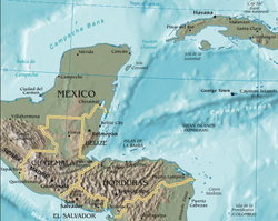
Caribbean Sea
The Caribbean Sea is a sea of the Atlantic Ocean located in the tropics of the Western hemisphere. It is bounded by Mexico and Central America to the west and southwest, to the north by the Greater Antilles, and to the east by the Lesser Antilles....
, indenting the coasts of Belize
Belize
Belize is a constitutional monarchy and the northernmost country in Central America. Belize has a diverse society, comprising many cultures and languages. Even though Kriol and Spanish are spoken among the population, Belize is the only country in Central America where English is the official...
, Guatemala
Guatemala
Guatemala is a country in Central America bordered by Mexico to the north and west, the Pacific Ocean to the southwest, Belize to the northeast, the Caribbean to the east, and Honduras and El Salvador to the southeast...
, and Honduras
Honduras
Honduras is a republic in Central America. It was previously known as Spanish Honduras to differentiate it from British Honduras, which became the modern-day state of Belize...
. From north to south, it runs for approximately 200 km from Dangriga
Dangriga
Dangriga, formerly known as Stann Creek Town, is a town in southern Belize, located on the Caribbean coast at the mouth of Stann Creek. It is the capital of Belize's Stann Creek District and also the largest town in southern Belize...
, Belize, to La Ceiba
La Ceiba
La Ceiba is a port city on the northern coast of Honduras in Central America. It is located on the southern edge of the Caribbean, forming part of the south eastern boundary of the Gulf of Honduras...
, Honduras.
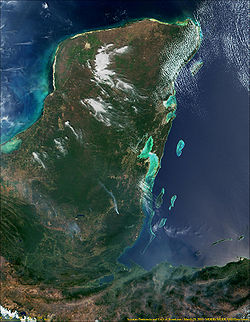
The inner Gulf of Honduras is lined by the Belize Barrier Reef
Belize Barrier Reef
The Belize Barrier Reef is a series of coral reefs straddling the coast of Belize, roughly offshore in the north and in the south within the country limits...
which forms the southern part of the 900 km long Mesoamerican Barrier Reef System
Mesoamerican Barrier Reef System
The Mesoamerican Barrier Reef System stretches over 1000 km from Isla Contoy at the tip of the Yucatán Peninsula down to the Bay Islands of Honduras...
, the second-largest coral reef system in the world. The Belize Barrier Reef includes a number of small islands, called cay
Cay
A cay , also spelled caye or key, is a small, low-elevation, sandy island formed on the surface of coral reefs. Cays occur in tropical environments throughout the Pacific, Atlantic and Indian Oceans , where they provide habitable and agricultural land for hundreds of thousands of people...
s, and collectively known as the Pelican Cays.
The Gulf of Honduras is marked by complex dynamics of coastal and open waters, and ocean currents, which have produced a very diverse and unique ecosystem with a wide variety of coastal marine waters, including coastline estuaries, barrier beaches, lagoon
Lagoon
A lagoon is a body of shallow sea water or brackish water separated from the sea by some form of barrier. The EU's habitat directive defines lagoons as "expanses of shallow coastal salt water, of varying salinity or water volume, wholly or partially separated from the sea by sand banks or shingle,...
s, intertidal salt marshes, mangrove forests, seagrass
Seagrass
Seagrasses are flowering plants from one of four plant families , all in the order Alismatales , which grow in marine, fully saline environments.-Ecology:...
beds, keys and barrier reefs.
The gulf receives the runoff from the watersheds of 12 rivers with an estimated discharge of 1232 m³ s-1. These rivers include the Moho
Moho River
-References:*Rand McNally, The New International Atlas, 1993.* Biodiversity & Environmental Data System of Belize....
, Sarstún
Sarstoon River
Sarstoon River is a river in the Toledo District of Belize. It forms the country's southern boundary with Guatemala.The river's sources are located in neighbouring Guatemala, where it is known by its Spanish name, Río Sarstún. It flows through the Guatemalan departments of Alta Verapaz and Izabal...
, Río Dulce, Motagua
Motagua River
The Motagua River is a long river in Guatemala. It rises in the western highlands of Guatemala where it is also called Río Grande, and runs in an easterly direction to the Gulf of Honduras. The final few kilometres of the river form part of the Guatemala/Honduras border...
, and Ulúa
Ulúa River
The Ulua River is a river in western Honduras. It rises in the central mountainous area of the country close to La Paz and runs 150 miles approximately due northwards to the east end of the Gulf of Honduras at . En route, it is joined by the Sulaco River, the Otoro River and the Chamelecon River....
. Increased volumes of sediments drained in the Gulf of Honduras pose a threat to its marine ecosystem
Marine ecosystem
Marine ecosystems are among the largest of Earth's aquatic ecosystems. They include oceans, salt marsh and intertidal ecology, estuaries and lagoons, mangroves and coral reefs, the deep sea and the sea floor. They can be contrasted with freshwater ecosystems, which have a lower salt content. Marine...
.
Many American
United States
The United States of America is a federal constitutional republic comprising fifty states and a federal district...
anglers
Fishing
Fishing is the activity of trying to catch wild fish. Fish are normally caught in the wild. Techniques for catching fish include hand gathering, spearing, netting, angling and trapping....
visit the Gulf of Honduras to catch the marlin
Marlin
Marlin, family Istiophoridae, are fish with an elongated body, a spear-like snout or bill, and a long rigid dorsal fin, which extends forward to form a crest. Its common name is thought to derive from its resemblance to a sailor's marlinspike...
that abound there. Tourists
Tourism
Tourism is travel for recreational, leisure or business purposes. The World Tourism Organization defines tourists as people "traveling to and staying in places outside their usual environment for not more than one consecutive year for leisure, business and other purposes".Tourism has become a...
are often taken on boat trips to the Pelican Cays, notably Caye Caulker
Caye Caulker
Caye Caulker is a small limestone coral island off the coast of Belize in the Caribbean Sea measuring about by less than . The town on the island is known by the name Caye Caulker Village...
and Ambergris Caye
Ambergris Caye
Ambergris Caye, pronounced "am-BER-gris", is the largest island of Belize located northeast of the country in the Caribbean Sea. Though administered as part of the Belize District, the closest point on the mainland is part of the Corozal District....
.
In 1961 Hurricane Hattie
Hurricane Hattie
Hurricane Hattie was the deadliest tropical cyclone of the 1961 Atlantic hurricane season, as well as the strongest, reaching a peak intensity equivalent to Category 5 hurricane intensity...
swept across the Gulf of Honduras, destroying buildings in Belize.