

Conception Bay
Encyclopedia
Conception Bay is a Canadian
bay
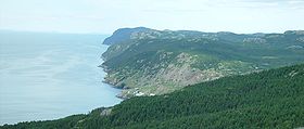
located on the northeast coast of the island of Newfoundland. The bay indents the Avalon Peninsula
with the opening of the bay to the Atlantic Ocean
at the northeast. It is bounded by Cape St. Francis
47°48.63′N 52°47.15′W in the south and Split Point 48°05.99′N 52°50.94′W near Bay de Verde
in the north. It has a maximum depth of 300 meters (980 ft).
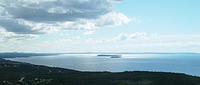
Conception Bay covers an area of 1295 square kilometers and contains several islands, the three major ones being Bell Island
, Little Bell Island and Kelly's Island
. The Bay is fed into by rivers from both the east and west side of the bay, which are then fed into the Atlantic Ocean.
Baía da Conceição or Baia de Comceica and was presumably given in honour of the Feast of the Conception
, December 8. The name first appears on the Oliveriana
map of 1505 – 1508.
Conception bay was the site of Britaniola Colony, established in 1610. It was the site of Sea-Forest Plantation founded in 1610 and Bristol's Hope Plantation founded in 1619.
From the late 1890s to the 1960s, Bell Island was home to an iron ore mine in Wabana
operated most recently by the Dominion Steel and Coal Corporation
(DOSCO); the ore was shipped to DOSCO's steel mill in Sydney, Nova Scotia
. During World War II
, DOSCO cargo ships sitting at anchor, along with the loading pier at Wabana, were the target of German
U-boat
s on at least two occasions. During one particular attack on ore carriers sitting at anchor, a torpedo missed its target and struck the pier, making Bell Island one of the few places in North America to suffer a direct enemy attack (see Attacks on North America during World War II
). The wrecks of the 4 cargo ships sunk during these two attacks are visible at low tide; a memorial on shore is dedicated to the 69 merchant sailors who lost their lives.
service from Bell Island to Portugal Cove
(on the bay's southeastern shore), operating through what locals know as the "Bell Island Tickle."
Humpback whale
s have been known to enter the bay while migrating. Private vessels and tourist charters frequent the bay's waters during the summer months.
Property development in the St. John's exurb of Conception Bay South in recent decades has led to increasing recreational use of the bay.
Canada
Canada is a North American country consisting of ten provinces and three territories. Located in the northern part of the continent, it extends from the Atlantic Ocean in the east to the Pacific Ocean in the west, and northward into the Arctic Ocean...
bay
Bay
A bay is an area of water mostly surrounded by land. Bays generally have calmer waters than the surrounding sea, due to the surrounding land blocking some waves and often reducing winds. Bays also exist as an inlet in a lake or pond. A large bay may be called a gulf, a sea, a sound, or a bight...
located on the northeast coast of the island of Newfoundland. The bay indents the Avalon Peninsula
Avalon Peninsula
The Avalon Peninsula is a large peninsula that makes up the southeast portion of the island of Newfoundland.The peninsula is home to 257,223 people, which is approximately 51% of Newfoundland's population in 2009, and is the location of the provincial capital, St. John's. It is connected to the...
with the opening of the bay to the Atlantic Ocean
Atlantic Ocean
The Atlantic Ocean is the second-largest of the world's oceanic divisions. With a total area of about , it covers approximately 20% of the Earth's surface and about 26% of its water surface area...
at the northeast. It is bounded by Cape St. Francis
Cape St. Francis (Canada)
The Headland of Cape St. Francis is outer extremity marking the boundary of Conception Bay on the Avalon Peninsula of the island of Newfoundland in the Canadian province of Newfoundland and Labrador....
47°48.63′N 52°47.15′W in the south and Split Point 48°05.99′N 52°50.94′W near Bay de Verde
Bay de Verde, Newfoundland and Labrador
Bay de Verde is an incorporated town in Conception Bay on the northern tip of the Bay de Verde Peninsula of Newfoundland and Labrador, Canada. The first recorded inhabitants at Bay de Verde arrived in 1662. Bay de Verde became an incorporated town in 1950.-Geography:Bay de Verde is the northern...
in the north. It has a maximum depth of 300 meters (980 ft).
Conception Bay covers an area of 1295 square kilometers and contains several islands, the three major ones being Bell Island
Bell Island
Bell Island is a Canadian island located off Newfoundland's Avalon Peninsula in Conception Bay.Measuring 9 km in length and 3 km in width, Bell Island has an area of 34 km²...
, Little Bell Island and Kelly's Island
Kelly's Island
Kelly's Island is one of three islands in Conception Bay, Newfoundland, Canada.There are no residences on Kelly's Island. The western end is Crown land which was used by local farmers for cattle grazing. The eastern end of the island was granted, in two identical grants, to two Church of England...
. The Bay is fed into by rivers from both the east and west side of the bay, which are then fed into the Atlantic Ocean.
History
The name Conception Bay comes from the PortuguesePortuguese language
Portuguese is a Romance language that arose in the medieval Kingdom of Galicia, nowadays Galicia and Northern Portugal. The southern part of the Kingdom of Galicia became independent as the County of Portugal in 1095...
Baía da Conceição or Baia de Comceica and was presumably given in honour of the Feast of the Conception
Immaculate Conception
The Immaculate Conception of Mary is a dogma of the Roman Catholic Church, according to which the Virgin Mary was conceived without any stain of original sin. It is one of the four dogmata in Roman Catholic Mariology...
, December 8. The name first appears on the Oliveriana
Oliveriana
Oliveriana is a genus of flowering plants from the orchid family, Orchidaceae.- References :*Pridgeon, A.M., Cribb, P.J., Chase, M.A. & Rasmussen, F. eds. . Genera Orchidacearum 1. Oxford Univ. Press....
map of 1505 – 1508.
Conception bay was the site of Britaniola Colony, established in 1610. It was the site of Sea-Forest Plantation founded in 1610 and Bristol's Hope Plantation founded in 1619.
From the late 1890s to the 1960s, Bell Island was home to an iron ore mine in Wabana
Wabana, Newfoundland and Labrador
Wabana is a Canadian town and the largest and only incorporated community on Bell Island in the province of Newfoundland and Labrador.-Geography:The town is situated on the northeast end of the island and was incorporated in 1950...
operated most recently by the Dominion Steel and Coal Corporation
Dominion Steel and Coal Corporation
The Dominion Steel and Coal Corporation was a Canadian coal mining and steel manufacturing company.Incorporated in 1928 and operational in 1930, DOSCO was predated by the British Empire Steel Corporation which was a merger of the Dominion Coal Company, the Dominion Iron and Steel Company and the...
(DOSCO); the ore was shipped to DOSCO's steel mill in Sydney, Nova Scotia
Sydney, Nova Scotia
Sydney is a Canadian urban community in the province of Nova Scotia. It is situated on the east coast of Cape Breton Island and is administratively part of the Cape Breton Regional Municipality....
. During World War II
World War II
World War II, or the Second World War , was a global conflict lasting from 1939 to 1945, involving most of the world's nations—including all of the great powers—eventually forming two opposing military alliances: the Allies and the Axis...
, DOSCO cargo ships sitting at anchor, along with the loading pier at Wabana, were the target of German
Nazi Germany
Nazi Germany , also known as the Third Reich , but officially called German Reich from 1933 to 1943 and Greater German Reich from 26 June 1943 onward, is the name commonly used to refer to the state of Germany from 1933 to 1945, when it was a totalitarian dictatorship ruled by...
U-boat
U-boat
U-boat is the anglicized version of the German word U-Boot , itself an abbreviation of Unterseeboot , and refers to military submarines operated by Germany, particularly in World War I and World War II...
s on at least two occasions. During one particular attack on ore carriers sitting at anchor, a torpedo missed its target and struck the pier, making Bell Island one of the few places in North America to suffer a direct enemy attack (see Attacks on North America during World War II
Attacks on North America during World War II
The American Theater of World War II was a minor area of operations mainly due to the continent's geographical separation from the central theaters of conflict in Europe and Asia...
). The wrecks of the 4 cargo ships sunk during these two attacks are visible at low tide; a memorial on shore is dedicated to the 69 merchant sailors who lost their lives.
Other information
The provincial government operates a passenger-vehicle ferryFerry
A ferry is a form of transportation, usually a boat, but sometimes a ship, used to carry primarily passengers, and sometimes vehicles and cargo as well, across a body of water. Most ferries operate on regular, frequent, return services...
service from Bell Island to Portugal Cove
Portugal Cove-St. Philip's, Newfoundland and Labrador
Portugal Cove – St. Philip's is a rural seashore community located on the eastern Avalon Peninsula of Newfoundland in the province of Newfoundland & Labrador, Canada. Portugal Cove – St. Philip’s was amalgamated in 1992, and is home to an estimated 6,000 people. Just 10 – 15 minutes from the...
(on the bay's southeastern shore), operating through what locals know as the "Bell Island Tickle."
Humpback whale
Humpback Whale
The humpback whale is a species of baleen whale. One of the larger rorqual species, adults range in length from and weigh approximately . The humpback has a distinctive body shape, with unusually long pectoral fins and a knobbly head. It is an acrobatic animal, often breaching and slapping the...
s have been known to enter the bay while migrating. Private vessels and tourist charters frequent the bay's waters during the summer months.
Property development in the St. John's exurb of Conception Bay South in recent decades has led to increasing recreational use of the bay.