
February 2007 North America Winter Storm
Encyclopedia
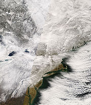
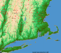
The February 2007 North America Winter Storm (otherwise referred to as the Valentine's Day Blizzard or Valentine's Day Storm) was a massive winter storm
that affected most of the eastern half of North America
, starting on February 12, 2007 and peaking on Valentine's Day
, February 14. The storm produced heavy snowfalls across the midwestern United States
from Nebraska
to Ohio
and produced similar conditions across parts of the northeastern United States
, and into Canada in Ontario
, Quebec
and New Brunswick
. Significant sleet
and freezing rain
fell across the southern Ohio Valley and affected portions of the east coast of the United States, including the cities of Boston
, Baltimore
, Washington, D.C.
, New York City
and Philadelphia.
The southern portion of the storm produced severe thunderstorms with numerous tornadoes reported. One tornado hit a subdivision of New Orleans that was still recovering from the effects of Hurricane Katrina
, which hit the region in August 2005. In total, this storm system was responsible for 37 deaths across 13 U.S. states and Canadian provinces of New Brunswick, Ontario and Quebec. The NOAA classified the storm as a Category 3 "Major" storm. The National Weather Service has determined that this storm was one of the three largest snowstorms to hit the inland areas of the northeastern United States since 1940.
s crossed the eastern half of the continent and brought occasional light snowfalls, a large dip in the Northern branch of the jet stream
favored a more active pattern, which, as it connected with the southern branch, led to the development of the storm.
An area of low pressure tracked across southeastern Canada during the 12th, which brought an arctic front across the Mid Atlantic region late on the 12th. As this occurred, a strong area of high pressure located across central Canada built down into the Northeast, allowing very cold air to spill southward ultimately leading to what is known as cold air damming. This occurs east of the mountains down through the Mid Atlantic states. Meanwhile, a Pacific storm slammed onto the California coast during the 11th and as it moved eastward, a new area of low pressure developed across southeastern Colorado and the Texas Panhandle.
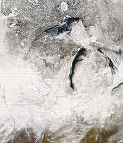
Previously, portions of the Great Lakes
were hit by a significant lake effect snow
event which dumped incredible amounts of snow over portions of central New York. Several areas received over 115 inches (over 2.5 m) of snow in a ten-day period just before the large winter storm as northwesterly winds and unfrozen lake surfaces due to the early winter warm weather favored the heavy snowfall. Several areas across Michigan
and Ontario also received significant amounts of snow with locally 1 meter (3.3 ft) of snow east of Georgian Bay
in Ontario.
 From February 10 to 11, a low pressure system developed near the Rockies
and moved towards the Great Plains
of the United States. It later tracked across the Ohio Valley
and merged with a new coastal low. It then moved over eastern Quebec on Valentine's Day before exiting northeastern Quebec and Newfoundland and Labrador
on February 16. It dumped over six inches (15 cm) of snow across numerous areas from Iowa
to New Brunswick
, including major cities such as Akron
, Detroit, Champaign-Urbana, Chicago
, Cleveland, Columbus
, Springfield
, Peoria
, Indianapolis
, Fort Wayne
, Dayton
, Toledo
, Cincinnati, London
, Hamilton
, the Niagara Region, Toronto
, Sherbrooke, Saguenay
, Trois-Rivières
, Ottawa
, Montreal
, Quebec City
, Pittsburgh, Buffalo
, Rochester
, Windsor
, Syracuse
and Albany
. This also includes areas such as Northern Oswego County, New York
, which received historic lake effect snow
fall amounts in the week prior to the storm.
In addition to the general snowfall, snow squalls coming from Lake Ontario
gave local amounts of over 2 feet (600 mm) of snow near the Hamilton and Niagara regions, where 1 foot (0.3048 m) of snow had already fallen on February 13.
Heavy ice amounts fell for locations along Interstate 95
from Maine
to Virginia
and west towards southern Ohio
and Indiana
. Ice was expected for parts of the Canadian Maritimes.
This storm became impressive as it moved into the Ohio Valley during the 13th. However as additional energy moved into the eastern part of the country, a new area of low pressure developed near the North Carolina coast late on the 13th. This allowed mainly light snow to overspread the region from south to north during the early morning hours of the 13th. Low pressure developed in the southern Plains on Monday the 12th as a cold front pushed southward across the Northeast. By Tuesday the 13th, the storm moved eastward across the lower Mississippi Valley while the cold front became stationary in the Carolinas. On the night of the 13th, the primary low moved into the far eastern Ohio Valley while a secondary low developed on the stalled front in the Carolinas. During the day on Wednesday the 14th, this secondary low strengthened rapidly and moved northeastward along the mid-Atlantic and New England coasts while the primary low dissipated in the central Appalachians. By Thursday the 15th, the storm had moved into eastern Canada.
 Maine
Maine
Governor John Baldacci
declared a state of emergency in order to assure heating oil for residents of the state, which was one of the hardest hit areas by the snowstorm.
Due to the additional heavy snowfall, New York Governor Eliot Spitzer
called in the National Guard
to assist in the snow removal efforts in the areas hit by the lake effect snow
storm.
In Pennsylvania
, Governor Ed Rendell
declared a disaster emergency across the entire state on the 15th. PPL Electric Utilities Corporation
reported 1,542 customers were without power for a time during the storm in the Lancaster
, Harrisburg
and Allentown
areas. Snow began across between 6 AM and 7 AM EST on the 13th in Philadelphia, Delaware
, Chester
, Montgomery
and Berks
counties. The snow then overspread Bucks
, Northampton
, Lehigh
and Carbon
counties between 8 AM and 10 AM EST, but held off in Monroe County
until the early afternoon hours. There was a lull in the precipitation during the evening hours of the 13th especially across southeastern Pennsylvania, however the precipitation became widespread overnight and during the early morning hours of the 14th.
As some warmer air began to move in above the surface, the snow mixed with and changed to sleet and freezing rain between 6 PM and 7 PM EST on the 13th in Philadelphia and Delaware Counties, then between 7 PM and 11 PM across most other areas in eastern Pennsylvania. The southern Poconos saw less mixed precipitation, however there was a period of mixed precipitation between about 7:30 PM on the 13th and 11:30 AM on the 14th. For a brief time during the afternoon of the 14th, temperatures rose a couple of degrees above freezing with no precipitation falling. Temperatures then dropped below freezing again by the late afternoon of the 14th with a period of snow before the precipitation came to an end between 8:30 PM and 10 PM on the 14th. Wraparound snow showers lingered in Monroe and Carbon Counties until 2 AM EST on the 15th.
In Berks County, snow and sleet along with very cold temperatures combined with some accidents and other aspects to cause a 50-mile backup on Interstate 78
. Many motorists, including more than 100 trucks, were stuck on the interstate for nearly 24 hours, without food, water and running out of fuel. At 12:26 PM on the 14th, a caller tells a 911 center he???s been stuck in traffic on westbound Interstate 78 near the Berks-Lehigh county line for more than an hour. At 1:02 PM, a truck driver tells the Berks Communications Center about a seven-mile backup on the eastbound lanes of Interstate 78 near Hamburg
. At 4:40 PM, a 911 caller asked to speak to the Berks Emergency Management Agency. The Berks Deputy Coordinator took the call. At 4:59 PM, The Berks Deputy Coordinator called the State Emergency Operations Center and was told the center learned of the backup at 4:33 PM. At 5:22 PM, Berks Emergency Management calls the state police at the Hamburg barracks but cannot get through, so he decided to drive there. At 6:08 PM, the Berks Emergency Management Deputy Coordinator finds that the Hamburg barracks is without power and phones. At 6:27 PM, a senior decision-maker from PennDOT is requested to arrive at the Hamburg state police barracks to help with communications. At 9:30 PM, a PennDOT
supervisor arrived in Hamburg.
At 10:30 PM, all westbound Interstate 78 traffic is stopped at the Hamburg exit due to numerous disabled vehicles. At 10:40 PM, Governor Ed Rendell declared a disaster emergency. On the 15th at 3:54 AM, state troopers and emergency personnel began walking miles of Interstate 78, waking up truckers who have gone to sleep as traffic begins to move. At 5 PM on the 15th, the state orders Interstate 78 shut down in both directions from Interstate 81 in Lebanon County to Route 100 in Lehigh County. At 6 PM on the 15th, plowing begins and continued through the night. Additional snow removing equipment was brought in from the western part of the state to help with the clearing of the highway. Highway officials along with the National Guard
and State Police
worked to clear the stuck trucks and cars from the highway, therefore plowing and ice removal can get fully underway. On the 16th, the interstate remained closed throughout the day as crews continued to plow and remove ice. On the 17th at 4 PM, the interstate reopened.
The Exeter Township snow emergency, which was declared on the 14th, was extended through 4 PM on the 15th. Several schools across the county were closed on the 14th, with some also closed on the 15th. Across the Lehigh Valley
: In Lehigh County, The city of Allentown
declared a snow emergency early on the 14th, which was then lifted at 8 PM on the 14th. The weight of snow and ice, on the 14th, brought down the dome over the swimming pool at the West End Racquet and Fitness Club in South Whitehall Township. The dome itself was destroyed. Also, the Brookside Country Club in Wescosville also reported dome damage as a result of the snow and ice. In Northampton County
, an 83-year-old woman was found dead on the rear porch of her home from hypothermia. Also in Bethlehem
, a pedestrian was hospitalized after a private snowplow operator backed over him while clearing the Sheetz gas station parking lot at 3201 Schoenersville Road on the 14th. County Emergency Dispatch officials reported about a dozen or so minor vehicle accidents due to the slippery conditions. The snow and ice was too much on the 15th for a dome covering a soccer field at the Iron Lakes Sports Club on Shankweiler Road in North Catasauqua that it collapsed.
In the Poconos, in Carbon County
, The Mansion Hill (SR 209) exiting Jim Thorpe
towards Lehighton
was closed for most of the 14th due to snow slides blocking the major artery or tractor-trailer trucks becoming stuck and blocking the travel lanes. The road reopened about 2:30 PM on the 14th, however it was shut down again at 3:06 PM due to an accident. This was a main trouble spot as the snow and sleet reportedly drifted on the hill across part of the highway. Drifts were reported to be higher than some vehicles. At 8:20 AM on the 14th, it was decided that drifting was occurring more frequently than road crews could clear, resulting in the heavily traveled road being closed. All schools in the county canceled classes as early as the evening of the 13th. Lansford
continued their state of emergency on the 15th, which was issued on the 14th. This means that all non-essential travel should be avoided. One accident occurred when a tractor-trailer jack-knifed on the Mansion House Hill, Route 209, in Jim Thorpe at about 4 AM on the 14th. The Pennsylvania Turnpike
s Lehighton interchange was closed because of a tractor-trailer crash on the 14th, and state police closed Interstate 81 late in the afternoon of the 14th, deeming it impassable. Interstate 380
also was closed because of bad road conditions.
In Monroe County
, state police closed Interstates
80
and 380
during the afternoon of the 14th because of bad road conditions. Interstate 80 was closed between Interstates 81
and 380. The combination of a heavy snowfall then a mix of sleet, snow and freezing rain made for hazardous road conditions. The mixed precipitation made it more difficult for some road crews to keep up. At 4 PM EST on the 17th the interstates reopened after ice was removed and the road surfaces was safe for travel. In and around the Greater Philadelphia Metropolitan area
, in Bucks County
, slippery road conditions contributed to a tractor-trailer accident on the 14th on Route 309 in Richland Township. The highway was closed for more than an hour, which forced motorists to detour on slush-covered side streets.
In Philadelphia itself, the combination of snow and sleet closed many of the schools, delayed flights, trains and buses. The school district parochial schools were closed on the 14th, as were the regional and central administrative offices. During the midday hours on the 14th, giant slabs of ice slid off tops of buildings in Center City and crashed to the ground. Chunks of ice as large as three feet wide made their way to the pavement from high up. Police started to block off areas where the ice was falling, however one man was hit in the head by the falling ice and was knocked to the ground.
Schenectady
, Schoharie
, Montgomery
, Washington
, Essex
, Warren
and Clinton
counties in New York state, which were affected by extensive snowfall from the storm, had declared a state of emergency while several other counties and towns declared snow emergencies.
Virginia
Gov. Timothy Kaine declared a statewide emergency in advance of the storm, directing state agencies to help in the response to and recovery from the storm.
Pennsylvania
Gov. Ed Rendell
declared a statewide disaster emergency in response to the poor road conditions and ensuing highway closings.
received 10.2 inches (259 mm) of snow, while Midway Airport received 12 inches (304.8 mm). The Midway total was the largest amount of snow received in the month of February for one midnight-to-midnight day since records began to be kept in 1928.
Twelve to sixteen inches of snowfall and blizzard conditions in central Illinois canceled classes at the University of Illinois at Urbana-Champaign
for two days, the first time classes had been canceled since 1979. Areas of the Appalachian Mountains
in northern New England and Quebec received accumulations of over 16 inches (40.6 cm) with local amount exceeding 36 inches (914.4 mm) in parts of Vermont and 42 inches (1,066.8 mm) in the Adirondacks in New York state. Also in New York state, in the hills and valleys south of Syracuse
, snowfall depths ranged from 24 to 45 inches . Snowfall rates of 5 to 6 inches per hour occurred in areas of western Schoharie County
, with total storm accumulations in this county approaching three feet. The city of Hamilton, Ontario
and the Niagara region, at their highest elevations, received just over 27.6 inches (70.1 cm) due to snow squalls off of Lake Ontario. Burlington, Vermont
recorded record 24-hour snowfall, with 25.3 inches (64.3 cm). Boston and Hartford, however, saw very little precipitation from the storm. In fact, Boston is close to setting a record for the least snow in any season.
A notable feature of the system was its array of precipitation type. While the interior sections of the Northeast received mostly snow from the system, the Mid-Atlantic received snow, sleet, freezing rain and non-freezing rain. Due to the three-dimensional nature of the atmosphere, warm air was poised to overtake the cold air closer to the ground, causing precipitation to melt, then refreeze as either sleet or freezing rain. As temperatures hovered around freezing on the southern edge of the storm track, light snow accompanied freezing rain and sleet. The freezing rain coated all surfaces with thick layers of ice, including power lines and tree limbs which break under the additional weight. Some locations in the Mid-Atlantic received several inches of sleet. Four inches (100 mm) of sleet caused travel difficulties and hampered cleanup efforts in New York City
. New York City's sanitation department admitted to not plowing city streets, expecting the frozen precipitation to change from ice to rain. However, this never happened. Instead, temperatures dropped very quickly and caused the slush on sidewalks and roads to freeze into thick, rock hard sheets of ice. Streets were almost impassable during the evening rush hour resulting in complete chaos.Along coastal New England,a mix of rain,sleet,and freezing rain resulted in decreased snow amounts in coastal areas of New England.in coastal Maine,snowfall amounts were restricted to 6-12 inches,while inland sections of the state got as much as 29.8 inches of snow.
Ice accumulations in Virginia and Maryland reached locally three-quarters of an inch (20 mm) while it reached 1 inches (2.5 cm) in central Ohio near Columbus
and Xenia
, with up to 0.7 inches (1.8 cm) near Cincinnati.
The effect on much of Michigan
by the storm was light, although the extreme southern part of the state was hard hit with heavy snowfall, especially the Detroit Metro area. Wind whipped snow accumulations ranged from 7 to 10 inches fell throughout the area, especially the southeastern suburbs, including 8.5 inches (21.6 cm) at both Detroit Metropolitan Airport and Wyandotte
, and 8.4 inches (21.3 cm) in Dundee
. Drifts were as high as two to three feet , and the snow was very powdery as it fell with temperatures around 10 °F (-12.2 °C).
Due to the near-record amounts of snow in the Appalachian Mountain chain, National Weather Service officials had issued statement for a higher risk of avalanche
s across northern New England.
 Blizzard conditions were reported across most of the Midwest from Illinois
to Ohio
. Numerous flights were canceled due to the snow and ice across various airports including in Toronto, Ottawa
, Quebec City
, Montreal
, Kansas City
, Indianapolis
, St. Louis, Cleveland, Boston and Cincinnati
. 900 flights were canceled at Chicago
's O'Hare International Airport
.
Lackawanna County and Luzerne County in northeastern Pennsylvania
received so much snow that every highway was closed.
At New York's John F. Kennedy International Airport
, several empty JetBlue airplanes were frozen to the parking stands at the gates and incoming flights could not access the stands as a result, while outgoing flights already taxiing were ordered to hold on the taxiway due to weather conditions. Many passengers in planes, either inbound or outbound, were held in the planes, eating peanuts and other snacks for as much as 10 hours before the decision was made to cancel the outgoing flights or a gate had opened for the inbound ones.
Several airports including Bradley International Airport
in Connecticut
, Washington's Ronald Reagan National Airport, and John C. Munro International Airport
in Hamilton were completely shut down for several hours. GO Train in Toronto
and Amtrak
train service from Boston was also disrupted. In Scranton, Pennsylvania
the Toyota Pavilion at Montage Mountain
collapsed under the weight of the snow on February 15, 2007. Strong winds also accompanied the storm but damage was minimal, though a radio tower pole was toppled by 40 mph (64.4 km/h) winds in Ohio.
Road traveling was extensively slowed down and numerous accidents and pile-ups were reported across several states and in Ontario. One of the accidents on the Ohio Turnpike
involved two tractor-trailers which fell several hundred feet, and another one on Highway 403
in Hamilton involved three tractor-trailers and five cars which forced the closure of the road. Numerous other major roads were also temporarily shutdown, including Highway 401
in Ontario due to a fatal accident in Napanee and Autoroute 20
and Route 132
in eastern Quebec between Quebec City and Rimouski.
In Sherbrooke, Quebec, where nearly 2 foot (0.6096 m) of snow fell, several hundred students were forced to sleep at schools as buses were unable to travel in the near blizzard conditions. The school board was criticized for opening schools on that day.
Severe ice caused a 50 miles (80.5 km) stretch of Interstate 78
in Pennsylvania between Lebanon County and Allentown
to be shut down, stranding motorists for upwards of 24 hours and requiring the National Guard
to be called in. Other stretches of highway throughout Pennsylvania were shut down, including Interstate 80
, 81
, and after the storm, even the Pennsylvania Turnpike
. On February 16, Governor Ed Rendell
called for a thorough investigation into how the state handled the winter weather emergency, citing a lack of communication and quick action as the cause of the problems, and even going so far as to taking responsibility for the situation.
, three in Nebraska
, two in New York
, two in Illinois
, two in New Jersey
, two in Indiana
, two in Delaware
, one in New Brunswick
, five in Quebec
, one in Louisiana
, one in New Hampshire
, six in Vermont
, one in Missouri
, one in Pennsylvania
, one in Virginia
, and six in Ohio
. In addition to traffic accidents, fatalities were reported due to tornadoes, heart attacks while shoveling, roof collapses due to heavy snow, falling tree branches and carbon monoxide poisoning. In Quebec City, a 16-year old boy disappeared during the snowstorm and was found dead three days later in a snow bank.
 The inclement weather caused many educational institutions, such as universities and secondary school
s, to close. Among these were University of Michigan–Dearborn in Dearborn, Michigan
, Ball State University
in Muncie, Indiana
, College of Mount St. Joseph
in Cincinnati, Ohio
, Western Illinois University
in Macomb, Illinois
, Eastern Illinois University
in Charleston, Illinois
, Champlain College
and the University of Vermont
in Burlington, Vermont
, Mount St. Mary's University in Emmitsburg, Maryland
, Illinois State University
in Normal, Illinois
, Western Connecticut State University
in Danbury, Connecticut
, Oberlin College
in Oberlin, Ohio
, The University of Akron, Kent State University
, Ohio Northern University
in Ada, Ohio
, Baldwin-Wallace College
in Berea, Ohio
, The University of Toledo
in Toledo, Ohio
, the University at Albany, Rensselaer Polytechnic Institute
, Case Western Reserve University
in Cleveland, The Pennsylvania State University, Lyndon State College
in Lyndonville, Vermont
, George Mason University
, Northern Virginia Community College
and James Madison University
in Virginia, Sherbrooke University and Bishop's University
, in Quebec, the University of Maryland
in College Park, Maryland
, UMBC in Catonsville, Maryland
, Georgetown University
in Washington, DC, Cornell University
, University of Pittsburgh
, Chatham College
in Pittsburgh
, and West Chester University of Pennsylvania
. Tornado damage, rather than snow fall, caused Tulane University
to cancel classes. Several elementary, middle, and high schools were closed three days in a row in central New York. Public schools in the "W Towns" in eastern Massachusetts (Weston
, Wayland
, and Wellesley
) did have school that day despite the fact that almost every other town in the state had the day off. Several schools' classes were canceled after years without a snow day
. Dartmouth College
shut down campus operations on February 14. Essential employees remained staffed, and classes were held at professors' discretion. It was the first snow day for the college since the 70s, and its second in its 238-year history.
Ohio State University
in Columbus, Ohio
closed its campus for two days, beginning February 13, for the third time in 25 years. Syracuse University
canceled all classes after 12:45 pm on Wednesday, closing for only the second time in its 130-year history; for SUNY Geneseo, the previous snow day had occurred 14 years ago; for Ithaca College
, the first time in 13 years; for the University of Toledo
, the first time in 22 years due to winter-related conditions. The University of Illinois
canceled their classes for two consecutive days for the first time in at least 27 years. A blizzard warning forced Purdue University
to suspend classes for the first time in 13 years. SUNY Oneonta closed its doors for the first time since the 1970s, and stayed closed for 3 days for the first time in its 119-year history. For the first time in six years, Youngstown State University
in Youngstown, Ohio
canceled classes as a result of the snow. On February 14, for only the third time in school history, Bucknell University
in Lewisburg, Pennsylvania
canceled classes as a result of the snow. Susquehanna University
in nearby Selinsgrove
, however, remained open with no official cancellations.
, presidential
candidate
Mitt Romney
(R
) was forced to cancel a campaign appearance. A global warming
hearing
in the U.S. House of Representatives
' Subcommittee on Energy and Air Quality scheduled for February 14 and a showing of the film An Inconvenient Truth
at Maryville University
in St. Louis
were also cancelled.

(14,000), Maryland
(at least 135,000 customers, including 69,000 in Anne Arundel County
and 25,000 in Prince George's County, Maryland
), New Jersey
(36,000), Pennsylvania (10,000 in the Pittsburgh region), Virginia (7,800), and New York (18,000) on Long Island
. By 10:00 am Thursday, February 15, about 73,000 homes were without electricity in the Washington DC metropolitan area. Most of those outages were from an ice storm that hit areas from the southern Ohio Valley towards the Atlantic
Coast.
, Butch Callery, postponed Valentine's Day until Saturday.
Travelers heading to Mardi Gras
had to take a train to Washington D.C. and then drive a rental vehicle to New Orleans.
was reported on February 12 in the New Orleans area killing one person and injuring a dozen in the Pontchartrain Park neighborhood, one of the hardest hit areas by Hurricane Katrina due to the flood waters. The woman was inside a FEMA trailer
when it was hit by the EF2 twister. In addition to significant structural damage to numerous buildings including a dozen destroyed, 20,000 residents lost power across the metropolitan area. On the same day the tornado, or a related series of tornados, also struck the Carrollton
and Hollygrove
neighborhoods of New Orleans and the town of Westwego, Louisiana
.
Severe weather was also reported south of Birmingham
, Alabama
, near Jackson
, Mississippi
as well as in Georgia
, Florida
, and South Carolina
. 21 tornadoes in total were reported on February 12 and February 13 across Mississippi
, Louisiana
and Alabama
and 17 have been confirmed with no tornadoes stronger than EF2 on the Enhanced Fujita Scale
. A particularly strong squall line passed through Alabama on the evening of February 13 with reports of baseball-sized hail in Montgomery, Alabama
.
Winter storm
A winter storm is an event in which the dominant varieties of precipitation are formed that only occur at low temperatures, such as snow or sleet, or a rainstorm where ground temperatures are low enough to allow ice to form...
that affected most of the eastern half of North America
North America
North America is a continent wholly within the Northern Hemisphere and almost wholly within the Western Hemisphere. It is also considered a northern subcontinent of the Americas...
, starting on February 12, 2007 and peaking on Valentine's Day
Valentine's Day
Saint Valentine's Day, commonly shortened to Valentine's Day, is an annual commemoration held on February 14 celebrating love and affection between intimate companions. The day is named after one or more early Christian martyrs named Saint Valentine, and was established by Pope Gelasius I in 496...
, February 14. The storm produced heavy snowfalls across the midwestern United States
Midwestern United States
The Midwestern United States is one of the four U.S. geographic regions defined by the United States Census Bureau, providing an official definition of the American Midwest....
from Nebraska
Nebraska
Nebraska is a state on the Great Plains of the Midwestern United States. The state's capital is Lincoln and its largest city is Omaha, on the Missouri River....
to Ohio
Ohio
Ohio is a Midwestern state in the United States. The 34th largest state by area in the U.S.,it is the 7th‑most populous with over 11.5 million residents, containing several major American cities and seven metropolitan areas with populations of 500,000 or more.The state's capital is Columbus...
and produced similar conditions across parts of the northeastern United States
Northeastern United States
The Northeastern United States is a region of the United States as defined by the United States Census Bureau.-Composition:The region comprises nine states: the New England states of Connecticut, Maine, Massachusetts, New Hampshire, Rhode Island and Vermont; and the Mid-Atlantic states of New...
, and into Canada in Ontario
Ontario
Ontario is a province of Canada, located in east-central Canada. It is Canada's most populous province and second largest in total area. It is home to the nation's most populous city, Toronto, and the nation's capital, Ottawa....
, Quebec
Quebec
Quebec or is a province in east-central Canada. It is the only Canadian province with a predominantly French-speaking population and the only one whose sole official language is French at the provincial level....
and New Brunswick
New Brunswick
New Brunswick is one of Canada's three Maritime provinces and is the only province in the federation that is constitutionally bilingual . The provincial capital is Fredericton and Saint John is the most populous city. Greater Moncton is the largest Census Metropolitan Area...
. Significant sleet
Ice storm
An ice storm is a type of winter storm characterized by freezing rain, also known as a glaze event or in some parts of the United States as a silver thaw. The U.S. National Weather Service defines an ice storm as a storm which results in the accumulation of at least of ice on exposed surfaces...
and freezing rain
Freezing rain
Freezing rain is the name given to rain that falls when surface temperatures are below freezing. The raindrops become supercooled while passing through a sub-freezing layer of air, many hundred feet , just above the surface, and then freeze upon impact with any object they encounter. The resulting...
fell across the southern Ohio Valley and affected portions of the east coast of the United States, including the cities of Boston
Boston
Boston is the capital of and largest city in Massachusetts, and is one of the oldest cities in the United States. The largest city in New England, Boston is regarded as the unofficial "Capital of New England" for its economic and cultural impact on the entire New England region. The city proper had...
, Baltimore
Baltimore
Baltimore is the largest independent city in the United States and the largest city and cultural center of the US state of Maryland. The city is located in central Maryland along the tidal portion of the Patapsco River, an arm of the Chesapeake Bay. Baltimore is sometimes referred to as Baltimore...
, Washington, D.C.
Washington, D.C.
Washington, D.C., formally the District of Columbia and commonly referred to as Washington, "the District", or simply D.C., is the capital of the United States. On July 16, 1790, the United States Congress approved the creation of a permanent national capital as permitted by the U.S. Constitution....
, New York City
New York City
New York is the most populous city in the United States and the center of the New York Metropolitan Area, one of the most populous metropolitan areas in the world. New York exerts a significant impact upon global commerce, finance, media, art, fashion, research, technology, education, and...
and Philadelphia.
The southern portion of the storm produced severe thunderstorms with numerous tornadoes reported. One tornado hit a subdivision of New Orleans that was still recovering from the effects of Hurricane Katrina
Hurricane Katrina
Hurricane Katrina of the 2005 Atlantic hurricane season was a powerful Atlantic hurricane. It is the costliest natural disaster, as well as one of the five deadliest hurricanes, in the history of the United States. Among recorded Atlantic hurricanes, it was the sixth strongest overall...
, which hit the region in August 2005. In total, this storm system was responsible for 37 deaths across 13 U.S. states and Canadian provinces of New Brunswick, Ontario and Quebec. The NOAA classified the storm as a Category 3 "Major" storm. The National Weather Service has determined that this storm was one of the three largest snowstorms to hit the inland areas of the northeastern United States since 1940.
Prior to the storm
In sharp contrast to the mostly mild weather in the first few weeks of winter, the eastern half of the continent was under the influence of cold temperatures. Numerous areas had substantial snowfall deficits before this storm. After several weak Alberta ClipperAlberta clipper
An Alberta clipper is a fast moving low pressure area which generally affects the central provinces of Canada and parts of the Upper Midwest and Great Lakes regions of the United States. Most clippers occur between December and February, but can also occur occasionally in the month of November...
s crossed the eastern half of the continent and brought occasional light snowfalls, a large dip in the Northern branch of the jet stream
Jet stream
Jet streams are fast flowing, narrow air currents found in the atmospheres of some planets, including Earth. The main jet streams are located near the tropopause, the transition between the troposphere and the stratosphere . The major jet streams on Earth are westerly winds...
favored a more active pattern, which, as it connected with the southern branch, led to the development of the storm.
An area of low pressure tracked across southeastern Canada during the 12th, which brought an arctic front across the Mid Atlantic region late on the 12th. As this occurred, a strong area of high pressure located across central Canada built down into the Northeast, allowing very cold air to spill southward ultimately leading to what is known as cold air damming. This occurs east of the mountains down through the Mid Atlantic states. Meanwhile, a Pacific storm slammed onto the California coast during the 11th and as it moved eastward, a new area of low pressure developed across southeastern Colorado and the Texas Panhandle.
Previously, portions of the Great Lakes
Great Lakes
The Great Lakes are a collection of freshwater lakes located in northeastern North America, on the Canada – United States border. Consisting of Lakes Superior, Michigan, Huron, Erie, and Ontario, they form the largest group of freshwater lakes on Earth by total surface, coming in second by volume...
were hit by a significant lake effect snow
Lake effect snow
Lake-effect snow is produced during cooler atmospheric conditions when cold winds move across long expanses of warmer lake water, providing energy and picking up water vapor which freezes and is deposited on the leeward shores...
event which dumped incredible amounts of snow over portions of central New York. Several areas received over 115 inches (over 2.5 m) of snow in a ten-day period just before the large winter storm as northwesterly winds and unfrozen lake surfaces due to the early winter warm weather favored the heavy snowfall. Several areas across Michigan
Michigan
Michigan is a U.S. state located in the Great Lakes Region of the United States of America. The name Michigan is the French form of the Ojibwa word mishigamaa, meaning "large water" or "large lake"....
and Ontario also received significant amounts of snow with locally 1 meter (3.3 ft) of snow east of Georgian Bay
Georgian Bay
Georgian Bay is a large bay of Lake Huron, located entirely within Ontario, Canada...
in Ontario.
Storm track
Rocky Mountains
The Rocky Mountains are a major mountain range in western North America. The Rocky Mountains stretch more than from the northernmost part of British Columbia, in western Canada, to New Mexico, in the southwestern United States...
and moved towards the Great Plains
Great Plains
The Great Plains are a broad expanse of flat land, much of it covered in prairie, steppe and grassland, which lies west of the Mississippi River and east of the Rocky Mountains in the United States and Canada. This area covers parts of the U.S...
of the United States. It later tracked across the Ohio Valley
Ohio River
The Ohio River is the largest tributary, by volume, of the Mississippi River. At the confluence, the Ohio is even bigger than the Mississippi and, thus, is hydrologically the main stream of the whole river system, including the Allegheny River further upstream...
and merged with a new coastal low. It then moved over eastern Quebec on Valentine's Day before exiting northeastern Quebec and Newfoundland and Labrador
Newfoundland and Labrador
Newfoundland and Labrador is the easternmost province of Canada. Situated in the country's Atlantic region, it incorporates the island of Newfoundland and mainland Labrador with a combined area of . As of April 2011, the province's estimated population is 508,400...
on February 16. It dumped over six inches (15 cm) of snow across numerous areas from Iowa
Iowa
Iowa is a state located in the Midwestern United States, an area often referred to as the "American Heartland". It derives its name from the Ioway people, one of the many American Indian tribes that occupied the state at the time of European exploration. Iowa was a part of the French colony of New...
to New Brunswick
New Brunswick
New Brunswick is one of Canada's three Maritime provinces and is the only province in the federation that is constitutionally bilingual . The provincial capital is Fredericton and Saint John is the most populous city. Greater Moncton is the largest Census Metropolitan Area...
, including major cities such as Akron
Akron, Ohio
Akron , is the fifth largest city in the U.S. state of Ohio and the county seat of Summit County. It is located in the Great Lakes region approximately south of Lake Erie along the Little Cuyahoga River. As of the 2010 census, the city had a population of 199,110. The Akron Metropolitan...
, Detroit, Champaign-Urbana, Chicago
Chicago
Chicago is the largest city in the US state of Illinois. With nearly 2.7 million residents, it is the most populous city in the Midwestern United States and the third most populous in the US, after New York City and Los Angeles...
, Cleveland, Columbus
Columbus, Ohio
Columbus is the capital of and the largest city in the U.S. state of Ohio. The broader metropolitan area encompasses several counties and is the third largest in Ohio behind those of Cleveland and Cincinnati. Columbus is the third largest city in the American Midwest, and the fifteenth largest city...
, Springfield
Springfield, Illinois
Springfield is the third and current capital of the US state of Illinois and the county seat of Sangamon County with a population of 117,400 , making it the sixth most populated city in the state and the second most populated Illinois city outside of the Chicago Metropolitan Area...
, Peoria
Peoria, Illinois
Peoria is the largest city on the Illinois River and the county seat of Peoria County, Illinois, in the United States. It is named after the Peoria tribe. As of the 2010 census, the city was the seventh-most populated in Illinois, with a population of 115,007, and is the third-most populated...
, Indianapolis
Indianapolis
Indianapolis is the capital of the U.S. state of Indiana, and the county seat of Marion County, Indiana. As of the 2010 United States Census, the city's population is 839,489. It is by far Indiana's largest city and, as of the 2010 U.S...
, Fort Wayne
Fort Wayne, Indiana
Fort Wayne is a city in the US state of Indiana and the county seat of Allen County. The population was 253,691 at the 2010 Census making it the 74th largest city in the United States and the second largest in Indiana...
, Dayton
Dayton, Ohio
Dayton is the 6th largest city in the U.S. state of Ohio and the county seat of Montgomery County, the fifth most populous county in the state. The population was 141,527 at the 2010 census. The Dayton Metropolitan Statistical Area had a population of 841,502 in the 2010 census...
, Toledo
Toledo, Ohio
Toledo is the fourth most populous city in the U.S. state of Ohio and is the county seat of Lucas County. Toledo is in northwest Ohio, on the western end of Lake Erie, and borders the State of Michigan...
, Cincinnati, London
London, Ontario
London is a city in Southwestern Ontario, Canada, situated along the Quebec City – Windsor Corridor. The city has a population of 352,395, and the metropolitan area has a population of 457,720, according to the 2006 Canadian census; the metro population in 2009 was estimated at 489,274. The city...
, Hamilton
Hamilton, Ontario
Hamilton is a port city in the Canadian province of Ontario. Conceived by George Hamilton when he purchased the Durand farm shortly after the War of 1812, Hamilton has become the centre of a densely populated and industrialized region at the west end of Lake Ontario known as the Golden Horseshoe...
, the Niagara Region, Toronto
Toronto
Toronto is the provincial capital of Ontario and the largest city in Canada. It is located in Southern Ontario on the northwestern shore of Lake Ontario. A relatively modern city, Toronto's history dates back to the late-18th century, when its land was first purchased by the British monarchy from...
, Sherbrooke, Saguenay
Saguenay, Quebec
Saguenay is a city in the Saguenay-Lac-Saint-Jean region of Quebec, Canada, on the Saguenay River, about north of Quebec City....
, Trois-Rivières
Trois-Rivières
Trois-Rivières means three rivers in French and may refer to:in Canada*Trois-Rivières, the largest city in the Mauricie region of Quebec, Canada*Circuit Trois-Rivières, a racetrack in Trois-Rivières, Quebec...
, Ottawa
Ottawa
Ottawa is the capital of Canada, the second largest city in the Province of Ontario, and the fourth largest city in the country. The city is located on the south bank of the Ottawa River in the eastern portion of Southern Ontario...
, Montreal
Montreal
Montreal is a city in Canada. It is the largest city in the province of Quebec, the second-largest city in Canada and the seventh largest in North America...
, Quebec City
Quebec City
Quebec , also Québec, Quebec City or Québec City is the capital of the Canadian province of Quebec and is located within the Capitale-Nationale region. It is the second most populous city in Quebec after Montreal, which is about to the southwest...
, Pittsburgh, Buffalo
Buffalo, New York
Buffalo is the second most populous city in the state of New York, after New York City. Located in Western New York on the eastern shores of Lake Erie and at the head of the Niagara River across from Fort Erie, Ontario, Buffalo is the seat of Erie County and the principal city of the...
, Rochester
Rochester, New York
Rochester is a city in Monroe County, New York, south of Lake Ontario in the United States. Known as The World's Image Centre, it was also once known as The Flour City, and more recently as The Flower City...
, Windsor
Windsor, Ontario
Windsor is the southernmost city in Canada and is located in Southwestern Ontario at the western end of the heavily populated Quebec City – Windsor Corridor. It is within Essex County, Ontario, although administratively separated from the county government. Separated by the Detroit River, Windsor...
, Syracuse
Syracuse, New York
Syracuse is a city in and the county seat of Onondaga County, New York, United States, the largest U.S. city with the name "Syracuse", and the fifth most populous city in the state. At the 2010 census, the city population was 145,170, and its metropolitan area had a population of 742,603...
and Albany
Albany, New York
Albany is the capital city of the U.S. state of New York, the seat of Albany County, and the central city of New York's Capital District. Roughly north of New York City, Albany sits on the west bank of the Hudson River, about south of its confluence with the Mohawk River...
. This also includes areas such as Northern Oswego County, New York
Oswego County, New York
Oswego County is a county located in the U.S. state of New York. As of the 2010 Census, the estimated population was 122,109. The City of Oswego and the Village of Pulaski serve as the dual county seats in a two shire system of government...
, which received historic lake effect snow
Lake effect snow
Lake-effect snow is produced during cooler atmospheric conditions when cold winds move across long expanses of warmer lake water, providing energy and picking up water vapor which freezes and is deposited on the leeward shores...
fall amounts in the week prior to the storm.
In addition to the general snowfall, snow squalls coming from Lake Ontario
Lake Ontario
Lake Ontario is one of the five Great Lakes of North America. It is bounded on the north and southwest by the Canadian province of Ontario, and on the south by the American state of New York. Ontario, Canada's most populous province, was named for the lake. In the Wyandot language, ontarío means...
gave local amounts of over 2 feet (600 mm) of snow near the Hamilton and Niagara regions, where 1 foot (0.3048 m) of snow had already fallen on February 13.
Heavy ice amounts fell for locations along Interstate 95
Interstate 95
Interstate 95 is the main highway on the East Coast of the United States, running parallel to the Atlantic Ocean from Maine to Florida and serving some of the most populated urban areas in the country, including Boston, Providence, New Haven, New York City, Newark, Philadelphia, Baltimore,...
from Maine
Maine
Maine is a state in the New England region of the northeastern United States, bordered by the Atlantic Ocean to the east and south, New Hampshire to the west, and the Canadian provinces of Quebec to the northwest and New Brunswick to the northeast. Maine is both the northernmost and easternmost...
to Virginia
Virginia
The Commonwealth of Virginia , is a U.S. state on the Atlantic Coast of the Southern United States. Virginia is nicknamed the "Old Dominion" and sometimes the "Mother of Presidents" after the eight U.S. presidents born there...
and west towards southern Ohio
Ohio
Ohio is a Midwestern state in the United States. The 34th largest state by area in the U.S.,it is the 7th‑most populous with over 11.5 million residents, containing several major American cities and seven metropolitan areas with populations of 500,000 or more.The state's capital is Columbus...
and Indiana
Indiana
Indiana is a US state, admitted to the United States as the 19th on December 11, 1816. It is located in the Midwestern United States and Great Lakes Region. With 6,483,802 residents, the state is ranked 15th in population and 16th in population density. Indiana is ranked 38th in land area and is...
. Ice was expected for parts of the Canadian Maritimes.
This storm became impressive as it moved into the Ohio Valley during the 13th. However as additional energy moved into the eastern part of the country, a new area of low pressure developed near the North Carolina coast late on the 13th. This allowed mainly light snow to overspread the region from south to north during the early morning hours of the 13th. Low pressure developed in the southern Plains on Monday the 12th as a cold front pushed southward across the Northeast. By Tuesday the 13th, the storm moved eastward across the lower Mississippi Valley while the cold front became stationary in the Carolinas. On the night of the 13th, the primary low moved into the far eastern Ohio Valley while a secondary low developed on the stalled front in the Carolinas. During the day on Wednesday the 14th, this secondary low strengthened rapidly and moved northeastward along the mid-Atlantic and New England coasts while the primary low dissipated in the central Appalachians. By Thursday the 15th, the storm had moved into eastern Canada.
States of emergency and mobilizations
Maine
Maine is a state in the New England region of the northeastern United States, bordered by the Atlantic Ocean to the east and south, New Hampshire to the west, and the Canadian provinces of Quebec to the northwest and New Brunswick to the northeast. Maine is both the northernmost and easternmost...
Governor John Baldacci
John Baldacci
John Elias Baldacci is an American politician who served as the 73rd Governor of the U.S. state of Maine from 2003 until 2011. A Democrat, he also served as a member of the United States House of Representatives from 1995 to 2003....
declared a state of emergency in order to assure heating oil for residents of the state, which was one of the hardest hit areas by the snowstorm.
Due to the additional heavy snowfall, New York Governor Eliot Spitzer
Eliot Spitzer
Eliot Laurence Spitzer is an American lawyer, former Democratic Party politician, and political commentator. He was the co-host of In the Arena, a talk-show and punditry forum broadcast on CNN until CNN cancelled his show in July of 2011...
called in the National Guard
United States National Guard
The National Guard of the United States is a reserve military force composed of state National Guard militia members or units under federally recognized active or inactive armed force service for the United States. Militia members are citizen soldiers, meaning they work part time for the National...
to assist in the snow removal efforts in the areas hit by the lake effect snow
Lake effect snow
Lake-effect snow is produced during cooler atmospheric conditions when cold winds move across long expanses of warmer lake water, providing energy and picking up water vapor which freezes and is deposited on the leeward shores...
storm.
In Pennsylvania
Pennsylvania
The Commonwealth of Pennsylvania is a U.S. state that is located in the Northeastern and Mid-Atlantic regions of the United States. The state borders Delaware and Maryland to the south, West Virginia to the southwest, Ohio to the west, New York and Ontario, Canada, to the north, and New Jersey to...
, Governor Ed Rendell
Ed Rendell
Edward Gene "Ed" Rendell is an American politician who served as the 45th Governor of Pennsylvania. Rendell, a member of the Democratic Party, was elected Governor of Pennsylvania in 2002, and his term of office began January 21, 2003...
declared a disaster emergency across the entire state on the 15th. PPL Electric Utilities Corporation
PPL (utility)
PPL, formerly known as PP&L or Pennsylvania Power and Light, is an energy company headquartered in Allentown, Pennsylvania, USA. It currently controls about 19,000 megawatts of electrical generating capacity in the United States, primarily in Pennsylvania and Montana, and delivers electricity to...
reported 1,542 customers were without power for a time during the storm in the Lancaster
Lancaster, Pennsylvania
Lancaster is a city in the south-central part of the Commonwealth of Pennsylvania. It is the county seat of Lancaster County and one of the older inland cities in the United States, . With a population of 59,322, it ranks eighth in population among Pennsylvania's cities...
, Harrisburg
Harrisburg, Pennsylvania
Harrisburg is the capital of Pennsylvania. As of the 2010 census, the city had a population of 49,528, making it the ninth largest city in Pennsylvania...
and Allentown
Allentown, Pennsylvania
Allentown is a city located in Lehigh County, Pennsylvania, in the United States. It is Pennsylvania's third most populous city, after Philadelphia and Pittsburgh, and the 215th largest city in the United States. As of the 2010 census, the city had a total population of 118,032 and is currently...
areas. Snow began across between 6 AM and 7 AM EST on the 13th in Philadelphia, Delaware
Delaware County, Pennsylvania
Delaware County is a county located in the U.S. state of Pennsylvania. As of 2010, the population was 558,979, making it Pennsylvania's fifth most populous county, behind Philadelphia, Allegheny, Montgomery, and Bucks counties....
, Chester
Chester County, Pennsylvania
-State parks:*French Creek State Park*Marsh Creek State Park*White Clay Creek Preserve-Demographics:As of the 2010 census, the county was 85.5% White, 6.1% Black or African American, 0.2% Native American or Alaskan Native, 3.9% Asian, 0.0% Native Hawaiian, 1.8% were two or more races, and 2.4% were...
, Montgomery
Montgomery County, Pennsylvania
Montgomery County is a county located in the U.S. state of Pennsylvania, in the United States. As of 2010, the population was 799,874, making it the third most populous county in Pennsylvania . The county seat is Norristown.The county was created on September 10, 1784, out of land originally part...
and Berks
Berks County, Pennsylvania
-Demographics:As of the census of 2000, there were 373,638 people, 141,570 households, and 98,532 families residing in the county. The population density was 435 people per square mile . There were 150,222 housing units at an average density of 175 per square mile...
counties. The snow then overspread Bucks
Bucks County, Pennsylvania
- Industry and commerce :The boroughs of Bristol and Morrisville were prominent industrial centers along the Northeast Corridor during World War II. Suburban development accelerated in Lower Bucks in the 1950s with the opening of Levittown, Pennsylvania, the second such "Levittown" designed by...
, Northampton
Northampton County, Pennsylvania
As of the 2010 census, the county was 86.3% White, 5.0% Black or African American, 0.2% Native American or Alaskan Native, 2.4% Asian, 0.0% Native Hawaiian, 2.2% were two or more races, and 3.8% were some other race. 10.5% of the population were of Hispanic or Latino ancestry.As of the census of...
, Lehigh
Lehigh County, Pennsylvania
-Climate:Most of the county's climate is considered to fall in the humid continental climate zone. Summers are typically hot and muggy, fall and spring are generally mild, and winter is cold. Precipitation is almost uniformly distributed throughout the year....
and Carbon
Carbon County, Pennsylvania
As of the census of 2000, there were 58,802 people, 23,701 households, and 16,424 families residing in the county. The population density was 154 people per square mile . There were 30,492 housing units at an average density of 80 per square mile...
counties between 8 AM and 10 AM EST, but held off in Monroe County
Monroe County, Pennsylvania
-National protected areas:* Delaware Water Gap National Recreation Area * Middle Delaware National Scenic River -Demographics:As of the census of 2010, there are 176,567 people, 49,454 households, and 36,447 families residing in the county. The population density was 228 people per square mile...
until the early afternoon hours. There was a lull in the precipitation during the evening hours of the 13th especially across southeastern Pennsylvania, however the precipitation became widespread overnight and during the early morning hours of the 14th.
As some warmer air began to move in above the surface, the snow mixed with and changed to sleet and freezing rain between 6 PM and 7 PM EST on the 13th in Philadelphia and Delaware Counties, then between 7 PM and 11 PM across most other areas in eastern Pennsylvania. The southern Poconos saw less mixed precipitation, however there was a period of mixed precipitation between about 7:30 PM on the 13th and 11:30 AM on the 14th. For a brief time during the afternoon of the 14th, temperatures rose a couple of degrees above freezing with no precipitation falling. Temperatures then dropped below freezing again by the late afternoon of the 14th with a period of snow before the precipitation came to an end between 8:30 PM and 10 PM on the 14th. Wraparound snow showers lingered in Monroe and Carbon Counties until 2 AM EST on the 15th.
In Berks County, snow and sleet along with very cold temperatures combined with some accidents and other aspects to cause a 50-mile backup on Interstate 78
Interstate 78 in Pennsylvania
Interstate 78 is an east–west route stretching from Union Township, Lebanon County, Pennsylvania to New York City. In the U.S. state of Pennsylvania, I-78 runs for about 77 miles in Pennsylvania, from the western terminus at Interstate 81 to New Jersey state line; I-78 continues into New...
. Many motorists, including more than 100 trucks, were stuck on the interstate for nearly 24 hours, without food, water and running out of fuel. At 12:26 PM on the 14th, a caller tells a 911 center he???s been stuck in traffic on westbound Interstate 78 near the Berks-Lehigh county line for more than an hour. At 1:02 PM, a truck driver tells the Berks Communications Center about a seven-mile backup on the eastbound lanes of Interstate 78 near Hamburg
Hamburg, Pennsylvania
Hamburg is a borough in Berks County, Pennsylvania, United States. The population was 4,114 at the 2000 census. The town is named after Hamburg, Germany.-Geography:Hamburg is located at ....
. At 4:40 PM, a 911 caller asked to speak to the Berks Emergency Management Agency. The Berks Deputy Coordinator took the call. At 4:59 PM, The Berks Deputy Coordinator called the State Emergency Operations Center and was told the center learned of the backup at 4:33 PM. At 5:22 PM, Berks Emergency Management calls the state police at the Hamburg barracks but cannot get through, so he decided to drive there. At 6:08 PM, the Berks Emergency Management Deputy Coordinator finds that the Hamburg barracks is without power and phones. At 6:27 PM, a senior decision-maker from PennDOT is requested to arrive at the Hamburg state police barracks to help with communications. At 9:30 PM, a PennDOT
Pennsylvania Department of Transportation
The Pennsylvania Department of Transportation oversees transportation issues in the Commonwealth of Pennsylvania. The administrator of PennDOT is the Pennsylvania Secretary of Transportation, currently Barry Schoch Presently, PennDOT supports over of state roads and highways, about 25,000...
supervisor arrived in Hamburg.
At 10:30 PM, all westbound Interstate 78 traffic is stopped at the Hamburg exit due to numerous disabled vehicles. At 10:40 PM, Governor Ed Rendell declared a disaster emergency. On the 15th at 3:54 AM, state troopers and emergency personnel began walking miles of Interstate 78, waking up truckers who have gone to sleep as traffic begins to move. At 5 PM on the 15th, the state orders Interstate 78 shut down in both directions from Interstate 81 in Lebanon County to Route 100 in Lehigh County. At 6 PM on the 15th, plowing begins and continued through the night. Additional snow removing equipment was brought in from the western part of the state to help with the clearing of the highway. Highway officials along with the National Guard
Pennsylvania Army National Guard
The Pennsylvania Army National Guard, abbreviated PAARNG, is part of the United States Army National Guard and is based in the U.S. Commonwealth of Pennsylvania...
and State Police
Pennsylvania State Police
The Pennsylvania State Police is the state police force of Pennsylvania, responsible for statewide law enforcement. It was founded in 1905 by order of Governor Samuel Pennypacker, in response to the private police forces used by mine and mill owners to stop worker strikes and the inability or...
worked to clear the stuck trucks and cars from the highway, therefore plowing and ice removal can get fully underway. On the 16th, the interstate remained closed throughout the day as crews continued to plow and remove ice. On the 17th at 4 PM, the interstate reopened.
The Exeter Township snow emergency, which was declared on the 14th, was extended through 4 PM on the 15th. Several schools across the county were closed on the 14th, with some also closed on the 15th. Across the Lehigh Valley
Lehigh Valley
The Lehigh Valley, known officially by the United States Census Bureau as the Allentown-Bethlehem-Easton, PA-NJ metropolitan area and referred to locally as The Valley and A-B-E, is a metropolitan region consisting of Lehigh, Northampton, Berks, and Carbon counties in eastern Pennsylvania and...
: In Lehigh County, The city of Allentown
Allentown, Pennsylvania
Allentown is a city located in Lehigh County, Pennsylvania, in the United States. It is Pennsylvania's third most populous city, after Philadelphia and Pittsburgh, and the 215th largest city in the United States. As of the 2010 census, the city had a total population of 118,032 and is currently...
declared a snow emergency early on the 14th, which was then lifted at 8 PM on the 14th. The weight of snow and ice, on the 14th, brought down the dome over the swimming pool at the West End Racquet and Fitness Club in South Whitehall Township. The dome itself was destroyed. Also, the Brookside Country Club in Wescosville also reported dome damage as a result of the snow and ice. In Northampton County
Northampton County, Pennsylvania
As of the 2010 census, the county was 86.3% White, 5.0% Black or African American, 0.2% Native American or Alaskan Native, 2.4% Asian, 0.0% Native Hawaiian, 2.2% were two or more races, and 3.8% were some other race. 10.5% of the population were of Hispanic or Latino ancestry.As of the census of...
, an 83-year-old woman was found dead on the rear porch of her home from hypothermia. Also in Bethlehem
Bethlehem, Pennsylvania
Bethlehem is a city in Lehigh and Northampton Counties in the Lehigh Valley region of eastern Pennsylvania, in the United States. As of the 2010 census, the city had a total population of 74,982, making it the seventh largest city in Pennsylvania, after Philadelphia, Pittsburgh, Allentown, Erie,...
, a pedestrian was hospitalized after a private snowplow operator backed over him while clearing the Sheetz gas station parking lot at 3201 Schoenersville Road on the 14th. County Emergency Dispatch officials reported about a dozen or so minor vehicle accidents due to the slippery conditions. The snow and ice was too much on the 15th for a dome covering a soccer field at the Iron Lakes Sports Club on Shankweiler Road in North Catasauqua that it collapsed.
In the Poconos, in Carbon County
Carbon County, Pennsylvania
As of the census of 2000, there were 58,802 people, 23,701 households, and 16,424 families residing in the county. The population density was 154 people per square mile . There were 30,492 housing units at an average density of 80 per square mile...
, The Mansion Hill (SR 209) exiting Jim Thorpe
Jim Thorpe, Pennsylvania
Jim Thorpe is a borough in Carbon County, Pennsylvania, USA. The population was 4,804 at the 2000 census. It is the county seat of Carbon County. The town has been called the "Switzerland of America" due to the picturesque scenery, mountainous location, and architecture; as well as the "Gateway to...
towards Lehighton
Lehighton, Pennsylvania
Lehighton is a borough in Carbon County, Pennsylvania, north by west of Philadelphia. In the past, it developed early industries because of water power from the Lehigh River. With the location of a repair facility here and its regional operations, the Lehigh Valley Railroad became for years a...
was closed for most of the 14th due to snow slides blocking the major artery or tractor-trailer trucks becoming stuck and blocking the travel lanes. The road reopened about 2:30 PM on the 14th, however it was shut down again at 3:06 PM due to an accident. This was a main trouble spot as the snow and sleet reportedly drifted on the hill across part of the highway. Drifts were reported to be higher than some vehicles. At 8:20 AM on the 14th, it was decided that drifting was occurring more frequently than road crews could clear, resulting in the heavily traveled road being closed. All schools in the county canceled classes as early as the evening of the 13th. Lansford
Lansford, Pennsylvania
Lansford is a borough in Carbon County, Pennsylvania, located northwest of Allentown and 9 miles south of Hazleton. Settled in 1845, Lansford was incorporated in 1876. In 1900, 4,888 people lived in Lansford; in 1910, 8,321 people inhabited it, and in 1940, 8,710 residents called Lansford home....
continued their state of emergency on the 15th, which was issued on the 14th. This means that all non-essential travel should be avoided. One accident occurred when a tractor-trailer jack-knifed on the Mansion House Hill, Route 209, in Jim Thorpe at about 4 AM on the 14th. The Pennsylvania Turnpike
Pennsylvania Turnpike
The Pennsylvania Turnpike is a toll highway system operated by the Pennsylvania Turnpike Commission in the Commonwealth of Pennsylvania, United States. The three sections of the turnpike system total . The main section extends from Ohio to New Jersey and is long...
s Lehighton interchange was closed because of a tractor-trailer crash on the 14th, and state police closed Interstate 81 late in the afternoon of the 14th, deeming it impassable. Interstate 380
Interstate 380 (Pennsylvania)
Interstate 380 is a spur highway in northeast Pennsylvania that connects Interstate 80 with Interstate 81 and Interstate 84. The northern terminus of I-380 is at Interstate 84 near Elmhurst, PA; the southern terminus is in Tunkhannock Township at the junction with Interstate 80. The entire length...
also was closed because of bad road conditions.
In Monroe County
Monroe County, Pennsylvania
-National protected areas:* Delaware Water Gap National Recreation Area * Middle Delaware National Scenic River -Demographics:As of the census of 2010, there are 176,567 people, 49,454 households, and 36,447 families residing in the county. The population density was 228 people per square mile...
, state police closed Interstates
Interstate Highway System
The Dwight D. Eisenhower National System of Interstate and Defense Highways, , is a network of limited-access roads including freeways, highways, and expressways forming part of the National Highway System of the United States of America...
80
Interstate 80
Interstate 80 is the second-longest Interstate Highway in the United States, following Interstate 90. It is a transcontinental artery running from downtown San Francisco, California to Teaneck, New Jersey in the New York City Metropolitan Area...
and 380
Interstate 380 (Pennsylvania)
Interstate 380 is a spur highway in northeast Pennsylvania that connects Interstate 80 with Interstate 81 and Interstate 84. The northern terminus of I-380 is at Interstate 84 near Elmhurst, PA; the southern terminus is in Tunkhannock Township at the junction with Interstate 80. The entire length...
during the afternoon of the 14th because of bad road conditions. Interstate 80 was closed between Interstates 81
Interstate 81
Interstate 81 is an Interstate Highway in the eastern part of the United States. Its southern terminus is at Interstate 40 in Dandridge, Tennessee; its northern terminus is on Wellesley Island at the Canadian border, where the Thousand Islands Bridge connects it to Highway 401, the main freeway...
and 380. The combination of a heavy snowfall then a mix of sleet, snow and freezing rain made for hazardous road conditions. The mixed precipitation made it more difficult for some road crews to keep up. At 4 PM EST on the 17th the interstates reopened after ice was removed and the road surfaces was safe for travel. In and around the Greater Philadelphia Metropolitan area
Delaware Valley
The Delaware Valley is a term used to refer to the valley where the Delaware River flows, along with the surrounding communities. This includes the metropolitan area centered on the city of Philadelphia. Such educational institutions as Delaware Valley Regional High School in Alexandria Township...
, in Bucks County
Bucks County, Pennsylvania
- Industry and commerce :The boroughs of Bristol and Morrisville were prominent industrial centers along the Northeast Corridor during World War II. Suburban development accelerated in Lower Bucks in the 1950s with the opening of Levittown, Pennsylvania, the second such "Levittown" designed by...
, slippery road conditions contributed to a tractor-trailer accident on the 14th on Route 309 in Richland Township. The highway was closed for more than an hour, which forced motorists to detour on slush-covered side streets.
In Philadelphia itself, the combination of snow and sleet closed many of the schools, delayed flights, trains and buses. The school district parochial schools were closed on the 14th, as were the regional and central administrative offices. During the midday hours on the 14th, giant slabs of ice slid off tops of buildings in Center City and crashed to the ground. Chunks of ice as large as three feet wide made their way to the pavement from high up. Police started to block off areas where the ice was falling, however one man was hit in the head by the falling ice and was knocked to the ground.
Schenectady
Schenectady County, New York
Schenectady County is a county located in the U.S. state of New York. As of the 2010 census, the population was 154,727. It is part of the Albany-Schenectady-Troy Metropolitan Statistical Area. The county seat is Schenectady. The name is from a Mohawk Indian word meaning "on the other side of the...
, Schoharie
Schoharie County, New York
As of the census of 2000, there were 31,582 people, 11,991 households and 8,177 families residing in the county. The population density was 51 people per square mile . There were 15,915 housing units at an average density of 26 per square mile...
, Montgomery
Montgomery County, New York
As of the census of 2000, there were 49,708 people, 20,038 households, and 13,104 families residing in the county. The population density was 123 people per square mile . There were 22,522 housing units at an average density of 56 per square mile...
, Washington
Washington County, New York
Washington County is a county located in the U.S. state of New York. It is part of the Glens Falls, New York, Metropolitan Statistical Area. As of the 2010 census, the population was 63,216. It was named for the Revolutionary War general George Washington...
, Essex
Essex County, New York
Essex County is a county located in the U.S. state of New York. As of the 2010 census, the population was 39,370. Its name is from the English county of Essex. Its county seat is Elizabethtown...
, Warren
Warren County, New York
Warren County is a county in the U.S. state of New York. It is part of the Glens Falls, New York, Metropolitan Statistical Area. As of the 2010 census, the population was 65,707. It is named in honor of General Joseph Warren, an American Revolutionary War hero of the Battle of Bunker Hill...
and Clinton
Clinton County, New York
Clinton County is a county located in the U.S. state of New York. As of the 2010 census, the population was 82,128. Its name is in honor of the first Governor of New York as a state, George Clinton. Its county seat is Plattsburgh.-History:...
counties in New York state, which were affected by extensive snowfall from the storm, had declared a state of emergency while several other counties and towns declared snow emergencies.
Virginia
Virginia
The Commonwealth of Virginia , is a U.S. state on the Atlantic Coast of the Southern United States. Virginia is nicknamed the "Old Dominion" and sometimes the "Mother of Presidents" after the eight U.S. presidents born there...
Gov. Timothy Kaine declared a statewide emergency in advance of the storm, directing state agencies to help in the response to and recovery from the storm.
Pennsylvania
Pennsylvania
The Commonwealth of Pennsylvania is a U.S. state that is located in the Northeastern and Mid-Atlantic regions of the United States. The state borders Delaware and Maryland to the south, West Virginia to the southwest, Ohio to the west, New York and Ontario, Canada, to the north, and New Jersey to...
Gov. Ed Rendell
Ed Rendell
Edward Gene "Ed" Rendell is an American politician who served as the 45th Governor of Pennsylvania. Rendell, a member of the Democratic Party, was elected Governor of Pennsylvania in 2002, and his term of office began January 21, 2003...
declared a statewide disaster emergency in response to the poor road conditions and ensuing highway closings.
Precipitation received
The storm left a mark on states like Illinois, Indiana, and Ohio, which received heavy snow for over 24 hours, accumulating upwards of 18 inches (457.2 mm) in some areas. Many parts of Northern and Northeastern Indiana received between 12 and 20 inches , and blizzard conditions for an extended period of time. The heavy snow and blizzard conditions caused roads to close, and schools and businesses to close for three days. In Chicago, O'Hare International AirportO'Hare International Airport
Chicago O'Hare International Airport , also known as O'Hare Airport, O'Hare Field, Chicago Airport, Chicago International Airport, or simply O'Hare, is a major airport located in the northwestern-most corner of Chicago, Illinois, United States, northwest of the Chicago Loop...
received 10.2 inches (259 mm) of snow, while Midway Airport received 12 inches (304.8 mm). The Midway total was the largest amount of snow received in the month of February for one midnight-to-midnight day since records began to be kept in 1928.
Twelve to sixteen inches of snowfall and blizzard conditions in central Illinois canceled classes at the University of Illinois at Urbana-Champaign
University of Illinois at Urbana-Champaign
The University of Illinois at Urbana–Champaign is a large public research-intensive university in the state of Illinois, United States. It is the flagship campus of the University of Illinois system...
for two days, the first time classes had been canceled since 1979.
Appalachian Mountains
The Appalachian Mountains #Whether the stressed vowel is or ,#Whether the "ch" is pronounced as a fricative or an affricate , and#Whether the final vowel is the monophthong or the diphthong .), often called the Appalachians, are a system of mountains in eastern North America. The Appalachians...
in northern New England and Quebec received accumulations of over 16 inches (40.6 cm) with local amount exceeding 36 inches (914.4 mm) in parts of Vermont and 42 inches (1,066.8 mm) in the Adirondacks in New York state. Also in New York state, in the hills and valleys south of Syracuse
Syracuse, New York
Syracuse is a city in and the county seat of Onondaga County, New York, United States, the largest U.S. city with the name "Syracuse", and the fifth most populous city in the state. At the 2010 census, the city population was 145,170, and its metropolitan area had a population of 742,603...
, snowfall depths ranged from 24 to 45 inches . Snowfall rates of 5 to 6 inches per hour occurred in areas of western Schoharie County
Schoharie County, New York
As of the census of 2000, there were 31,582 people, 11,991 households and 8,177 families residing in the county. The population density was 51 people per square mile . There were 15,915 housing units at an average density of 26 per square mile...
, with total storm accumulations in this county approaching three feet. The city of Hamilton, Ontario
Hamilton, Ontario
Hamilton is a port city in the Canadian province of Ontario. Conceived by George Hamilton when he purchased the Durand farm shortly after the War of 1812, Hamilton has become the centre of a densely populated and industrialized region at the west end of Lake Ontario known as the Golden Horseshoe...
and the Niagara region, at their highest elevations, received just over 27.6 inches (70.1 cm) due to snow squalls off of Lake Ontario. Burlington, Vermont
Burlington, Vermont
Burlington is the largest city in the U.S. state of Vermont and the shire town of Chittenden County. Burlington lies south of the U.S.-Canadian border and some south of Montreal....
recorded record 24-hour snowfall, with 25.3 inches (64.3 cm). Boston and Hartford, however, saw very little precipitation from the storm. In fact, Boston is close to setting a record for the least snow in any season.
A notable feature of the system was its array of precipitation type. While the interior sections of the Northeast received mostly snow from the system, the Mid-Atlantic received snow, sleet, freezing rain and non-freezing rain. Due to the three-dimensional nature of the atmosphere, warm air was poised to overtake the cold air closer to the ground, causing precipitation to melt, then refreeze as either sleet or freezing rain. As temperatures hovered around freezing on the southern edge of the storm track, light snow accompanied freezing rain and sleet. The freezing rain coated all surfaces with thick layers of ice, including power lines and tree limbs which break under the additional weight. Some locations in the Mid-Atlantic received several inches of sleet. Four inches (100 mm) of sleet caused travel difficulties and hampered cleanup efforts in New York City
New York City
New York is the most populous city in the United States and the center of the New York Metropolitan Area, one of the most populous metropolitan areas in the world. New York exerts a significant impact upon global commerce, finance, media, art, fashion, research, technology, education, and...
. New York City's sanitation department admitted to not plowing city streets, expecting the frozen precipitation to change from ice to rain. However, this never happened. Instead, temperatures dropped very quickly and caused the slush on sidewalks and roads to freeze into thick, rock hard sheets of ice. Streets were almost impassable during the evening rush hour resulting in complete chaos.Along coastal New England,a mix of rain,sleet,and freezing rain resulted in decreased snow amounts in coastal areas of New England.in coastal Maine,snowfall amounts were restricted to 6-12 inches,while inland sections of the state got as much as 29.8 inches of snow.
Ice accumulations in Virginia and Maryland reached locally three-quarters of an inch (20 mm) while it reached 1 inches (2.5 cm) in central Ohio near Columbus
Columbus, Ohio
Columbus is the capital of and the largest city in the U.S. state of Ohio. The broader metropolitan area encompasses several counties and is the third largest in Ohio behind those of Cleveland and Cincinnati. Columbus is the third largest city in the American Midwest, and the fifteenth largest city...
and Xenia
Xenia, Ohio
Xenia is a city in and the county seat of Greene County, Ohio, United States. The municipality is located in southwestern Ohio 21 miles from Dayton and is part of the Dayton Metropolitan Statistical Area...
, with up to 0.7 inches (1.8 cm) near Cincinnati.
The effect on much of Michigan
Michigan
Michigan is a U.S. state located in the Great Lakes Region of the United States of America. The name Michigan is the French form of the Ojibwa word mishigamaa, meaning "large water" or "large lake"....
by the storm was light, although the extreme southern part of the state was hard hit with heavy snowfall, especially the Detroit Metro area. Wind whipped snow accumulations ranged from 7 to 10 inches fell throughout the area, especially the southeastern suburbs, including 8.5 inches (21.6 cm) at both Detroit Metropolitan Airport and Wyandotte
Wyandotte, Michigan
Wyandotte is a city in Wayne County in the U.S. state of Michigan. The population was 25,883 at the 2010 census, a decrease of 7.6% from 2000. Wyandotte is located in southeastern Michigan, approximately south of Detroit on the Detroit River, and is part of the collection of communities known as...
, and 8.4 inches (21.3 cm) in Dundee
Dundee, Michigan
Dundee is a village in Monroe County in the U.S. state of Michigan. The population was 3,522 at the 2000 census. The village is located within Dundee Township. Through a series of annexations and land transfers, the village has greatly increased in size over the past several years...
. Drifts were as high as two to three feet , and the snow was very powdery as it fell with temperatures around 10 °F (-12.2 °C).
Due to the near-record amounts of snow in the Appalachian Mountain chain, National Weather Service officials had issued statement for a higher risk of avalanche
Avalanche
An avalanche is a sudden rapid flow of snow down a slope, occurring when either natural triggers or human activity causes a critical escalating transition from the slow equilibrium evolution of the snow pack. Typically occurring in mountainous terrain, an avalanche can mix air and water with the...
s across northern New England.
Damage and travel disruptions
Illinois
Illinois is the fifth-most populous state of the United States of America, and is often noted for being a microcosm of the entire country. With Chicago in the northeast, small industrial cities and great agricultural productivity in central and northern Illinois, and natural resources like coal,...
to Ohio
Ohio
Ohio is a Midwestern state in the United States. The 34th largest state by area in the U.S.,it is the 7th‑most populous with over 11.5 million residents, containing several major American cities and seven metropolitan areas with populations of 500,000 or more.The state's capital is Columbus...
. Numerous flights were canceled due to the snow and ice across various airports including in Toronto, Ottawa
Ottawa Macdonald-Cartier International Airport
Ottawa/Macdonald-Cartier International Airport or Macdonald-Cartier International Airport , in Ottawa, Ontario, Canada is named after Sirs John A. Macdonald and George-Étienne Cartier...
, Quebec City
Québec/Jean Lesage International Airport
Québec City Jean Lesage International Airport, also known as Jean Lesage International Airport was established in 1939, a year after the closure of the Aérodrome Saint-Louis. It is located west southwest of Quebec City, Quebec, Canada...
, Montreal
Montréal-Pierre Elliott Trudeau International Airport
Montréal-Pierre Elliott Trudeau International Airport or Montréal-Trudeau, formerly known as Montréal-Dorval International Airport, is located on the Island of Montreal, from Montreal's downtown core. The airport terminals are located entirely in Dorval, while the Air Canada headquarters complex...
, Kansas City
Kansas City International Airport
Kansas City International Airport , originally named Mid-Continent International Airport, is a public airport located 15 miles northwest of the central business district of Kansas City, in Platte County, Missouri, United States. In 2008, 10,469,892 passengers used the airport...
, Indianapolis
Indianapolis International Airport
Indianapolis International Airport is a public airport located seven miles southwest of the central business district of Indianapolis, a city in Marion County, Indiana, United States. It is owned and operated by the Indianapolis Airport Authority...
, St. Louis, Cleveland, Boston and Cincinnati
Cincinnati/Northern Kentucky International Airport
Cincinnati/Northern Kentucky International Airport , sometimes called the Greater Cincinnati Airport is located in Hebron, unincorporated Boone County, Kentucky, United States and serves the Greater Cincinnati metropolitan area. Despite being located in Boone County, the airport operations are...
. 900 flights were canceled at Chicago
Chicago
Chicago is the largest city in the US state of Illinois. With nearly 2.7 million residents, it is the most populous city in the Midwestern United States and the third most populous in the US, after New York City and Los Angeles...
's O'Hare International Airport
O'Hare International Airport
Chicago O'Hare International Airport , also known as O'Hare Airport, O'Hare Field, Chicago Airport, Chicago International Airport, or simply O'Hare, is a major airport located in the northwestern-most corner of Chicago, Illinois, United States, northwest of the Chicago Loop...
.
Lackawanna County and Luzerne County in northeastern Pennsylvania
Pennsylvania
The Commonwealth of Pennsylvania is a U.S. state that is located in the Northeastern and Mid-Atlantic regions of the United States. The state borders Delaware and Maryland to the south, West Virginia to the southwest, Ohio to the west, New York and Ontario, Canada, to the north, and New Jersey to...
received so much snow that every highway was closed.
At New York's John F. Kennedy International Airport
John F. Kennedy International Airport
John F. Kennedy International Airport is an international airport located in the borough of Queens in New York City, about southeast of Lower Manhattan. It is the busiest international air passenger gateway to the United States, handling more international traffic than any other airport in North...
, several empty JetBlue airplanes were frozen to the parking stands at the gates and incoming flights could not access the stands as a result, while outgoing flights already taxiing were ordered to hold on the taxiway due to weather conditions. Many passengers in planes, either inbound or outbound, were held in the planes, eating peanuts and other snacks for as much as 10 hours before the decision was made to cancel the outgoing flights or a gate had opened for the inbound ones.
Several airports including Bradley International Airport
Bradley International Airport
Bradley International Airport is a joint civil-military public airport located in Windsor Locks on the border with East Granby and Suffield, in Hartford County, Connecticut, United States. It is owned by the State of Connecticut....
in Connecticut
Connecticut
Connecticut is a state in the New England region of the northeastern United States. It is bordered by Rhode Island to the east, Massachusetts to the north, and the state of New York to the west and the south .Connecticut is named for the Connecticut River, the major U.S. river that approximately...
, Washington's Ronald Reagan National Airport, and John C. Munro International Airport
Hamilton/John C. Munro International Airport
John C. Munro Hamilton International Airport or Hamilton International, , is an international airport in Hamilton, Ontario, Canada. It is named for John C...
in Hamilton were completely shut down for several hours. GO Train in Toronto
Toronto
Toronto is the provincial capital of Ontario and the largest city in Canada. It is located in Southern Ontario on the northwestern shore of Lake Ontario. A relatively modern city, Toronto's history dates back to the late-18th century, when its land was first purchased by the British monarchy from...
and Amtrak
Amtrak
The National Railroad Passenger Corporation, doing business as Amtrak , is a government-owned corporation that was organized on May 1, 1971, to provide intercity passenger train service in the United States. "Amtrak" is a portmanteau of the words "America" and "track". It is headquartered at Union...
train service from Boston was also disrupted. In Scranton, Pennsylvania
Scranton, Pennsylvania
Scranton is a city in the northeastern part of Pennsylvania, United States. It is the county seat of Lackawanna County and the largest principal city in the Scranton/Wilkes-Barre metropolitan area. Scranton had a population of 76,089 in 2010, according to the U.S...
the Toyota Pavilion at Montage Mountain
Toyota Pavilion at Montage Mountain
Toyota Pavilion at Montage Mountain is an amphitheatre, located in Scranton, Pennsylvania.-History:It started as a temporary facility, located behind the ski lodge on Montage Mountain. In 1999, Lackawanna County built a permanent amphitheater further down the mountain...
collapsed under the weight of the snow on February 15, 2007. Strong winds also accompanied the storm but damage was minimal, though a radio tower pole was toppled by 40 mph (64.4 km/h) winds in Ohio.
Road traveling was extensively slowed down and numerous accidents and pile-ups were reported across several states and in Ontario. One of the accidents on the Ohio Turnpike
Ohio Turnpike
The Ohio Turnpike, officially the James W. Shocknessy Ohio Turnpike, is a -long, limited-access toll highway in the U.S. state of Ohio, serving as a primary corridor to Chicago and Pittsburgh...
involved two tractor-trailers which fell several hundred feet, and another one on Highway 403
Highway 403 (Ontario)
King's Highway 403, also known as Highway 403, is a 400-series highway in the Canadian province of Ontario that travels between Woodstock and Mississauga, branching off from and reuniting with Highway 401 at both ends and travelling south of it through Hamilton and Mississauga. It is concurrent...
in Hamilton involved three tractor-trailers and five cars which forced the closure of the road. Numerous other major roads were also temporarily shutdown, including Highway 401
Highway 401 (Ontario)
King's Highway 401, also known by its official name as the Macdonald–Cartier Freeway and colloquially as the four-oh-one, is a 400-Series Highway in the Canadian province of Ontario stretching from Windsor to the Quebec border...
in Ontario due to a fatal accident in Napanee and Autoroute 20
Quebec Autoroute 20
Autoroute 20 is a major Quebec Autoroute, following the Saint Lawrence River through one of the more densely-populated parts of Canada, and is part of the Trans-Canada Highway. At , it is the longest Autoroute in Quebec...
and Route 132
Quebec route 132
Route 132 is the longest highway in Quebec. It follows the south shore of the Saint Lawrence River from the border with the state of New York in the hamlet of Dundee , west of Montreal to the Gulf of Saint Lawrence and circles the Gaspé Peninsula...
in eastern Quebec between Quebec City and Rimouski.
In Sherbrooke, Quebec, where nearly 2 foot (0.6096 m) of snow fell, several hundred students were forced to sleep at schools as buses were unable to travel in the near blizzard conditions. The school board was criticized for opening schools on that day.
Severe ice caused a 50 miles (80.5 km) stretch of Interstate 78
Interstate 78
Interstate 78 is an Interstate Highway in the Northeast United States, running 144 miles from Interstate 81 northeast of Harrisburg, Pennsylvania, through Allentown, Pennsylvania, and western and northern New Jersey to the Holland Tunnel and Lower Manhattan in New York City.I-78 is a major road...
in Pennsylvania between Lebanon County and Allentown
Allentown, Pennsylvania
Allentown is a city located in Lehigh County, Pennsylvania, in the United States. It is Pennsylvania's third most populous city, after Philadelphia and Pittsburgh, and the 215th largest city in the United States. As of the 2010 census, the city had a total population of 118,032 and is currently...
to be shut down, stranding motorists for upwards of 24 hours and requiring the National Guard
United States National Guard
The National Guard of the United States is a reserve military force composed of state National Guard militia members or units under federally recognized active or inactive armed force service for the United States. Militia members are citizen soldiers, meaning they work part time for the National...
to be called in. Other stretches of highway throughout Pennsylvania were shut down, including Interstate 80
Interstate 80
Interstate 80 is the second-longest Interstate Highway in the United States, following Interstate 90. It is a transcontinental artery running from downtown San Francisco, California to Teaneck, New Jersey in the New York City Metropolitan Area...
, 81
Interstate 81
Interstate 81 is an Interstate Highway in the eastern part of the United States. Its southern terminus is at Interstate 40 in Dandridge, Tennessee; its northern terminus is on Wellesley Island at the Canadian border, where the Thousand Islands Bridge connects it to Highway 401, the main freeway...
, and after the storm, even the Pennsylvania Turnpike
Pennsylvania Turnpike
The Pennsylvania Turnpike is a toll highway system operated by the Pennsylvania Turnpike Commission in the Commonwealth of Pennsylvania, United States. The three sections of the turnpike system total . The main section extends from Ohio to New Jersey and is long...
. On February 16, Governor Ed Rendell
Ed Rendell
Edward Gene "Ed" Rendell is an American politician who served as the 45th Governor of Pennsylvania. Rendell, a member of the Democratic Party, was elected Governor of Pennsylvania in 2002, and his term of office began January 21, 2003...
called for a thorough investigation into how the state handled the winter weather emergency, citing a lack of communication and quick action as the cause of the problems, and even going so far as to taking responsibility for the situation.
Deaths
Thirty-seven people were killed during the storm and its aftermath. Most of them were killed in motor vehicle accidents, including one in OntarioOntario
Ontario is a province of Canada, located in east-central Canada. It is Canada's most populous province and second largest in total area. It is home to the nation's most populous city, Toronto, and the nation's capital, Ottawa....
, three in Nebraska
Nebraska
Nebraska is a state on the Great Plains of the Midwestern United States. The state's capital is Lincoln and its largest city is Omaha, on the Missouri River....
, two in New York
New York
New York is a state in the Northeastern region of the United States. It is the nation's third most populous state. New York is bordered by New Jersey and Pennsylvania to the south, and by Connecticut, Massachusetts and Vermont to the east...
, two in Illinois
Illinois
Illinois is the fifth-most populous state of the United States of America, and is often noted for being a microcosm of the entire country. With Chicago in the northeast, small industrial cities and great agricultural productivity in central and northern Illinois, and natural resources like coal,...
, two in New Jersey
New Jersey
New Jersey is a state in the Northeastern and Middle Atlantic regions of the United States. , its population was 8,791,894. It is bordered on the north and east by the state of New York, on the southeast and south by the Atlantic Ocean, on the west by Pennsylvania and on the southwest by Delaware...
, two in Indiana
Indiana
Indiana is a US state, admitted to the United States as the 19th on December 11, 1816. It is located in the Midwestern United States and Great Lakes Region. With 6,483,802 residents, the state is ranked 15th in population and 16th in population density. Indiana is ranked 38th in land area and is...
, two in Delaware
Delaware
Delaware is a U.S. state located on the Atlantic Coast in the Mid-Atlantic region of the United States. It is bordered to the south and west by Maryland, and to the north by Pennsylvania...
, one in New Brunswick
New Brunswick
New Brunswick is one of Canada's three Maritime provinces and is the only province in the federation that is constitutionally bilingual . The provincial capital is Fredericton and Saint John is the most populous city. Greater Moncton is the largest Census Metropolitan Area...
, five in Quebec
Quebec
Quebec or is a province in east-central Canada. It is the only Canadian province with a predominantly French-speaking population and the only one whose sole official language is French at the provincial level....
, one in Louisiana
Louisiana
Louisiana is a state located in the southern region of the United States of America. Its capital is Baton Rouge and largest city is New Orleans. Louisiana is the only state in the U.S. with political subdivisions termed parishes, which are local governments equivalent to counties...
, one in New Hampshire
New Hampshire
New Hampshire is a state in the New England region of the northeastern United States of America. The state was named after the southern English county of Hampshire. It is bordered by Massachusetts to the south, Vermont to the west, Maine and the Atlantic Ocean to the east, and the Canadian...
, six in Vermont
Vermont
Vermont is a state in the New England region of the northeastern United States of America. The state ranks 43rd in land area, , and 45th in total area. Its population according to the 2010 census, 630,337, is the second smallest in the country, larger only than Wyoming. It is the only New England...
, one in Missouri
Missouri
Missouri is a US state located in the Midwestern United States, bordered by Iowa, Illinois, Kentucky, Tennessee, Arkansas, Oklahoma, Kansas and Nebraska. With a 2010 population of 5,988,927, Missouri is the 18th most populous state in the nation and the fifth most populous in the Midwest. It...
, one in Pennsylvania
Pennsylvania
The Commonwealth of Pennsylvania is a U.S. state that is located in the Northeastern and Mid-Atlantic regions of the United States. The state borders Delaware and Maryland to the south, West Virginia to the southwest, Ohio to the west, New York and Ontario, Canada, to the north, and New Jersey to...
, one in Virginia
Virginia
The Commonwealth of Virginia , is a U.S. state on the Atlantic Coast of the Southern United States. Virginia is nicknamed the "Old Dominion" and sometimes the "Mother of Presidents" after the eight U.S. presidents born there...
, and six in Ohio
Ohio
Ohio is a Midwestern state in the United States. The 34th largest state by area in the U.S.,it is the 7th‑most populous with over 11.5 million residents, containing several major American cities and seven metropolitan areas with populations of 500,000 or more.The state's capital is Columbus...
. In addition to traffic accidents, fatalities were reported due to tornadoes, heart attacks while shoveling, roof collapses due to heavy snow, falling tree branches and carbon monoxide poisoning. In Quebec City, a 16-year old boy disappeared during the snowstorm and was found dead three days later in a snow bank.
Schools
Secondary school
Secondary school is a term used to describe an educational institution where the final stage of schooling, known as secondary education and usually compulsory up to a specified age, takes place...
s, to close. Among these were University of Michigan–Dearborn in Dearborn, Michigan
Dearborn, Michigan
-Economy:Ford Motor Company has its world headquarters in Dearborn. In addition its Dearborn campus contains many research, testing, finance and some production facilities. Ford Land controls the numerous properties owned by Ford including sales and leasing to unrelated businesses such as the...
, Ball State University
Ball State University
Ball State University is a state-run research university located in Muncie, Indiana. It is also known as Ball State or simply BSU.Located on the northwest side of the city, Ball State's campus spans and includes 106 buildings...
in Muncie, Indiana
Muncie, Indiana
Muncie is a city in Center Township, Delaware County in east central Indiana, best known as the home of Ball State University and the birthplace of the Ball Corporation. It is the principal city of the Muncie, Indiana, Metropolitan Statistical Area, which has a population of 118,769...
, College of Mount St. Joseph
College of Mount St. Joseph
The College of Mount St. Joseph is a private, Catholic, co-educational college located in Cincinnati, Ohio. Also known as “the Mount,” the College was founded in 1920 by the Sisters of Charity and educates students through interdisciplinary liberal arts and professional curricula emphasizing...
in Cincinnati, Ohio
Ohio
Ohio is a Midwestern state in the United States. The 34th largest state by area in the U.S.,it is the 7th‑most populous with over 11.5 million residents, containing several major American cities and seven metropolitan areas with populations of 500,000 or more.The state's capital is Columbus...
, Western Illinois University
Western Illinois University
Western Illinois University is a public university founded in 1899 as Western Illinois State Normal School. Like many similar institutions of the time, Western Illinois State Normal School focused on teacher training for its relatively small body of students. As the normal school grew, it became...
in Macomb, Illinois
Macomb, Illinois
Macomb is a city in and the county seat of McDonough County, Illinois, United States. It is situated in western Illinois southwest of Galesburg. The population was 18,588 at the 2000 census. Macomb is the home of Western Illinois University.- Geography :...
, Eastern Illinois University
Eastern Illinois University
Eastern Illinois University is a state university located in Charleston, Illinois, United States. Established in 1895 as the Eastern Illinois State Normal School, a teacher's college offering a two-year degree, Eastern Illinois University gradually expanded into a comprehensive university with a...
in Charleston, Illinois
Charleston, Illinois
Charleston is a city in and the county seat of Coles County, Illinois, United States. The population was 21,838 as of the 2010 census. The city is home to Eastern Illinois University and has close ties with its neighbor Mattoon, Illinois...
, Champlain College
Champlain College
Champlain College is a private, coeducational college located in Burlington, Vermont. It offers professionally focused programs that incorporate an interdisciplinary core curriculum. In addition to its main campus, the College maintains study-abroad campuses in Montreal and Dublin, and offers...
and the University of Vermont
University of Vermont
The University of Vermont comprises seven undergraduate schools, an honors college, a graduate college, and a college of medicine. The Honors College does not offer its own degrees; students in the Honors College concurrently enroll in one of the university's seven undergraduate colleges or...
in Burlington, Vermont
Burlington, Vermont
Burlington is the largest city in the U.S. state of Vermont and the shire town of Chittenden County. Burlington lies south of the U.S.-Canadian border and some south of Montreal....
, Mount St. Mary's University in Emmitsburg, Maryland
Emmitsburg, Maryland
-Demographics:As of the census of 2000, there were 2,290 people, 811 households, and 553 families residing in the town. The population density was 1,992.9 people per square mile . There were 862 housing units at an average density of 750.2 per square mile...
, Illinois State University
Illinois State University
Illinois State University , founded in 1857, is the oldest public university in Illinois; it is located in the town of Normal. ISU is considered a "national university" that grants a variety of doctoral degrees and strongly emphasizes research; it is also recognized as one of the top ten largest...
in Normal, Illinois
Normal, Illinois
Normal is an incorporated town in McLean County, Illinois, United States. It had a population of 52,497 as of the 2010 census. Normal is the smaller of two principal municipalities of the Bloomington-Normal metropolitan area...
, Western Connecticut State University
Western Connecticut State University
Western Connecticut State University is a public university in Danbury, Connecticut. Founded in 1903, WestConn has an arts and sciences curriculum, a business school, and several professional programs including elementary and secondary education, nursing, music performance, and social work...
in Danbury, Connecticut
Danbury, Connecticut
Danbury is a city in northern Fairfield County, Connecticut, United States. It had population at the 2010 census of 80,893. Danbury is the fourth largest city in Fairfield County and is the seventh largest city in Connecticut....
, Oberlin College
Oberlin College
Oberlin College is a private liberal arts college in Oberlin, Ohio, noteworthy for having been the first American institution of higher learning to regularly admit female and black students. Connected to the college is the Oberlin Conservatory of Music, the oldest continuously operating...
in Oberlin, Ohio
Oberlin, Ohio
Oberlin is a city in Lorain County, Ohio, United States, to the south and west of Cleveland. Oberlin is perhaps best known for being the home of Oberlin College, a liberal arts college and music conservatory with approximately 3,000 students...
, The University of Akron, Kent State University
Kent State University
Kent State University is a public research university located in Kent, Ohio, United States. The university has eight campuses around the northeast Ohio region with the main campus in Kent being the largest...
, Ohio Northern University
Ohio Northern University
Ohio Northern University is a private, United Methodist Church-affiliated university located in the United States in Ada, Ohio, founded by Henry Solomon Lehr in 1871. ONU is accredited by The Higher Learning Commission and the North Central Association of Colleges and Schools. ONU is a sister...
in Ada, Ohio
Ada, Ohio
Ada is a village in Hardin County, Ohio, United States. The population was 5,582 at the 2000 census. In 2006, the village's population was estimated at 5,841, and the 2010 census counted 5,952 people....
, Baldwin-Wallace College
Baldwin-Wallace College
Baldwin–Wallace College is a liberal arts college in Berea, Ohio, founded in 1845. It is home to the Riemenschneider-Bach Institute and the Baldwin–Wallace Conservatory of Music, an internationally renowned music school. The college is affiliated with the United Methodist Church. Students receive a...
in Berea, Ohio
Berea, Ohio
- History :The first European settlers were originally from Connecticut. Berea fell within Connecticut's Western Reserve and was surveyed and divided into townships and ranges by one Gideon Granger, a gentleman who served as Postmaster General under President Thomas Jefferson...
, The University of Toledo
University of Toledo
The University of Toledo is a public university in Toledo, Ohio, United States. The Carnegie Foundation classified the university as "Doctoral/Research Extensive."-National recognition:...
in Toledo, Ohio
Toledo, Ohio
Toledo is the fourth most populous city in the U.S. state of Ohio and is the county seat of Lucas County. Toledo is in northwest Ohio, on the western end of Lake Erie, and borders the State of Michigan...
, the University at Albany, Rensselaer Polytechnic Institute
Rensselaer Polytechnic Institute
Stephen Van Rensselaer established the Rensselaer School on November 5, 1824 with a letter to the Rev. Dr. Samuel Blatchford, in which van Rensselaer asked Blatchford to serve as the first president. Within the letter he set down several orders of business. He appointed Amos Eaton as the school's...
, Case Western Reserve University
Case Western Reserve University
Case Western Reserve University is a private research university located in Cleveland, Ohio, USA...
in Cleveland, The Pennsylvania State University, Lyndon State College
Lyndon State College
Lyndon State College is a public liberal arts college located at Lyndon Center in Lyndon, Caledonia County in the U.S. state of Vermont. In addition to a range of Bachelor's Degree programs, the college offers a Master's Degree program in Education...
in Lyndonville, Vermont
Lyndonville, Vermont
Lyndonville is a village in the town of Lyndon, in Caledonia County, Vermont, United States. Lyndonville's population was 1,227 at the 2000 census.-History:...
, George Mason University
George Mason University
George Mason University is a public university based in unincorporated Fairfax County, Virginia, United States, south of and adjacent to the city of Fairfax. Additional campuses are located nearby in Arlington County, Prince William County, and Loudoun County...
, Northern Virginia Community College
Northern Virginia Community College
Northern Virginia Community College, often abbreviated NVCC and colloquially as NOVA, comprises several locations in the Northern Virginia suburbs of Washington, D.C., and is both the second largest multi-campus community college in the United States and the largest educational institution in the...
and James Madison University
James Madison University
James Madison University is a public coeducational research university located in Harrisonburg, Virginia, U.S. Founded in 1908 as the State Normal and Industrial School for Women at Harrisonburg, the university has undergone four name changes before settling with James Madison University...
in Virginia, Sherbrooke University and Bishop's University
Bishop's University
Bishop's University is a predominantly undergraduate university in Lennoxville, Sherbrooke, Quebec, Canada. Bishop's is one of three universities in the province of Quebec that teach primarily in the English language...
, in Quebec, the University of Maryland
University of Maryland, College Park
The University of Maryland, College Park is a top-ranked public research university located in the city of College Park in Prince George's County, Maryland, just outside Washington, D.C...
in College Park, Maryland
College Park, Maryland
College Park is a city in Prince George's County, Maryland, USA. The population was 30,413 at the 2010 census. It is best known as the home of the University of Maryland, College Park, and since 1994 the city has also been home to the "Archives II" facility of the U.S...
, UMBC in Catonsville, Maryland
Catonsville, Maryland
According to the United States Census Bureau, the CDP has a total area of , all of it land.-Demographics:In 2010 Catonsville had a population of 41,567...
, Georgetown University
Georgetown University
Georgetown University is a private, Jesuit, research university whose main campus is in the Georgetown neighborhood of Washington, D.C. Founded in 1789, it is the oldest Catholic university in the United States...
in Washington, DC, Cornell University
Cornell University
Cornell University is an Ivy League university located in Ithaca, New York, United States. It is a private land-grant university, receiving annual funding from the State of New York for certain educational missions...
, University of Pittsburgh
University of Pittsburgh
The University of Pittsburgh, commonly referred to as Pitt, is a state-related research university located in Pittsburgh, Pennsylvania, United States. Founded as Pittsburgh Academy in 1787 on what was then the American frontier, Pitt is one of the oldest continuously chartered institutions of...
, Chatham College
Chatham College
Chatham University is an American university with a women's undergraduate college and coeducational graduate programs through the doctoral level, located in Pittsburgh, Pennsylvania's Shadyside neighborhood. The campus population of approximately 2,300 includes undergraduate women and graduate...
in Pittsburgh
Pittsburgh, Pennsylvania
Pittsburgh is the second-largest city in the US Commonwealth of Pennsylvania and the county seat of Allegheny County. Regionally, it anchors the largest urban area of Appalachia and the Ohio River Valley, and nationally, it is the 22nd-largest urban area in the United States...
, and West Chester University of Pennsylvania
West Chester University of Pennsylvania
West Chester University of Pennsylvania is a public university located in West Chester, Pennsylvania, about miles west of Philadelphia. It is one of the 14 state universities of the Pennsylvania State System of Higher Education . West Chester was ranked 69th in the Master's Universities ...
. Tornado damage, rather than snow fall, caused Tulane University
Tulane University
Tulane University is a private, nonsectarian research university located in New Orleans, Louisiana, United States...
to cancel classes.
Weston, Massachusetts
Weston is a suburb of Boston located in Middlesex County, Massachusetts, United States in the Boston metro area. The population of Weston, according to the 2010 U.S. Census, is 11,261....
, Wayland
Wayland, Massachusetts
Wayland is a town in Middlesex County, Massachusetts, United States. The population was 12,994 at the 2010 census.For geographic and demographic information on Cochituate, which is part of Wayland, please see the article Cochituate, Massachusetts.-History:...
, and Wellesley
Wellesley, Massachusetts
Wellesley is a town in Norfolk County, Massachusetts, United States. It is part of Greater Boston. The population was 27,982 at the time of the 2010 census.It is best known as the home of Wellesley College and Babson College...
) did have school that day despite the fact that almost every other town in the state had the day off. Several schools' classes were canceled after years without a snow day
Weather-related cancellation
A weather-related cancellation or delay is when an institution, operation, or event is closed, canceled, or delayed as a result of inclement weather conditions...
. Dartmouth College
Dartmouth College
Dartmouth College is a private, Ivy League university in Hanover, New Hampshire, United States. The institution comprises a liberal arts college, Dartmouth Medical School, Thayer School of Engineering, and the Tuck School of Business, as well as 19 graduate programs in the arts and sciences...
shut down campus operations on February 14. Essential employees remained staffed, and classes were held at professors' discretion. It was the first snow day for the college since the 70s, and its second in its 238-year history.
Ohio State University
Ohio State University
The Ohio State University, commonly referred to as Ohio State, is a public research university located in Columbus, Ohio. It was originally founded in 1870 as a land-grant university and is currently the third largest university campus in the United States...
in Columbus, Ohio
Columbus, Ohio
Columbus is the capital of and the largest city in the U.S. state of Ohio. The broader metropolitan area encompasses several counties and is the third largest in Ohio behind those of Cleveland and Cincinnati. Columbus is the third largest city in the American Midwest, and the fifteenth largest city...
closed its campus for two days, beginning February 13, for the third time in 25 years. Syracuse University
Syracuse University
Syracuse University is a private research university located in Syracuse, New York, United States. Its roots can be traced back to Genesee Wesleyan Seminary, founded by the Methodist Episcopal Church in 1832, which also later founded Genesee College...
canceled all classes after 12:45 pm on Wednesday, closing for only the second time in its 130-year history; for SUNY Geneseo, the previous snow day had occurred 14 years ago; for Ithaca College
Ithaca College
Ithaca College is a private college located on the South Hill of Ithaca, New York. The school was founded by William Egbert in 1892 as a conservatory of music. The college has a strong liberal arts core, but also offers several pre-professional programs and some graduate programs. The college is...
, the first time in 13 years; for the University of Toledo
University of Toledo
The University of Toledo is a public university in Toledo, Ohio, United States. The Carnegie Foundation classified the university as "Doctoral/Research Extensive."-National recognition:...
, the first time in 22 years due to winter-related conditions. The University of Illinois
University of Illinois at Urbana-Champaign
The University of Illinois at Urbana–Champaign is a large public research-intensive university in the state of Illinois, United States. It is the flagship campus of the University of Illinois system...
canceled their classes for two consecutive days for the first time in at least 27 years. A blizzard warning forced Purdue University
Purdue University
Purdue University, located in West Lafayette, Indiana, U.S., is the flagship university of the six-campus Purdue University system. Purdue was founded on May 6, 1869, as a land-grant university when the Indiana General Assembly, taking advantage of the Morrill Act, accepted a donation of land and...
to suspend classes for the first time in 13 years. SUNY Oneonta closed its doors for the first time since the 1970s, and stayed closed for 3 days for the first time in its 119-year history. For the first time in six years, Youngstown State University
Youngstown State University
Youngstown State University, founded in 1908, is an urban research university located in Youngstown, Ohio, United States. As of fall 2010, there were 15,194 students and a student-faculty ratio of 19:1. It is recognized as being one of the premier schools in the country, comparable to Ivy League...
in Youngstown, Ohio
Youngstown, Ohio
Youngstown is a city in the U.S. state of Ohio and the county seat of Mahoning County; it also extends into Trumbull County. The municipality is situated on the Mahoning River, approximately southeast of Cleveland and northwest of Pittsburgh, Pennsylvania...
canceled classes as a result of the snow. On February 14, for only the third time in school history, Bucknell University
Bucknell University
Bucknell University is a private liberal arts university located alongside the West Branch Susquehanna River in the rolling countryside of Central Pennsylvania in the town of Lewisburg, 30 miles southeast of Williamsport and 60 miles north of Harrisburg. The university consists of the College of...
in Lewisburg, Pennsylvania
Lewisburg, Pennsylvania
Lewisburg is a borough in Union County, Pennsylvania, United States, south by southeast of Williamsport and north of Harrisburg. In the past, it was the commercial center for a fertile grain and general farming region. The population was 5,620 at the 2000 census. It is the county seat of Union...
canceled classes as a result of the snow. Susquehanna University
Susquehanna University
Susquehanna University is a liberal arts college in Selinsgrove, Pennsylvania, United States, north of the state capital, Harrisburg.-Academics:...
in nearby Selinsgrove
Selinsgrove, Pennsylvania
Selinsgrove is a borough in Snyder County, Pennsylvania, United States. It was founded in 1787 by Captain Anthony Selin, who fought with Washington in the Revolutionary War....
, however, remained open with no official cancellations.
Other closings
Legislative meetings in Ohio and Pennsylvania were also affected due to the bad weather. In Pittsburgh, tourist sites such as the zoo and aquarium were closed. In New HampshireNew Hampshire
New Hampshire is a state in the New England region of the northeastern United States of America. The state was named after the southern English county of Hampshire. It is bordered by Massachusetts to the south, Vermont to the west, Maine and the Atlantic Ocean to the east, and the Canadian...
, presidential
President of the United States
The President of the United States of America is the head of state and head of government of the United States. The president leads the executive branch of the federal government and is the commander-in-chief of the United States Armed Forces....
candidate
United States presidential election, 2008
The United States presidential election of 2008 was the 56th quadrennial presidential election. It was held on November 4, 2008. Democrat Barack Obama, then the junior United States Senator from Illinois, defeated Republican John McCain, the senior U.S. Senator from Arizona. Obama received 365...
Mitt Romney
Mitt Romney
Willard Mitt Romney is an American businessman and politician. He was the 70th Governor of Massachusetts from 2003 to 2007 and is a candidate for the 2012 Republican Party presidential nomination.The son of George W...
(R
Republican Party (United States)
The Republican Party is one of the two major contemporary political parties in the United States, along with the Democratic Party. Founded by anti-slavery expansion activists in 1854, it is often called the GOP . The party's platform generally reflects American conservatism in the U.S...
) was forced to cancel a campaign appearance. A global warming
Global warming
Global warming refers to the rising average temperature of Earth's atmosphere and oceans and its projected continuation. In the last 100 years, Earth's average surface temperature increased by about with about two thirds of the increase occurring over just the last three decades...
hearing
Hearing (law)
In law, a hearing is a proceeding before a court or other decision-making body or officer, such as a government agency.A hearing is generally distinguished from a trial in that it is usually shorter and often less formal...
in the U.S. House of Representatives
United States House of Representatives
The United States House of Representatives is one of the two Houses of the United States Congress, the bicameral legislature which also includes the Senate.The composition and powers of the House are established in Article One of the Constitution...
' Subcommittee on Energy and Air Quality scheduled for February 14 and a showing of the film An Inconvenient Truth
An Inconvenient Truth
An Inconvenient Truth is a 2006 documentary film directed by Davis Guggenheim about former United States Vice President Al Gore's campaign to educate citizens about global warming via a comprehensive slide show that, by his own estimate, he has given more than a thousand times.Premiering at the...
at Maryville University
Maryville University
Maryville University of St. Louis is a private, coeducational university in Town and Country, Missouri, United States. It was founded in 1872 by the Religious of the Sacred Heart, a Roman Catholic order established in France by women dedicated to education....
in St. Louis
St. Louis, Missouri
St. Louis is an independent city on the eastern border of Missouri, United States. With a population of 319,294, it was the 58th-largest U.S. city at the 2010 U.S. Census. The Greater St...
were also cancelled.
Power outages
Localized but extensive power outages were reported across areas that were hit by significant amounts of ice. At the peak of the storm over 300,000 customers lost power across the United States. In the Cincinnati area, 122,000 were without power at one point with 52,000 still blacked out as of Wednesday morning. All had been restored by Tuesday morning. About 7,500 customers in Indiana near the Indianapolis region were still without power on February 15, down from a peak of about 50,000 especially in the Bloomington area. Other states that reported outages included KentuckyKentucky
The Commonwealth of Kentucky is a state located in the East Central United States of America. As classified by the United States Census Bureau, Kentucky is a Southern state, more specifically in the East South Central region. Kentucky is one of four U.S. states constituted as a commonwealth...
(14,000), Maryland
Maryland
Maryland is a U.S. state located in the Mid Atlantic region of the United States, bordering Virginia, West Virginia, and the District of Columbia to its south and west; Pennsylvania to its north; and Delaware to its east...
(at least 135,000 customers, including 69,000 in Anne Arundel County
Anne Arundel County, Maryland
Anne Arundel County is a county located in the U.S. state of Maryland. It is named for Anne Arundell , a member of the ancient family of Arundells in Cornwall, England and the wife of Cæcilius Calvert, 2nd Baron Baltimore. Its county seat is Annapolis, which is also the capital of the state...
and 25,000 in Prince George's County, Maryland
Prince George's County, Maryland
Prince George's County is a county located in the U.S. state of Maryland, immediately north, east, and south of Washington, DC. As of 2010, it has a population of 863,420 and is the wealthiest African-American majority county in the nation....
), New Jersey
New Jersey
New Jersey is a state in the Northeastern and Middle Atlantic regions of the United States. , its population was 8,791,894. It is bordered on the north and east by the state of New York, on the southeast and south by the Atlantic Ocean, on the west by Pennsylvania and on the southwest by Delaware...
(36,000), Pennsylvania (10,000 in the Pittsburgh region), Virginia (7,800), and New York (18,000) on Long Island
Long Island
Long Island is an island located in the southeast part of the U.S. state of New York, just east of Manhattan. Stretching northeast into the Atlantic Ocean, Long Island contains four counties, two of which are boroughs of New York City , and two of which are mainly suburban...
. By 10:00 am Thursday, February 15, about 73,000 homes were without electricity in the Washington DC metropolitan area. Most of those outages were from an ice storm that hit areas from the southern Ohio Valley towards the Atlantic
Atlantic Ocean
The Atlantic Ocean is the second-largest of the world's oceanic divisions. With a total area of about , it covers approximately 20% of the Earth's surface and about 26% of its water surface area...
Coast.
Other disruptions
As the storm hit on the week of Valentine's Day, numerous deliveries were delayed significantly. The mayor of Covington, KentuckyCovington, Kentucky
-Demographics:As of the census of 2000, there were 43,370 people, 18,257 households, and 10,132 families residing in the city. The population density was 3,301.3 people per square mile . There were 20,448 housing units at an average density of 1,556.5 per square mile...
, Butch Callery, postponed Valentine's Day until Saturday.
Travelers heading to Mardi Gras
Mardi Gras
The terms "Mardi Gras" , "Mardi Gras season", and "Carnival season", in English, refer to events of the Carnival celebrations, beginning on or after Epiphany and culminating on the day before Ash Wednesday...
had to take a train to Washington D.C. and then drive a rental vehicle to New Orleans.
Precipitation by region
| Storm Snow Totals Totals are for the main system only. |
||
|---|---|---|
| Region | in | cm |
| Stowe, VT Stowe, Vermont Stowe is a town in Lamoille County, Vermont, United States. The population was 4,339 at the 2000 census. Tourism is a significant industry.-Geography:... |
48 | 121.9 |
| DeRuyter, New York DeRuyter (town), New York DeRuyter is a town in Madison County, New York, United States. The population was 1,631 at the 2000 census. The town is named after Michiel Adriaenszoon De Ruyter a famous admiral in the Dutch navy.... |
33 | 83.8 |
| Stratford, NY Stratford, New York Stratford is a town in Fulton County, New York, United States. The population was 640 at the 2000 census. The town was named after a community in Connecticut... |
42 | 106.7 |
| Cooperstown, NY Cooperstown, New York Cooperstown is a village in Otsego County, New York, USA. It is located in the Town of Otsego. The population was estimated to be 1,852 at the 2010 census.The Village of Cooperstown is the county seat of Otsego County, New York... |
33 | 83.8 |
| Canaan, VT Canaan, Vermont Canaan is a town in Essex County, Vermont, United States. The population was 1,078 at the 2000 census. Canaan contains the village of Beecher Falls, located at the confluence of the Connecticut River and Halls Stream... |
31 | 78.7 |
| Kingfield, ME Kingfield, Maine Kingfield is a town in Franklin County, Maine, United States. The population was 997 at the 2010 census. Kingfield is the principal gateway to Sugarloaf, a major ski resort, and is headquarters to Maine Huts and Trails.-History:... |
31 | 78.7 |
| Bennington, VT | 28 | 71.1 |
| Hamilton, ON Hamilton, Ontario Hamilton is a port city in the Canadian province of Ontario. Conceived by George Hamilton when he purchased the Durand farm shortly after the War of 1812, Hamilton has become the centre of a densely populated and industrialized region at the west end of Lake Ontario known as the Golden Horseshoe... |
15.7–27.6 | 40–70 |
| Gorham, NH Gorham, New Hampshire Gorham is a town in Coos County, New Hampshire, United States. The population was 2,848 at the 2010 census. Gorham is located in the White Mountains, and parts of the White Mountain National Forest are in the south and northwest. Moose Brook State Park is in the west. The town is crossed by the... |
26 | 66 |
| Burlington, VT Burlington, Vermont Burlington is the largest city in the U.S. state of Vermont and the shire town of Chittenden County. Burlington lies south of the U.S.-Canadian border and some south of Montreal.... |
25.3 | 64.3 |
| Syracuse, NY Syracuse, New York Syracuse is a city in and the county seat of Onondaga County, New York, United States, the largest U.S. city with the name "Syracuse", and the fifth most populous city in the state. At the 2010 census, the city population was 145,170, and its metropolitan area had a population of 742,603... |
22 | 55.9 |
| Sherbrooke, QC | 21.7 | 55.1 |
| Rochester, NY Rochester, New York Rochester is a city in Monroe County, New York, south of Lake Ontario in the United States. Known as The World's Image Centre, it was also once known as The Flour City, and more recently as The Flower City... |
21 | 53.3 |
| Binghamton, NY Binghamton, New York Binghamton is a city in the Southern Tier of New York in the United States. It is near the Pennsylvania border, in a bowl-shaped valley at the confluence of the Susquehanna and Chenango Rivers... |
18.5 | 47 |
| Niagara Region, ON | 10.0–17.8 | 25–45 |
| Quebec City, QC Quebec City Quebec , also Québec, Quebec City or Québec City is the capital of the Canadian province of Quebec and is located within the Capitale-Nationale region. It is the second most populous city in Quebec after Montreal, which is about to the southwest... |
17.7 | 45 |
| Scranton, PA Scranton, Pennsylvania Scranton is a city in the northeastern part of Pennsylvania, United States. It is the county seat of Lackawanna County and the largest principal city in the Scranton/Wilkes-Barre metropolitan area. Scranton had a population of 76,089 in 2010, according to the U.S... |
17.1 | 43.4 |
| Lafayette, IN Lafayette, Indiana Lafayette is a city in and the county seat of Tippecanoe County, Indiana, United States, northwest of Indianapolis. As of the 2010 census, the city had a total population of 67,140. West Lafayette, on the other side of the Wabash River, is home to Purdue University, which has a large impact on... |
17 | 43.2 |
| Albany, NY Albany, New York Albany is the capital city of the U.S. state of New York, the seat of Albany County, and the central city of New York's Capital District. Roughly north of New York City, Albany sits on the west bank of the Hudson River, about south of its confluence with the Mohawk River... |
16.8 | 42.7 |
| Ithaca, NY Ithaca, New York The city of Ithaca, is a city in upstate New York and the county seat of Tompkins County, as well as the largest community in the Ithaca-Tompkins County metropolitan area... |
16.8 | 42.7 |
| Abingdon, IL Abingdon, Illinois Abingdon is a city in Knox County, Illinois, 50 miles west of Peoria. It is part of the Galesburg Micropolitan Statistical Area. The city was first settled in 1828 and was incorporated in 1857. In 1894, the patent for the common spring-loaded mousetrap was given to William Hooker of Abingdon,... |
9.6 | 24.4 |
| Springfield, IL Springfield, Illinois Springfield is the third and current capital of the US state of Illinois and the county seat of Sangamon County with a population of 117,400 , making it the sixth most populated city in the state and the second most populated Illinois city outside of the Chicago Metropolitan Area... |
19 | 48.3 |
| Granby, QC Granby, Quebec Granby is a city in southwestern Quebec, located east of Montreal. The population as of the Canada 2006 Census was 47,637. Granby is the seat of La Haute-Yamaska Regional County Municipality. It is the fifth most populated city in Montérégie after Longueuil, Saint-Jean-sur-Richelieu, Brossard and... |
15.7 | 39.9 |
| Cleveland, OH | 15 | 38.1 |
| Lima, OH Lima, Ohio Lima is a city in and the county seat of Allen County, Ohio, United States. The municipality is located in northwestern Ohio along Interstate 75 approximately north of Dayton and south-southwest of Toledo.... |
14 | 35.6 |
| Normal, IL Normal, Illinois Normal is an incorporated town in McLean County, Illinois, United States. It had a population of 52,497 as of the 2010 census. Normal is the smaller of two principal municipalities of the Bloomington-Normal metropolitan area... |
13 | 33 |
| Chicago - O'Hare Airport O'Hare International Airport Chicago O'Hare International Airport , also known as O'Hare Airport, O'Hare Field, Chicago Airport, Chicago International Airport, or simply O'Hare, is a major airport located in the northwestern-most corner of Chicago, Illinois, United States, northwest of the Chicago Loop... |
10.2 | 25.9 |
| Montreal, QC Montreal Montreal is a city in Canada. It is the largest city in the province of Quebec, the second-largest city in Canada and the seventh largest in North America... |
5.9–9.8 | 15–25 |
| Detroit, Michigan | 8.5 | 21.6 |
| Indianapolis, IN Indianapolis Indianapolis is the capital of the U.S. state of Indiana, and the county seat of Marion County, Indiana. As of the 2010 United States Census, the city's population is 839,489. It is by far Indiana's largest city and, as of the 2010 U.S... |
8.5 | 21.6 |
| Ottawa, ON Ottawa Ottawa is the capital of Canada, the second largest city in the Province of Ontario, and the fourth largest city in the country. The city is located on the south bank of the Ottawa River in the eastern portion of Southern Ontario... |
5.9 | 15 |
| Columbus, OH Columbus, Ohio Columbus is the capital of and the largest city in the U.S. state of Ohio. The broader metropolitan area encompasses several counties and is the third largest in Ohio behind those of Cleveland and Cincinnati. Columbus is the third largest city in the American Midwest, and the fifteenth largest city... |
5.9 | 15 |
Gulf States severe weather outbreak
South of the wintry precipitation zone, severe weather erupted across the Gulf States, where a tornadoTornado
A tornado is a violent, dangerous, rotating column of air that is in contact with both the surface of the earth and a cumulonimbus cloud or, in rare cases, the base of a cumulus cloud. They are often referred to as a twister or a cyclone, although the word cyclone is used in meteorology in a wider...
was reported on February 12 in the New Orleans area killing one person and injuring a dozen in the Pontchartrain Park neighborhood, one of the hardest hit areas by Hurricane Katrina due to the flood waters. The woman was inside a FEMA trailer
FEMA trailer
The term FEMA trailer,or FEMA travel trailer, is the name commonly given by the United States Government to many forms of temporary manufactured housing assigned to the victims of Hurricane Katrina, Hurricane Rita or other events, by the Federal Emergency Management Agency...
when it was hit by the EF2 twister. In addition to significant structural damage to numerous buildings including a dozen destroyed, 20,000 residents lost power across the metropolitan area. On the same day the tornado, or a related series of tornados, also struck the Carrollton
Carrollton, Louisiana
Carrollton is a neighborhood of uptown New Orleans, Louisiana, USA, which includes the Carrollton Historic District. It is the part of Uptown New Orleans farthest up river from the French Quarter...
and Hollygrove
Hollygrove, New Orleans
Hollygrove is a neighborhood of the city of New Orleans, Louisiana, located in the city's 17th Ward. A subdistrict of the Uptown/Carrollton area, its boundaries as defined by the City Planning Commission are: Palmetto Street to the north, Cambronne, Edinburgh, Forshey, Fig and Leonidas Streets to...
neighborhoods of New Orleans and the town of Westwego, Louisiana
Westwego, Louisiana
Westwego is a city in Jefferson Parish, Louisiana, United States, and a suburb of New Orleans. The population was 10,763 at the 2000 census. It lies along the west bank of the Mississippi River.-Geography:...
.
Severe weather was also reported south of Birmingham
Birmingham, Alabama
Birmingham is the largest city in Alabama. The city is the county seat of Jefferson County. According to the 2010 United States Census, Birmingham had a population of 212,237. The Birmingham-Hoover Metropolitan Area, in estimate by the U.S...
, Alabama
Alabama
Alabama is a state located in the southeastern region of the United States. It is bordered by Tennessee to the north, Georgia to the east, Florida and the Gulf of Mexico to the south, and Mississippi to the west. Alabama ranks 30th in total land area and ranks second in the size of its inland...
, near Jackson
Jackson, Mississippi
Jackson is the capital and the most populous city of the US state of Mississippi. It is one of two county seats of Hinds County ,. The population of the city declined from 184,256 at the 2000 census to 173,514 at the 2010 census...
, Mississippi
Mississippi
Mississippi is a U.S. state located in the Southern United States. Jackson is the state capital and largest city. The name of the state derives from the Mississippi River, which flows along its western boundary, whose name comes from the Ojibwe word misi-ziibi...
as well as in Georgia
Georgia (U.S. state)
Georgia is a state located in the southeastern United States. It was established in 1732, the last of the original Thirteen Colonies. The state is named after King George II of Great Britain. Georgia was the fourth state to ratify the United States Constitution, on January 2, 1788...
, Florida
Florida
Florida is a state in the southeastern United States, located on the nation's Atlantic and Gulf coasts. It is bordered to the west by the Gulf of Mexico, to the north by Alabama and Georgia and to the east by the Atlantic Ocean. With a population of 18,801,310 as measured by the 2010 census, it...
, and South Carolina
South Carolina
South Carolina is a state in the Deep South of the United States that borders Georgia to the south, North Carolina to the north, and the Atlantic Ocean to the east. Originally part of the Province of Carolina, the Province of South Carolina was one of the 13 colonies that declared independence...
. 21 tornadoes in total were reported on February 12 and February 13 across Mississippi
Mississippi
Mississippi is a U.S. state located in the Southern United States. Jackson is the state capital and largest city. The name of the state derives from the Mississippi River, which flows along its western boundary, whose name comes from the Ojibwe word misi-ziibi...
, Louisiana
Louisiana
Louisiana is a state located in the southern region of the United States of America. Its capital is Baton Rouge and largest city is New Orleans. Louisiana is the only state in the U.S. with political subdivisions termed parishes, which are local governments equivalent to counties...
and Alabama
Alabama
Alabama is a state located in the southeastern region of the United States. It is bordered by Tennessee to the north, Georgia to the east, Florida and the Gulf of Mexico to the south, and Mississippi to the west. Alabama ranks 30th in total land area and ranks second in the size of its inland...
and 17 have been confirmed with no tornadoes stronger than EF2 on the Enhanced Fujita Scale
Enhanced Fujita Scale
The Enhanced Fujita Scale rates the strength of tornadoes in the United States based on the damage they cause.Implemented in place of the Fujita scale introduced in 1971 by Ted Fujita, it began operational use on February 1, 2007. The scale has the same basic design as the original Fujita scale:...
. A particularly strong squall line passed through Alabama on the evening of February 13 with reports of baseball-sized hail in Montgomery, Alabama
Montgomery, Alabama
Montgomery is the capital of the U.S. state of Alabama, and is the county seat of Montgomery County. It is located on the Alabama River southeast of the center of the state, in the Gulf Coastal Plain. As of the 2010 census, Montgomery had a population of 205,764 making it the second-largest city...
.
February 13 event
| List of confirmed tornadoes - Tuesday, February 13, 2007 | ||||||
|---|---|---|---|---|---|---|
Enhanced Fujita Scale The Enhanced Fujita Scale rates the strength of tornadoes in the United States based on the damage they cause.Implemented in place of the Fujita scale introduced in 1971 by Ted Fujita, it began operational use on February 1, 2007. The scale has the same basic design as the original Fujita scale:... |
|
|
|
|
|
|
| Louisiana Louisiana Louisiana is a state located in the southern region of the United States of America. Its capital is Baton Rouge and largest city is New Orleans. Louisiana is the only state in the U.S. with political subdivisions termed parishes, which are local governments equivalent to counties... |
||||||
| EF1 | Youngsville Youngsville, Louisiana Youngsville is a city in Lafayette Parish, Louisiana, United States. The population was 5,289 as of the 2005 Census Bureau estimates. It is part of the Lafayette Metropolitan Statistical Area.-Geography:Youngsville is located at .... area |
Lafayette Lafayette Parish, Louisiana Lafayette Parish is a parish located in the U.S. state of Louisiana. The parish seat is Lafayette. According to the 2010 Census, its population was recorded as 221,578.... |
30.11°N 92.02°W | 0610 | 2.2 miles (3.5 km) | Roof damage reported to two homes, and a garage was destroyed. Caused $250,000 in damages. |
| EF2 | Breaux Bridge Breaux Bridge, Louisiana Breaux Bridge is a city in St. Martin Parish, Louisiana, United States. The population is 8,139 as of the 2010 census. It is part of the Lafayette Metropolitan Statistical Area.... area |
St. Martin St. Martin Parish, Louisiana St. Martin Parish is a parish located in the U.S. state of Louisiana. The parish seat is St. Martinville. As of the 2000 census, the population was 48,583.St... |
30.24°N 91.87°W | 0636 | 4.3 miles (6.9 km) | 3 Injuries, at least 26 homes were damaged, with structural damage reported to several homes. Caused $1.5 Million in damages. |
| EF0 | ESE of New Iberia New Iberia, Louisiana New Iberia is a city in and the parish seat of Iberia Parish, Louisiana, United States, 30 miles southeast of Lafayette. In 1900, 6,815 people lived in New Iberia; in 1910, 7,499; and in 1940, 13,747... |
Iberia Iberia Parish, Louisiana Iberia Parish is a parish located in the U.S. state of Louisiana. The parish seat is New Iberia. As of 2000, the population was 73,266.Iberia Parish is part of the New Iberia Micropolitan Statistical Area as well as the Lafayette–Acadiana Combined Statistical Area.Iberia, along with... |
29.98°N 91.76°W | 0703 | 0.5 mile (0.80467 km) | Brief tornado pushed a mobile home off its foundation. Caused $30,000 in damages. |
| EF0 | N of Erath Erath, Louisiana Erath is a town in Vermilion Parish, Louisiana, United States. The population was 2,187 at the 2000 census. It is part of the Abbeville Micropolitan Statistical Area.Erath is home of the Acadian Museum.... |
Vermilion Vermilion Parish, Louisiana Vermilion Parish is a parish located in the U.S. state of Louisiana. The parish seat is Abbeville. As of the 2010 census, the population was 57,999.... |
30.03°N 92.04°W | 0725 | 0.5 mile (0.80467 km) | Destroyed a house that was under construction. Caused $40,000 in damages. |
| EF2 | Westwego Westwego, Louisiana Westwego is a city in Jefferson Parish, Louisiana, United States, and a suburb of New Orleans. The population was 10,763 at the 2000 census. It lies along the west bank of the Mississippi River.-Geography:... area |
Jefferson Jefferson Parish, Louisiana Jefferson Parish is a parish in Louisiana, United States that includes most of the suburbs of New Orleans. The seat of parish government is Gretna.... , Orleans |
29.9°N 90.13°W | 0855 | 8.7 miles (14 km) | 24 Injuries, Tornado first touched down in Westwego Westwego, Louisiana Westwego is a city in Jefferson Parish, Louisiana, United States, and a suburb of New Orleans. The population was 10,763 at the 2000 census. It lies along the west bank of the Mississippi River.-Geography:... before crossing the Mississippi River Mississippi River The Mississippi River is the largest river system in North America. Flowing entirely in the United States, this river rises in western Minnesota and meanders slowly southwards for to the Mississippi River Delta at the Gulf of Mexico. With its many tributaries, the Mississippi's watershed drains... into New Orleans. Significant damage reported in the Avenue D and U.S. Route 90 Business U.S. Route 90 Business (New Orleans, Louisiana) U.S. Highway 90 Business is a business route of U.S. Highway 90 in and near New Orleans, Louisiana, United States. Unlike a standard business route, it is built to higher standards than the segment of U.S. 90 that it parallels, with over half built to freeway standards and designated Interstate 910... area in Westwego, where structural damage was reported to several two-story buildings. Significant damage reported in the Uptown Uptown New Orleans Uptown is a section of New Orleans, Louisiana on the East Bank of the Mississippi River encompassing a number of neighborhoods between the French Quarter and the Jefferson Parish line. It remains an area of mixed residential and small commercial properties, with a wealth of 19th century architecture... and Carrollton Carrollton, Louisiana Carrollton is a neighborhood of uptown New Orleans, Louisiana, USA, which includes the Carrollton Historic District. It is the part of Uptown New Orleans farthest up river from the French Quarter... areas, including roofs ripped off and some structural damage to homes. Caused $4 Million in damages. |
| EF2 | New Orleans area | Orleans | 30.01°N 90.05°W | 0910 | 1.3 miles (2.1 km) | 1 death 10 Injuries, Tornado touched down in the Pontchartrain Park neighborhood of the Gentilly Gentilly, New Orleans Gentilly is a broad, predominantly middle-class and racially diverse section of New Orleans, Louisiana. The first part of Gentilly to be developed was along the Gentilly Ridge, a long stretch of high ground along the former banks of Bayou Gentilly... area of New Orleans. Several homes sustained significant damage with partially collapsed upper levels. Extensive damage to trees and power lines were reported before it lifted near the Industrial Canal Industrial Canal The Industrial Canal is a 5.5 mile waterway in New Orleans, Louisiana, United States. The waterway's proper name, as used by the U.S. Army Corps of Engineers and on NOAA nautical charts, is Inner Harbor Navigation Canal... . Damage was also reported to many FEMA trailer FEMA trailer The term FEMA trailer,or FEMA travel trailer, is the name commonly given by the United States Government to many forms of temporary manufactured housing assigned to the victims of Hurricane Katrina, Hurricane Rita or other events, by the Federal Emergency Management Agency... s in this area devastated by Hurricane Katrina Hurricane Katrina Hurricane Katrina of the 2005 Atlantic hurricane season was a powerful Atlantic hurricane. It is the costliest natural disaster, as well as one of the five deadliest hurricanes, in the history of the United States. Among recorded Atlantic hurricanes, it was the sixth strongest overall... . An 86-year-old elderly woman died from her injuries after her FEMA trailer was destroyed. Caused $1 Million in damages. |
| Mississippi Mississippi Mississippi is a U.S. state located in the Southern United States. Jackson is the state capital and largest city. The name of the state derives from the Mississippi River, which flows along its western boundary, whose name comes from the Ojibwe word misi-ziibi... |
||||||
| EF1 | ENE of Burns | Smith Smith County, Mississippi -Demographics:As of the census of 2000, there were 16,182 people, 6,046 households, and 4,558 families residing in the county. The population density was 25 people per square mile . There were 7,005 housing units at an average density of 11 per square mile... |
32.14°N 89.51°W | 0952 | 3.7 miles (6 km) | One home lost its roof. Many trees and power lines were knocked down. Caused $300,000 in damages. |
| EF0 | WNW of Bunker Hill | Jefferson Davis Jefferson Davis County, Mississippi -Demographics:As of the census of 2000, there were 13,962 people, 5,177 households, and 3,768 families residing in the county. The population density was 34 people per square mile . There were 5,891 housing units at an average density of 14 per square mile... |
31.42°N 89.85°W | 1013 | 3 miles (4.8 km) | No buildings were affected, but extensive tree damage was reported. Caused $10,000 in damages. |
| EF0 | SE of Poplarville Poplarville, Mississippi Poplarville is a city in Pearl River County, Mississippi, United States. As of the 2000 census, the city population was 2,601. It is the county seat of Pearl River County. It hosts an annual Blueberry Jubilee, which includes rides, craft vendors, and rodeos.... |
Pearl River Pearl River County, Mississippi -National protected areas:*Bogue Chitto National Wildlife Refuge *De Soto National Forest -Demographics:The census estimates of 2006 place the county population over 57,000 and place it among the 10 fastest growing counties in the U.S. As of the census of 2000, there were 48,621 people, 18,078... |
30.78°N 89.47°W | 1045 | 0.3 mile (0.482802 km) | |
| EF0 | ENE of Ocean Springs Ocean Springs, Mississippi Ocean Springs is a city in Jackson County, Mississippi, United States, about east of Biloxi. It is part of the Pascagoula, Mississippi Metropolitan Statistical Area. The population was 17,225 at the 2000 census... |
Jackson Jackson County, Mississippi There were 47,676 households out of which 37.00% had children under the age of 18 living with them, 55.70% were married couples living together, 14.50% had a female householder with no husband present, and 25.10% were non-families. 20.80% of all households were made up of individuals and 7.10% had... |
30.45°N 88.74°W | 1320 | 0.3 mile (0.482802 km) | |
| Florida Florida Florida is a state in the southeastern United States, located on the nation's Atlantic and Gulf coasts. It is bordered to the west by the Gulf of Mexico, to the north by Alabama and Georgia and to the east by the Atlantic Ocean. With a population of 18,801,310 as measured by the 2010 census, it... |
||||||
| EF1 | N of Hosford Hosford, Florida Hosford is an unincorporated community in Liberty County, Florida. It is located at the junction of Florida State Road 20 and Florida State Road 65. Hosford has a post office with ZIP Code 32334. It has one school, Hosford Elementary School. Hosford is the site of a Georgia-Pacific paper mill.... |
Liberty Liberty County, Florida Liberty County is a county located in the state of Florida. Its population was estimated in 2005 as 7,733. Its most populous incorporated area and county seat is Bristol.... |
30.41°N 84.8°W | 2005 | 0.3 mile (0.482802 km) | Shed was completely destroyed. Caused $20,000 in damages. |
| South Carolina South Carolina South Carolina is a state in the Deep South of the United States that borders Georgia to the south, North Carolina to the north, and the Atlantic Ocean to the east. Originally part of the Province of Carolina, the Province of South Carolina was one of the 13 colonies that declared independence... |
||||||
| EF1 | S of Parksville Parksville, South Carolina Parksville is a town in McCormick County, South Carolina, United States. The population was 120 at the 2000 census.-Geography:Parksville is located at .... |
McCormick, Edgefield | 33.65°N 82.17°W | 2247 | 31.3 miles (50.4 km) | Long track tornado up to 200 yards (182.9 m) wide. 3 outbuildings were destroyed, numerous trees were uprooted. Caused $20,000 in crop losses. |
| EF1 | SE of Allendale Allendale, South Carolina Allendale is a town in Allendale County, South Carolina, United States. The population was 4,052 at the 2000 census. It is the county seat of Allendale County.-Geography:... |
Allendale Allendale County, South Carolina -Demographics:As of the census of 2000, there were 11,211 people, 3,915 households and 2,615 families residing in the county. The population density was 28 people per square mile . There were 4,568 housing units at an average density of 11 per square mile... |
32.99°N 81.29°W | 0001 | 0 | Extremely brief tornado up to 30 yards (27.4 m) wide, no damage reported. |
| EF0 | SSW of Bamberg Bamberg, South Carolina Bamberg is a city in and the county seat of Bamberg County, South Carolina, United States. The population was 3,733 at the 2000 census.-Geography:Bamberg is located at .... |
Bamberg Bamberg County, South Carolina -Demographics:As of the census of 2000, there were 16,658 people, 6,123 households, and 4,255 families residing in the county. The population density was 42 people per square mile . There were 7,130 housing units at an average density of 18 per square mile... |
33.14°N 81.13°W | 0027 | 2 miles (3.2 km) | Brief touchdown, no damage reported, |
| Alabama Alabama Alabama is a state located in the southeastern region of the United States. It is bordered by Tennessee to the north, Georgia to the east, Florida and the Gulf of Mexico to the south, and Mississippi to the west. Alabama ranks 30th in total land area and ranks second in the size of its inland... |
||||||
| EF0 | N of Newbern Newbern, Alabama Newbern is a town in Hale County, Alabama, United States. 2009 census estimates placed the population at 222. It is part of the Tuscaloosa, Alabama Metropolitan Statistical Area. The community was named for New Bern, NC. It is in the Central Standard Time Zone.... |
Hale Hale County, Alabama Hale County is a county of the U.S. state of Alabama. It is named in honor of Confederate officer Stephen Fowler Hale. As of 2010 the population was 15,760. Its county seat is Greensboro and it is part of the Tuscaloosa Metropolitan Statistical Area.... , Perry Perry County, Alabama Perry County is a county of the U.S. state of Alabama. It was established in 1819, and is named in honor of Commodore Oliver Hazard Perry of Rhode Island and the United States Navy. As of 2010 the population was 10,591... |
32.59°N 87.57°W | 2301 | 6.5 miles (10.5 km) | Several old barns damaged, as well as tree damage. Caused $60,000 in damages. |
| EF1 | NW of Centreville Centreville, Alabama Centreville is a city in Bibb County, Alabama, United States. At the 2000 census the population was 2,466. The city is the county seat of Bibb County.-Geography:According to the U.S... |
Tuscaloosa Tuscaloosa County, Alabama Tuscaloosa County is a county of the U.S. state of Alabama.It is named in honor of the pre-Choctaw chief Tuskaloosa. In 2010, the population was 194,656... , Bibb Bibb County, Alabama Bibb County is a county in the U.S. state of Alabama. Its name is in honor of William W. Bibb, the first Governor of Alabama. As of 2010 the population was 22,915. The county seat is Centreville... |
31.01°N 87.4°W | 2310 | 9.7 miles (15.6 km) | 400-yard wide tornado destroyed a metal barn structure. Many trees damaged. Caused $1.01 Million in damages. |
| EF0 | NW of Centreville Centreville, Alabama Centreville is a city in Bibb County, Alabama, United States. At the 2000 census the population was 2,466. The city is the county seat of Bibb County.-Geography:According to the U.S... |
Bibb Bibb County, Alabama Bibb County is a county in the U.S. state of Alabama. Its name is in honor of William W. Bibb, the first Governor of Alabama. As of 2010 the population was 22,915. The county seat is Centreville... |
33.02°N 87.08°W | 2348 | 7.5 miles (12.1 km) | Minor building damage, trees uprooted. Caused $10,000 in damages. |
| EF1 | NE of Mulberry | Autauga Autauga County, Alabama Autauga County is a county in the U.S. state of Alabama. As of the 2010 census the population was 54,571. Its county seat is Prattville.Autauga County is part of the Montgomery Metropolitan Statistical Area.-History:... |
32.47°N 86.75°W | 0022 | 1.1 miles (1.8 km) | Minor structural damage reported to a carport and shed. Caused $10,000 in damages. |
| Georgia Georgia (U.S. state) Georgia is a state located in the southeastern United States. It was established in 1732, the last of the original Thirteen Colonies. The state is named after King George II of Great Britain. Georgia was the fourth state to ratify the United States Constitution, on January 2, 1788... |
||||||
| EF1 | E of Sylvania Sylvania, Georgia Sylvania is a city in Screven County, Georgia, United States. The population was 2,675 at the 2000 census. The city is the county seat of Screven County.-Geography:Sylvania is located at .... |
Screven Screven County, Georgia Screven County is a county located in the U.S. state of Georgia. As of 2000, the population was 15,374. The 2007 Census Estimate shows a population of 15,037... |
32.75°N 81.6°W | 2328 | 0.6 mile (0.965604 km) | Caused $60,000 in damages. |
See also
- Global storm activity of 2006Global storm activity of 2006Global storm activity of 2006 profiles the major worldwide storms, including blizzards, ice storms, and other winter events, from January 1, 2006 to December 31, 2006...
- Global storm activity of 2007Global storm activity of 2007Global storm activity of 2007 profiles the major worldwide storms, including blizzards, ice storms, and other winter events, from January 1, 2007 to December 31, 2007...
- Tornadoes of 2007Tornadoes of 2007This page documents the tornadoes and tornado outbreaks that occurred in 2007, primarily in the United States. Most tornadoes form in the U.S., although some events may take place internationally, particularly in parts of neighboring southern Canada during the summer season. Some tornadoes also...
External links
- NWS Albany, NY storm totals
- Storm totals from NWS Taunton/Boston, MA
- NWS Cleveland, OH storm totals
- NWS Sterling, VA storm totals
- NWS Caribou, ME storm totals
- NWS Chicago, IL storm totals
- Storm amounts from NWS Binghamton, NY
- Storm summary from NWS Burlington, VT
- Additional storm summary from NWS Albany, NY
- Storm Summary from NWS Wilmington, OH
- Storm summary from NWS State College, PA
- Storm summary NWS Lincoln, IL
- Storm summary from NWS Mount Holly, NJ
- Tornado Summary from NWS New Orleans, LA
- Severe weather summary from NWS Birmingham, AL