

Gorham, New Hampshire
Encyclopedia
Gorham is a town
in Coos County
, New Hampshire
, United States
. The population was 2,848 at the 2010 census. Gorham is located in the White Mountains
, and parts of the White Mountain National Forest
are in the south and northwest. Moose Brook State Park is in the west. The town is crossed by the Appalachian Trail
. Tourism is a principal business. It is part of the Berlin
, NH–VT
Micropolitan Statistical Area
.
The primary settlement in Gorham, where 1,600 people resided at the 2010 census, is defined as the Gorham census-designated place
and is located between the two intersections of US 2
and NH 16
, along the Androscoggin River
.
Governor John Wentworth
as a part of Shelburne
, called Shelburne Addition. Settled about 1805, for years it contained little more than rocky farms, small logging
operations, and a few stores and stables. When incorporated in 1836, the town had only 150 inhabitants. It was named Gorham at the suggestion of Sylvester Davis, a resident from Gorham
, Maine
, and a relative of the Gorham family which founded that town in 1764.
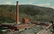
The St. Lawrence and Atlantic Railroad
(later the Grand Trunk Railway
) arrived in 1851. Located halfway between Montreal
, Canada
and the seacoast, Gorham developed into a railroad town, with a major locomotive
yard and repair facility. With trains came tourists, and the Mount Madison House, Alpine House, Gorham House and Willis House opened. Crowds went from Boston and the seacoast to White Mountain Station, and from there to the Glen House in Pinkham Notch
and Mount Washington
. In 1861, travelers made the first trek up the Mount Washington Carriage Road, winding 8 miles (12.9 km) to the summit of the 6288 feet (1,916.6 m) mountain. "The Road to the Sky" was an engineering feat of its day, advertised as "the first man-made attraction in the United States." It would be renamed the Mount Washington Auto Road
, and remains popular today.
Railroads benefited local industries as well, hauling freight for mills run by water power from the Androscoggin River
. Logging flourished, with boards and building timber manufactured by the Libby and the Peabody lumber companies. That business would eventually decline, as would railroads. In 1973, the town's train depot
, built in 1907, was scheduled for demolition. The Gorham Historical Society saved the building, which now serves as a headquarters and museum. It features displays on area history, with a collection including locomotives, boxcars and a caboose
.
, the town has a total area of 32.3 square miles (83.7 km²), of which 31.9 sq mi (82.6 km²) is land and 0.4 sq mi (1 km²) is water, comprising 1.27% of the town. The town center (census-designated place
) has a total area of 0.9 sq mi (2.3 km²), of which approximately 0.9 sq mi (2.3 km²) is land and approximately 0.1 sq mi (0.258998811 km²) is water.
Gorham is drained by the Androscoggin
, Peabody
, and Moose
rivers. Gorham lies fully within the Androscoggin River watershed
.
The highest point in Gorham is along its western border, on a spur of Mount Madison
, where the elevation reaches 3030 feet (923.5 m) above sea level
. While Gorham itself is surrounded by larger mountains, a small prominent peak within the town is 2400 feet (731.5 m) high Pine Mountain.
of 2000, there were 2,895 people, 1,293 households, and 801 families residing in the town. The population density
was 90.7 people per square mile (35.0/km²). There were 1,482 housing units at an average density of 46.4 per square mile (17.9/km²). The racial makeup of the town was 97.34% White, 0.07% Black or African American
, 0.21% Native American, 1.21% Asian, 0.03% Pacific Islander, 0.14% from other races
, and 1.00% from two or more races. Hispanic or Latino of any race were 0.31% of the population.
There were 1,293 households out of which 26.6% had children under the age of 18 living with them, 51.7% were married couples
living together, 6.5% had a female householder with no husband present, and 38.0% were non-families. 33.0% of all households were made up of individuals and 17.9% had someone living alone who was 65 years of age or older. The average household size was 2.24 and the average family size was 2.84.
 In the town the population was spread out with 22.1% under the age of 18, 5.9% from 18 to 24, 27.9% from 25 to 44, 24.5% from 45 to 64, and 19.6% who were 65 years of age or older. The median age was 42 years. For every 100 females there were 97.2 males. For every 100 females age 18 and over, there were 94.8 males.
The median income for a household in the town was $32,250, and the median income for a family was $41,008. Males had a median income of $34,659 versus $20,278 for females. The per capita income
for the town was $16,649. About 3.9% of families and 7.0% of the population were below the poverty line, including 6.0% of those under age 18 and 10.7% of those age 65 or over.
of 2000, there were 1,773 people, 799 households, and 488 families residing in the town center, or census-designated place
(CDP). The population density
was 2,073.5 people per square mile (796.0/km²). There were 912 housing units at an average density of 1,066.6 per square mile (409.4/km²). The racial makeup of the CDP was 97.18% White, 0.06% Black or African American
, 0.17% Native American, 1.02% Asian, 0.23% from other races
, and 1.35% from two or more races. Hispanic or Latino of any race were 0.39% of the population.
There were 799 households out of which 24.9% had children under the age of 18 living with them, 50.6% were married couples
living together, 6.8% had a female householder with no husband present, and 38.9% were non-families. 33.3% of all households were made up of individuals and 16.1% had someone living alone who was 65 years of age or older. The average household size was 2.21 and the average family size was 2.81.
In the CDP the population was spread out with 21.2% under the age of 18, 6.8% from 18 to 24, 28.2% from 25 to 44, 24.8% from 45 to 64, and 19.1% who were 65 years of age or older. The median age was 41 years. For every 100 females there were 97.0 males. For every 100 females age 18 and over, there were 97.3 males.
The median income for a household in the CDP was $31,813, and the median income for a family was $39,400. Males had a median income of $32,217 versus $22,708 for females. The per capita income
for the CDP was $16,910. About 4.7% of families and 8.0% of the population were below the poverty line, including 9.8% of those under age 18 and 11.7% of those age 65 or over.
New England town
The New England town is the basic unit of local government in each of the six New England states. Without a direct counterpart in most other U.S. states, New England towns are conceptually similar to civil townships in other states, but are incorporated, possessing powers like cities in other...
in Coos County
Coos County, New Hampshire
-National protected areas:*Umbagog National Wildlife Refuge *Silvio O. Conte National Fish and Wildlife Refuge *White Mountain National Forest -Demographics:...
, New Hampshire
New Hampshire
New Hampshire is a state in the New England region of the northeastern United States of America. The state was named after the southern English county of Hampshire. It is bordered by Massachusetts to the south, Vermont to the west, Maine and the Atlantic Ocean to the east, and the Canadian...
, United States
United States
The United States of America is a federal constitutional republic comprising fifty states and a federal district...
. The population was 2,848 at the 2010 census. Gorham is located in the White Mountains
White Mountains (New Hampshire)
The White Mountains are a mountain range covering about a quarter of the state of New Hampshire and a small portion of western Maine in the United States. Part of the Appalachian Mountains, they are considered the most rugged mountains in New England...
, and parts of the White Mountain National Forest
White Mountain National Forest
The White Mountain National Forest is a federally-managed forest contained within the White Mountains in the northeastern United States. It was established in 1918 as a result of the Weeks Act of 1911; federal acquisition of land had already begun in 1914. It has a total area of...
are in the south and northwest. Moose Brook State Park is in the west. The town is crossed by the Appalachian Trail
Appalachian Trail
The Appalachian National Scenic Trail, generally known as the Appalachian Trail or simply the AT, is a marked hiking trail in the eastern United States extending between Springer Mountain in Georgia and Mount Katahdin in Maine. It is approximately long...
. Tourism is a principal business. It is part of the Berlin
Berlin, New Hampshire
Berlin is a city along the Androscoggin River in Coos County in northern New Hampshire, United States. The population was 10,051 at the 2010 census. It includes the village of Cascade. Located on the edge of the White Mountains, the city's boundaries extend into the White Mountain National Forest...
, NH–VT
Vermont
Vermont is a state in the New England region of the northeastern United States of America. The state ranks 43rd in land area, , and 45th in total area. Its population according to the 2010 census, 630,337, is the second smallest in the country, larger only than Wyoming. It is the only New England...
Micropolitan Statistical Area
Berlin micropolitan area
The Berlin Micropolitan Statistical Area is the core based statistical area centered on the urban cluster associated with the city Berlin, New Hampshire in the United States...
.
The primary settlement in Gorham, where 1,600 people resided at the 2010 census, is defined as the Gorham census-designated place
Census-designated place
A census-designated place is a concentration of population identified by the United States Census Bureau for statistical purposes. CDPs are delineated for each decennial census as the statistical counterparts of incorporated places such as cities, towns and villages...
and is located between the two intersections of US 2
U.S. Route 2
U.S. Route 2 is an east–west U.S. Highway spanning across the northern continental United States. US 2 consists of two segments connected by various roadways in southern Canada...
and NH 16
New Hampshire Route 16
New Hampshire Route 16 is a long north–south highway in the U.S. state of New Hampshire. Much of its length is close to the border with Maine. NH 16 is the main route from the Seacoast region north to the Lakes Region and the White Mountains. The section from Portsmouth to Milton is a...
, along the Androscoggin River
Androscoggin River
The Androscoggin River is a river in the U.S. states of Maine and New Hampshire, in northern New England. It is long and joins the Kennebec River at Merrymeeting Bay in Maine before its water empties into the Gulf of Maine on the Atlantic Ocean. Its drainage basin is in area...
.
History
The community was first chartered in 1770 by ColonialColony
In politics and history, a colony is a territory under the immediate political control of a state. For colonies in antiquity, city-states would often found their own colonies. Some colonies were historically countries, while others were territories without definite statehood from their inception....
Governor John Wentworth
John Wentworth (governor)
Sir John Wentworth, 1st Baronet was the British colonial governor of New Hampshire at the time of the American Revolution. He was later also Lieutenant-Governor of Nova Scotia.-Early life:...
as a part of Shelburne
Shelburne, New Hampshire
Shelburne is a town in Coos County, New Hampshire, United States. The population was 372 at the 2010 census. It is located in the White Mountains, and part of the White Mountain National Forest is in the south. Shelburne is home to Leadmine State Forest...
, called Shelburne Addition. Settled about 1805, for years it contained little more than rocky farms, small logging
Logging
Logging is the cutting, skidding, on-site processing, and loading of trees or logs onto trucks.In forestry, the term logging is sometimes used in a narrow sense concerning the logistics of moving wood from the stump to somewhere outside the forest, usually a sawmill or a lumber yard...
operations, and a few stores and stables. When incorporated in 1836, the town had only 150 inhabitants. It was named Gorham at the suggestion of Sylvester Davis, a resident from Gorham
Gorham, Maine
Gorham is a town in Cumberland County, Maine, United States. The population was 16,381 at the 2010 census. In addition to an urban village center known as Gorham Village or simply "the Village," the town also encompasses a number of smaller, unincorporated villages and hamlets with distinct...
, Maine
Maine
Maine is a state in the New England region of the northeastern United States, bordered by the Atlantic Ocean to the east and south, New Hampshire to the west, and the Canadian provinces of Quebec to the northwest and New Brunswick to the northeast. Maine is both the northernmost and easternmost...
, and a relative of the Gorham family which founded that town in 1764.
The St. Lawrence and Atlantic Railroad
St. Lawrence and Atlantic Railroad
The St. Lawrence and Atlantic Railroad , known as St-Laurent et Atlantique Quebec in Canada, is a short line railroad operating between Portland, Maine on the Atlantic Ocean and Montreal, Quebec on the St. Lawrence River. It crosses the Canada-U.S...
(later the Grand Trunk Railway
Grand Trunk Railway
The Grand Trunk Railway was a railway system which operated in the Canadian provinces of Quebec and Ontario, as well as the American states of Connecticut, Maine, Michigan, Massachusetts, New Hampshire, and Vermont. The railway was operated from headquarters in Montreal, Quebec; however, corporate...
) arrived in 1851. Located halfway between Montreal
Montreal
Montreal is a city in Canada. It is the largest city in the province of Quebec, the second-largest city in Canada and the seventh largest in North America...
, Canada
Canada
Canada is a North American country consisting of ten provinces and three territories. Located in the northern part of the continent, it extends from the Atlantic Ocean in the east to the Pacific Ocean in the west, and northward into the Arctic Ocean...
and the seacoast, Gorham developed into a railroad town, with a major locomotive
Locomotive
A locomotive is a railway vehicle that provides the motive power for a train. The word originates from the Latin loco – "from a place", ablative of locus, "place" + Medieval Latin motivus, "causing motion", and is a shortened form of the term locomotive engine, first used in the early 19th...
yard and repair facility. With trains came tourists, and the Mount Madison House, Alpine House, Gorham House and Willis House opened. Crowds went from Boston and the seacoast to White Mountain Station, and from there to the Glen House in Pinkham Notch
Pinkham Notch
Pinkham Notch is a mountain pass in the White Mountains of north-central New Hampshire, United States. The notch is a result of extensive erosion by the Laurentide ice sheet during the Wisconsinian ice age. Pinkham Notch was eroded into a glacial U-shaped valley whose walls are formed by the...
and Mount Washington
Mount Washington (New Hampshire)
Mount Washington is the highest peak in the Northeastern United States at , famous for dangerously erratic weather. For 76 years, a weather observatory on the summit held the record for the highest wind gust directly measured at the Earth's surface, , on the afternoon of April 12, 1934...
. In 1861, travelers made the first trek up the Mount Washington Carriage Road, winding 8 miles (12.9 km) to the summit of the 6288 feet (1,916.6 m) mountain. "The Road to the Sky" was an engineering feat of its day, advertised as "the first man-made attraction in the United States." It would be renamed the Mount Washington Auto Road
Mount Washington Auto Road
The Mount Washington Auto Road is a toll road that extends from New Hampshire Route 16 in Pinkham Notch to the summit of Mount Washington in the White Mountains of the U.S. state of New Hampshire. The road climbs from an altitude of at the bottom to at the top, an average gradient of 11.6%...
, and remains popular today.
Railroads benefited local industries as well, hauling freight for mills run by water power from the Androscoggin River
Androscoggin River
The Androscoggin River is a river in the U.S. states of Maine and New Hampshire, in northern New England. It is long and joins the Kennebec River at Merrymeeting Bay in Maine before its water empties into the Gulf of Maine on the Atlantic Ocean. Its drainage basin is in area...
. Logging flourished, with boards and building timber manufactured by the Libby and the Peabody lumber companies. That business would eventually decline, as would railroads. In 1973, the town's train depot
Train station
A train station, also called a railroad station or railway station and often shortened to just station,"Station" is commonly understood to mean "train station" unless otherwise qualified. This is evident from dictionary entries e.g...
, built in 1907, was scheduled for demolition. The Gorham Historical Society saved the building, which now serves as a headquarters and museum. It features displays on area history, with a collection including locomotives, boxcars and a caboose
Caboose
A caboose is a manned North American rail transport vehicle coupled at the end of a freight train. Although cabooses were once used on nearly every freight train, their use has declined and they are seldom seen on trains, except on locals and smaller railroads.-Function:The caboose provided the...
.
Geography
According to the United States Census BureauUnited States Census Bureau
The United States Census Bureau is the government agency that is responsible for the United States Census. It also gathers other national demographic and economic data...
, the town has a total area of 32.3 square miles (83.7 km²), of which 31.9 sq mi (82.6 km²) is land and 0.4 sq mi (1 km²) is water, comprising 1.27% of the town. The town center (census-designated place
Census-designated place
A census-designated place is a concentration of population identified by the United States Census Bureau for statistical purposes. CDPs are delineated for each decennial census as the statistical counterparts of incorporated places such as cities, towns and villages...
) has a total area of 0.9 sq mi (2.3 km²), of which approximately 0.9 sq mi (2.3 km²) is land and approximately 0.1 sq mi (0.258998811 km²) is water.
Gorham is drained by the Androscoggin
Androscoggin River
The Androscoggin River is a river in the U.S. states of Maine and New Hampshire, in northern New England. It is long and joins the Kennebec River at Merrymeeting Bay in Maine before its water empties into the Gulf of Maine on the Atlantic Ocean. Its drainage basin is in area...
, Peabody
Peabody River
The Peabody River is a 12.9 mile long river in the White Mountains of New Hampshire in the United States. It is a tributary of the Androscoggin River, which flows south and east into Maine, joining the Kennebec River near the Atlantic Ocean....
, and Moose
Moose River (New Hampshire)
The Moose River is an long stream in northern New Hampshire in the United States. It is a tributary of the Androscoggin River, which flows south and east into Maine, joining the Kennebec River near the Atlantic Ocean....
rivers. Gorham lies fully within the Androscoggin River watershed
Drainage basin
A drainage basin is an extent or an area of land where surface water from rain and melting snow or ice converges to a single point, usually the exit of the basin, where the waters join another waterbody, such as a river, lake, reservoir, estuary, wetland, sea, or ocean...
.
The highest point in Gorham is along its western border, on a spur of Mount Madison
Mount Madison
Mount Madison is a mountain in the Presidential Range of New Hampshire in the United States. It is named after the fourth U.S. President, James Madison....
, where the elevation reaches 3030 feet (923.5 m) above sea level
Sea level
Mean sea level is a measure of the average height of the ocean's surface ; used as a standard in reckoning land elevation...
. While Gorham itself is surrounded by larger mountains, a small prominent peak within the town is 2400 feet (731.5 m) high Pine Mountain.
Demographics
As of the censusCensus
A census is the procedure of systematically acquiring and recording information about the members of a given population. It is a regularly occurring and official count of a particular population. The term is used mostly in connection with national population and housing censuses; other common...
of 2000, there were 2,895 people, 1,293 households, and 801 families residing in the town. The population density
Population density
Population density is a measurement of population per unit area or unit volume. It is frequently applied to living organisms, and particularly to humans...
was 90.7 people per square mile (35.0/km²). There were 1,482 housing units at an average density of 46.4 per square mile (17.9/km²). The racial makeup of the town was 97.34% White, 0.07% Black or African American
Race (United States Census)
Race and ethnicity in the United States Census, as defined by the Federal Office of Management and Budget and the United States Census Bureau, are self-identification data items in which residents choose the race or races with which they most closely identify, and indicate whether or not they are...
, 0.21% Native American, 1.21% Asian, 0.03% Pacific Islander, 0.14% from other races
Race (United States Census)
Race and ethnicity in the United States Census, as defined by the Federal Office of Management and Budget and the United States Census Bureau, are self-identification data items in which residents choose the race or races with which they most closely identify, and indicate whether or not they are...
, and 1.00% from two or more races. Hispanic or Latino of any race were 0.31% of the population.
There were 1,293 households out of which 26.6% had children under the age of 18 living with them, 51.7% were married couples
Marriage
Marriage is a social union or legal contract between people that creates kinship. It is an institution in which interpersonal relationships, usually intimate and sexual, are acknowledged in a variety of ways, depending on the culture or subculture in which it is found...
living together, 6.5% had a female householder with no husband present, and 38.0% were non-families. 33.0% of all households were made up of individuals and 17.9% had someone living alone who was 65 years of age or older. The average household size was 2.24 and the average family size was 2.84.
The median income for a household in the town was $32,250, and the median income for a family was $41,008. Males had a median income of $34,659 versus $20,278 for females. The per capita income
Per capita income
Per capita income or income per person is a measure of mean income within an economic aggregate, such as a country or city. It is calculated by taking a measure of all sources of income in the aggregate and dividing it by the total population...
for the town was $16,649. About 3.9% of families and 7.0% of the population were below the poverty line, including 6.0% of those under age 18 and 10.7% of those age 65 or over.
Town center
As of the censusCensus
A census is the procedure of systematically acquiring and recording information about the members of a given population. It is a regularly occurring and official count of a particular population. The term is used mostly in connection with national population and housing censuses; other common...
of 2000, there were 1,773 people, 799 households, and 488 families residing in the town center, or census-designated place
Census-designated place
A census-designated place is a concentration of population identified by the United States Census Bureau for statistical purposes. CDPs are delineated for each decennial census as the statistical counterparts of incorporated places such as cities, towns and villages...
(CDP). The population density
Population density
Population density is a measurement of population per unit area or unit volume. It is frequently applied to living organisms, and particularly to humans...
was 2,073.5 people per square mile (796.0/km²). There were 912 housing units at an average density of 1,066.6 per square mile (409.4/km²). The racial makeup of the CDP was 97.18% White, 0.06% Black or African American
Race (United States Census)
Race and ethnicity in the United States Census, as defined by the Federal Office of Management and Budget and the United States Census Bureau, are self-identification data items in which residents choose the race or races with which they most closely identify, and indicate whether or not they are...
, 0.17% Native American, 1.02% Asian, 0.23% from other races
Race (United States Census)
Race and ethnicity in the United States Census, as defined by the Federal Office of Management and Budget and the United States Census Bureau, are self-identification data items in which residents choose the race or races with which they most closely identify, and indicate whether or not they are...
, and 1.35% from two or more races. Hispanic or Latino of any race were 0.39% of the population.
There were 799 households out of which 24.9% had children under the age of 18 living with them, 50.6% were married couples
Marriage
Marriage is a social union or legal contract between people that creates kinship. It is an institution in which interpersonal relationships, usually intimate and sexual, are acknowledged in a variety of ways, depending on the culture or subculture in which it is found...
living together, 6.8% had a female householder with no husband present, and 38.9% were non-families. 33.3% of all households were made up of individuals and 16.1% had someone living alone who was 65 years of age or older. The average household size was 2.21 and the average family size was 2.81.
In the CDP the population was spread out with 21.2% under the age of 18, 6.8% from 18 to 24, 28.2% from 25 to 44, 24.8% from 45 to 64, and 19.1% who were 65 years of age or older. The median age was 41 years. For every 100 females there were 97.0 males. For every 100 females age 18 and over, there were 97.3 males.
The median income for a household in the CDP was $31,813, and the median income for a family was $39,400. Males had a median income of $32,217 versus $22,708 for females. The per capita income
Per capita income
Per capita income or income per person is a measure of mean income within an economic aggregate, such as a country or city. It is calculated by taking a measure of all sources of income in the aggregate and dividing it by the total population...
for the CDP was $16,910. About 4.7% of families and 8.0% of the population were below the poverty line, including 9.8% of those under age 18 and 11.7% of those age 65 or over.
Sites of interest
- Gorham Historical Society and Railroad Museum
- Moose Brook State ParkMoose Brook State ParkMoose Brook State Park is a New Hampshire state park in Coos County, New Hampshire in the United States. The park occupies and sits at an elevation of...