

Global storm activity of 2006
Encyclopedia
Global storm
activity of 2006 profiles the major worldwide storms, including blizzards, ice storms, and other winter events, from January 1, 2006 to December 31, 2006. Winter storm
s are events in which the dominant varieties of precipitation
are forms that only occur at cold temperature
s, such as snow
or sleet
, or a rainstorm where ground temperatures are cold enough to allow ice
to form (i.e. freezing rain
). It may be marked by strong wind
, thunder
and lightning
(a thunderstorm
), heavy precipitation
, such as ice
(ice storm
), or wind transporting some substance through the atmosphere
(as in a dust storm
, snowstorm, hail
storm, etc.). Other major non winter events such as large dust storms, Hurricanes, cyclone
s, tornado
s, gale
s, flooding and rainstorms are also caused by such phenomena to a lesser or greater existent.
Very rarely, they may form in summer, though it would have to be an abnormally cold summer, such as the summer of 1816
in the Northeast United States of America. In many locations in the Northern Hemisphere, the most powerful winter storms usually occur in March and, in regions where temperatures are cold enough, April.
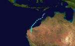 Severe Tropical Cyclone Clare
was a moderate strength cyclone
which hit Western Australia
in January 2006. The storm formed as an area of low pressure in the Arafura Sea
, on 4 January 2006, and moved westward. It ultimately peaked at Category 3 intensity on the Australian tropical cyclone scale. It moved ashore on the coast of Pilbara and proceeded inland, dissipating on 10 January. Clare produced winds of 142 km/h (88.2 mph) at Karratha and triggered widespread torrential rainfall that led to flooding. Following its usage, the name Clare was retired by the Bureau of Meteorology
, and will never be used again for a tropical cyclone in the area affected by it. Ahead of the storm's landfall, local and state officials issued a "red alert" for several locations along the storm's prdicted path. 2,000 people were evacuated in the Karratha region. In areas between Broome and Port Hedland, people were urged to tidy up debris and organise disaster supplies to prepare for the storm.
, several ports were closed and some oil rigs
were shut down at the time to. There were heavy floods in the affected region and parts of East Timor
to.
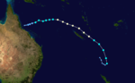 On 24 January, a broad area of low pressure developed near the coast of Queensland after a monsoonal trough passed through the region. Northeasterly winds flowing into the system quickly increased convection, resulting in heavy rainfall over coastal regions of Queensland. The slow movement of the developing low continued through 26 January before turning northeast in response to a mid-level ridge to the north. On 28 January, the JTWC began monitoring the system as Tropical Storm 10P and shortly after, the Bureau of Meteorology classified the storm as a Category 1 cyclone and gave it the name Jim. Torrential rainfall affected portions of coastal Queensland between 26 and 27 January. In a 24-hour span, 258 mm (10.2 in) of rain fell in Home Hill, leading to minor flooding. On 28 January, the cyclone brushed Flinders Reef
, New Caledonia
, Willis Island and Lihou Reef, bringing winds up to 65 km/h (40 mph) to all three areas.
in Australind, Western Australia
which is located 163 km south of Perth. Western Australia
n Bureau of Meteorology
measured the tornado to be a F2 on the Fujita scale
with the damage area measuring around 100m by 2000m.
. On the 13th the Battambang
, Pursat
and Kampong Thom were the first to be hit. The heavy rainfall started at evening time of 13 August in Kampong Speu Province and ended on the 14th. Kampot was flooded by heavy rain on the 16th along with five affected districts, 92 communes, 482 villages until the 17th. The Cambodian Red Cross Society gave help to the storm's victims. The storm burnt itself out over Thailand
and Laos
on the 29th. The Stung Sen River
and Mekong
river burst their banks.
The major storm-induced flood hit the Cambodia
n provinces of Kandal
, Koh Kong
, Kampot, Kampong Speu, Kampong Thom, Battambang
, Pursat
, Rattanakiri and the municipality of Phnom Penh
particularly badly, as were the Thai
provinces Amphoe Chiang Saen
and Chiang Rai Province
. Cambodian officials reported five deaths (two in Kampong Speu and 3 in Kampot). It was said that 252 homes had been flooded, 12 homes had been washed away and about 6,000 families had been evacuated from low-lying and coastal regions that were prone to flooding of this type. The Laotian town of Chiang Saen, Sekong Province
and Attapeu Province and Vientiane Prefecture were briefly flooded in places the 29th and 30th.
in Germany on the evening of August 21. Significant damage was reported in the area as it hit a campground. One person was killed and several others were injured as a result. It was the fourth tornado fatality in Europe in 2006.
and as far south as Utah
, and especially across the higher elevations of western Canada
. The snow did not affect any of the major cities in the area, but did affect travel. The snow also had a positive impact in that it significantly reduced the number of wildfire
s in the area.
Such heavy snowfall is not unusual in September, especially in the northern Rocky Mountains
.
 Another storm moved into the Rocky Mountain region, dropping 1–2 feet of snow throughout the mountains of Utah
, Wyoming
, and Colorado
. The Black Hills
near Deadwood, South Dakota
also saw up to a foot of snow. Gothic, Colorado and Alta, Utah
both reported 11 inches (279.4 mm).
. 43 provinces are flooded, with Chiang Mai Province
being the worst off. 1,000 were injured and approximately another 138,000 had been made ill by the polluted water supplies left after the storm had destroyed most of the water channes, seuwerage systems and water pipe lines. The Thai government estimate that 648000 acres (2,622.4 km²) of rice fields and farmland have been destroyed.
 A low pressure system moving through the Great Lakes
region, accompanied by a record-breaking cold snap, combined to produce significant early-season snowfall across the region. Several areas on the Lower Peninsula of Michigan
recorded their earliest-ever measurable snowfall, including 0.2" at Detroit on October 12, beating the old record from October 13, 1909, and 1–2 feet (30–60 cm) of snow fell over western portions of the Upper Peninsula. A foot of snow also fell across portions of southwestern Ontario in the Niagara region with significant amounts also recorded in northwestern Ontario north and west of Thunder Bay
.
Record-breaking snowfall of 1–2 feet also occurred in the highly localized lake effect snow
band areas around Buffalo, New York
, with Buffalo setting two consecutive daily October snowfall records, recording a total of 22.6 inches (57.4 cm). The resulting heavy, wet snow downed tree limbs and power lines, leaving 350,000 people without electricity
in western New York
. It also closed a large section of Interstate 90
from Rochester
to Dunkirk and killed three people. Governor
George Pataki
declared a state of emergency
in the hard-hit counties. The bands were very localized; very little snow fell in most other areas.
 The first Plains blizzard of the season occurred over the Front Range
of Colorado
. Blizzard warnings were issued, with 6 to 12 inches (15 to 30 cm) of snow combining with winds as strong as 60 mph (95 km/h) in some areas. Snow accumulations in the mountains reached up to 2 feet (60 cm). Dozens of school district
s were closed and highway
s were blocked throughout the region. Most flights out of Denver International Airport
were either canceled or significantly delayed.
Significant amounts of snow were also reported across northeastern Ontario
and western and central Quebec
from October 26 to October 30. Accumulations exceeded locally 20 centimetres (8 inches).
area received a Pineapple Express
that dumped several inches of rain over the area in a period of four days caused massive flooding, two deaths, and extensive damage to Mount Rainier National Park
. The rain contributed significantly towards making November 2006 the wettest on record for Seattle.
dumped heavy snow across parts of Minnesota
, Wisconsin
and the Upper Peninsula of Michigan
. The highest amounts were in western Wisconsin, east of the Twin Cities, where up to 16 inches (41 cm) of snow fell. Schools and roads were closed as a result. Portions of Northeastern Ontario
, including Greater Sudbury, also received over 15 centimetres on the night of the 10th into the 11th, with moderate snow falling across central Quebec
later that day.
took place in parts of South Carolina
and Georgia
in areas that typically don't receive snow, especially in November. The storm produced thunder snow for a time at Charleston, South Carolina
, the only time thunder snow has been reported. Generally 1–2 inches was observed in interior areas from Jenkins County, Georgia
to Colleton County, South Carolina. Not only was this a winter weather oddity, it was record setting. Charleston and Savannah, Georgia
both observed their earliest snowfall on record. The powerful storm also brought heavy rains, severe beach erosion, and damaging winds to South Carolina and Georgia. This storm also brought snow flurries as far south as central Florida
, near Orlando
, the earliest that snow had ever been recorded that far south.
in the last week of November. It produced a variety of severe weather, including heavy snow
, rain
, freezing rain
, sleet
, high wind
s, extreme cold, a serial derecho
and several tornado
es.
The most severe impacts were in the Midwest where several fatalities were reported and extensive power outages occurred.
region. The hardest hit community was London, Ontario
, where over 50 cm (20 inches) of snow fell. The heavy snow virtually shut down the community, with many roads and highways closed and even shutting down the transit system for the first time since 1978. Other areas on the leeward side of the Great Lakes saw lesser snowfall amounts.
causing significant damage and power outages, the highland areas saw blizzard conditions, along with hurricane-force winds. Some areas received over 16 inches (40 cm) of snow along with winds in excess of 80 mph (130 km/h). The blizzard also stalled rescue efforts on Mount Hood
.
and central Rocky Mountains
on December 19 and continued through December 21. The storm produced heavy snow across a large area covering six states centered around Denver, Colorado
. Areas in the foothills received up to 27 inches (68 cm) of snow, which closed many highways, including several Interstates. The area was crippled as a result, with schools and most businesses closed and the local transit system shut down. The heavy snow also closed Denver International Airport
as the Christmas
rush began.
Some areas expected up to 3 feet (90 cm) of snow. In addition, up to 7 inches (18 cm) fell as far south as New Mexico
. The Four Corners region saw up to 18 inches (45 cm) of snow in the mountains, with up to 6 inches (15 cm) in the valleys.
Governor
Bill Owens declared a state of emergency, which allowed state funds to be used to activate the Colorado National Guard
. Four people were killed by the storm.
including southern Jordan
which the area was paralysed due to heavy snow. Numerous roads leading to the area's main cities were shut down. The country's civil and defense teams had to rescue more than 1,400 who were trapped across various areas of the country. Air Force
helicopters also assisted in the rescue efforts. No fatalities were reported.
of Colorado
and adjacent Plains areas. Approximately 1–2 feet of snow fell along the Front Range, cancelling many flights and closing some roads, while up to 4 feet (1.2 m) fell in the surrounding foothills and mountains. At least a foot of snow, combined in some areas with up to 3 inches (76.2 mm) of freezing rain, fell from the Texas Panhandle
north along the High Plains
into South Dakota
. Ice fell all the way north into Ontario
, and from December 31 into January 1, ice fell in northern New England
before the storm weakened and exited the coast. The area around Albuquerque, New Mexico
saw 1–3 feet of snow, including a record one day snowfall of 11.3 inches (287 mm) on December 29. One area in the mountains of New Mexico saw an incredible 58 inches (4 feet, 10 inches). The storm overall brought 16.5 inches to Albuquerque, helping the city achieve its second-highest monthly snowfall total on record. Western Kansas saw up to 32 inches (812.8 mm) of snow, and a huge sweep of the central Plains for stranded travelers was undertaken in the days after the storm. 12 people were killed in the storm; 10 in traffic accidents across Colorado
, Texas
, and Minnesota
, 1 from a tornado in Texas
, where severe thunderstorms occurred, and 1 from carbon monoxide poisoning from a generator in western Kansas
.
Storm
A storm is any disturbed state of an astronomical body's atmosphere, especially affecting its surface, and strongly implying severe weather...
activity of 2006 profiles the major worldwide storms, including blizzards, ice storms, and other winter events, from January 1, 2006 to December 31, 2006. Winter storm
Winter storm
A winter storm is an event in which the dominant varieties of precipitation are formed that only occur at low temperatures, such as snow or sleet, or a rainstorm where ground temperatures are low enough to allow ice to form...
s are events in which the dominant varieties of precipitation
Precipitation (meteorology)
In meteorology, precipitation In meteorology, precipitation In meteorology, precipitation (also known as one of the classes of hydrometeors, which are atmospheric water phenomena is any product of the condensation of atmospheric water vapor that falls under gravity. The main forms of precipitation...
are forms that only occur at cold temperature
Temperature
Temperature is a physical property of matter that quantitatively expresses the common notions of hot and cold. Objects of low temperature are cold, while various degrees of higher temperatures are referred to as warm or hot...
s, such as snow
Snow
Snow is a form of precipitation within the Earth's atmosphere in the form of crystalline water ice, consisting of a multitude of snowflakes that fall from clouds. Since snow is composed of small ice particles, it is a granular material. It has an open and therefore soft structure, unless packed by...
or sleet
Rain and snow mixed
Rain and snow mixed is precipitation composed of rain and partially melted snow. This precipitation can occur where the temperature in the lower part of the atmosphere is slightly above the freezing point...
, or a rainstorm where ground temperatures are cold enough to allow ice
Ice
Ice is water frozen into the solid state. Usually ice is the phase known as ice Ih, which is the most abundant of the varying solid phases on the Earth's surface. It can appear transparent or opaque bluish-white color, depending on the presence of impurities or air inclusions...
to form (i.e. freezing rain
Freezing rain
Freezing rain is the name given to rain that falls when surface temperatures are below freezing. The raindrops become supercooled while passing through a sub-freezing layer of air, many hundred feet , just above the surface, and then freeze upon impact with any object they encounter. The resulting...
). It may be marked by strong wind
Wind
Wind is the flow of gases on a large scale. On Earth, wind consists of the bulk movement of air. In outer space, solar wind is the movement of gases or charged particles from the sun through space, while planetary wind is the outgassing of light chemical elements from a planet's atmosphere into space...
, thunder
Thunder
Thunder is the sound made by lightning. Depending on the nature of the lightning and distance of the listener, thunder can range from a sharp, loud crack to a long, low rumble . The sudden increase in pressure and temperature from lightning produces rapid expansion of the air surrounding and within...
and lightning
Lightning
Lightning is an atmospheric electrostatic discharge accompanied by thunder, which typically occurs during thunderstorms, and sometimes during volcanic eruptions or dust storms...
(a thunderstorm
Thunderstorm
A thunderstorm, also known as an electrical storm, a lightning storm, thundershower or simply a storm is a form of weather characterized by the presence of lightning and its acoustic effect on the Earth's atmosphere known as thunder. The meteorologically assigned cloud type associated with the...
), heavy precipitation
Precipitation (meteorology)
In meteorology, precipitation In meteorology, precipitation In meteorology, precipitation (also known as one of the classes of hydrometeors, which are atmospheric water phenomena is any product of the condensation of atmospheric water vapor that falls under gravity. The main forms of precipitation...
, such as ice
Ice
Ice is water frozen into the solid state. Usually ice is the phase known as ice Ih, which is the most abundant of the varying solid phases on the Earth's surface. It can appear transparent or opaque bluish-white color, depending on the presence of impurities or air inclusions...
(ice storm
Winter storm
A winter storm is an event in which the dominant varieties of precipitation are formed that only occur at low temperatures, such as snow or sleet, or a rainstorm where ground temperatures are low enough to allow ice to form...
), or wind transporting some substance through the atmosphere
Earth's atmosphere
The atmosphere of Earth is a layer of gases surrounding the planet Earth that is retained by Earth's gravity. The atmosphere protects life on Earth by absorbing ultraviolet solar radiation, warming the surface through heat retention , and reducing temperature extremes between day and night...
(as in a dust storm
Dust storm
A dust / sand storm is a meteorological phenomenon common in arid and semi-arid regions. Dust storms arise when a gust front or other strong wind blows loose sand and dirt from a dry surface. Particles are transported by saltation and suspension, causing soil to move from one place and deposition...
, snowstorm, hail
Hail
Hail is a form of solid precipitation. It consists of balls or irregular lumps of ice, each of which is referred to as a hail stone. Hail stones on Earth consist mostly of water ice and measure between and in diameter, with the larger stones coming from severe thunderstorms...
storm, etc.). Other major non winter events such as large dust storms, Hurricanes, cyclone
Cyclone
In meteorology, a cyclone is an area of closed, circular fluid motion rotating in the same direction as the Earth. This is usually characterized by inward spiraling winds that rotate anticlockwise in the Northern Hemisphere and clockwise in the Southern Hemisphere of the Earth. Most large-scale...
s, tornado
Tornado
A tornado is a violent, dangerous, rotating column of air that is in contact with both the surface of the earth and a cumulonimbus cloud or, in rare cases, the base of a cumulus cloud. They are often referred to as a twister or a cyclone, although the word cyclone is used in meteorology in a wider...
s, gale
Gale
A gale is a very strong wind. There are conflicting definitions of how strong a wind must be to be considered a gale. The U.S. government's National Weather Service defines a gale as 34–47 knots of sustained surface winds. Forecasters typically issue gale warnings when winds of this strength are...
s, flooding and rainstorms are also caused by such phenomena to a lesser or greater existent.
Very rarely, they may form in summer, though it would have to be an abnormally cold summer, such as the summer of 1816
Year Without a Summer
The Year Without a Summer was 1816, in which severe summer climate abnormalities caused average global temperatures to decrease by about 0.4–0.7 °C , resulting in major food shortages across the Northern Hemisphere...
in the Northeast United States of America. In many locations in the Northern Hemisphere, the most powerful winter storms usually occur in March and, in regions where temperatures are cold enough, April.
January
Cyclone Clare
Severe Tropical Cyclone Clare was a moderately strong cyclone that struck Western Australia in January 2006. The storm formed as an area of low pressure in the Arafura Sea, and moved westward. After receiving the name Clare on 7 January, the system ultimately peaked at Category 3 intensity on the...
was a moderate strength cyclone
Cyclone
In meteorology, a cyclone is an area of closed, circular fluid motion rotating in the same direction as the Earth. This is usually characterized by inward spiraling winds that rotate anticlockwise in the Northern Hemisphere and clockwise in the Southern Hemisphere of the Earth. Most large-scale...
which hit Western Australia
Western Australia
Western Australia is a state of Australia, occupying the entire western third of the Australian continent. It is bounded by the Indian Ocean to the north and west, the Great Australian Bight and Indian Ocean to the south, the Northern Territory to the north-east and South Australia to the south-east...
in January 2006. The storm formed as an area of low pressure in the Arafura Sea
Arafura Sea
The Arafura Sea lies west of the Pacific Ocean overlying the continental shelf between Australia and New Guinea.-Geography:The Arafura Sea is bordered by Torres Strait and through that the Coral Sea to the east, the Gulf of Carpentaria to the south, the Timor Sea to the west and the Banda and Ceram...
, on 4 January 2006, and moved westward. It ultimately peaked at Category 3 intensity on the Australian tropical cyclone scale. It moved ashore on the coast of Pilbara and proceeded inland, dissipating on 10 January. Clare produced winds of 142 km/h (88.2 mph) at Karratha and triggered widespread torrential rainfall that led to flooding. Following its usage, the name Clare was retired by the Bureau of Meteorology
Bureau of Meteorology
The Bureau of Meteorology is an Executive Agency of the Australian Government responsible for providing weather services to Australia and surrounding areas. It was established in 1906 under the Meteorology Act, and brought together the state meteorological services that existed before then...
, and will never be used again for a tropical cyclone in the area affected by it. Ahead of the storm's landfall, local and state officials issued a "red alert" for several locations along the storm's prdicted path. 2,000 people were evacuated in the Karratha region. In areas between Broome and Port Hedland, people were urged to tidy up debris and organise disaster supplies to prepare for the storm.
, several ports were closed and some oil rigs
Oil platform
An oil platform, also referred to as an offshore platform or, somewhat incorrectly, oil rig, is a lаrge structure with facilities to drill wells, to extract and process oil and natural gas, and to temporarily store product until it can be brought to shore for refining and marketing...
were shut down at the time to. There were heavy floods in the affected region and parts of East Timor
East Timor
The Democratic Republic of Timor-Leste, commonly known as East Timor , is a state in Southeast Asia. It comprises the eastern half of the island of Timor, the nearby islands of Atauro and Jaco, and Oecusse, an exclave on the northwestern side of the island, within Indonesian West Timor...
to.
Flinders Reef
Flinders Reef is a small isolated reef near Moreton Island, 5 km north-west of Cape Moreton in South East Queensland. It has the highest number of coral species of any sub tropical reef system along Australia's east coast and is the nearest true coral reef to Brisbane. Flinders Reef is one of...
, New Caledonia
New Caledonia
New Caledonia is a special collectivity of France located in the southwest Pacific Ocean, east of Australia and about from Metropolitan France. The archipelago, part of the Melanesia subregion, includes the main island of Grande Terre, the Loyalty Islands, the Belep archipelago, the Isle of...
, Willis Island and Lihou Reef, bringing winds up to 65 km/h (40 mph) to all three areas.
February
The TCWC Brisbane issued a gale warning for a Tropical Low near the northern tip of Cape York Peninsula on February 22. The low moved in an easterly direction. It quickly strengthened and became Tropical Cyclone Kate on the same day. Kate moved eastwards and weakened into a tropical low on February 24. Coastal Queensland was badly hit. In the Shire of Noosa, six surfers sustained serious injuries after wading into turbulent waters. Waves up to 1.8 m (5.9 ft) tossed the six surfers, leaving them with injuries ranging from broken noses and fractured ankles to head wounds from surfboards.August 7
50 houses were damaged with 7 houses completely losing roofs and two people received minor injuries in the suburb of LeschenaultLeschenault, Western Australia
Leschenault is an outer suburb of Bunbury, Western Australia, and is located 16 km to the north-east. Its Local Government Area is the Shire of Harvey.-History:...
in Australind, Western Australia
Australind, Western Australia
Australind is a satellite town and outer northern suburb of Bunbury, Western Australia, and is located 12 km north-east of Bunbury's central business district. Its Local Government Area is the Shire of Harvey. At the 2006 census, Australind had a population of 8,717. -History:Prior to European...
which is located 163 km south of Perth. Western Australia
Western Australia
Western Australia is a state of Australia, occupying the entire western third of the Australian continent. It is bounded by the Indian Ocean to the north and west, the Great Australian Bight and Indian Ocean to the south, the Northern Territory to the north-east and South Australia to the south-east...
n Bureau of Meteorology
Bureau of Meteorology
The Bureau of Meteorology is an Executive Agency of the Australian Government responsible for providing weather services to Australia and surrounding areas. It was established in 1906 under the Meteorology Act, and brought together the state meteorological services that existed before then...
measured the tornado to be a F2 on the Fujita scale
Fujita scale
The Fujita scale , or Fujita-Pearson scale, is a scale for rating tornado intensity, based primarily on the damage tornadoes inflict on human-built structures and vegetation...
with the damage area measuring around 100m by 2000m.
August 13–29
Between 13 and 29 August, major storm-induced flood hit the CambodiaCambodia
Cambodia , officially known as the Kingdom of Cambodia, is a country located in the southern portion of the Indochina Peninsula in Southeast Asia...
. On the 13th the Battambang
Battambang
Battambang is the capital city of Battambang province in northwestern Cambodia.Battambang is the second-largest city in Cambodia with a population of over 250,000. Founded in the 11th century by the Khmer Empire, Battambang is well known for being the leading rice-producing province of the country...
, Pursat
Pursat
Pursat is the capital of Pursat Province, Cambodia. Its name derived from a type of tree.- Notes :...
and Kampong Thom were the first to be hit. The heavy rainfall started at evening time of 13 August in Kampong Speu Province and ended on the 14th. Kampot was flooded by heavy rain on the 16th along with five affected districts, 92 communes, 482 villages until the 17th. The Cambodian Red Cross Society gave help to the storm's victims. The storm burnt itself out over Thailand
Thailand
Thailand , officially the Kingdom of Thailand , formerly known as Siam , is a country located at the centre of the Indochina peninsula and Southeast Asia. It is bordered to the north by Burma and Laos, to the east by Laos and Cambodia, to the south by the Gulf of Thailand and Malaysia, and to the...
and Laos
Laos
Laos Lao: ສາທາລະນະລັດ ປະຊາທິປະໄຕ ປະຊາຊົນລາວ Sathalanalat Paxathipatai Paxaxon Lao, officially the Lao People's Democratic Republic, is a landlocked country in Southeast Asia, bordered by Burma and China to the northwest, Vietnam to the east, Cambodia to the south and Thailand to the west...
on the 29th. The Stung Sen River
Stung Sen River
Stung Sen River is a river in Cambodia. It is a major tributary of the Tonlé Sap....
and Mekong
Mekong
The Mekong is a river that runs through China, Burma, Laos, Thailand, Cambodia and Vietnam. It is the world's 10th-longest river and the 7th-longest in Asia. Its estimated length is , and it drains an area of , discharging of water annually....
river burst their banks.
The major storm-induced flood hit the Cambodia
Cambodia
Cambodia , officially known as the Kingdom of Cambodia, is a country located in the southern portion of the Indochina Peninsula in Southeast Asia...
n provinces of Kandal
Kandal Province
Kandal is a province of Cambodia. Its capital is Ta Khmao town . The province completely surrounds, but does not include, the national capital Phnom Penh...
, Koh Kong
Koh Kong Province
Koh Kong is a province of Cambodia. The name means "Kŏng Island Province". Its capital is Koh Kong.-Geography:The most south-western province of Cambodia, Koh Kong has a long undeveloped coastline and a mountainous, forested and largely inaccessible interior which embraces part of the Cardamom...
, Kampot, Kampong Speu, Kampong Thom, Battambang
Battambang
Battambang is the capital city of Battambang province in northwestern Cambodia.Battambang is the second-largest city in Cambodia with a population of over 250,000. Founded in the 11th century by the Khmer Empire, Battambang is well known for being the leading rice-producing province of the country...
, Pursat
Pursat
Pursat is the capital of Pursat Province, Cambodia. Its name derived from a type of tree.- Notes :...
, Rattanakiri and the municipality of Phnom Penh
Phnom Penh
Phnom Penh is the capital and largest city of Cambodia. Located on the banks of the Mekong River, Phnom Penh has been the national capital since the French colonized Cambodia, and has grown to become the nation's center of economic and industrial activities, as well as the center of security,...
particularly badly, as were the Thai
Thailand
Thailand , officially the Kingdom of Thailand , formerly known as Siam , is a country located at the centre of the Indochina peninsula and Southeast Asia. It is bordered to the north by Burma and Laos, to the east by Laos and Cambodia, to the south by the Gulf of Thailand and Malaysia, and to the...
provinces Amphoe Chiang Saen
Amphoe Chiang Saen
Chiang Saen is a district in the northern part of Chiang Rai Province, northern Thailand.-History:According to an ancient chronicle, the original city of Chiang Saen was built in 545 in an area called Yonok, by Tai migrants from the Chinese province of Yunnan, and was an important city of the...
and Chiang Rai Province
Chiang Rai Province
Chiang Rai is the northernmost province of Thailand. Neighbouring provinces are Phayao, Lampang and Chiang Mai. In the north it borders Shan State of Myanmar and Bokeo of Laos.-Geography:...
. Cambodian officials reported five deaths (two in Kampong Speu and 3 in Kampot). It was said that 252 homes had been flooded, 12 homes had been washed away and about 6,000 families had been evacuated from low-lying and coastal regions that were prone to flooding of this type. The Laotian town of Chiang Saen, Sekong Province
Sekong Province
Sekong is a province of Laos, located in the south-east of the country.-Geography:Sekong was created in 1984, when it was split off from Salavan Province. It is bordered by Vietnam to the east, Attapeu Province to the south, Salavanh Province to the north, and Champasak Province to the west...
and Attapeu Province and Vientiane Prefecture were briefly flooded in places the 29th and 30th.
August 21
An isolated, strong tornado was reported in RemagenRemagen
Remagen is a town in Germany in Rhineland-Palatinate, in the district of Ahrweiler. It is about a one hour drive from Cologne , just south of Bonn, the former West German capital. It is situated on the River Rhine. There is a ferry across the Rhine from Remagen every 10–15 minutes in the summer...
in Germany on the evening of August 21. Significant damage was reported in the area as it hit a campground. One person was killed and several others were injured as a result. It was the fourth tornado fatality in Europe in 2006.
September 14–16
While not a major event, the first widespread winter weather event took place in the higher elevations of the Northwestern United StatesNorthwestern United States
The Northwestern United States comprise the northwestern states up to the western Great Plains regions of the United States, and consistently include the states of Oregon, Washington, Idaho, Montana, Wyoming, to which part of southeast Alaska is also sometimes included...
and as far south as Utah
Utah
Utah is a state in the Western United States. It was the 45th state to join the Union, on January 4, 1896. Approximately 80% of Utah's 2,763,885 people live along the Wasatch Front, centering on Salt Lake City. This leaves vast expanses of the state nearly uninhabited, making the population the...
, and especially across the higher elevations of western Canada
Canada
Canada is a North American country consisting of ten provinces and three territories. Located in the northern part of the continent, it extends from the Atlantic Ocean in the east to the Pacific Ocean in the west, and northward into the Arctic Ocean...
. The snow did not affect any of the major cities in the area, but did affect travel. The snow also had a positive impact in that it significantly reduced the number of wildfire
Wildfire
A wildfire is any uncontrolled fire in combustible vegetation that occurs in the countryside or a wilderness area. Other names such as brush fire, bushfire, forest fire, desert fire, grass fire, hill fire, squirrel fire, vegetation fire, veldfire, and wilkjjofire may be used to describe the same...
s in the area.
Such heavy snowfall is not unusual in September, especially in the northern Rocky Mountains
Rocky Mountains
The Rocky Mountains are a major mountain range in western North America. The Rocky Mountains stretch more than from the northernmost part of British Columbia, in western Canada, to New Mexico, in the southwestern United States...
.
September 21–23
Utah
Utah is a state in the Western United States. It was the 45th state to join the Union, on January 4, 1896. Approximately 80% of Utah's 2,763,885 people live along the Wasatch Front, centering on Salt Lake City. This leaves vast expanses of the state nearly uninhabited, making the population the...
, Wyoming
Wyoming
Wyoming is a state in the mountain region of the Western United States. The western two thirds of the state is covered mostly with the mountain ranges and rangelands in the foothills of the Eastern Rocky Mountains, while the eastern third of the state is high elevation prairie known as the High...
, and Colorado
Colorado
Colorado is a U.S. state that encompasses much of the Rocky Mountains as well as the northeastern portion of the Colorado Plateau and the western edge of the Great Plains...
. The Black Hills
Black Hills
The Black Hills are a small, isolated mountain range rising from the Great Plains of North America in western South Dakota and extending into Wyoming, USA. Set off from the main body of the Rocky Mountains, the region is something of a geological anomaly—accurately described as an "island of...
near Deadwood, South Dakota
Deadwood, South Dakota
Deadwood is a city in South Dakota, United States, and the county seat of Lawrence County. It is named for the dead trees found in its gulch. The population was 1,270 according to a 2010 census...
also saw up to a foot of snow. Gothic, Colorado and Alta, Utah
Alta, Utah
Alta is a town in Salt Lake County, Utah, United States. It is part of the Salt Lake City, Utah Metropolitan Statistical Area. The population was 370 at the 2000 census, a slight decrease from the 1990 figure of 397....
both reported 11 inches (279.4 mm).
October 9
On the 8th and 9th 32 died as a unusually heavy rain storm hits ThailandThailand
Thailand , officially the Kingdom of Thailand , formerly known as Siam , is a country located at the centre of the Indochina peninsula and Southeast Asia. It is bordered to the north by Burma and Laos, to the east by Laos and Cambodia, to the south by the Gulf of Thailand and Malaysia, and to the...
. 43 provinces are flooded, with Chiang Mai Province
Chiang Mai Province
Chiang Mai is the second-largest province of Thailand, located in the north of the country. Neighboring provinces are Chiang Rai, Lampang, Lamphun, Tak, and Mae Hong Son. In the north it borders Shan State of Burma...
being the worst off. 1,000 were injured and approximately another 138,000 had been made ill by the polluted water supplies left after the storm had destroyed most of the water channes, seuwerage systems and water pipe lines. The Thai government estimate that 648000 acres (2,622.4 km²) of rice fields and farmland have been destroyed.
October 11–13
Great Lakes
The Great Lakes are a collection of freshwater lakes located in northeastern North America, on the Canada – United States border. Consisting of Lakes Superior, Michigan, Huron, Erie, and Ontario, they form the largest group of freshwater lakes on Earth by total surface, coming in second by volume...
region, accompanied by a record-breaking cold snap, combined to produce significant early-season snowfall across the region. Several areas on the Lower Peninsula of Michigan
Michigan
Michigan is a U.S. state located in the Great Lakes Region of the United States of America. The name Michigan is the French form of the Ojibwa word mishigamaa, meaning "large water" or "large lake"....
recorded their earliest-ever measurable snowfall, including 0.2" at Detroit on October 12, beating the old record from October 13, 1909, and 1–2 feet (30–60 cm) of snow fell over western portions of the Upper Peninsula. A foot of snow also fell across portions of southwestern Ontario in the Niagara region with significant amounts also recorded in northwestern Ontario north and west of Thunder Bay
Thunder Bay
-In Canada:Thunder Bay is the name of three places in the province of Ontario, Canada along Lake Superior:*Thunder Bay District, Ontario, a district in Northwestern Ontario*Thunder Bay, a city in Thunder Bay District*Thunder Bay, Unorganized, Ontario...
.
Record-breaking snowfall of 1–2 feet also occurred in the highly localized lake effect snow
Lake effect snow
Lake-effect snow is produced during cooler atmospheric conditions when cold winds move across long expanses of warmer lake water, providing energy and picking up water vapor which freezes and is deposited on the leeward shores...
band areas around Buffalo, New York
Buffalo, New York
Buffalo is the second most populous city in the state of New York, after New York City. Located in Western New York on the eastern shores of Lake Erie and at the head of the Niagara River across from Fort Erie, Ontario, Buffalo is the seat of Erie County and the principal city of the...
, with Buffalo setting two consecutive daily October snowfall records, recording a total of 22.6 inches (57.4 cm). The resulting heavy, wet snow downed tree limbs and power lines, leaving 350,000 people without electricity
Electricity
Electricity is a general term encompassing a variety of phenomena resulting from the presence and flow of electric charge. These include many easily recognizable phenomena, such as lightning, static electricity, and the flow of electrical current in an electrical wire...
in western New York
New York
New York is a state in the Northeastern region of the United States. It is the nation's third most populous state. New York is bordered by New Jersey and Pennsylvania to the south, and by Connecticut, Massachusetts and Vermont to the east...
. It also closed a large section of Interstate 90
Interstate 90
Interstate 90 is the longest Interstate Highway in the United States at . It is the northernmost coast-to-coast interstate, and parallels US 20 for the most part. Its western terminus is in Seattle, at Edgar Martinez Drive S. near Safeco Field and CenturyLink Field, and its eastern terminus is in...
from Rochester
Rochester, New York
Rochester is a city in Monroe County, New York, south of Lake Ontario in the United States. Known as The World's Image Centre, it was also once known as The Flour City, and more recently as The Flower City...
to Dunkirk and killed three people. Governor
Governor of New York
The Governor of the State of New York is the chief executive of the State of New York. The governor is the head of the executive branch of New York's state government and the commander-in-chief of the state's military and naval forces. The officeholder is afforded the courtesy title of His/Her...
George Pataki
George Pataki
George Elmer Pataki is an American politician who was the 53rd Governor of New York. A member of the Republican Party, Pataki served three consecutive four-year terms from January 1, 1995 until December 31, 2006.- Early life :...
declared a state of emergency
State of emergency
A state of emergency is a governmental declaration that may suspend some normal functions of the executive, legislative and judicial powers, alert citizens to change their normal behaviours, or order government agencies to implement emergency preparedness plans. It can also be used as a rationale...
in the hard-hit counties. The bands were very localized; very little snow fell in most other areas.
October 25–30
Front Range
The Front Range is a mountain range of the Southern Rocky Mountains of North America located in the north-central portion of the U.S. State of Colorado and southeastern portion of the U.S. State of Wyoming. It is the first mountain range encountered moving west along the 40th parallel north across...
of Colorado
Colorado
Colorado is a U.S. state that encompasses much of the Rocky Mountains as well as the northeastern portion of the Colorado Plateau and the western edge of the Great Plains...
. Blizzard warnings were issued, with 6 to 12 inches (15 to 30 cm) of snow combining with winds as strong as 60 mph (95 km/h) in some areas. Snow accumulations in the mountains reached up to 2 feet (60 cm). Dozens of school district
School district
School districts are a form of special-purpose district which serves to operate the local public primary and secondary schools.-United States:...
s were closed and highway
Highway
A highway is any public road. In American English, the term is common and almost always designates major roads. In British English, the term designates any road open to the public. Any interconnected set of highways can be variously referred to as a "highway system", a "highway network", or a...
s were blocked throughout the region. Most flights out of Denver International Airport
Denver International Airport
Denver International Airport , often referred to as DIA, is an airport in Denver, Colorado. By land size, at , it is the largest international airport in the United States, and the third largest international airport in the world after King Fahd International Airport and Montréal-Mirabel...
were either canceled or significantly delayed.
Significant amounts of snow were also reported across northeastern Ontario
Ontario
Ontario is a province of Canada, located in east-central Canada. It is Canada's most populous province and second largest in total area. It is home to the nation's most populous city, Toronto, and the nation's capital, Ottawa....
and western and central Quebec
Quebec
Quebec or is a province in east-central Canada. It is the only Canadian province with a predominantly French-speaking population and the only one whose sole official language is French at the provincial level....
from October 26 to October 30. Accumulations exceeded locally 20 centimetres (8 inches).
November 5–7
The Puget SoundPuget Sound
Puget Sound is a sound in the U.S. state of Washington. It is a complex estuarine system of interconnected marine waterways and basins, with one major and one minor connection to the Strait of Juan de Fuca and the Pacific Ocean — Admiralty Inlet being the major connection and...
area received a Pineapple Express
Pineapple Express
Pineapple Express is a non-technical term for a meteorological phenomenon characterized by a strong and persistent flow of atmospheric moisture and associated heavy rainfall from the waters adjacent to the Hawaiian Islands and extending to any location along the Pacific coast of North America...
that dumped several inches of rain over the area in a period of four days caused massive flooding, two deaths, and extensive damage to Mount Rainier National Park
Mount Rainier National Park
Mount Rainier National Park is a United States National Park located in southeast Pierce County and northeast Lewis County in Washington state. It was one of the US's earliest National Parks, having been established on March 2, 1899 as the fifth national park in the United States. The park contains...
. The rain contributed significantly towards making November 2006 the wettest on record for Seattle.
November 9–11
The first major winter storm of the season in the Upper MidwestUpper Midwest
The Upper Midwest is a region in the northern portion of the U.S. Census Bureau's Midwestern United States. It is largely a sub-region of the midwest. Although there are no uniformly agreed-upon boundaries, the region is most commonly used to refer to the states of Minnesota, Wisconsin, and...
dumped heavy snow across parts of Minnesota
Minnesota
Minnesota is a U.S. state located in the Midwestern United States. The twelfth largest state of the U.S., it is the twenty-first most populous, with 5.3 million residents. Minnesota was carved out of the eastern half of the Minnesota Territory and admitted to the Union as the thirty-second state...
, Wisconsin
Wisconsin
Wisconsin is a U.S. state located in the north-central United States and is part of the Midwest. It is bordered by Minnesota to the west, Iowa to the southwest, Illinois to the south, Lake Michigan to the east, Michigan to the northeast, and Lake Superior to the north. Wisconsin's capital is...
and the Upper Peninsula of Michigan
Upper Peninsula of Michigan
The Upper Peninsula of Michigan is the northern of the two major land masses that make up the U.S. state of Michigan. It is commonly referred to as the Upper Peninsula, the U.P., or Upper Michigan. It is also known as the land "above the Bridge" linking the two peninsulas. The peninsula is bounded...
. The highest amounts were in western Wisconsin, east of the Twin Cities, where up to 16 inches (41 cm) of snow fell. Schools and roads were closed as a result. Portions of Northeastern Ontario
Northeastern Ontario
Northeastern Ontario is the region within the Canadian province of Ontario which lies north and east of Lakes Superior and Huron.Northeastern Ontario consists of the districts of Algoma, Sudbury, Cochrane, Timiskaming, Nipissing and Manitoulin; and the single-tier municipality of Greater...
, including Greater Sudbury, also received over 15 centimetres on the night of the 10th into the 11th, with moderate snow falling across central Quebec
Quebec
Quebec or is a province in east-central Canada. It is the only Canadian province with a predominantly French-speaking population and the only one whose sole official language is French at the provincial level....
later that day.
November 21
An unusual snow eventLate November 2006 Nor'easter
The Late November 2006 Nor'easter was an extratropical cyclone that formed offshore the Southeast United States on November 20, bringing heavy rains, high winds, beach erosion, and coastal flooding to the Carolinas and southern New England...
took place in parts of South Carolina
South Carolina
South Carolina is a state in the Deep South of the United States that borders Georgia to the south, North Carolina to the north, and the Atlantic Ocean to the east. Originally part of the Province of Carolina, the Province of South Carolina was one of the 13 colonies that declared independence...
and Georgia
Georgia (U.S. state)
Georgia is a state located in the southeastern United States. It was established in 1732, the last of the original Thirteen Colonies. The state is named after King George II of Great Britain. Georgia was the fourth state to ratify the United States Constitution, on January 2, 1788...
in areas that typically don't receive snow, especially in November. The storm produced thunder snow for a time at Charleston, South Carolina
Charleston, South Carolina
Charleston is the second largest city in the U.S. state of South Carolina. It was made the county seat of Charleston County in 1901 when Charleston County was founded. The city's original name was Charles Towne in 1670, and it moved to its present location from a location on the west bank of the...
, the only time thunder snow has been reported. Generally 1–2 inches was observed in interior areas from Jenkins County, Georgia
Jenkins County, Georgia
Jenkins County is a county located in the U.S. state of Georgia. It was created on August 17, 1905. As of 2000, the population was 8,575. The 2007 Census Estimate shows a population of 8,595. The county seat is Millen.-Geography:...
to Colleton County, South Carolina. Not only was this a winter weather oddity, it was record setting. Charleston and Savannah, Georgia
Savannah, Georgia
Savannah is the largest city and the county seat of Chatham County, in the U.S. state of Georgia. Established in 1733, the city of Savannah was the colonial capital of the Province of Georgia and later the first state capital of Georgia. Today Savannah is an industrial center and an important...
both observed their earliest snowfall on record. The powerful storm also brought heavy rains, severe beach erosion, and damaging winds to South Carolina and Georgia. This storm also brought snow flurries as far south as central Florida
Florida
Florida is a state in the southeastern United States, located on the nation's Atlantic and Gulf coasts. It is bordered to the west by the Gulf of Mexico, to the north by Alabama and Georgia and to the east by the Atlantic Ocean. With a population of 18,801,310 as measured by the 2010 census, it...
, near Orlando
Orlando, Florida
Orlando is a city in the central region of the U.S. state of Florida. It is the county seat of Orange County, and the center of the Greater Orlando metropolitan area. According to the 2010 US Census, the city had a population of 238,300, making Orlando the 79th largest city in the United States...
, the earliest that snow had ever been recorded that far south.
November 26–December 1
A widespread and severe storm complex tracked across the entire northern and central parts of North AmericaNorth America
North America is a continent wholly within the Northern Hemisphere and almost wholly within the Western Hemisphere. It is also considered a northern subcontinent of the Americas...
in the last week of November. It produced a variety of severe weather, including heavy snow
Snow
Snow is a form of precipitation within the Earth's atmosphere in the form of crystalline water ice, consisting of a multitude of snowflakes that fall from clouds. Since snow is composed of small ice particles, it is a granular material. It has an open and therefore soft structure, unless packed by...
, rain
Rain
Rain is liquid precipitation, as opposed to non-liquid kinds of precipitation such as snow, hail and sleet. Rain requires the presence of a thick layer of the atmosphere to have temperatures above the melting point of water near and above the Earth's surface...
, freezing rain
Freezing rain
Freezing rain is the name given to rain that falls when surface temperatures are below freezing. The raindrops become supercooled while passing through a sub-freezing layer of air, many hundred feet , just above the surface, and then freeze upon impact with any object they encounter. The resulting...
, sleet
Ice storm
An ice storm is a type of winter storm characterized by freezing rain, also known as a glaze event or in some parts of the United States as a silver thaw. The U.S. National Weather Service defines an ice storm as a storm which results in the accumulation of at least of ice on exposed surfaces...
, high wind
Wind
Wind is the flow of gases on a large scale. On Earth, wind consists of the bulk movement of air. In outer space, solar wind is the movement of gases or charged particles from the sun through space, while planetary wind is the outgassing of light chemical elements from a planet's atmosphere into space...
s, extreme cold, a serial derecho
Derecho
A derecho is a widespread and long-lived, violent convectively induced straight-line windstorm that is associated with a fast-moving band of severe thunderstorms in the form of a squall line usually taking the form of a bow echo...
and several tornado
Tornado
A tornado is a violent, dangerous, rotating column of air that is in contact with both the surface of the earth and a cumulonimbus cloud or, in rare cases, the base of a cumulus cloud. They are often referred to as a twister or a cyclone, although the word cyclone is used in meteorology in a wider...
es.
The most severe impacts were in the Midwest where several fatalities were reported and extensive power outages occurred.
December 8
A severe, but localized, lake effect snow event took place in parts of the Great LakesGreat Lakes
The Great Lakes are a collection of freshwater lakes located in northeastern North America, on the Canada – United States border. Consisting of Lakes Superior, Michigan, Huron, Erie, and Ontario, they form the largest group of freshwater lakes on Earth by total surface, coming in second by volume...
region. The hardest hit community was London, Ontario
London, Ontario
London is a city in Southwestern Ontario, Canada, situated along the Quebec City – Windsor Corridor. The city has a population of 352,395, and the metropolitan area has a population of 457,720, according to the 2006 Canadian census; the metro population in 2009 was estimated at 489,274. The city...
, where over 50 cm (20 inches) of snow fell. The heavy snow virtually shut down the community, with many roads and highways closed and even shutting down the transit system for the first time since 1978. Other areas on the leeward side of the Great Lakes saw lesser snowfall amounts.
December 14–16
While a severe rain and wind event took place in the Pacific NorthwestPacific Northwest
The Pacific Northwest is a region in northwestern North America, bounded by the Pacific Ocean to the west and, loosely, by the Rocky Mountains on the east. Definitions of the region vary and there is no commonly agreed upon boundary, even among Pacific Northwesterners. A common concept of the...
causing significant damage and power outages, the highland areas saw blizzard conditions, along with hurricane-force winds. Some areas received over 16 inches (40 cm) of snow along with winds in excess of 80 mph (130 km/h). The blizzard also stalled rescue efforts on Mount Hood
Mount Hood
Mount Hood, called Wy'east by the Multnomah tribe, is a stratovolcano in the Cascade Volcanic Arc of northern Oregon. It was formed by a subduction zone and rests in the Pacific Northwest region of the United States...
.
December 18–21
Another major winter storm slammed into the High PlainsHigh Plains (United States)
The High Plains are a subregion of the Great Plains mostly in the Western United States, but also partly in the Midwest states of Nebraska, Kansas, and South Dakota, generally encompassing the western part of the Great Plains before the region reaches the Rocky Mountains...
and central Rocky Mountains
Rocky Mountains
The Rocky Mountains are a major mountain range in western North America. The Rocky Mountains stretch more than from the northernmost part of British Columbia, in western Canada, to New Mexico, in the southwestern United States...
on December 19 and continued through December 21. The storm produced heavy snow across a large area covering six states centered around Denver, Colorado
Denver, Colorado
The City and County of Denver is the capital and the most populous city of the U.S. state of Colorado. Denver is a consolidated city-county, located in the South Platte River Valley on the western edge of the High Plains just east of the Front Range of the Rocky Mountains...
. Areas in the foothills received up to 27 inches (68 cm) of snow, which closed many highways, including several Interstates. The area was crippled as a result, with schools and most businesses closed and the local transit system shut down. The heavy snow also closed Denver International Airport
Denver International Airport
Denver International Airport , often referred to as DIA, is an airport in Denver, Colorado. By land size, at , it is the largest international airport in the United States, and the third largest international airport in the world after King Fahd International Airport and Montréal-Mirabel...
as the Christmas
Christmas
Christmas or Christmas Day is an annual holiday generally celebrated on December 25 by billions of people around the world. It is a Christian feast that commemorates the birth of Jesus Christ, liturgically closing the Advent season and initiating the season of Christmastide, which lasts twelve days...
rush began.
Some areas expected up to 3 feet (90 cm) of snow. In addition, up to 7 inches (18 cm) fell as far south as New Mexico
New Mexico
New Mexico is a state located in the southwest and western regions of the United States. New Mexico is also usually considered one of the Mountain States. With a population density of 16 per square mile, New Mexico is the sixth-most sparsely inhabited U.S...
. The Four Corners region saw up to 18 inches (45 cm) of snow in the mountains, with up to 6 inches (15 cm) in the valleys.
Governor
Governor of Colorado
The Governor of Colorado is the head of the executive branch of Colorado's government and the commander-in-chief of the state's military forces. The governor has a duty to enforce state laws, and the power to either approve or veto bills passed by the Colorado General Assembly, to convene the...
Bill Owens declared a state of emergency, which allowed state funds to be used to activate the Colorado National Guard
United States National Guard
The National Guard of the United States is a reserve military force composed of state National Guard militia members or units under federally recognized active or inactive armed force service for the United States. Militia members are citizen soldiers, meaning they work part time for the National...
. Four people were killed by the storm.
December 26–27
A rare winter storm blanketed parts of the Middle EastMiddle East
The Middle East is a region that encompasses Western Asia and Northern Africa. It is often used as a synonym for Near East, in opposition to Far East...
including southern Jordan
Jordan
Jordan , officially the Hashemite Kingdom of Jordan , Al-Mamlaka al-Urduniyya al-Hashemiyya) is a kingdom on the East Bank of the River Jordan. The country borders Saudi Arabia to the east and south-east, Iraq to the north-east, Syria to the north and the West Bank and Israel to the west, sharing...
which the area was paralysed due to heavy snow. Numerous roads leading to the area's main cities were shut down. The country's civil and defense teams had to rescue more than 1,400 who were trapped across various areas of the country. Air Force
Air force
An air force, also known in some countries as an air army, is in the broadest sense, the national military organization that primarily conducts aerial warfare. More specifically, it is the branch of a nation's armed services that is responsible for aerial warfare as distinct from an army, navy or...
helicopters also assisted in the rescue efforts. No fatalities were reported.
December 28–January 1
Another massive blizzard hit the Front RangeFront Range
The Front Range is a mountain range of the Southern Rocky Mountains of North America located in the north-central portion of the U.S. State of Colorado and southeastern portion of the U.S. State of Wyoming. It is the first mountain range encountered moving west along the 40th parallel north across...
of Colorado
Colorado
Colorado is a U.S. state that encompasses much of the Rocky Mountains as well as the northeastern portion of the Colorado Plateau and the western edge of the Great Plains...
and adjacent Plains areas. Approximately 1–2 feet of snow fell along the Front Range, cancelling many flights and closing some roads, while up to 4 feet (1.2 m) fell in the surrounding foothills and mountains. At least a foot of snow, combined in some areas with up to 3 inches (76.2 mm) of freezing rain, fell from the Texas Panhandle
Texas Panhandle
The Texas Panhandle is a region of the U.S. state of Texas consisting of the northernmost 26 counties in the state. The panhandle is a rectangular area bordered by New Mexico to the west and Oklahoma to the north and east...
north along the High Plains
High Plains (United States)
The High Plains are a subregion of the Great Plains mostly in the Western United States, but also partly in the Midwest states of Nebraska, Kansas, and South Dakota, generally encompassing the western part of the Great Plains before the region reaches the Rocky Mountains...
into South Dakota
South Dakota
South Dakota is a state located in the Midwestern region of the United States. It is named after the Lakota and Dakota Sioux American Indian tribes. Once a part of Dakota Territory, South Dakota became a state on November 2, 1889. The state has an area of and an estimated population of just over...
. Ice fell all the way north into Ontario
Ontario
Ontario is a province of Canada, located in east-central Canada. It is Canada's most populous province and second largest in total area. It is home to the nation's most populous city, Toronto, and the nation's capital, Ottawa....
, and from December 31 into January 1, ice fell in northern New England
New England
New England is a region in the northeastern corner of the United States consisting of the six states of Maine, New Hampshire, Vermont, Massachusetts, Rhode Island, and Connecticut...
before the storm weakened and exited the coast. The area around Albuquerque, New Mexico
Albuquerque, New Mexico
Albuquerque is the largest city in the state of New Mexico, United States. It is the county seat of Bernalillo County and is situated in the central part of the state, straddling the Rio Grande. The city population was 545,852 as of the 2010 Census and ranks as the 32nd-largest city in the U.S. As...
saw 1–3 feet of snow, including a record one day snowfall of 11.3 inches (287 mm) on December 29. One area in the mountains of New Mexico saw an incredible 58 inches (4 feet, 10 inches). The storm overall brought 16.5 inches to Albuquerque, helping the city achieve its second-highest monthly snowfall total on record. Western Kansas saw up to 32 inches (812.8 mm) of snow, and a huge sweep of the central Plains for stranded travelers was undertaken in the days after the storm. 12 people were killed in the storm; 10 in traffic accidents across Colorado
Colorado
Colorado is a U.S. state that encompasses much of the Rocky Mountains as well as the northeastern portion of the Colorado Plateau and the western edge of the Great Plains...
, Texas
Texas
Texas is the second largest U.S. state by both area and population, and the largest state by area in the contiguous United States.The name, based on the Caddo word "Tejas" meaning "friends" or "allies", was applied by the Spanish to the Caddo themselves and to the region of their settlement in...
, and Minnesota
Minnesota
Minnesota is a U.S. state located in the Midwestern United States. The twelfth largest state of the U.S., it is the twenty-first most populous, with 5.3 million residents. Minnesota was carved out of the eastern half of the Minnesota Territory and admitted to the Union as the thirty-second state...
, 1 from a tornado in Texas
Texas
Texas is the second largest U.S. state by both area and population, and the largest state by area in the contiguous United States.The name, based on the Caddo word "Tejas" meaning "friends" or "allies", was applied by the Spanish to the Caddo themselves and to the region of their settlement in...
, where severe thunderstorms occurred, and 1 from carbon monoxide poisoning from a generator in western Kansas
Kansas
Kansas is a US state located in the Midwestern United States. It is named after the Kansas River which flows through it, which in turn was named after the Kansa Native American tribe, which inhabited the area. The tribe's name is often said to mean "people of the wind" or "people of the south...
.
See also
- Winter stormWinter stormA winter storm is an event in which the dominant varieties of precipitation are formed that only occur at low temperatures, such as snow or sleet, or a rainstorm where ground temperatures are low enough to allow ice to form...
- Winter storms of 2006–2007
- Lake Storm "Aphid"
- Late November 2006 Nor'easterLate November 2006 Nor'easterThe Late November 2006 Nor'easter was an extratropical cyclone that formed offshore the Southeast United States on November 20, bringing heavy rains, high winds, beach erosion, and coastal flooding to the Carolinas and southern New England...
- Madden-Julian oscillationMadden-Julian oscillationThe Madden–Julian oscillation ' is the largest element of the intraseasonal variability in the tropical atmosphere. It is a large-scale coupling between atmospheric circulation and tropical deep convection...
- 2006 West Africa floods
External links
- Current Watches and Warnings in Canada, courtesy of Environment Canada
- February 2007 Lake Effect Snowstorm
- "Summary of Lake Effect Snow Event over the Tug Hill February 3–12, 2007" – National Weather ServiceNational Weather ServiceThe National Weather Service , once known as the Weather Bureau, is one of the six scientific agencies that make up the National Oceanic and Atmospheric Administration of the United States government...
Buffalo office - List of NWS summaries of the March 1-2, 2007 winter storm event (courtesy of NWS Duluth)