
Sea of Azov
Encyclopedia
The Sea of Azov known in Classical Antiquity
Classical antiquity
Classical antiquity is a broad term for a long period of cultural history centered on the Mediterranean Sea, comprising the interlocking civilizations of ancient Greece and ancient Rome, collectively known as the Greco-Roman world...
as Lake Maeotis, is a sea on the south of Eastern Europe
Eastern Europe
Eastern Europe is the eastern part of Europe. The term has widely disparate geopolitical, geographical, cultural and socioeconomic readings, which makes it highly context-dependent and even volatile, and there are "almost as many definitions of Eastern Europe as there are scholars of the region"...
. It is linked by the narrow (about 4 km) Strait of Kerch
Strait of Kerch
The Kerch Strait connects the Black Sea and the Sea of Azov, separating the Kerch Peninsula in the west from the Taman Peninsula in the east. The strait is to wide and up to deep....
to the Black Sea
Black Sea
The Black Sea is bounded by Europe, Anatolia and the Caucasus and is ultimately connected to the Atlantic Ocean via the Mediterranean and the Aegean seas and various straits. The Bosphorus strait connects it to the Sea of Marmara, and the strait of the Dardanelles connects that sea to the Aegean...
to the south and is bounded on the north by Ukraine
Ukraine
Ukraine is a country in Eastern Europe. It has an area of 603,628 km², making it the second largest contiguous country on the European continent, after Russia...
mainland, on the east by Russia, and on the west by the Ukraine's Crimean Peninsula. The Don
Don River (Russia)
The Don River is one of the major rivers of Russia. It rises in the town of Novomoskovsk 60 kilometres southeast from Tula, southeast of Moscow, and flows for a distance of about 1,950 kilometres to the Sea of Azov....
and Kuban
Kuban River
The Kuban River is a river in Russia, in the North Caucasus region. It flows mostly through Krasnodar Krai but also in the Karachay-Cherkess Republic, Stavropol Krai and the Republic of Adygea....
are the major rivers that flow into it. The Sea of Azov is the shallowest sea in the world with the depth varying between 0.9 metres (3 ft) and 14 metres (45.9 ft). There is a constant outflow of water from the Sea of Azov to the Black Sea.
The sea is largely affected by the inflow of numerous rivers, which bring sand, silt
Silt
Silt is granular material of a size somewhere between sand and clay whose mineral origin is quartz and feldspar. Silt may occur as a soil or as suspended sediment in a surface water body...
, and shells, forming numerous bays, limans
Liman (landform)
Liman is a name for a lake, bay, or estuary formed at the mouth of a river where flow is blocked by a bar of sediments. Liman can be maritime or fluvial .The name is used for such features found along the western and northern coast of the Black Sea, as well as along...
, and narrow sandbanks called spits
Spit (landform)
A spit or sandspit is a deposition landform found off coasts. At one end, spits connect to land, and extend into the sea. A spit is a type of bar or beach that develops where a re-entrant occurs, such as at cove's headlands, by the process of longshore drift...
. Because of these deposits, the sea bottom is relatively smooth and flat with the depth gradually increasing toward the sea centre. Also, due to the river inflow, water in the sea has low salinity and high content of biological matter, such as green algae
Green algae
The green algae are the large group of algae from which the embryophytes emerged. As such, they form a paraphyletic group, although the group including both green algae and embryophytes is monophyletic...
that affects the water colour. Abundant plankton results in unusually high fish productivity. The sea shores and spits are low; they are rich in vegetation and bird colonies.
Extent and juridical status
The International Hydrographic OrganizationInternational Hydrographic Organization
The International Hydrographic Organization is the inter-governmental organisation representing the hydrographic community. It enjoys observer status at the UN and is the recognised competent authority on hydrographic surveying and nautical charting...
defines the limit of the Sea of Azov in the Kertch Strait
Strait of Kerch
The Kerch Strait connects the Black Sea and the Sea of Azov, separating the Kerch Peninsula in the west from the Taman Peninsula in the east. The strait is to wide and up to deep....
as "The limit of the Black Sea
Black Sea
The Black Sea is bounded by Europe, Anatolia and the Caucasus and is ultimately connected to the Atlantic Ocean via the Mediterranean and the Aegean seas and various straits. The Bosphorus strait connects it to the Sea of Marmara, and the strait of the Dardanelles connects that sea to the Aegean...
", which is itself defined as "A line joining Cape Takil and Cape Panaghia (45°02'N)".
The sea is considered an internal sea of Russia and Ukraine, and its use is governed by an agreement between these countries ratified in 2003.
Geology and bathymetry
The sea is 360 kilometres (223.7 mi) long and 180 kilometres (111.8 mi) wide and has an area of 39000 square kilometres (15,058 sq mi); it is the smallest sea within the countries of the former Soviet Union. The main rivers flowing into it are the Don and KubanKuban River
The Kuban River is a river in Russia, in the North Caucasus region. It flows mostly through Krasnodar Krai but also in the Karachay-Cherkess Republic, Stavropol Krai and the Republic of Adygea....
; they ensure that the waters of the sea have comparatively low salinity and are almost fresh in places, and also bring in huge volumes of silt
Silt
Silt is granular material of a size somewhere between sand and clay whose mineral origin is quartz and feldspar. Silt may occur as a soil or as suspended sediment in a surface water body...
and sand. Accumulation of sand and shells results in a smooth and low coastline, as well as in numerous spits and sandbanks.
The Sea of Azov is the shallowest sea in the world with an average depth of 7 metres (23 ft) and maximum depth of 14 metres (45.9 ft); in the bays, where silt has built up, the average depth is about 1 metres (3 ft). The sea bottom is also relatively flat with the depth gradually increasing from the coast to the centre. The Sea of Azov is an internal sea with the passage to the Atlantic Ocean going through the Black, Marmara
Sea of Marmara
The Sea of Marmara , also known as the Sea of Marmora or the Marmara Sea, and in the context of classical antiquity as the Propontis , is the inland sea that connects the Black Sea to the Aegean Sea, thus separating Turkey's Asian and European parts. The Bosphorus strait connects it to the Black...
, Aegean
Aegean Sea
The Aegean Sea[p] is an elongated embayment of the Mediterranean Sea located between the southern Balkan and Anatolian peninsulas, i.e., between the mainlands of Greece and Turkey. In the north, it is connected to the Marmara Sea and Black Sea by the Dardanelles and Bosporus...
and Mediterranean seas. It is connected to the Black Sea with the Strait of Kerch, which has a smallest width of 4 kilometres (2.5 mi) and a maximum depth of 15 metres (49 ft). The narrowness of the Kerch Strait limits the water exchange with the Black Sea. As a result, the salinity of the Sea of Azov is low; in the open sea it is 10–12 psu, that is about one third of the salinity the oceans, and is even lower (2–7 psu) in the Taganrog Bay. The long-term variations of salinity are within a few psu and are mostly caused by the changes in air humidity and precipitation.
Whereas more than 20 rivers flow into the sea, mostly from the north, two of them, the Don
Don River (Russia)
The Don River is one of the major rivers of Russia. It rises in the town of Novomoskovsk 60 kilometres southeast from Tula, southeast of Moscow, and flows for a distance of about 1,950 kilometres to the Sea of Azov....
and Kuban
Kuban River
The Kuban River is a river in Russia, in the North Caucasus region. It flows mostly through Krasnodar Krai but also in the Karachay-Cherkess Republic, Stavropol Krai and the Republic of Adygea....
rivers, account for more than 90% of water income. The contribution of the Don is about twice as big as that of the Kuban. The delta of Kuban is located southeast, to the right from the Kerch Strait. It is over 100 km long and covers vast flooded area with numerous channels. (Because of the spread, the delta has low contrast in satellite images and is hardly visible in the map.) Don flows from the north into the large Taganrog Bay
Taganrog Bay
Taganrog Bay or Taganrog Gulf is the northeastern arm of the Sea of Azov. At its northeast end is the mouth of the Don River. Length: about 140 km, width at the mouth: 31 km, median depth: about 5 m. It may freeze some winters from December to March.Its mouth is marked by the...
. The depth there varies between 2 and 9 metres, and the maximum depth is observed in the middle of the sea.
Typical values of the yearly inflow and outflow of water to the sea, averaged over the period from 1923 to 1985, are as follows: river inflow 38.6 km3, precipitation 15.5 km3, evaporation 34.6 km3, inflow from the Black Sea 36–38 km3, outflow 53–55 km3. Thus, about 17 km3 of fresh water is outflowing from the Azov Sea to the Black Sea. The depth of Azov Sea is decreasing, mostly due to the river-induced deposits. Whereas the past hydrological expeditions recorded depths up to of 16 metres, more recent ones could not find places deeper than 13.5–14 metres. This might explain the variation in the maximum depths among different sources. The water level fluctuates by some 20 cm over the year due to the snow melts in spring.
The Taman Peninsula
Taman peninsula
The Taman Peninsula is a peninsula in the present-day Krasnodar Krai of Russia. It is bounded on the north by the Sea of Azov, on the west by the Strait of Kerch and on the south by the Black Sea. The peninsula has evolved over the past two millennia from a chain of islands into the peninsula it is...
has about 25 mud volcano
Mud volcano
The term mud volcano or mud dome are used to refer to formations created by geo-excreted liquids and gases, although there are several different processes which may cause such activity. Hot water mixes with mud and surface deposits. Mud volcanoes are associated with subduction zones and about 700...
es, most of which are active. Their eruptions are usually quiet, spilling out mud, and such gases as methane, carbon dioxide and hydrogen sulfide, but is sometimes violent and resembles regular volcanic eruptions. Some of those volcanoes are under water, near the shores of the peninsula. A major eruption on 6 September 1799, near stanitsa
Stanitsa
Stanitsa is a village inside a Cossack host . Stanitsas were the primary unit of Cossack hosts.Historically, the stanitsa was a unit of economic and political organisation of the Cossack peoples primarily in the southern regions of the Russian Empire.Much of the land was held in common by the...
Golubitskaya, lasted about 2 hours and formed a mud island 100 metres in diameter and 2 metres in height; the island was then washed away by the sea. Similar eruptions occurred in 1862, 1906, 1924, 1950 and 1952.
Coastal features and major population centres
Many rivers flowing into the Sea of Azov form bayBay
A bay is an area of water mostly surrounded by land. Bays generally have calmer waters than the surrounding sea, due to the surrounding land blocking some waves and often reducing winds. Bays also exist as an inlet in a lake or pond. A large bay may be called a gulf, a sea, a sound, or a bight...
s, lagoon
Lagoon
A lagoon is a body of shallow sea water or brackish water separated from the sea by some form of barrier. The EU's habitat directive defines lagoons as "expanses of shallow coastal salt water, of varying salinity or water volume, wholly or partially separated from the sea by sand banks or shingle,...
s and limans
Liman (landform)
Liman is a name for a lake, bay, or estuary formed at the mouth of a river where flow is blocked by a bar of sediments. Liman can be maritime or fluvial .The name is used for such features found along the western and northern coast of the Black Sea, as well as along...
. The sand
Sand
Sand is a naturally occurring granular material composed of finely divided rock and mineral particles.The composition of sand is highly variable, depending on the local rock sources and conditions, but the most common constituent of sand in inland continental settings and non-tropical coastal...
, silt
Silt
Silt is granular material of a size somewhere between sand and clay whose mineral origin is quartz and feldspar. Silt may occur as a soil or as suspended sediment in a surface water body...
and shell
Seashell
A seashell or sea shell, also known simply as a shell, is a hard, protective outer layer created by an animal that lives in the sea. The shell is part of the body of the animal. Empty seashells are often found washed up on beaches by beachcombers...
s they bring are deposited in the areas of reduced flow, that is the sides of the bays, forming narrow sandbanks called spits
Spit (landform)
A spit or sandspit is a deposition landform found off coasts. At one end, spits connect to land, and extend into the sea. A spit is a type of bar or beach that develops where a re-entrant occurs, such as at cove's headlands, by the process of longshore drift...
. Typical maximum depth in the bays and limans is a few metres. Because of shallow waters and abundant rivers, the spits are remarkably long and numerous in the sea – the Arabat Spit
Arabat Spit
The Arabat Spit , also called Arabat Tongue, is a spit which separates a large, shallow and very salty system of lagoons named Sivash from the Sea of Azov. The spit is located between the town of Henichesk, Ukraine, on the north and the north-eastern shores of Crimea on the south. It is separated...
stretches over 112 kilometres (69.6 mi) and is one of the world's longest spits; three other spits, Fedotov Spit, Achuevsk Spit and Obitochna Spit, are longer than 30 km. Most spits stretch from north to south and their shape can significantly change over just several years.
A remarkable feature of the Sea of Azov is the large complex of shallow lagoons called Sivash. Their typical depth is only 0.5–1 metres with a maximum of 3 metres. They cover an area of 2560 square kilometres (988.4 sq mi) in the northeastern Crimea
Crimea
Crimea , or the Autonomous Republic of Crimea , is a sub-national unit, an autonomous republic, of Ukraine. It is located on the northern coast of the Black Sea, occupying a peninsula of the same name...
which is separated from the sea by the Arabatsk Spit. North to the spit lies the city of Henichesk
Henichesk
Henichesk is a port city along the Sea of Azov in the Kherson Oblast of southern Ukraine. Serving as the administrative center of the Henichesky Raion , the city itself is also designated as a separate raion within the oblast.-References:...
(population 22,500) and south to it is the Bay of Arabat
Bay of Arabat
-External links:*...
. Sivash accepts up to 1.5 km3 of Azov water per year. Because of the large and shallow geometry, the water rapidly evaporates there, resulting in the high salinity of 170 on the practical salinity scale
Salinity
Salinity is the saltiness or dissolved salt content of a body of water. It is a general term used to describe the levels of different salts such as sodium chloride, magnesium and calcium sulfates, and bicarbonates...
(i.e. 170 psu). Therefore, Sivash has long had strong salt-producing industry.
North to the Arabat Spit there is the Molochna Liman with the associated Fedotov Spit (45 km long) which are formed by the Molochna River. Farther north, between the Fedotov Spit and Obytochna Spit (30 km long), lies Obytochny Bay. More to the north, between Obytochna Spit and Berdyansk Spit (23 km long), there is Berdyansk Bay with two cities Berdyansk (population 112,000) and Primorsk
Primorsk
Primorsk may refer to:*Dənizkənarı, Azerbaijan - formerly Primorsk*Primorsk, Leningrad Oblast, a town in Leningrad Oblast, Russia, formerly Koivisto or Björkö...
(population 13,900). Further north lies Belosaraysk Bay with its Belosaraysk Spit which are formed by the river Kalmius
Kalmius
The Kalmius is one of two rivers flowing through the Ukrainian city of Mariupol. The other river called the Kalchik flows into the Kalmius. The Kalmius flows into the Sea of Azov near the Azovstal steel manufacturing combine....
. The major city in the area is Mariupol
Mariupol
Mariupol , formerly known as Zhdanov , is a port city in southeastern Ukraine. It is located on the coast of the Azov Sea, at the mouth of the Kalmius River. Mariupol is the largest city in Priazovye - a geographical region around Azov Sea, divided by Russia and Ukraine - and is also a popular sea...
(population 491,600). Then, approaching the Taganrog Bay
Taganrog Bay
Taganrog Bay or Taganrog Gulf is the northeastern arm of the Sea of Azov. At its northeast end is the mouth of the Don River. Length: about 140 km, width at the mouth: 31 km, median depth: about 5 m. It may freeze some winters from December to March.Its mouth is marked by the...
and very close to Taganrog
Taganrog
Taganrog is a seaport city in Rostov Oblast, Russia, located on the north shore of Taganrog Bay , several kilometers west of the mouth of the Don River. Population: -History of Taganrog:...
, there are the Mius Liman and Krivaya Spit formed by the Mius River
Mius River
Mius is a river in Eastern Europe that flows through Ukraine and Russia. It starts in the Donets Range of Donetsk Oblast and flows through Luhansk Oblast, Ukraine and Rostov Oblast, Russia into the Mius Firth of the Sea of Azov, west of Taganrog...
.
With the area of about 5600 square kilometres (2,162.2 sq mi), the Taganrog Bay
Taganrog Bay
Taganrog Bay or Taganrog Gulf is the northeastern arm of the Sea of Azov. At its northeast end is the mouth of the Don River. Length: about 140 km, width at the mouth: 31 km, median depth: about 5 m. It may freeze some winters from December to March.Its mouth is marked by the...
is the largest bay of the Sea of Azov. It is located in its north-western part and is bound by the Belosaraysk and Dolgaya spit
Dolgaya Spit
The Dolgaya Spit is a sandy spit in the Sea of Azov. Length is 17 km, the width is about 500 m. The spit is located in Yeysk District of Krasnodar Krai, Russia...
s. The Don
Don River
- Australia :* Don River , a tributary of the Fitzroy River * Don River in North Queensland* Don River - United Kingdom :* River Don, South Yorkshire, England...
flows into it from the north-east. On its shores stand the two principal cities of the Sea of Azov, Taganrog
Taganrog
Taganrog is a seaport city in Rostov Oblast, Russia, located on the north shore of Taganrog Bay , several kilometers west of the mouth of the Don River. Population: -History of Taganrog:...
(population 257,600) and Azov
Azov
-External links:** *...
(population 83,200). South-east of the bay is Yeysk Liman. It lies entirely on the continent, entering the Taganrog Bay through the Yeysk and Glafirovsk Spits, and is the mouth of Yeya River
Yeya River
Yeya is a river in Krasnodar Krai, Russia. It falls into the Yeya Firth of Taganrog Bay, Sea of Azov. Length: 311 km, basin area: 8,650 km2. It dries up in summer. A port town of Yeysk is located by the Yeya Firth at the neck of the Yeya Spit. The river then travels to other, smaller...
. Yeysk Spit is part of Yeysk
Yeysk
-External links:* *...
city which has a population of 87,500. It extends in the prominent Yeysk peninsula which is tipped on the north-west by the Dolgaya Spit
Dolgaya Spit
The Dolgaya Spit is a sandy spit in the Sea of Azov. Length is 17 km, the width is about 500 m. The spit is located in Yeysk District of Krasnodar Krai, Russia...
. South of it, also enclosed by the continent, lies Beisug Liman, which is restricted by the Yasensk Spit and is fed by the Beysug River
Beysug River
Beysug is a river in Krasnodar Krai of Russia. It is 243 km long, with a drainage basin of 5190 km². It flows into the Azov Sea through the Beysugsky Liman....
. South-west to the liman, the 31 km long Achuevsk Spit runs along the coastline. Between the Achuevsk spit and Beisug Liman stands Primorsko-Akhtarsk
Primorsko-Akhtarsk
Primorsko-Akhtarsk is a port town in Krasnodar Krai, Russia, located on the coast of the Sea of Azov, northwest of Krasnodar. Population: Founded in 1829 and town status was granted to it in 1949....
populated by 32,165 people.
On the south, the Sea of Azov is connected to the Black Sea via the Strait of Kerch
Strait of Kerch
The Kerch Strait connects the Black Sea and the Sea of Azov, separating the Kerch Peninsula in the west from the Taman Peninsula in the east. The strait is to wide and up to deep....
, which is bordered to the west by the Kerch peninsula on the Crimea
Crimea
Crimea , or the Autonomous Republic of Crimea , is a sub-national unit, an autonomous republic, of Ukraine. It is located on the northern coast of the Black Sea, occupying a peninsula of the same name...
, belonging to Ukraine and to the east by the Russian Taman peninsula in Krasnodar Kraj. The city of Kerch
Kerch
Kerch is a city on the Kerch Peninsula of eastern Crimea, an important industrial, transport and tourist centre of Ukraine. Kerch, founded 2600 years ago, is considered as one of the most ancient cities in Ukraine.-Ancient times:...
(population 151,300) is located on the Kerch peninsula, and the Taman peninsula contains the delta of the Kuban
Kuban River
The Kuban River is a river in Russia, in the North Caucasus region. It flows mostly through Krasnodar Krai but also in the Karachay-Cherkess Republic, Stavropol Krai and the Republic of Adygea....
, a major Russian river. The strait is 41 kilometres long and 4 to 15 kilometres wide. Its narrowest part lies on the Sea of Azov side, restricted by the Chushka Spit
Chushka Spit
Chushka is a long narrow peninsula, or sandy spit, in the northern part of the Strait of Kerch which extends from Cape Achilleion to the south-west in the direction of the Black Sea for almost 18 km....
which faces southwards in consequence of the outflow
Outflow
Outflow may refer to:*Capital outflow - an economic term describing capital flowing out of a particular economy.*Bipolar outflow in astronomy represents two continuous flows of gas from the poles of a star....
from the Azov to the Black Sea.
Climate
The sea is relatively small and practically completely surrounded by land. Therefore, its climate is continental, with cold winters and hot and dry summers. In autumn-winter, the weather is affected by the Siberian AnticycloneSiberian High
The Siberian High is a massive collection of cold or very cold dry air that accumulates on the Eurasian terrain for much of the year. It reaches its greatest size and strength in the winter, when the air temperature near the center of the high-pressure cell or anticyclone is often lower than...
which brings cold and dry air from Siberia
Siberia
Siberia is an extensive region constituting almost all of Northern Asia. Comprising the central and eastern portion of the Russian Federation, it was part of the Soviet Union from its beginning, as its predecessor states, the Tsardom of Russia and the Russian Empire, conquered it during the 16th...
with winds of 4–7 m/s, sometimes up to 15 m/s. Those winds may lower the winter temperatures from the usual −1 to −5 °C to below −30 °C. The mean mid-summer temperatures are 23–25 °C with a maximum of about 40 °C. Winds are weaker in summer, typically 3–5 m/s. Precipitation
Precipitation (meteorology)
In meteorology, precipitation In meteorology, precipitation In meteorology, precipitation (also known as one of the classes of hydrometeors, which are atmospheric water phenomena is any product of the condensation of atmospheric water vapor that falls under gravity. The main forms of precipitation...
varies between 312 and 528 mm/year and is 1.5–2 times larger in summer than in winter.
Average water temperatures are 0–1 °C in winter (2–3 °C in the Kerch Strait) and 24–25 °C in summer, with a maximum of about 28 °C in the open sea and above 30 °C near the shores. During the summer, the sea surface is usually slightly warmer than the air. Because of the shallow character of the sea, the temperature usually lowers by only about 1 °C with depth, but in cold winters, the difference can reach 5–7 °C.
The winds cause frequent storms, with the waves reaching 6 metres in the Taganrog Bay, 2–4 metres near the southern shores, and 1 metre in the Kerch Strait. In the open sea, their height is usually 1–2 metres, sometimes up to 3 metres. Winds also induce frequent seiche
Seiche
A seiche is a standing wave in an enclosed or partially enclosed body of water. Seiches and seiche-related phenomena have been observed on lakes, reservoirs, swimming pools, bays, harbors and seas...
s – standing wave
Standing wave
In physics, a standing wave – also known as a stationary wave – is a wave that remains in a constant position.This phenomenon can occur because the medium is moving in the opposite direction to the wave, or it can arise in a stationary medium as a result of interference between two waves traveling...
s with the spatial period of 20–50 cm which last from minutes to hours. Another consequence of the winds is water currents. The prevailing current is a counter-clockwise swirl due to the westerly and south-westerly winds. Their speed is typically less than 10 cm/s, but can reach 60–70 cm/s for 15–20 m/s winds. In the bays, the flow is largely controlled by the inflow of the rivers and is directed away from the shore. In the Kerch Strait, the flow is normally toward the Black Sea due to the predominance of northern winds and the water inflow from the rivers; its average speed is 10–20 cm/s, reaching 30–40 cm in the narrowest parts. Tides are variable but can peak at 5.5 metres.
The shallowness and low salinity
Salinity
Salinity is the saltiness or dissolved salt content of a body of water. It is a general term used to describe the levels of different salts such as sodium chloride, magnesium and calcium sulfates, and bicarbonates...
of the sea make it vulnerable to freezing during the winter. Fast ice
Fast ice
Fast ice is sea ice that has frozen along coasts along the shoals, or to the sea floor over shallow parts of the continental shelf, and extends out from land into sea. In Antarctica, fast ice may also extend between grounded icebergs...
bands ranging from 7 km in the north to 1.5 km in the south can occur temporarily at any time from late December to mid-March. Under the present climate the sea no longer freezes over, although during the 18th and 19th centuries, and as recently as in the late 1970s, it was normally frozen over every year by early February. The ice thickness reaches 30–40 cm in most parts of the sea and 60–80 cm in the Taganrog Bay. The ice is often unstable and piles up to the height of several metres. Before introduction of icebreaker
Icebreaker
An icebreaker is a special-purpose ship or boat designed to move and navigate through ice-covered waters. Although the term usually refers to ice-breaking ships, it may also refer to smaller vessels .For a ship to be considered an icebreaker, it requires three traits most...
s, navigation was halted in the winter.
Hydrology and hydrochemistry
The current vertical profile of the Sea of Azov exhibits oxygenated surface waters and anoxic bottom waters, with the anoxic waters forming in a layer 0.5 to 4 m (1.6 to 13.1 ft) in thickness. The occurrence of the anoxic layer is attributed to seasonal eutrophication events associated with increased sedimentary input from the Don and Kuban Rivers. This sedimentary input stimulates biotic activity in the surfaces layers, which photosynthesise under aerobic conditions. Once expired, the dead organic matter sinks to the bottom of the sea where bacteria and microorganisms, using all available oxygen, consume the organic matter, leading to anoxic conditions. Studies have shown that in the Sea of Azov, the exact vertical structure is dependent on wind strength and sea surface temperature, but typically a 'stagnation zone' lies between the oxic and anoxic layers.Flora and fauna
Historically, the sea has had rich marine life, both in variety, with over 80 fish and 300 invertebrate species identified, and in their numbers. Consequently, fishery has long been a major activity in the area. The annual catchment of recent years was 300,000 tonnes, about half of which are valuable species (sturgeons, pike-perchesSander (genus)
Sander is a genus of fish in the Percidae family. They are also known as "pike-perch" because of their resemblance to fish in the unrelated Esocidae family....
, breams, sea-roaches
Black Sea Roach
The Black Sea Roach is a species of ray-finned fish in the Cyprinidae family.It is found in Armenia, Azerbaijan, Bulgaria, Georgia, Iran, Kazakhstan, Moldova, Romania, Russia, Turkey, Turkmenistan, and Ukraine.-Source:...
, etc.). This was partly due to extremely high biological productivity of the sea, which was stimulated by the strong supply of nutrients from numerous rivers feeding the sea, low water salinity, ample heating due to shallow waters and long vegetation period. However, diversity and numbers have been reduced by artificial reduction of river flow (construction of dams), over-fishing and water-intense large-scale cultivation of cotton, causing increasing levels of pollution
Pollution
Pollution is the introduction of contaminants into a natural environment that causes instability, disorder, harm or discomfort to the ecosystem i.e. physical systems or living organisms. Pollution can take the form of chemical substances or energy, such as noise, heat or light...
. The fish hauls have rapidly decreased and in particular anchovy
Anchovy
Anchovies are a family of small, common salt-water forage fish. There are 144 species in 17 genera, found in the Atlantic, Indian, and Pacific Oceans. Anchovies are usually classified as an oily fish.-Description:...
fisheries have collapsed.
Plankton and benthos
Because of shallow waters, the development of aquatic life in the Sea of Azov is more characteristic of a lagoon, and the plankton patterns are rather similar in the open sea and near the shores. However, despite shallowness, water has low transparency. Therefore, the bottom plants are poorly developed and most algae are of planktonic type. The sea is characterised by high concentration of organic matter and long blooming periods. Another specific feature of the sea is variable salinity – low in the large bays and higher in the open sea, especially near the Kerch Strait. Therefore, the plankton species are distributed inhomogeneously in the Sea of Azov. Although many additional species are brought from the salty Black Sea, most of them can not adjust to the variable salinity of the Sea of Azov, except for the euryhalineEuryhaline
Euryhaline organisms are able to adapt to a wide range of salinities. An example of a euryhaline fish is the molly which can live in fresh, brackish, or salt water. The European shore crab is an example of a euryhaline invertebrate that can live in salt and brackish water...
species. About 600 species of planktonic algae are known in the Sea of Azov. The number of species is dominated by diatom
Diatom
Diatoms are a major group of algae, and are one of the most common types of phytoplankton. Most diatoms are unicellular, although they can exist as colonies in the shape of filaments or ribbons , fans , zigzags , or stellate colonies . Diatoms are producers within the food chain...
s and green algae
Green algae
The green algae are the large group of algae from which the embryophytes emerged. As such, they form a paraphyletic group, although the group including both green algae and embryophytes is monophyletic...
; blue-green algae and pyrophites are significant, and euglena
Euglena
Euglena is a genus of unicellular flagellate protists. It is the best known and most widely studied member of the phylum Euglenozoa , a diverse group containing some 44 genera and at least 800 species. Species of Euglena are found in fresh and salt waters...
and yellow-green algae
Yellow-green algae
Yellow-green algae or xanthophytes are an important group of heterokont algae. Most live in freshwater, but some are found in marine and soil habitats. They vary from single-celled flagellates to simple colonial and filamentous forms. Xanthophyte chloroplasts contain the photosynthetic pigments...
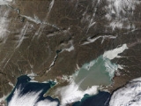
form only 5% of the species. Green algae are mostly responsible for the colour of the sea in the satellite images (see photos above).
Regarding zooplankton
Zooplankton
Zooplankton are heterotrophic plankton. Plankton are organisms drifting in oceans, seas, and bodies of fresh water. The word "zooplankton" is derived from the Greek zoon , meaning "animal", and , meaning "wanderer" or "drifter"...
, freshwaters of the Tanganrog Bay are inhabited by cladocera
Cladocera
Cladocera is an order of small crustaceans commonly called water fleas. Around 620 species have been recognised so far, with many more undescribed. They are ubiquitous in inland aquatic habitats, but rare in the oceans. Most are long, with a down-turned head, and a carapace covering the apparently...
, copepod
Copepod
Copepods are a group of small crustaceans found in the sea and nearly every freshwater habitat. Some species are planktonic , some are benthic , and some continental species may live in limno-terrestrial habitats and other wet terrestrial places, such as swamps, under leaf fall in wet forests,...
a and rotifer
Rotifer
The rotifers make up a phylum of microscopic and near-microscopic pseudocoelomate animals. They were first described by Rev. John Harris in 1696, and other forms were described by Anton van Leeuwenhoek in 1703...
s, such as Brachionus plicatilis
Brachionus plicatilis
Brachionus plicatilis is a euryhaline rotifer in the Family Brachionidae, and is possibly the only commercially important rotifer, being raised in the aquaculture industry as food for fish larvae. It has a broad distribution in salt lakes around the world and has become a model system for studies...
, Keratella curdata and Asplanchna. Western part of the sea, which is more saline, hosts three forms of Acartia clausi
Acartia clausi
Acartia clausi is a species of marine copepod belonging to the family Acartiidae. This species was previously thought to have a worldwide distribution but recent research has restricted its range to coastal regions of the north-east Atlantic Ocean as far north as Iceland, the Mediterranean Sea and...
, as well as Centropages ponticus, meroplankton
Meroplankton
Meroplankton are organisms that are planktonic for only a part of their life cycles, usually the larval stage. Examples of meroplankton include the larvae of sea urchins, sea stars, crustaceans, marine worms, some marine gastropods and most fish....
and larvae of gastropoda
Gastropoda
The Gastropoda or gastropods, more commonly known as snails and slugs, are a large taxonomic class within the phylum Mollusca. The class Gastropoda includes snails and slugs of all kinds and all sizes from microscopic to quite large...
, bivalvia
Bivalvia
Bivalvia is a taxonomic class of marine and freshwater molluscs. This class includes clams, oysters, mussels, scallops, and many other families of molluscs that have two hinged shells...
and polychaete
Polychaete
The Polychaeta or polychaetes are a class of annelid worms, generally marine. Each body segment has a pair of fleshy protrusions called parapodia that bear many bristles, called chaetae, which are made of chitin. Indeed, polychaetes are sometimes referred to as bristle worms. More than 10,000...
.
Benthos
Benthos
Benthos is the community of organisms which live on, in, or near the seabed, also known as the benthic zone. This community lives in or near marine sedimentary environments, from tidal pools along the foreshore, out to the continental shelf, and then down to the abyssal depths.Many organisms...
species reside mostly at the sea bottom and include worms, crustacean
Crustacean
Crustaceans form a very large group of arthropods, usually treated as a subphylum, which includes such familiar animals as crabs, lobsters, crayfish, shrimp, krill and barnacles. The 50,000 described species range in size from Stygotantulus stocki at , to the Japanese spider crab with a leg span...
s, bottom protist
Protist
Protists are a diverse group of eukaryotic microorganisms. Historically, protists were treated as the kingdom Protista, which includes mostly unicellular organisms that do not fit into the other kingdoms, but this group is contested in modern taxonomy...
s, coelenterata
Coelenterata
Coelenterata is an obsolete term encompassing two animal phyla, the Ctenophora and the Cnidaria . The name comes from the Greek "koilos" , referring to the hollow body cavity common to these two phyla...
and mollusks
Mollusca
The Mollusca , common name molluscs or mollusksSpelled mollusks in the USA, see reasons given in Rosenberg's ; for the spelling mollusc see the reasons given by , is a large phylum of invertebrate animals. There are around 85,000 recognized extant species of molluscs. Mollusca is the largest...
. Mollusks account for 60–98% of the invertebrate biomass at the Sea of Azov bottom.

Fish
There are 183 ichthyofauna species from 112 genera and 55 families in the Sea of Azov region. Among them, there are 50 rare and 19 endangered species, and the sturgeon Acipenser nudiventrisBastard sturgeon
The bastard sturgeon, fringebarbel sturgeon, ship sturgeon, spiny sturgeon, or thorn sturgeon is a species of fish in the Acipenseridae family...
is probably extinct in the region.
The fauna of the freshwater Taganrog Bay is much poorer – it consists of 55 species from 36 general and 16 families; among them, three species are rare and 6 are endangered.
Flora

Estuary
An estuary is a partly enclosed coastal body of water with one or more rivers or streams flowing into it, and with a free connection to the open sea....
and marshes and are dominated by reeds, sedges
Cyperaceae
Cyperaceae are a family of monocotyledonous graminoid flowering plants known as sedges, which superficially resemble grasses or rushes. The family is large, with some 5,500 species described in about 109 genera. These species are widely distributed, with the centers of diversity for the group...
, Typha
Typha
Typha is a genus of about eleven species of monocotyledonous flowering plants in the family Typhaceae. The genus has a largely Northern Hemisphere distribution, but is essentially cosmopolitan, being found in a variety of wetland habitats...
and Sparganium
Sparganium
Sparganium is a genus of flowering plants, containing about 20 species in temperate regions of both the Northern and Southern Hemispheres. It was previously placed alone in the family Sparganiaceae...
. Typical submerged plants are Charales
Charales
Charales is an order of pondweeds, freshwater algae in the division Charophyta. They are green plants believed to be the closest relatives of the green land plants. Linnaeus established the genus Chara in 1753.-Description:...
, pond weed
Potamogeton
Potamogeton is a genus of aquatic, mostly freshwater, plants of the family Potamogetonaceae. Most are known by the common name pondweed, although many unrelated plants may be called pondweed, such as Canadian pondweed...
, hornworts
Ceratophyllum
Ceratophyllum is a cosmopolitan genus of flowering plants, commonly found in ponds, marshes, and quiet streams in tropical and in temperate regions...
and water lilies
Nymphaeaceae
Nymphaeaceae is a family of flowering plants. Members of this family are commonly called water lilies and live in freshwater areas in temperate and tropical climates around the world. The family contains eight genera. There are about 70 species of water lilies around the world. The genus...
. Also common is lotus
Nelumbo
Nelumbo is a genus of aquatic plants with large, showy flowers resembling water lilies, commonly known as lotus. The generic name is derived from the Sinhalese word Nelum. There are only two known living species in the genus. The sacred lotus is native to Asia, and is the better known of the two...
which was brought to the area from Africa. The number of species is large; for example, the Belosaraysk and Berdyansk spits alone contain more than 200 each. Some spits are declared national nature reserves, such as Beglitsk,
Belosaraysk, Krivaya and Berdyansk Spits.
Fauna
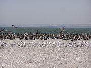
Great Cormorant
The Great Cormorant , known as the Great Black Cormorant across the Northern Hemisphere, the Black Cormorant in Australia and the Black Shag further south in New Zealand, is a widespread member of the cormorant family of seabirds...
and pelican
Pelican
A pelican, derived from the Greek word πελεκυς pelekys is a large water bird with a large throat pouch, belonging to the bird family Pelecanidae....
s are common. Also frequently observed are swans, herons, sandpipers and many birds of prey. Mammals include foxes, wild cats, hare, hedgehogs, weasel
Weasel
Weasels are mammals forming the genus Mustela of the Mustelidae family. They are small, active predators, long and slender with short legs....
s, marten
Marten
The martens constitute the genus Martes within the subfamily Mustelinae, in family Mustelidae.-Description:Martens are slender, agile animals, adapted to living in taigas, and are found in coniferous and northern deciduous forests across the northern hemisphere. They have bushy tails, and large...
s and wild boars. Muskrat
Muskrat
The muskrat , the only species in genus Ondatra, is a medium-sized semi-aquatic rodent native to North America, and introduced in parts of Europe, Asia, and South America. The muskrat is found in wetlands and is a very successful animal over a wide range of climates and habitats...
s were introduced to the area in the early 20th century and are hunted for their fur.
Migrating and invading species
Anchovy
Anchovies are a family of small, common salt-water forage fish. There are 144 species in 17 genera, found in the Atlantic, Indian, and Pacific Oceans. Anchovies are usually classified as an oily fish.-Description:...
, garfish
Garfish
The garfish , or sea needle, is a pelagic, oceanodromous needlefish found in brackish and marine waters of the Eastern Atlantic, the Mediterranean Sea, the Baltic Sea, etc. The fish lives close to the surface and has a migratory pattern similar to that of the mackerel, arriving a short time before...
, Black Sea whiting
Whiting
Whiting is the name of several species of fish:*Merlangius merlangus, the original species to receive the name; a common food fish of the cod family found in the northeastern Atlantic Ocean around Europe and the Mediterranean regions...
and pickerel
Esox
Esox is a genus of freshwater fish, the only living genus in the family Esocidae — the esocids which were endemic to North America, Europe and Eurasia during the Paleogene through present.The type species is E. lucius, the northern pike...
, visit the Sea of Azov from the Black Sea for spawning. This was especially frequent in 1975–77 when the salinity of the southern Sea of Azov was unusually high, and additional species were seen such as bluefish
Bluefish
The bluefish , called tailor in Australia, is a species of popular marine gamefish found in all climates. It is the sole species of the Pomatomidae family....
, turbot
Turbot
The turbot is a species of flatfish in the family Scophthalmidae. It is native to marine or brackish waters of the North Atlantic, Baltic Sea and the Mediterranean Sea.-Etymology:...
, chuco, spurdog
Spurdog
Squalus is a large genus of dogfish sharks, one of two genera in the family Squalidae. Commonly known as spurdogs, these sharks are characterized by smooth dorsal fin spines, teeth in upper and lower jaws similar in size, caudal peduncle with lateral keels; upper precaudal pit usually present, and...
, Black Sea salmon
Salmo labrax
Salmo labrax, the Black Sea salmon, is a fairly small species of salmon, at about long on average and rarely reaching over . As its name suggests it inhabits the Black Sea. It is an anadromous relative of the brown trout....
, mackerel
Mackerel
Mackerel is a common name applied to a number of different species of fish, mostly, but not exclusively, from the family Scombridae. They may be found in all tropical and temperate seas. Most live offshore in the oceanic environment but a few, like the Spanish mackerel , enter bays and can be...
and even corkwing wrasse
Corkwing wrasse
The corkwing wrasse is a coastal wrasse, a fish of European waters.-Description:Its body is deep and compressed sideways with a single, long dorsal fin. It is usually about long but has reached ....
, rock hopper, bullhead
European bullhead
The bullhead is a freshwater fish that is widely distributed in Europe, mainly in rivers. It is a member of the Cottidae family, a type of sculpin...
and eelpout
Eelpout
The eelpouts are the ray-finned fish family Zoarcidae. As the common name suggests, they are somewhat eel-like in appearance, with elongate bodies, and the dorsal and anal fins continuous with the caudal fin. All of the approximately 220 species are marine, mostly bottom-dwelling, some at great...
. Contrary to the Black Sea plankton which does not adapt well to the low salinity of the Sea of Azov and concentrate near the Kerch Strait, fishes and vertebrae of Black Sea adjust well. They are often stronger than the native species, are used to the relatively low temperatures of the Black Sea and survive well the winter of the Sea of Azov.
Balanus improvisus
Balanus improvisus
Balanus improvisus is a species of acorn barnacle.It is not known where the species natural range lies, but it has colonised many parts of the world's oceans as a biofouling agent on the hulls of ships...
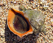
is the first benthos species which spread from the Black Sea in the early 20th century and settled in the Sea of Azov. Its current density is 7 kg/m2. From 1956, Rapana venosa
Veined rapa whelk
Rapana venosa, common name the veined rapa whelk or Asian rapa whelk, is a species of large predatory sea snail, a marine gastropod mollusk or whelk, in the family Muricidae, the rock shells....
is observed in the Sea of Azov, but it could not adjust to low salinity and therefore is limited to the neighborhood of the Kerch Strait. Several Sea of Azov mollusks, such as shipworm
Shipworm
Shipworms are not worms at all, but rather a group of unusual saltwater clams with very small shells, notorious for boring into wooden structures that are immersed in sea water, such as piers, docks and wooden ships...
(Teredo navalis), soft-shell clam
Soft-shell clam
Soft-shell clams, scientific name Mya arenaria, popularly called "steamers", "softshells", "longnecks", "piss clams", "Ipswich clams", or "Essex clams" are a species of edible saltwater clam, a marine bivalve mollusk in the family Myidae....
(Mya arernaria), Mediterranean mussel
Mediterranean mussel
The Mediterranean mussel, Mytilus galloprovincialis, also known as the bay mussel, blue mussel or Mittelmeer-Miesmuschel is a species of bivalve. It is a marine mollusc in the family Mytilidae.-Distribution:...
(Mytilus galloprovincialis) and Anadara inaequivalvis, originate from the Black Sea. Another example of invading species is the Dutch crab Rhithropanopeus harrisii which is observed both in saline and freshwater parts.
Three types of dolphins, short-beaked common dolphin
Short-beaked Common Dolphin
The short-beaked common dolphin is a species of common dolphin. It has a larger range than the long-beaked common dolphin , occurring throughout warm-temperate and tropical oceans, with the possible exception of the Indian Ocean...
, common bottlenose dolphin
Common Bottlenose Dolphin
Tursiops truncatus, commonly known as the Common Bottlenose Dolphin, is the most well-known species from the family Delphinidae.Common bottlenose dolphins are the most familiar dolphins due to the wide exposure they receive in captivity in marine parks, dolphinarias, in movies, and television...
and harbour porpoise
Harbour Porpoise
The harbour porpoise is one of six species of porpoise. It is one of the smallest marine mammals. As its name implies, it stays close to coastal areas or river estuaries, and as such, is the most familiar porpoise to whale watchers. This porpoise often ventures up rivers, and has been seen...
, regularly visited the Sea of Azov from the Black Sea. One type of harbour porpoise, Phocoena phocoena relicta, used to stay in the Sea of Azov and therefore was called "Azov dolphin" in Soviet Union. Nowadays, dolphins are rarely observed in the Sea of Azov. This is attributed to shallowing of the sea, increasing navigation activities, pollution and reduction in the fish population.
Economy and ecology
For centuries, the Sea of Azov has been an important waterway for transportation of goods and passengers. The first modern ironworks in Imperial Russia were located upstream on the KalmiusKalmius
The Kalmius is one of two rivers flowing through the Ukrainian city of Mariupol. The other river called the Kalchik flows into the Kalmius. The Kalmius flows into the Sea of Azov near the Azovstal steel manufacturing combine....
River at Donetsk
Donetsk
Donetsk , is a large city in eastern Ukraine on the Kalmius river. Administratively, it is a center of Donetsk Oblast, while historically, it is the unofficial capital and largest city of the economic and cultural Donets Basin region...
(formerly known as Юзовка Yuz(Hughes)ovka). It was also important for the transportation of iron ores from the mines of the Kerch peninsula to the processing plant of Azovstal in Mariupol
Mariupol
Mariupol , formerly known as Zhdanov , is a port city in southeastern Ukraine. It is located on the coast of the Azov Sea, at the mouth of the Kalmius River. Mariupol is the largest city in Priazovye - a geographical region around Azov Sea, divided by Russia and Ukraine - and is also a popular sea...
(formerly Zhdanov), Ukraine; this activity stopped after the closure of the mines in the 1990s. Navigation increased after construction in 1952 of the Volga–Don Canal which connected the Sea of Azov with the Volga River
Volga River
The Volga is the largest river in Europe in terms of length, discharge, and watershed. It flows through central Russia, and is widely viewed as the national river of Russia. Out of the twenty largest cities of Russia, eleven, including the capital Moscow, are situated in the Volga's drainage...
– the most important riverine transport route in the central Russia – and thus connecting major cities such as Moscow, Volgograd
Volgograd
Volgograd , formerly called Tsaritsyn and Stalingrad is an important industrial city and the administrative center of Volgograd Oblast, Russia. It is long, north to south, situated on the western bank of the Volga River...
and Astrakhan
Astrakhan
Astrakhan is a major city in southern European Russia and the administrative center of Astrakhan Oblast. The city lies on the left bank of the Volga River, close to where it discharges into the Caspian Sea at an altitude of below the sea level. Population:...
. Currently, the major ports are in Taganrog
Taganrog
Taganrog is a seaport city in Rostov Oblast, Russia, located on the north shore of Taganrog Bay , several kilometers west of the mouth of the Don River. Population: -History of Taganrog:...
, Zhdanov
Zhdanov
Zhdanov or Zhdanova is a surname and may refer to:People* Andrei Zhdanov , Stalinist politician, developer of the Zhdanov Doctrine that governed Soviet cultural activities for a number of years...
, Yeysk
Yeysk
-External links:* *...
and Berdyansk.
Increasing navigation rates have resulted in more pollution and even in ecological disasters. On 11 November 2007, a strong storm resulted in the sinking of four ships in the Strait of Kerch
Strait of Kerch
The Kerch Strait connects the Black Sea and the Sea of Azov, separating the Kerch Peninsula in the west from the Taman Peninsula in the east. The strait is to wide and up to deep....
, in the Russian Port of Kavkaz
Port Kavkaz
Port Kavkaz is a small harbour on the Kerch Strait in Krasnodar Krai, Russia. The port may handle the vessels being up to 130 m in length, up to 14'5 m in breadth and with draft up to 5 m...
. The ships were the Russian bulk carrier
Bulk carrier
A bulk carrier, bulk freighter, or bulker is a merchant ship specially designed to transport unpackaged bulk cargo, such as grains, coal, ore, and cement in its cargo holds. Since the first specialized bulk carrier was built in 1852, economic forces have fueled the development of these ships,...
s Volnogorsk, Nakhichevan, Kovel and the Georgian Haji Izmail with a Turkish crew. Six other ships were driven from their anchors and stranded and two tankers damaged (Volgoneft-139 and Volgoneft-123). As a result, about 1300 tons of fuel oil and about 6800 tons of sulfur entered the sea.
Another traditional activity in the sea is fishing. The Sea of Azov used to be the most productive fishing area in the Soviet Union: typical annual fish catches of 300,000 tonnes converted to 80 kg per hectare of surface. (The corresponding numbers are 2 kg in the Black Sea and 0.5 kg in the Mediterranean Sea.) The catch decreased in the 21st century, with more emphasis now on fish farming
Fish farming
Fish farming is the principal form of aquaculture, while other methods may fall under mariculture. Fish farming involves raising fish commercially in tanks or enclosures, usually for food. A facility that releases young fish into the wild for recreational fishing or to supplement a species'...
, especially of sturgeon
Sturgeon
Sturgeon is the common name used for some 26 species of fish in the family Acipenseridae, including the genera Acipenser, Huso, Scaphirhynchus and Pseudoscaphirhynchus. The term includes over 20 species commonly referred to as sturgeon and several closely related species that have distinct common...
. Traditionally much of the coastline has been a zone of health resorts.
The irrigation system of Taman Peninsula, supplied by the extended delta of Kuban River is favorable for agriculture and the region is famous for its vines. The area of Sivash lagoons and Arabat Spit had traditional salt producing industry. The Arabat Spit alone produced about 24,000 tonnes/year in 19th century.
History and etymology
The Black Sea deluge theoryBlack Sea deluge theory
The Black Sea deluge is a hypothesized catastrophic rise in the level of the Black Sea circa 5600 BC due to waters from the Mediterranean Sea breaching a sill in the Bosporus Strait. The hypothesis made headlines when The New York Times published it in December 1996, shortly before it was published...
dates the genesis of the Sea of Azov to 5600 BC, and there are traces of Neolithic
Neolithic
The Neolithic Age, Era, or Period, or New Stone Age, was a period in the development of human technology, beginning about 9500 BC in some parts of the Middle East, and later in other parts of the world. It is traditionally considered as the last part of the Stone Age...
settlement in the area now covered by it. In antiquity, it was known as Lake Mæotis, the Maeotian Lake or the Maeotian Sea (Greek
Greek language
Greek is an independent branch of the Indo-European family of languages. Native to the southern Balkans, it has the longest documented history of any Indo-European language, spanning 34 centuries of written records. Its writing system has been the Greek alphabet for the majority of its history;...
and Latin
Latin
Latin is an Italic language originally spoken in Latium and Ancient Rome. It, along with most European languages, is a descendant of the ancient Proto-Indo-European language. Although it is considered a dead language, a number of scholars and members of the Christian clergy speak it fluently, and...
Palus Maeotis), after the tribe of Maeotae
Maeotae
Maeotae or Mæotæ or Maeotici were an ancient people dwelling along the Palus Maeotis in antiquity. It is not clear whether they spoke an Iranian language or were related to the modern-day Adyghe. The best attested tribe among them was the Sindi.The earliest reference may be the logographer...
which inhabited the Maeotian marshes
Maeotian marshes
In the geography of Antiquity the Maeotian marshes lay where the Don River emptied into the Maeotian Lake near Tanais. The marshes served as a check to the westward migration of nomad peoples from the steppe of Central Asia.The area was named after the Maeotae who lived around the Maeotian Lake....
to the east from the sea. In the antique epoch, locals called the sea Temerinds. In medieval times, Russians named it Surozh Sea, after the Crimean city of Surozh (now Sudak
Sudak
Sudak or Sudaq is a small historic town located in Crimea, Ukraine situated to the west of Feodosiya and to the east of Simferopol, the capital of Crimea...
).
The current name is popularly said to come from a Polovtsian
Cumans
The Cumans were Turkic nomadic people comprising the western branch of the Cuman-Kipchak confederation. After Mongol invasion , they decided to seek asylum in Hungary, and subsequently to Bulgaria...
prince named Azum or Asuf, who was killed defending a town in this region in 1067. Alternatively, it may originate from Turkish "asak" which means "low" and may refer to the location of the sea. The sea is called "The Sea of Azof" in the 1898 Henry James
Henry James
Henry James, OM was an American-born writer, regarded as one of the key figures of 19th-century literary realism. He was the son of Henry James, Sr., a clergyman, and the brother of philosopher and psychologist William James and diarist Alice James....
' novel The Turn of the Screw
The Turn of the Screw
The Turn of the Screw is a novella written by Henry James. Originally published in 1898, it is ostensibly a ghost story.Due to its ambiguous content, it became a favourite text of academics who subscribe to New Criticism. The novella has had differing interpretations, often mutually exclusive...
.
Deluge theory
In 1997, William Ryan and Walter Pitman from Columbia UniversityColumbia University
Columbia University in the City of New York is a private, Ivy League university in Manhattan, New York City. Columbia is the oldest institution of higher learning in the state of New York, the fifth oldest in the United States, and one of the country's nine Colonial Colleges founded before the...
published a theory that a massive flood through the Bosporus
Bosporus
The Bosphorus or Bosporus , also known as the Istanbul Strait , is a strait that forms part of the boundary between Europe and Asia. It is one of the Turkish Straits, along with the Dardanelles...
occurred in ancient times. They claim that the Black and Caspian Sea
Caspian Sea
The Caspian Sea is the largest enclosed body of water on Earth by area, variously classed as the world's largest lake or a full-fledged sea. The sea has a surface area of and a volume of...
s were vast freshwater lakes, but then about 5600 BC, the Mediterranean
Mediterranean Sea
The Mediterranean Sea is a sea connected to the Atlantic Ocean surrounded by the Mediterranean region and almost completely enclosed by land: on the north by Anatolia and Europe, on the south by North Africa, and on the east by the Levant...
spilled over a rocky sill at the Bosporus
Bosporus
The Bosphorus or Bosporus , also known as the Istanbul Strait , is a strait that forms part of the boundary between Europe and Asia. It is one of the Turkish Straits, along with the Dardanelles...
, creating the current communication between the Black and Mediterranean Seas. Subsequent work has been done both to support and to discredit this theory, and archaeologists still debate it. This has led some to associate this catastrophe with prehistoric flood myths.
Azov campaigns of 1695–96 and 1736–37
The Sea of Azov had long been a matter of military conflicts between Russia, pursuing naval expansion to the south, and the major power in the region, Turkey. During the Russo-Turkish War (1686–1700), there were two campaigns in 1695–96 to capture the then Turkish fortress of Azov defended by a garrison of 7,000. The campaigns were headed by Peter I
Peter I of Russia
Peter the Great, Peter I or Pyotr Alexeyevich Romanov Dates indicated by the letters "O.S." are Old Style. All other dates in this article are New Style. ruled the Tsardom of Russia and later the Russian Empire from until his death, jointly ruling before 1696 with his half-brother, Ivan V...
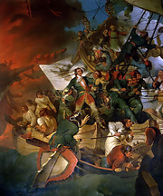
and aimed to gain Russian access to the Azov and Black seas. First campaign began in the spring of 1695. The Russian army consisted of 31 thousand people and 170 cannons and included selected trained regimens and Cossacks. It reached Azov on June 27–28 and besieged it by land by 5 July. After two unsuccessful assaults on 5 August and 25 September, the siege was lifted.
The second campaign involved both ground forces and the Azov fleet, which was built in Moscow Oblast, Voronezh, Bryansk and other regions between winter of 1695 and spring of 1696. In April 1696, the army of 75,000 headed by Aleksei Shein
Aleksei Shein
Aleksei Semyonovich Shein , Russian commander and statesman, the first Russian Generalissimus, boyar, great-grandson of Mikhail Shein....
moved to Azov on the ground and by ships via Don River to Taganrog. In early May, they were joined by another fleet led by Peter I. On 27 May, the Russian fleet blocked Azov by sea. On 14 June, Turkish fleet tried to break the blockade, but after losing two ships retreated to the sea. After intensive bombardment of the fortress from the ground and sea, on 17 July the Russian army broke the defense lines and occupied parts of the wall. After heavy fighting, the garrison surrendered on 17 July. After the war, the Russian fleet base was moved to Taganrog and Azov, and 215 ships were built there between 1696 and 1711. In 1711, as a result of the Russo-Turkish War (1710–1711) and the Treaty of the Pruth
Treaty of the Pruth
The Treaty of the Pruth was signed on the banks of the river Pruth between the Ottoman Empire and the Tsardom of Russia on 21 July 1711, ending the Russo-Turkish War of 1710–1711...
, Azov was returned to Turkey and the Russian Azov fleet was destroyed. The city was captured back by Russians in 1737 during the Russo-Austrian-Turkish War (1735–1739). However, as a result of the consequent Treaty of Niš, they were not allowed to keep the fortress and military fleet.
Crimean War 1853–56
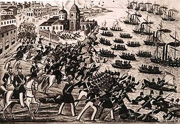
Another major military campaign on the Sea of Azov took place during the Crimean War of 1853–56. A naval and ground campaign pitting the Allied navies of Britain
United Kingdom of Great Britain and Ireland
The United Kingdom of Great Britain and Ireland was the formal name of the United Kingdom during the period when what is now the Republic of Ireland formed a part of it....
and France against Russia took place between May and November 1855. The British and French forces besieged Taganrog, aiming to disrupt Russian supplies to Crimea. Capturing Taganrog would also result in an attack on Rostov, which was a strategic city for Russian support of their Caucasian operations. On 12 May 1855, the allied forces easily captured Kerch and gained access to Azov sea, and on 22 May they attacked Taganrog. The attack failed and was followed by a siege. Despite the vast superiority of the allied forces (about 16,000 soldiers against fewer than 2,000), the city withstood all attempts to capture it, which ended around August 1855 with the retreat of the allied army. Individual coastal attacks continued but without success and were ceased in October 1855.