
Bosporus
Encyclopedia
Strait
A strait or straits is a narrow, typically navigable channel of water that connects two larger, navigable bodies of water. It most commonly refers to a channel of water that lies between two land masses, but it may also refer to a navigable channel through a body of water that is otherwise not...
that forms part of the boundary between Europe
Europe
Europe is, by convention, one of the world's seven continents. Comprising the westernmost peninsula of Eurasia, Europe is generally 'divided' from Asia to its east by the watershed divides of the Ural and Caucasus Mountains, the Ural River, the Caspian and Black Seas, and the waterways connecting...
and Asia
Asia
Asia is the world's largest and most populous continent, located primarily in the eastern and northern hemispheres. It covers 8.7% of the Earth's total surface area and with approximately 3.879 billion people, it hosts 60% of the world's current human population...
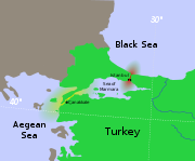
. It is one of the Turkish Straits
Turkish Straits
The term Turkish Straits refers to the two narrow straits in northwestern Turkey, the Bosphorus and the Dardanelles, that connect the Sea of Marmara with the Black Sea on one side and the Aegean arm of the Mediterranean Sea on the other. They are conventionally considered the boundary between the...
, along with the Dardanelles
Dardanelles
The Dardanelles , formerly known as the Hellespont, is a narrow strait in northwestern Turkey connecting the Aegean Sea to the Sea of Marmara. It is one of the Turkish Straits, along with its counterpart the Bosphorus. It is located at approximately...
. The world's narrowest strait used for international navigation, it connects the Black Sea
Black Sea
The Black Sea is bounded by Europe, Anatolia and the Caucasus and is ultimately connected to the Atlantic Ocean via the Mediterranean and the Aegean seas and various straits. The Bosphorus strait connects it to the Sea of Marmara, and the strait of the Dardanelles connects that sea to the Aegean...
with the Sea of Marmara
Sea of Marmara
The Sea of Marmara , also known as the Sea of Marmora or the Marmara Sea, and in the context of classical antiquity as the Propontis , is the inland sea that connects the Black Sea to the Aegean Sea, thus separating Turkey's Asian and European parts. The Bosphorus strait connects it to the Black...
(which is connected by the Dardanelles to the Aegean Sea
Aegean Sea
The Aegean Sea[p] is an elongated embayment of the Mediterranean Sea located between the southern Balkan and Anatolian peninsulas, i.e., between the mainlands of Greece and Turkey. In the north, it is connected to the Marmara Sea and Black Sea by the Dardanelles and Bosporus...
, and thereby to the Mediterranean Sea
Mediterranean Sea
The Mediterranean Sea is a sea connected to the Atlantic Ocean surrounded by the Mediterranean region and almost completely enclosed by land: on the north by Anatolia and Europe, on the south by North Africa, and on the east by the Levant...
).
Bosphorus' limits are defined as the connecting line between the lighthouses Rumeli Feneri
Rumeli Feneri
Rumeli Feneri, aka Türkeli Feneri, a historical lighthouse still in use, is located on the European side of Bosphorus' Black Sea entrance in Istanbul, Turkey. Rumeli is the former name for the Turkish lands in Europe. It is across from the Anadolu Feneri lighthouse, which is on the Asian side of...
and Anadolu Feneri
Anadolu Feneri
Anadolu Feneri is a historical lighthouse still in use, which is located on the Asian side of Bosphorus' Black Sea entrance in Istanbul, Turkey. Anadolu is the Turkish name for Anatolia. It is across from the lighthouse Rumeli Feneri, which is on the European side of the strait at a distance of...
in the north and between the Ahırkapı Feneri
Ahırkapı Feneri
The Ahırkap Feneri, a historical lighthouse still in use, is located at the southern Seraglio Point on the Rumelian coast of Bosporus' south entrance, in Ahırkapı neighborhood of Istanbul's Fatih district, Turkey. It is across from the Kadıköy İnciburnu Feneri, which is on the Anatolian coast of...
and the Kadıköy İnciburnu Feneri
Kadıköy İnciburnu Feneri
The Kadıköy İnciburnu Feneri is a lighthouse located at the head of Kadıköy Harbor's İnciburnu Breakwater on the Anatolian coast of Bosporus' south entrance, in Kadıköy district of Istanbul, Turkey. It is across from the Ahırkapı Feneri, which is on the Rumelian coast of the strait at a distance of...
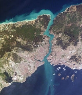
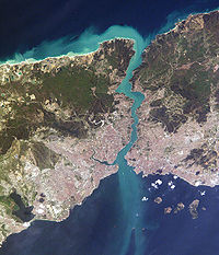
in the south. The strait is between the limits 31 km (16.7 nmi) long, with a width of 3329 m (1.8 nmi) at the northern entrance and 2826 m (1.5 nmi) at the southern entrance. Its maximum width is 3420 m (1.8 nmi) between Umuryeri and Büyükdere Limanı, and minimum width 700 m (0.377969762419006 nmi) between Kandilli Point and Aşiyan. A 45 degree course alteration is required for the ships at this point. The current can reach 7-8 knots at this point. It is a highly dangerous point for ships navigation. At yenikoy, the necessary course alteration is 80 degrees. All the dangers and obstacles characteristic of narrow waterways are present and acute in this critical sea lane. At the above mentioned turns (Kandilli and Yenikoy) where significant course alterations have to be made, the rear and forward sights are totally blocked prior to and during the course alteration. The ships approaching from the opposite direction cannot be seen round these bends. There is also very heavy ferry traffic in the Strait of Istanbul, which crosses between European and Asiatic sides of the city.
The depth of Bosphorus varies from 36 to 124 m (118.1 to 406.8 ft) in midstream with an average of 65 m (213.3 ft). The deepest location is between Kandilli and Bebek with 110 m (360.9 ft). The most shallow locations are off Kadıköy İnciburnu on the northward route with 18 m (59.1 ft) and off Aşiyan Point on the southward route with 13 m (42.7 ft).
The shores of the strait are heavily populated as the city of Istanbul
Istanbul
Istanbul , historically known as Byzantium and Constantinople , is the largest city of Turkey. Istanbul metropolitan province had 13.26 million people living in it as of December, 2010, which is 18% of Turkey's population and the 3rd largest metropolitan area in Europe after London and...
(with a metropolitan area in excess of 11 million inhabitants) straddles it.
The name comes from Greek
Greek language
Greek is an independent branch of the Indo-European family of languages. Native to the southern Balkans, it has the longest documented history of any Indo-European language, spanning 34 centuries of written records. Its writing system has been the Greek alphabet for the majority of its history;...
Bosporos (Βόσπορος), which the ancient Greeks analysed as bous 'ox' + poros 'means of passing a river, ford, ferry', thus meaning 'ox
Ox
An ox , also known as a bullock in Australia, New Zealand and India, is a bovine trained as a draft animal. Oxen are commonly castrated adult male cattle; castration makes the animals more tractable...
-ford
Ford (crossing)
A ford is a shallow place with good footing where a river or stream may be crossed by wading or in a vehicle. A ford is mostly a natural phenomenon, in contrast to a low water crossing, which is an artificial bridge that allows crossing a river or stream when water is low.The names of many towns...
'. Although it has been known for a while that the Black Sea and the Sea of Marmara flow into each other in an example of a density flow, findings of a study by the University of Leeds in August 2010 reveal that there is in fact an underwater river flowing through the Mediterranean and under the Bosphorus (caused by the difference in density of the two seas), which would be the sixth largest river on Earth if it were to be on land.
Formation
Black Sea
The Black Sea is bounded by Europe, Anatolia and the Caucasus and is ultimately connected to the Atlantic Ocean via the Mediterranean and the Aegean seas and various straits. The Bosphorus strait connects it to the Sea of Marmara, and the strait of the Dardanelles connects that sea to the Aegean...
became disconnected from the Aegean Sea
Aegean Sea
The Aegean Sea[p] is an elongated embayment of the Mediterranean Sea located between the southern Balkan and Anatolian peninsulas, i.e., between the mainlands of Greece and Turkey. In the north, it is connected to the Marmara Sea and Black Sea by the Dardanelles and Bosporus...
. The Black Sea deluge theory
Black Sea deluge theory
The Black Sea deluge is a hypothesized catastrophic rise in the level of the Black Sea circa 5600 BC due to waters from the Mediterranean Sea breaching a sill in the Bosporus Strait. The hypothesis made headlines when The New York Times published it in December 1996, shortly before it was published...
(published in 1997 by William Ryan and Walter Pitman
Walter C. Pitman, III
Walter Clarkson Pitman, III is a geophysicist and a professor emeritus at Columbia University. His measurements of magnetic anomalies on the ocean floor supported the Morley–Vine–Matthews hypothesis explaining seafloor spreading. With William Ryan, he developed the Black Sea deluge theory...
from Columbia University
Columbia University
Columbia University in the City of New York is a private, Ivy League university in Manhattan, New York City. Columbia is the oldest institution of higher learning in the state of New York, the fifth oldest in the United States, and one of the country's nine Colonial Colleges founded before the...
) contends that the Bosphorus was formed about 5600 BC when the rising waters of the Mediterranean/Sea of Marmara
Sea of Marmara
The Sea of Marmara , also known as the Sea of Marmora or the Marmara Sea, and in the context of classical antiquity as the Propontis , is the inland sea that connects the Black Sea to the Aegean Sea, thus separating Turkey's Asian and European parts. The Bosphorus strait connects it to the Black...
breached through to the Black Sea, which at the time (according to the theory) was a low-lying body of fresh water.
It is also said in myth that floating rocks known as the Symplegades
Symplegades
The Symplegades or Clashing Rocks, also known as the Cyanean Rocks, were, according to Greek mythology, a pair of rocks at the Bosphorus that clashed together randomly. They were defeated by Jason and the Argonauts, who would have been lost and killed by the rocks except for Phineas' advice. Jason...
or Clashing Rocks once crushed any ship that attempted passage of the Bosporus until the hero Jason
Jason
Jason was a late ancient Greek mythological hero from the late 10th Century BC, famous as the leader of the Argonauts and their quest for the Golden Fleece. He was the son of Aeson, the rightful king of Iolcus...
obtained passage, whereupon the rocks became fixed, and Greek access to the Black Sea was opened.
Biblical reference
St. JeromeJerome
Saint Jerome was a Roman Christian priest, confessor, theologian and historian, and who became a Doctor of the Church. He was the son of Eusebius, of the city of Stridon, which was on the border of Dalmatia and Pannonia...
's Vulgate
Vulgate
The Vulgate is a late 4th-century Latin translation of the Bible. It was largely the work of St. Jerome, who was commissioned by Pope Damasus I in 382 to make a revision of the old Latin translations...
translates the Hebrew besepharad in Obadiah, 1-20 as "Bosforus", but other translations give it as "Sepharad
Sepharad
Sepharad, or Sefarad, or Sfard, is a biblical place name of uncertain location. It is mentioned only once in the Bible, in the Book of Obadiah . There are, however, Persian inscriptions that refer to two places called "Saparda": one area in Media and another in Asia Minor...
" (probably Sardis
Sardis
Sardis or Sardes was an ancient city at the location of modern Sart in Turkey's Manisa Province...
, but later identified with Spain).
Ancient Greece, Persia, Rome, the Byzantines and the Ottoman Empire
Athens
Athens , is the capital and largest city of Greece. Athens dominates the Attica region and is one of the world's oldest cities, as its recorded history spans around 3,400 years. Classical Athens was a powerful city-state...
in the 5th century BC, which was dependent on grain imports from Scythia
Scythia
In antiquity, Scythian or Scyths were terms used by the Greeks to refer to certain Iranian groups of horse-riding nomadic pastoralists who dwelt on the Pontic-Caspian steppe...
, maintained critical alliances with cities which controlled the straits, such as the Megarian
Megara
Megara is an ancient city in Attica, Greece. It lies in the northern section of the Isthmus of Corinth opposite the island of Salamis, which belonged to Megara in archaic times, before being taken by Athens. Megara was one of the four districts of Attica, embodied in the four mythic sons of King...
colony Byzantium
Byzantium
Byzantium was an ancient Greek city, founded by Greek colonists from Megara in 667 BC and named after their king Byzas . The name Byzantium is a Latinization of the original name Byzantion...
.
Persian King Darius I the Great, in an attempt to subdue the Scythia
Scythia
In antiquity, Scythian or Scyths were terms used by the Greeks to refer to certain Iranian groups of horse-riding nomadic pastoralists who dwelt on the Pontic-Caspian steppe...
n horseman north of Black sea, crossed over at the Bosphorus, then marching up to the Danube
Danube
The Danube is a river in the Central Europe and the Europe's second longest river after the Volga. It is classified as an international waterway....
. His army crossed the Bosphorus over an enormous bridge made by connecting Achaemenid boats. This bridge essentially, connected the farthest most geographic tip of Asia, to Europe, encompasing at least some 1000 meters of open water if not more. Years later, a similar boat bridge would be constructed by Xerxes I, in his invasion of Greece.
The strategic significance of the strait was one of the factors in the decision of the Roman Emperor Constantine
Constantine I
Constantine the Great , also known as Constantine I or Saint Constantine, was Roman Emperor from 306 to 337. Well known for being the first Roman emperor to convert to Christianity, Constantine and co-Emperor Licinius issued the Edict of Milan in 313, which proclaimed religious tolerance of all...
the Great to found there in AD 330 his new capital, Constantinople
Constantinople
Constantinople was the capital of the Roman, Eastern Roman, Byzantine, Latin, and Ottoman Empires. Throughout most of the Middle Ages, Constantinople was Europe's largest and wealthiest city.-Names:...
, which came to be known as the capital of the Eastern Roman Empire. On 29 May 1453 it was conquered
Fall of Constantinople
The Fall of Constantinople was the capture of the capital of the Byzantine Empire, which occurred after a siege by the Ottoman Empire, under the command of Ottoman Sultan Mehmed II, against the defending army commanded by Byzantine Emperor Constantine XI...
by the emerging Ottoman Empire
Ottoman Empire
The Ottoman EmpireIt was usually referred to as the "Ottoman Empire", the "Turkish Empire", the "Ottoman Caliphate" or more commonly "Turkey" by its contemporaries...
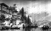
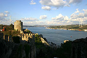
. In fact, as the Ottoman Turks closed in on Istanbul, they constructed a fortification on each side of the strait, Anadoluhisarı
Anadoluhisari
Anadoluhisarı is a fortress located in Istanbul, Turkey on the Anatolian side of the Bosporus, which also gives its name to the quarter around it...
(1393) and Rumelihisarı
Rumelihisari
Rumelihisarı is a fortress located in the Sarıyer district of Istanbul, Turkey, on a hill at the European side of the Bosporus. It gives the name of the quarter around it. It was built by the Ottoman Sultan Mehmed II between 1451 and 1452, before he conquered Constantinople...
(1451).
Strategic importance
The strategic importance of the Bosphorus remains high, and control over it has been an objective of a number of hostilities in modern history, notably the Russo–Turkish War, 1877–1878, as well as of the attack of the Allied PowersAllies of World War I
The Entente Powers were the countries at war with the Central Powers during World War I. The members of the Triple Entente were the United Kingdom, France, and the Russian Empire; Italy entered the war on their side in 1915...
on the Dardanelles
Dardanelles
The Dardanelles , formerly known as the Hellespont, is a narrow strait in northwestern Turkey connecting the Aegean Sea to the Sea of Marmara. It is one of the Turkish Straits, along with its counterpart the Bosphorus. It is located at approximately...
during the 1915 Battle of Gallipoli
Battle of Gallipoli
The Gallipoli Campaign, also known as the Dardanelles Campaign or the Battle of Gallipoli, took place at the peninsula of Gallipoli in the Ottoman Empire between 25 April 1915 and 9 January 1916, during the First World War...
in the course of World War I
World War I
World War I , which was predominantly called the World War or the Great War from its occurrence until 1939, and the First World War or World War I thereafter, was a major war centred in Europe that began on 28 July 1914 and lasted until 11 November 1918...
.
At its peak in the 16th through the 18th centuries, the Ottoman Empire had wrested control of the entire Black Sea
Black Sea
The Black Sea is bounded by Europe, Anatolia and the Caucasus and is ultimately connected to the Atlantic Ocean via the Mediterranean and the Aegean seas and various straits. The Bosphorus strait connects it to the Sea of Marmara, and the strait of the Dardanelles connects that sea to the Aegean...
area, which was for the time an "Ottoman lake", on which Russian warships were prohibited.
Subsequently, several international treaties have governed vessels using the waters. Under the Treaty of Hünkar Iskelesi of 1833, the Bosporus and Dardanelles straits were to be closed on Russian demand to naval vessels of other powers. Following World War I, the 1920 Treaty of Sèvres
Treaty of Sèvres
The Treaty of Sèvres was the peace treaty between the Ottoman Empire and Allies at the end of World War I. The Treaty of Versailles was signed with Germany before this treaty to annul the German concessions including the economic rights and enterprises. Also, France, Great Britain and Italy...
demilitarized the strait and made it an international territory under the control of the League of Nations
League of Nations
The League of Nations was an intergovernmental organization founded as a result of the Paris Peace Conference that ended the First World War. It was the first permanent international organization whose principal mission was to maintain world peace...
. This was amended under the 1923 Treaty of Lausanne
Treaty of Lausanne
The Treaty of Lausanne was a peace treaty signed in Lausanne, Switzerland on 24 July 1923, that settled the Anatolian and East Thracian parts of the partitioning of the Ottoman Empire. The treaty of Lausanne was ratified by the Greek government on 11 February 1924, by the Turkish government on 31...
, which restored the straits to Turkish territorybut allowed all foreign warships and commercial shipping to traverse the straits freely. Turkey eventually rejected the terms of that treaty, and subsequently Turkey remilitarized the straits area. The reversion to this old regime was formalized under the Montreux Convention Regarding the Regime of the Turkish Straits
Montreux Convention Regarding the Regime of the Turkish Straits
The Montreux Convention Regarding the Regime of the Straits was a 1936 agreement that gives Turkey control over the Bosporus Straits and the Dardanelles and regulates military activity in the region. The Convention gives Turkey full control over the Straits and guarantees the free passage of...
of July 1936. That convention, which is still in practical force , treats the straits as an international shipping lane, but Turkey retains the right to restrict the naval traffic of non-Black Sea nations (such as Greece
Greece
Greece , officially the Hellenic Republic , and historically Hellas or the Republic of Greece in English, is a country in southeastern Europe....
, a traditional enemy, or Algeria
Algeria
Algeria , officially the People's Democratic Republic of Algeria , also formally referred to as the Democratic and Popular Republic of Algeria, is a country in the Maghreb region of Northwest Africa with Algiers as its capital.In terms of land area, it is the largest country in Africa and the Arab...
).
During World War II
World War II
World War II, or the Second World War , was a global conflict lasting from 1939 to 1945, involving most of the world's nations—including all of the great powers—eventually forming two opposing military alliances: the Allies and the Axis...
, through February 1945, when Turkey was neutral for most of the length of the conflict, the Dardanelles were closed to the ships of the belligerent nations. In the conferences during World War II, Soviet leader Joseph Stalin
Joseph Stalin
Joseph Vissarionovich Stalin was the Premier of the Soviet Union from 6 May 1941 to 5 March 1953. He was among the Bolshevik revolutionaries who brought about the October Revolution and had held the position of first General Secretary of the Communist Party of the Soviet Union's Central Committee...
openly requested the concession of Soviet military bases on the Straits, even though Turkey was not involved in the war. This incident, coupled with Stalin's demands for the restitution of the Turkish provinces of Kars
Kars Province
Kars Province is a province of Turkey, located in the northeastern part of the country. It shares part of its border with the Republic of Armenia.The provinces of Ardahan and Iğdır were until the 1990s part of Kars Province.-History:...
, Artvin
Artvin
-History:See Artvin Province for the history of the region.-Places of interest:* Artvin or Livana castle, built in 937There are a number of Ottoman Empire houses and public buildings including:* Salih Bey mosque, built in 1792...
and Ardahan
Ardahan
Ardahan is a city in northeastern Turkey, near the Georgian border.-Ancient and medieval:In Ancient times the region was called Gogarene, which is assumed to derive from the name of Gugars, who were a Proto-Kartvelian tribe...
to the Soviet Union
Soviet Union
The Soviet Union , officially the Union of Soviet Socialist Republics , was a constitutionally socialist state that existed in Eurasia between 1922 and 1991....
(which were lost by Turkey with the Russo–Turkish War of 1877–1878, but were regained with the Treaty of Kars
Treaty of Kars
The Treaty of Kars was a "friendship" treaty signed in Kars on October 13, 1921 and ratified in Yerevan on September 11 1922.Signatories included representatives from the Grand National Assembly of Turkey, which in 1923 would declare the Republic of Turkey, and also from Soviet Armenia, Soviet...
in 1921) was one of the main reasons why Turkey decided to give up its general principle of neutrality in foreign affairs. Turkey did declare war against Germany in February 1945, but did not engage in offensive actions.
In more recent years, the Turkish Straits have become particularly important for the oil industry. Russian oil, from ports such as Novorossyisk, is exported by tankers to western Europe and the U.S. via the Bosphorus and the Dardanelles straits.
Crossings
Bridge
A bridge is a structure built to span physical obstacles such as a body of water, valley, or road, for the purpose of providing passage over the obstacle...
s cross the Bosphorus. The first, the Bosphorus Bridge
Bosphorus Bridge
The Bosphorus Bridge, also called the First Bosphorus Bridge is one of the two bridges in Istanbul, Turkey, spanning the Bosphorus strait and thus connecting Europe and Asia The bridge is located between Ortaköy and Beylerbeyi The Bosphorus Bridge, also called the First Bosphorus Bridge is...
, is 1074 m (3,524 ft) long and was completed in 1973. The second, Fatih Sultan Mehmet (Bosphorus II) Bridge
Fatih Sultan Mehmet Bridge
The Fatih Sultan Mehmet Bridge, also known as the Second Bosphorus Bridge , is a bridge in Istanbul, Turkey spanning the Bosphorus strait...
, is 1090 m (3,576 ft) long, and was completed in 1988 about 5 km (3 mi) north of the first bridge. It forms part of the Trans-European Motorway. Plans for a third bridge
Third Bosphorus Bridge
The Third Bosphorus Bridge is a planned suspension bridge located at the northern end of the Bosphorus, north of the other two bridges, in Istanbul, Turkey...
, which will allow transit traffic to by-pass the city traffic, have been approved by the Ministry of Transportation. The bridge will be built near the northern end of the Bosphorus, between the villages of Garipçe on the European side and Poyrazköy on the Asian side. It will be part of the "Northern Marmara Motorway", which will be further integrated with the existing Black Sea Coastal Highway.
Another crossing, Marmaray, is a 13.7 km (8.5 mi) long undersea railway
Rail transport
Rail transport is a means of conveyance of passengers and goods by way of wheeled vehicles running on rail tracks. In contrast to road transport, where vehicles merely run on a prepared surface, rail vehicles are also directionally guided by the tracks they run on...
tunnel
Tunnel
A tunnel is an underground passageway, completely enclosed except for openings for egress, commonly at each end.A tunnel may be for foot or vehicular road traffic, for rail traffic, or for a canal. Some tunnels are aqueducts to supply water for consumption or for hydroelectric stations or are sewers...
currently under construction and is expected to be completed in 2012. Approximately 1400 m (4,593 ft) of the tunnel will run under the strait, at a depth of about 55 m (180 ft).
- Istanbul ferry
Submarine Channel
In 2010, a team of scientists led by the University of Leeds used a robotic 'yellow submarine' to observe detailed flows within an 'undersea river' for the very first time. Submarine channels are similar to land rivers, but they are formed by density currents - underwater flow mixtures of sand, mud and water that are denser than sea water and so sink and flow along the bottom. These channels are the main transport pathway for sediments to the deep sea where they form sedimentary deposits. These deposits ultimately hold not only untapped reserves of gas and oil, they also house important secrets - from clues on past climate change to the ways in which mountains were formed.The team, led by Dr Dan Parsons and Dr Jeff Peakall from the University of Leeds, has been able to study the detailed flow within these channels. Dr Parsons quoted as: "The channel complex and the density flow provide the ideal natural laboratory for investigating and detailing the structure of the flow field through the channel. Our initial findings show that the flow in these channels is quite different to the flow in river channels on land. Specifically as flow moves around a bend it spirals in the opposite direction in the deep sea compared to the spiral to that found in river channels on land. This is important in understanding the sedimentology and layers of sediment deposited by these systems."
It is thought by some that the channels in the Black Sea were formed around 6,000 years ago when sea levels were approaching their current point. The Mediterranean swelled and breached through into the Black Sea - once an isolated freshwater lake - via the Bosphorus Strait. As the waters surged, they carried a dense, salty fluid which formed a network of sea-floor channels that are almost constantly active, even today.
Some people even believe that this was the biblical event Noah's flood, but despite their historical significance, the first spectacular images of these submarine channels were obtained in 1999 by Di Iorio et al. in the frame of a NATO SACLANT Undersea Research project using jointly the NATO RV Alliance, and the Turkish Navy Survey ship "Cubuklu". In 2002, a new survey was carried out on board the Ifremer RV "Le Suroit" for BlaSON project (Lericolais, et al., 2003 ) completed the multibeam mapping of this underwater channel fan-delta. A complete map was published in 2009 by Flood et al. using these previous results with high quality mapping obtained in 2006 (by researchers at Memorial University, Newfoundland, Canada who are project partners in this study).
The team will use the data obtained to create innovative computer simulations that can be used to model how sediment flows through these channels. The models the team will produce will have broad applications, including inputting into the design of seafloor engineering by oil and gas companies.
The project was led by Dr Jeff Peakall and Dr Daniel Parsons at the University of Leeds in collaboration with the University of Southampton, Memorial University (Newfoundland, Canada), and the Institute of Marine Sciences (Izmir, Turkey). The survey was run and coordinated from the Institute of Marine Sciences research ship, the R/V Koca Piri Reis
RV K. Piri Reis
The RV K. Piri Reis is a Turkish multi purpose research vessel owned by Dokuz Eylül University in İzmir and operated by its Institute of Marine Sciences and Technology. Built in West Germany and launched in 1978, she was named in honor of the Ottoman naval captain and renowned cartographer Piri...
.
The researchers estimate that the river - known as a submarine channel - would be the sixth largest river in the world if it were on land based on the amount of water flowing through it.
Sightseeing
A cheap way to explore the Bosporus is offered by the public ferries that traverse the Bosporus from EminönüEminönü
Eminönü is a former district of Istanbul in Turkey, now a neighbourhood of Fatih district. This is the heart of the walled city of Constantine, the focus of a history of incredible richness. Eminönü covers the point on which the Byzantine capital was built. The Galata Bridge crosses the Golden Horn...
(ferries dock at the Boğaz Iskelesi) on the historic peninsula of Istanbul to Anadolu Kavağı near the Black Sea, zigzagging between the Rumelian and Anatolian sides of the city.
It is also possible to experience the Bosphorus by taking a regular ride in one of the public ferries that travel between the European and the Asian sides. It is also possible to travel by the privately owned ferries available between Üsküdar
Üsküdar
Üsküdar is a large and densely populated municipality of Istanbul, Turkey, on the Anatolian shore of the Bosphorus. It is bordered on the north by Beykoz, on the east by Ümraniye, on the southeast by Ataşehir, on the south by Kadıköy, and on the west by the Bosphorus, with the areas of Beşiktaş,...
and Beşiktaş
Besiktas
Beşiktaş is a municipality of Istanbul, Turkey, located on the European shore of the Bosphorus. It is bordered on the north by Sarıyer and Şişli, on the west by Kağıthane and Şişli, on the south by Beyoğlu, and on the east by the Bosphorus...
or Kabataş
Kabatas
Kabataş, formerly Karay, is a town and district of Ordu Province in the Black Sea region of Turkey. According to the 2000 census, population of the district is 20,644 of which 9,211 live in the town of Kabataş...
.
There are also tourist rides available in various places along the coasts of the Bosphorus. The prices vary according to the type of the ride, and some feature loud popular music for the duration of the trip.