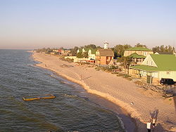
Taganrog Bay
Encyclopedia

Sea of Azov
The Sea of Azov , known in Classical Antiquity as Lake Maeotis, is a sea on the south of Eastern Europe. It is linked by the narrow Strait of Kerch to the Black Sea to the south and is bounded on the north by Ukraine mainland, on the east by Russia, and on the west by the Ukraine's Crimean...
. At its northeast end is the mouth of the Don
Don River (Russia)
The Don River is one of the major rivers of Russia. It rises in the town of Novomoskovsk 60 kilometres southeast from Tula, southeast of Moscow, and flows for a distance of about 1,950 kilometres to the Sea of Azov....
River. Length: about 140 km, width at the mouth: 31 km, median depth: about 5 m. It may freeze some winters from December to March.
Its mouth is marked by the Dolgaya Spit
Dolgaya Spit
The Dolgaya Spit is a sandy spit in the Sea of Azov. Length is 17 km, the width is about 500 m. The spit is located in Yeysk District of Krasnodar Krai, Russia...
on the south and the Belosaray Spit (Belosarayskaya Spit) on the north. It abounds in sandy spit
Spit (landform)
A spit or sandspit is a deposition landform found off coasts. At one end, spits connect to land, and extend into the sea. A spit is a type of bar or beach that develops where a re-entrant occurs, such as at cove's headlands, by the process of longshore drift...
s that partly enclose shallow bays. The bay contains Sandy Isles (Песчаные острова). Rivers Don, Kalmius
Kalmius
The Kalmius is one of two rivers flowing through the Ukrainian city of Mariupol. The other river called the Kalchik flows into the Kalmius. The Kalmius flows into the Sea of Azov near the Azovstal steel manufacturing combine....
, Mius and Yeya
Yeya River
Yeya is a river in Krasnodar Krai, Russia. It falls into the Yeya Firth of Taganrog Bay, Sea of Azov. Length: 311 km, basin area: 8,650 km2. It dries up in summer. A port town of Yeysk is located by the Yeya Firth at the neck of the Yeya Spit. The river then travels to other, smaller...
fall into the Taganrog Bay. The major ports are Taganrog
Taganrog
Taganrog is a seaport city in Rostov Oblast, Russia, located on the north shore of Taganrog Bay , several kilometers west of the mouth of the Don River. Population: -History of Taganrog:...
, Mariupol
Mariupol
Mariupol , formerly known as Zhdanov , is a port city in southeastern Ukraine. It is located on the coast of the Azov Sea, at the mouth of the Kalmius River. Mariupol is the largest city in Priazovye - a geographical region around Azov Sea, divided by Russia and Ukraine - and is also a popular sea...
(Ukraine
Ukraine
Ukraine is a country in Eastern Europe. It has an area of 603,628 km², making it the second largest contiguous country on the European continent, after Russia...
), and Yeysk
Yeysk
-External links:* *...
. Rostov-on-Don is a few miles up the Don river.

