

Public Land Survey System
Encyclopedia
The Public Land Survey System (PLSS) is a method used in the United States
to survey and identify land parcels, particularly for titles and deeds of rural, wild or undeveloped land. Its basic units of area are the township
and section. It is sometimes referred to as the rectangular survey system, although non rectangular methods such as meandering can also be used. The survey was "the first mathematically designed system and nationally conducted cadastral
survey in any modern country" and is "an object of study by public officials of foreign countries as a basis for land reform." The detailed survey methods to be applied for the PLSS are described in a series of Instructions and Manuals issued by the General Land Office
beginning in 1851, the latest edition being the "The Manual of Instructions for the Survey of the Public Lands of the United States, 20089989" available from the U.S. Government Printing Office.
 Originally proposed by Thomas Jefferson
to create a nation of "yeoman farmers”, the PLSS began shortly after the American Revolutionary War
. The Land Ordinance of 1785
was the beginning of the Public Land Survey System. The Continental Congress
was deeply in debt following the Declaration of Independence
. With little power to tax, the federal government decided to use the sale of the Western Territories to pay off American Revolutionary War
debt. It has been expanded and slightly modified by Letters of Instruction and Manuals of Instruction, issued by the General Land Office and the Bureau of Land Management and continues in use in most of the states west of Pennsylvania
, south to Florida
, Alabama
, and Mississippi
, west to the Pacific Ocean
, and north into the Arctic
in Alaska
.
(including their derivatives Maine, Vermont, Tennessee, Kentucky and West Virginia) continued the British
system of metes and bounds
. This system describes property lines based on local markers and bounds drawn by humans, often based on topography. A typical, yet simple, description under this system might read "From the point on the north bank of Muddy Creek one mile (1.6 km) above the junction of Muddy and Indian Creeks, north for 400 yards, then northwest to the large standing rock, west to the large oak tree, south to Muddy Creek, then down the center of the creek to the starting point."
Particularly in New England
, this system was supplemented by drawing town
plat
s. The metes-and-bounds system was used to describe a town of a generally rectangular shape, 4 to 6 miles (~6 to 10 km) on a side. Within this boundary, a map or plat was maintained that showed all the individual lots or properties.
There are some difficulties with this system:
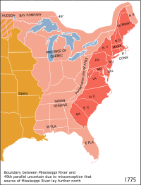
In addition this system didn't work until there were already people on the ground to maintain records. In the 1783 Treaty of Paris
recognizing the United States
, Britain also recognized American rights to the land south of the Great Lakes
and west to the Mississippi River
.
The Continental Congress
passed the Land Ordinance of 1785
and then the Northwest Ordinance
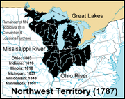
in 1787 to control the survey, sale, and settling of the new lands. The original 13 colonies donated their western lands to the new Union, for the purpose of giving land for new states. These include the lands that formed the Northwest Territory
, Kentucky
, Tennessee
, Alabama
, and Mississippi
. The state that gave up the most was Virginia
, whose original claim included most of the Northwest Territory and Kentucky, too. Some of the western land was claimed by more than one state, especially in the Northwest, where parts were claimed by Virginia, Pennsylvania, and Connecticut, all three of which had claimed lands all the way to the Pacific Ocean.
in an area called the Seven Ranges
.
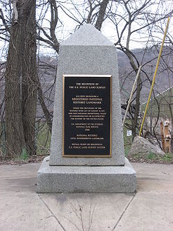
The Beginning Point of the U.S. Public Land Survey
is located at a point on the Ohio-Pennsylvania border between East Liverpool, Ohio
and the Pittsburgh metropolitan area, on private property. A National Historic Landmark
marker commemorating the site lies on the side of a state highway, exactly 1112 feet (338.9 m) to the north of the point.
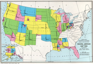
Ohio was surveyed in several major subdivisions, collectively described as the Ohio Lands
, each with its own meridian
and baseline
. The early surveying, particularly in Ohio, was performed with more speed than care, with the result that many of the oldest townships and sections vary considerably from their prescribed shape and area. Proceeding westward, accuracy became more of a consideration than rapid sale, and the system was simplified by establishing one major north-south line (principal meridian
) and one east-west (base) line that control descriptions for an entire state or more. For example, a single Willamette Meridian serves both Oregon
and Washington. County lines frequently follow the survey, so there are many rectangular counties in the Midwest and the West.
The territory under the jurisdiction of the Thirteen Colonies
at the time of independence did not adopt the PLSS, with the exception of the area that became the Northwest Territory
and some of the Southern states. This territory is now Georgia
, Connecticut
, Delaware
, Kentucky
, Maine
, Maryland
, Massachusetts
, New Hampshire
, New Jersey
, New York
, North Carolina
, Pennsylvania
, Rhode Island
, South Carolina
, Tennessee
, Vermont
, Virginia
, and West Virginia
.
The old Cherokee lands
in Georgia
use the term section as a land designation, but does not define the same area as the section used by the PLSS.
Maine
uses a variant of the system in unsettled parts of the state.
Other major exceptions to PLSS are
, which runs east-west and a principal meridian
, which runs north-south (Fig. 1). These two lines pass through, and intersect at, a location known as an initial point. Next, at a defined distance interval, commonly 24 or 30 miles (48.3 km) depending on the year and location, standard parallels are established parallel to the baseline. The meridian, baseline and standard parallels thus established form a lattice upon which all further surveying is then based. Subsequent work divides the land into survey township
s of roughly 36 square miles (~93 km2) or 6 miles (~9.7 km) on each side. This is done by the establishing of township and range lines, which run parallel to the baseline and principal meridian, respectively, at six mile (10 km) intervals. Lastly, townships are subdivided into 36 sections
of one square mile (640 acres, ~2.6 km2) and 144 quarter-sections of 0.25 square mile (160 acres, ~0.65 km2) each. (See descriptions and figures illustrating the system). The federal government typically surveys only to the quarter-section level; smaller parcels are usually surveyed later by private surveyors if necessary.
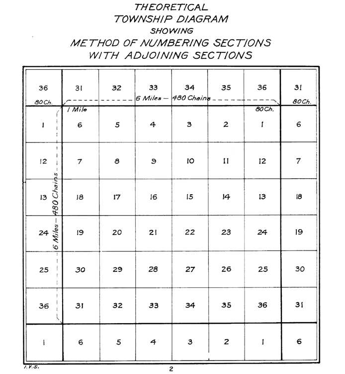 The townships and sections are indexed based on the township's position relative to the initial point and the section's location within the designated township. Township, range, and section are abbreviated as T, R, and S, respectively, and cardinal bearings from the initial point by N, S, E, and W, and each principal meridian has its abbreviation. Thus, for example, S13-T1S-R20E MDM refers to: Section 13, Township 1 South, Range 20 East, Mount Diablo Meridian, or the 13th section in the first township south of the baseline and 20th township east of the principal meridian. The sections within a township are numbered boustrophedon
ically (Fig. 2). Starting in the northeast corner, sections in the first row (sections 1-6) are numbered east to west, those in the second row (sections 7-12) are numbered west to east, the direction continuing to alternate with each row, until section 36 is reached in the southeast corner. Distances were measured using chains and links based on Edmund Gunter
’s chain for plotting ground. A chain was made up of 100 links. Each link measured 7.92 inches (20.1 cm). Each chain measured 66 feet (20.1 m) long. 80 chains equal one U.S. Survey Mile. NOTE: A U.S. Survey Mile differs from the International Mile by a few millimeters. In areas where measuring by chain was not possible, such as variable elevated terrain or terrain with water obstructions, distance was calculated using triangulation
. The importance of the PLSS is one of the many barriers to metrication
of property title in the United States.
The intersection of a township line with a range line is called a township corner, of a section line with another section, township or range line a section corner, and a point halfway between two section corners a quarter corner. At each such corner, a corner monument is established to mark the location of the corner on the ground. This monument is the legally binding mark used for setting property lines; it is the culminating work of the entire survey. As with most surveying specifications, those for the corners have changed over time. In the 19th century, the monuments were commonly a rock pile, a wooden post, or a combination of the two. Trees were also sometimes used when available. In the 20th century, steel pipes with caps, supported by mounds of rock, became required (e.g. Fig. 3). Monuments are always witnessed to by the marking of other nearby natural objects on the ground. These witnesses can be trees, rocks, or trenches dug in the ground; the exact locations of the witness objects, and the markings made on them, are recorded in the surveyor's official field notes. Witness trees are commonly referred to as bearing trees, and they are highly important, not just for their legal purposes, but also for their use by ecologists in the estimation of historic forest
vegetation
conditions. The witness objects are designed to allow subsequent surveyors and landowners to find the original corner monument location should the actual monument be destroyed. It was not uncommon for squatters or homestead
ers to destroy corner monuments if they felt the patenting of the land would threaten their residence on it. For this reason, destruction of corner monuments or their witness objects is a federal offense.
 Because the grid is flat and the earth is round, adjustments must be made periodically; not all sections can be one square mile nor can all townships be exactly 36 square miles. These adjustments are done within each township by starting the sectional surveys of the township in the southeast corner and moving progressively toward the northwest corner. The northernmost and westernmost tier of sections—11 in all—are allowed to deviate from one square mile, but the other 25 are not. This method accommodates the curvature effects, and also allows for the correction of errors made during the surveying—which were not uncommon—without overly compromising the rectangular nature of the system.
The elements of such descriptions are interpreted from right to left, so we are describing a plot of land in the township that is the third east of the Range Line (R3E) and the second south of the base line (T2S).
We are also looking at section 22 in that township (refer to the grid above).
Next that section is divided into quarters (160 acres each), and we should be in the SE quarter section.
That section is divided again in quarters (40 acres) and the description calls for the SW quarter.
Last in this description, it is quartered again (into 10 acre plots), as we want the NW quarter.
So, in language, the example plot is the NW quarter of the SW quarter of the SE quarter of section 22 of the township that is the second south of the base line and the third east of the range line.
Some descriptions will use other references such as S½ to refer to the south half of a quarter section.
As an area became settled a township and county name might replace the range and base line numbers, but they can always be traced backwards.
Some western states have only one base line. (Notice that these states have straight line borders to the north or south.) This means that all the townships in the state are either north or south. (The base line for survey of the Kansas and Nebraska territories was the 40th parallel dividing them.) They also typically have only one principal meridian. (For examples, the Kansas
range line is 97° west of Greenwich
). In the Maine variant of the system, the range line is called the "East Line of State"; all ranges are to the west of this line, and are normally written TxRx WELS, or "West from East Line of State".
Abraham Lincoln
) was the first major land grant specifically for the transcontinental railroad
. This act provided surveyed, public lands for a railroad right-of-way
to build rail systems, and millions acres to raise the capital needed to build and maintain the future railways.
Ten square miles of land on each side of the proposed rail track were granted for every one mile of completed railway. The U.S. Public Land Survey System was utilized for measurement. Every one-mile railway completed was akin to a section. If the railway ran predominantly east and west, a 10 miles (16.1 km) range of one square mile sections were allotted on each side of the 400 feet (121.9 m) right-of-way. If the railway ran predominantly north and south, a 10 miles (16.1 km) township of one square mile sections were allotted on each side of the 400 feet (121.9 m) right-of-way. The land was granted in alternating sections (one square mile). Each odd numbered section going to the railroad company. Each even numbered section kept by the government. This created a checkerboard pattern along proposed rail way. This was supposed to guarantee that railroad access would increase the value of not only the railroad granted sections, but also the government owned sections in the checkerboard. The system was devised by Senator Stephen A. Douglas
, with political support from Senator Jefferson Davis
.
.
in the United States. The U.S. Public Land Survey System has used the Gunter's chain
as a basic measurement.
"...the measurements of every plot of ground in the United States have been made in acres, feet, and inches, and are publicly recorded with the titles to the land according to the record system peculiar to this country." —Franklin Institute of Philadelphia (1876). Because of this, redefining property boundaries could create a large amount of legal issues and property owner confusion. Many local zoning laws are defined in feet/square feet. Conversion of units
for surveyors are not always simple and complex decisions are frequently required (non-universal conversion factors, soft/hard conversions, number rounding).
or section line roads, usually designed primarily for automobile travel and limited in their use for non-motorized travel. In post-World War II
suburbs, commercial development has largely occurred along and at intersections of arterials, while the rest of the former square-mile sections have generally filled with residential development, as well as schools, religious facilities, and parks. One example of this is famous Mile Road System of Detroit, Michigan
.
Occasionally, and more frequently in a metropolitan
region's inner postwar suburb
s than in outer areas, arterials are located at approximately half-mile intervals. This strictly regimented urban (or suburban) structure has coincided with the similarly strict practice of Euclidean zoning (named after the town of Euclid, Ohio
, which won a 1926 Supreme
Court case Village of Euclid, Ohio v. Ambler Realty Co.
, which established the constitutionality of zoning). In Euclidean zoning, use of a property is dictated and regulated by zoning district, the boundaries of which are often based on locations of arterials.
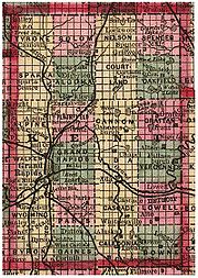
West of the Appalachians
, road systems frequently follow the PLSS grid structure (see illustrations of Nebraska vs North Carolina on left). The results can be 90-degree intersections and very long stretches of straight roads.
", which are sometimes heard in American movies, reference the quarter-quarter section.
United States
The United States of America is a federal constitutional republic comprising fifty states and a federal district...
to survey and identify land parcels, particularly for titles and deeds of rural, wild or undeveloped land. Its basic units of area are the township
Survey township
Survey township, sometimes called Congressional township, as used by the United States Public Land Survey System, refers to a square unit of land, that is nominally six miles on a side...
and section. It is sometimes referred to as the rectangular survey system, although non rectangular methods such as meandering can also be used. The survey was "the first mathematically designed system and nationally conducted cadastral
Cadastre
A cadastre , using a cadastral survey or cadastral map, is a comprehensive register of the metes-and-bounds real property of a country...
survey in any modern country" and is "an object of study by public officials of foreign countries as a basis for land reform." The detailed survey methods to be applied for the PLSS are described in a series of Instructions and Manuals issued by the General Land Office
General Land Office
The General Land Office was an independent agency of the United States government responsible for public domain lands in the United States. It was created in 1812 to take over functions previously conducted by the United States Department of the Treasury...
beginning in 1851, the latest edition being the "The Manual of Instructions for the Survey of the Public Lands of the United States, 20089989" available from the U.S. Government Printing Office.
History of the system
Thomas Jefferson
Thomas Jefferson was the principal author of the United States Declaration of Independence and the Statute of Virginia for Religious Freedom , the third President of the United States and founder of the University of Virginia...
to create a nation of "yeoman farmers”, the PLSS began shortly after the American Revolutionary War
American Revolutionary War
The American Revolutionary War , the American War of Independence, or simply the Revolutionary War, began as a war between the Kingdom of Great Britain and thirteen British colonies in North America, and ended in a global war between several European great powers.The war was the result of the...
. The Land Ordinance of 1785
Land Ordinance of 1785
The Land Ordinance of 1785 was adopted by the United States Congress on May 20, 1785. Under the Articles of Confederation, Congress did not have the power to raise revenue by direct taxation of the inhabitants of the United States...
was the beginning of the Public Land Survey System. The Continental Congress
Continental Congress
The Continental Congress was a convention of delegates called together from the Thirteen Colonies that became the governing body of the United States during the American Revolution....
was deeply in debt following the Declaration of Independence
Declaration of independence
A declaration of independence is an assertion of the independence of an aspiring state or states. Such places are usually declared from part or all of the territory of another nation or failed nation, or are breakaway territories from within the larger state...
. With little power to tax, the federal government decided to use the sale of the Western Territories to pay off American Revolutionary War
American Revolutionary War
The American Revolutionary War , the American War of Independence, or simply the Revolutionary War, began as a war between the Kingdom of Great Britain and thirteen British colonies in North America, and ended in a global war between several European great powers.The war was the result of the...
debt. It has been expanded and slightly modified by Letters of Instruction and Manuals of Instruction, issued by the General Land Office and the Bureau of Land Management and continues in use in most of the states west of Pennsylvania
Pennsylvania
The Commonwealth of Pennsylvania is a U.S. state that is located in the Northeastern and Mid-Atlantic regions of the United States. The state borders Delaware and Maryland to the south, West Virginia to the southwest, Ohio to the west, New York and Ontario, Canada, to the north, and New Jersey to...
, south to Florida
Florida
Florida is a state in the southeastern United States, located on the nation's Atlantic and Gulf coasts. It is bordered to the west by the Gulf of Mexico, to the north by Alabama and Georgia and to the east by the Atlantic Ocean. With a population of 18,801,310 as measured by the 2010 census, it...
, Alabama
Alabama
Alabama is a state located in the southeastern region of the United States. It is bordered by Tennessee to the north, Georgia to the east, Florida and the Gulf of Mexico to the south, and Mississippi to the west. Alabama ranks 30th in total land area and ranks second in the size of its inland...
, and Mississippi
Mississippi
Mississippi is a U.S. state located in the Southern United States. Jackson is the state capital and largest city. The name of the state derives from the Mississippi River, which flows along its western boundary, whose name comes from the Ojibwe word misi-ziibi...
, west to the Pacific Ocean
Pacific Ocean
The Pacific Ocean is the largest of the Earth's oceanic divisions. It extends from the Arctic in the north to the Southern Ocean in the south, bounded by Asia and Australia in the west, and the Americas in the east.At 165.2 million square kilometres in area, this largest division of the World...
, and north into the Arctic
Arctic
The Arctic is a region located at the northern-most part of the Earth. The Arctic consists of the Arctic Ocean and parts of Canada, Russia, Greenland, the United States, Norway, Sweden, Finland, and Iceland. The Arctic region consists of a vast, ice-covered ocean, surrounded by treeless permafrost...
in Alaska
Alaska
Alaska is the largest state in the United States by area. It is situated in the northwest extremity of the North American continent, with Canada to the east, the Arctic Ocean to the north, and the Pacific Ocean to the west and south, with Russia further west across the Bering Strait...
.
Origins of the system
The original coloniesThirteen Colonies
The Thirteen Colonies were English and later British colonies established on the Atlantic coast of North America between 1607 and 1733. They declared their independence in the American Revolution and formed the United States of America...
(including their derivatives Maine, Vermont, Tennessee, Kentucky and West Virginia) continued the British
Great Britain
Great Britain or Britain is an island situated to the northwest of Continental Europe. It is the ninth largest island in the world, and the largest European island, as well as the largest of the British Isles...
system of metes and bounds
Metes and bounds
Metes and bounds is a system or method of describing land, real property or real estate. The system has been used in England for many centuries, and is still used there in the definition of general boundaries...
. This system describes property lines based on local markers and bounds drawn by humans, often based on topography. A typical, yet simple, description under this system might read "From the point on the north bank of Muddy Creek one mile (1.6 km) above the junction of Muddy and Indian Creeks, north for 400 yards, then northwest to the large standing rock, west to the large oak tree, south to Muddy Creek, then down the center of the creek to the starting point."
Particularly in New England
New England
New England is a region in the northeastern corner of the United States consisting of the six states of Maine, New Hampshire, Vermont, Massachusetts, Rhode Island, and Connecticut...
, this system was supplemented by drawing town
Town
A town is a human settlement larger than a village but smaller than a city. The size a settlement must be in order to be called a "town" varies considerably in different parts of the world, so that, for example, many American "small towns" seem to British people to be no more than villages, while...
plat
Plat
A plat in the U.S. is a map, drawn to scale, showing the divisions of a piece of land. Other English-speaking countries generally call such documents a cadastral map or plan....
s. The metes-and-bounds system was used to describe a town of a generally rectangular shape, 4 to 6 miles (~6 to 10 km) on a side. Within this boundary, a map or plat was maintained that showed all the individual lots or properties.
There are some difficulties with this system:
- Irregular shapes for properties make for much more complex descriptions.
- Over time, these descriptions become problematic as trees die or streams move by erosion.
- It wasn't useful for the large, newly surveyed tracts of land being opened in the west, which were being sold sight unseen to investors.
In addition this system didn't work until there were already people on the ground to maintain records. In the 1783 Treaty of Paris
Treaty of Paris (1783)
The Treaty of Paris, signed on September 3, 1783, ended the American Revolutionary War between Great Britain on the one hand and the United States of America and its allies on the other. The other combatant nations, France, Spain and the Dutch Republic had separate agreements; for details of...
recognizing the United States
United States
The United States of America is a federal constitutional republic comprising fifty states and a federal district...
, Britain also recognized American rights to the land south of the Great Lakes
Great Lakes
The Great Lakes are a collection of freshwater lakes located in northeastern North America, on the Canada – United States border. Consisting of Lakes Superior, Michigan, Huron, Erie, and Ontario, they form the largest group of freshwater lakes on Earth by total surface, coming in second by volume...
and west to the Mississippi River
Mississippi River
The Mississippi River is the largest river system in North America. Flowing entirely in the United States, this river rises in western Minnesota and meanders slowly southwards for to the Mississippi River Delta at the Gulf of Mexico. With its many tributaries, the Mississippi's watershed drains...
.
The Continental Congress
Continental Congress
The Continental Congress was a convention of delegates called together from the Thirteen Colonies that became the governing body of the United States during the American Revolution....
passed the Land Ordinance of 1785
Land Ordinance of 1785
The Land Ordinance of 1785 was adopted by the United States Congress on May 20, 1785. Under the Articles of Confederation, Congress did not have the power to raise revenue by direct taxation of the inhabitants of the United States...
and then the Northwest Ordinance
Northwest Ordinance
The Northwest Ordinance was an act of the Congress of the Confederation of the United States, passed July 13, 1787...
in 1787 to control the survey, sale, and settling of the new lands. The original 13 colonies donated their western lands to the new Union, for the purpose of giving land for new states. These include the lands that formed the Northwest Territory
Northwest Territory
The Territory Northwest of the River Ohio, more commonly known as the Northwest Territory, was an organized incorporated territory of the United States that existed from July 13, 1787, until March 1, 1803, when the southeastern portion of the territory was admitted to the Union as the state of Ohio...
, Kentucky
Kentucky
The Commonwealth of Kentucky is a state located in the East Central United States of America. As classified by the United States Census Bureau, Kentucky is a Southern state, more specifically in the East South Central region. Kentucky is one of four U.S. states constituted as a commonwealth...
, Tennessee
Tennessee
Tennessee is a U.S. state located in the Southeastern United States. It has a population of 6,346,105, making it the nation's 17th-largest state by population, and covers , making it the 36th-largest by total land area...
, Alabama
Alabama
Alabama is a state located in the southeastern region of the United States. It is bordered by Tennessee to the north, Georgia to the east, Florida and the Gulf of Mexico to the south, and Mississippi to the west. Alabama ranks 30th in total land area and ranks second in the size of its inland...
, and Mississippi
Mississippi
Mississippi is a U.S. state located in the Southern United States. Jackson is the state capital and largest city. The name of the state derives from the Mississippi River, which flows along its western boundary, whose name comes from the Ojibwe word misi-ziibi...
. The state that gave up the most was Virginia
Virginia
The Commonwealth of Virginia , is a U.S. state on the Atlantic Coast of the Southern United States. Virginia is nicknamed the "Old Dominion" and sometimes the "Mother of Presidents" after the eight U.S. presidents born there...
, whose original claim included most of the Northwest Territory and Kentucky, too. Some of the western land was claimed by more than one state, especially in the Northwest, where parts were claimed by Virginia, Pennsylvania, and Connecticut, all three of which had claimed lands all the way to the Pacific Ocean.
Applying the system
The first surveys under the new rectangular system were in eastern OhioOhio
Ohio is a Midwestern state in the United States. The 34th largest state by area in the U.S.,it is the 7th‑most populous with over 11.5 million residents, containing several major American cities and seven metropolitan areas with populations of 500,000 or more.The state's capital is Columbus...
in an area called the Seven Ranges
Seven Ranges
The Seven Ranges was a land tract in eastern Ohio that was the first tract to be surveyed in what became the Public Land Survey System. The tract is across the northern edge, on the western edge, with the south and east sides along the Ohio River...
.
The Beginning Point of the U.S. Public Land Survey
Beginning Point of the U.S. Public Land Survey
The Beginning Point of the U.S. Public Land Survey is a monument at the border between the U.S. states of Ohio and Pennsylvania, on the north side of the Ohio River. It is near the three-way intersection of Ohio, Pennsylvania, and the northern tip of West Virginia, in both the Pittsburgh...
is located at a point on the Ohio-Pennsylvania border between East Liverpool, Ohio
East Liverpool, Ohio
As of the census of 2000, there were 13,089 people, 5,261 households, and 3,424 families residing in the city. The population density was 3,010.3 people per square mile . There were 5,743 housing units at an average density of 1,320.8 per square mile...
and the Pittsburgh metropolitan area, on private property. A National Historic Landmark
National Historic Landmark
A National Historic Landmark is a building, site, structure, object, or district, that is officially recognized by the United States government for its historical significance...
marker commemorating the site lies on the side of a state highway, exactly 1112 feet (338.9 m) to the north of the point.
Ohio was surveyed in several major subdivisions, collectively described as the Ohio Lands
Ohio Lands
The Ohio Lands were the myriad grants, tracts, districts and cessions which make up what is now the U.S. state of Ohio. The Ohio Country was one of the first settled parts of the Midwest, and indeed one of the first settled parts of the United States beyond the original 13 colonies...
, each with its own meridian
Meridian (geography)
A meridian is an imaginary line on the Earth's surface from the North Pole to the South Pole that connects all locations along it with a given longitude. The position of a point along the meridian is given by its latitude. Each meridian is perpendicular to all circles of latitude...
and baseline
Baseline (surveying)
In the United States Public Land Survey System, a baseline is the principal east-west line that divides survey townships between north and south. The baseline meets its corresponding meridian at the point of origin, or initial point, for the land survey...
. The early surveying, particularly in Ohio, was performed with more speed than care, with the result that many of the oldest townships and sections vary considerably from their prescribed shape and area. Proceeding westward, accuracy became more of a consideration than rapid sale, and the system was simplified by establishing one major north-south line (principal meridian
Principal meridian
A meridian is an imaginary line on the Earth's surface from the North Pole to the South Pole that connects all locations with a given longitude. Each is half of a great circle on the Earth's surface...
) and one east-west (base) line that control descriptions for an entire state or more. For example, a single Willamette Meridian serves both Oregon
Oregon
Oregon is a state in the Pacific Northwest region of the United States. It is located on the Pacific coast, with Washington to the north, California to the south, Nevada on the southeast and Idaho to the east. The Columbia and Snake rivers delineate much of Oregon's northern and eastern...
and Washington. County lines frequently follow the survey, so there are many rectangular counties in the Midwest and the West.
Non-PLSS regions
The system is in use in some capacity in most of the country, but large portions use other systems.The territory under the jurisdiction of the Thirteen Colonies
Thirteen Colonies
The Thirteen Colonies were English and later British colonies established on the Atlantic coast of North America between 1607 and 1733. They declared their independence in the American Revolution and formed the United States of America...
at the time of independence did not adopt the PLSS, with the exception of the area that became the Northwest Territory
Northwest Territory
The Territory Northwest of the River Ohio, more commonly known as the Northwest Territory, was an organized incorporated territory of the United States that existed from July 13, 1787, until March 1, 1803, when the southeastern portion of the territory was admitted to the Union as the state of Ohio...
and some of the Southern states. This territory is now Georgia
Georgia (U.S. state)
Georgia is a state located in the southeastern United States. It was established in 1732, the last of the original Thirteen Colonies. The state is named after King George II of Great Britain. Georgia was the fourth state to ratify the United States Constitution, on January 2, 1788...
, Connecticut
Connecticut
Connecticut is a state in the New England region of the northeastern United States. It is bordered by Rhode Island to the east, Massachusetts to the north, and the state of New York to the west and the south .Connecticut is named for the Connecticut River, the major U.S. river that approximately...
, Delaware
Delaware
Delaware is a U.S. state located on the Atlantic Coast in the Mid-Atlantic region of the United States. It is bordered to the south and west by Maryland, and to the north by Pennsylvania...
, Kentucky
Kentucky
The Commonwealth of Kentucky is a state located in the East Central United States of America. As classified by the United States Census Bureau, Kentucky is a Southern state, more specifically in the East South Central region. Kentucky is one of four U.S. states constituted as a commonwealth...
, Maine
Maine
Maine is a state in the New England region of the northeastern United States, bordered by the Atlantic Ocean to the east and south, New Hampshire to the west, and the Canadian provinces of Quebec to the northwest and New Brunswick to the northeast. Maine is both the northernmost and easternmost...
, Maryland
Maryland
Maryland is a U.S. state located in the Mid Atlantic region of the United States, bordering Virginia, West Virginia, and the District of Columbia to its south and west; Pennsylvania to its north; and Delaware to its east...
, Massachusetts
Massachusetts
The Commonwealth of Massachusetts is a state in the New England region of the northeastern United States of America. It is bordered by Rhode Island and Connecticut to the south, New York to the west, and Vermont and New Hampshire to the north; at its east lies the Atlantic Ocean. As of the 2010...
, New Hampshire
New Hampshire
New Hampshire is a state in the New England region of the northeastern United States of America. The state was named after the southern English county of Hampshire. It is bordered by Massachusetts to the south, Vermont to the west, Maine and the Atlantic Ocean to the east, and the Canadian...
, New Jersey
New Jersey
New Jersey is a state in the Northeastern and Middle Atlantic regions of the United States. , its population was 8,791,894. It is bordered on the north and east by the state of New York, on the southeast and south by the Atlantic Ocean, on the west by Pennsylvania and on the southwest by Delaware...
, New York
New York
New York is a state in the Northeastern region of the United States. It is the nation's third most populous state. New York is bordered by New Jersey and Pennsylvania to the south, and by Connecticut, Massachusetts and Vermont to the east...
, North Carolina
North Carolina
North Carolina is a state located in the southeastern United States. The state borders South Carolina and Georgia to the south, Tennessee to the west and Virginia to the north. North Carolina contains 100 counties. Its capital is Raleigh, and its largest city is Charlotte...
, Pennsylvania
Pennsylvania
The Commonwealth of Pennsylvania is a U.S. state that is located in the Northeastern and Mid-Atlantic regions of the United States. The state borders Delaware and Maryland to the south, West Virginia to the southwest, Ohio to the west, New York and Ontario, Canada, to the north, and New Jersey to...
, Rhode Island
Rhode Island
The state of Rhode Island and Providence Plantations, more commonly referred to as Rhode Island , is a state in the New England region of the United States. It is the smallest U.S. state by area...
, South Carolina
South Carolina
South Carolina is a state in the Deep South of the United States that borders Georgia to the south, North Carolina to the north, and the Atlantic Ocean to the east. Originally part of the Province of Carolina, the Province of South Carolina was one of the 13 colonies that declared independence...
, Tennessee
Tennessee
Tennessee is a U.S. state located in the Southeastern United States. It has a population of 6,346,105, making it the nation's 17th-largest state by population, and covers , making it the 36th-largest by total land area...
, Vermont
Vermont
Vermont is a state in the New England region of the northeastern United States of America. The state ranks 43rd in land area, , and 45th in total area. Its population according to the 2010 census, 630,337, is the second smallest in the country, larger only than Wyoming. It is the only New England...
, Virginia
Virginia
The Commonwealth of Virginia , is a U.S. state on the Atlantic Coast of the Southern United States. Virginia is nicknamed the "Old Dominion" and sometimes the "Mother of Presidents" after the eight U.S. presidents born there...
, and West Virginia
West Virginia
West Virginia is a state in the Appalachian and Southeastern regions of the United States, bordered by Virginia to the southeast, Kentucky to the southwest, Ohio to the northwest, Pennsylvania to the northeast and Maryland to the east...
.
The old Cherokee lands
Cherokee County, Georgia
As of the census of 2000, there were 141,903 people, 49,495 households, and 39,200 families residing in the county. The population density was 335 people per square mile . There were 51,937 housing units at an average density of 123 per square mile...
in Georgia
Georgia (U.S. state)
Georgia is a state located in the southeastern United States. It was established in 1732, the last of the original Thirteen Colonies. The state is named after King George II of Great Britain. Georgia was the fourth state to ratify the United States Constitution, on January 2, 1788...
use the term section as a land designation, but does not define the same area as the section used by the PLSS.
Maine
Maine
Maine is a state in the New England region of the northeastern United States, bordered by the Atlantic Ocean to the east and south, New Hampshire to the west, and the Canadian provinces of Quebec to the northwest and New Brunswick to the northeast. Maine is both the northernmost and easternmost...
uses a variant of the system in unsettled parts of the state.
Other major exceptions to PLSS are
- CaliforniaCaliforniaCalifornia is a state located on the West Coast of the United States. It is by far the most populous U.S. state, and the third-largest by land area...
, before statehood in 1850, was only crudely surveyed with the boundaries of Spanish and Mexican land grants (ranchosRanchos of CaliforniaThe Spanish, and later the Méxican government encouraged settlement of territory now known as California by the establishment of large land grants called ranchos, from which the English ranch is derived. Devoted to raising cattle and sheep, the owners of the ranchos attempted to pattern themselves...
) only roughly described; since statehood the PLSS system has been used mostly throughout. - HawaiiHawaiiHawaii is the newest of the 50 U.S. states , and is the only U.S. state made up entirely of islands. It is the northernmost island group in Polynesia, occupying most of an archipelago in the central Pacific Ocean, southwest of the continental United States, southeast of Japan, and northeast of...
adopted a system based on the Kingdom of HawaiiKingdom of HawaiiThe Kingdom of Hawaii was established during the years 1795 to 1810 with the subjugation of the smaller independent chiefdoms of Oahu, Maui, Molokai, Lānai, Kauai and Niihau by the chiefdom of Hawaii into one unified government...
native system in place at the time of annexation. - LouisianaLouisianaLouisiana is a state located in the southern region of the United States of America. Its capital is Baton Rouge and largest city is New Orleans. Louisiana is the only state in the U.S. with political subdivisions termed parishes, which are local governments equivalent to counties...
recognizes early FrenchFranceThe French Republic , The French Republic , The French Republic , (commonly known as France , is a unitary semi-presidential republic in Western Europe with several overseas territories and islands located on other continents and in the Indian, Pacific, and Atlantic oceans. Metropolitan France...
and SpanishSpainSpain , officially the Kingdom of Spain languages]] under the European Charter for Regional or Minority Languages. In each of these, Spain's official name is as follows:;;;;;;), is a country and member state of the European Union located in southwestern Europe on the Iberian Peninsula...
descriptions called arpentArpentAn arpent is a unit of length and a unit of area. It is a pre-metric French unit based on the Roman actus. It is used in Quebec as well as in some areas of the United States that were part of French Louisiana.-Unit of length:...
s, particularly in the southern part of the state, as well as PLSS descriptions. - New MexicoNew MexicoNew Mexico is a state located in the southwest and western regions of the United States. New Mexico is also usually considered one of the Mountain States. With a population density of 16 per square mile, New Mexico is the sixth-most sparsely inhabited U.S...
uses the PLSS, but has several areas that retain original metes and bounds left over from Spanish and Mexican rule. These take the form of land grants similar to areas of Texas and California. - OhioOhioOhio is a Midwestern state in the United States. The 34th largest state by area in the U.S.,it is the 7th‑most populous with over 11.5 million residents, containing several major American cities and seven metropolitan areas with populations of 500,000 or more.The state's capital is Columbus...
's Virginia Military DistrictVirginia Military DistrictThe Virginia Military District was an approximately 4.2 million acre area of land in what is now the state of Ohio that was reserved by Virginia to use as payment for veterans of the American Revolutionary War....
was surveyed using the metes and bounds system. Areas in northern Ohio (primarily what originally was the Connecticut Western ReserveConnecticut Western ReserveThe Connecticut Western Reserve was land claimed by Connecticut from 1662 to 1800 in the Northwest Territory in what is now northeastern Ohio.-History:...
) were surveyed with an earlier standard, often referred to as Congressional Survey townships, which are just five miles (8 km) on each side instead of six. Hence, there are 25 sections per township there, rather than 36. - TexasTexasTexas is the second largest U.S. state by both area and population, and the largest state by area in the contiguous United States.The name, based on the Caddo word "Tejas" meaning "friends" or "allies", was applied by the Spanish to the Caddo themselves and to the region of their settlement in...
has a hybrid of its own early system, based on Spanish land grants, and a variation of the PLSS. - WisconsinWisconsinWisconsin is a U.S. state located in the north-central United States and is part of the Midwest. It is bordered by Minnesota to the west, Iowa to the southwest, Illinois to the south, Lake Michigan to the east, Michigan to the northeast, and Lake Superior to the north. Wisconsin's capital is...
had French settlement prior to the PLSS in the areas of Green Bay and Prairie du Chien. Both have small amounts of the long, narrow French lots along some water frontage. - MichiganMichiganMichigan is a U.S. state located in the Great Lakes Region of the United States of America. The name Michigan is the French form of the Ojibwa word mishigamaa, meaning "large water" or "large lake"....
had French settlement prior to the PLSS along the Detroit and St. Clair rivers, and near Sault Ste. Marie, Marquette, and Ypsilanti. These were all examples of the French "long lots".
Commonly used terms
- Aliquot partAliquotAliquot may refer to:In mathematics:*Aliquot part, a proper divisor of an integer*Aliquot sum, the sum of the aliquot parts of an integer*Aliquot sequence, a sequence of integers in which each number is the aliquot sum of the previous numberIn music:...
: The standard one quarter subdivisions of a section, half section, quarter section, or quarter-quarter section etc.. The section is divided into quadrants designated by the standard compass settings-NE, NW, SE,SW. The nomenclature of a Aliquot may be something like NW¼SW¼ which can be interpreted, reading right to left, as designating first that the property is in the southwest (SW¼) quadrant (160 acres) of a given section. This quadrant is further divided into quarters designated the same way but now applying to the smaller piece--in this case the NW quadrant of the SW quadrant--40 acres. The technique of dividing each piece of a section into successively smaller quadrants allows almost any square piece of property that aligns with a section to be designated. A designation like W½SW¼ would designate the western half of the SW quadrant--80 acres. - Base line: A parallel of latitude (running east west), nearly always parallel to lines of latitude. The intersection of the Principal Meridian running north south and the Base line running est west is the reference point all measurements in a given territory are made from.
- BLM Bureau of Land ManagementBureau of Land ManagementThe Bureau of Land Management is an agency within the United States Department of the Interior which administers America's public lands, totaling approximately , or one-eighth of the landmass of the country. The BLM also manages of subsurface mineral estate underlying federal, state and private...
- Cadastral: Having to do with the boundaries of land parcels.
- Government lot: A subpart of a section which is not described as an aliquot part of the section, but which is designated by number, for example, Lot 3. A lot may be regular or irregular in shape, and its acreage may vary from that of regular aliquot parts. These lots frequently border water areas excluded from the PLSS.
- Initial point: The starting point for a survey the intersection of the Principal MeridianPrincipal meridianA meridian is an imaginary line on the Earth's surface from the North Pole to the South Pole that connects all locations with a given longitude. Each is half of a great circle on the Earth's surface...
and the Base line in a given region. - Land grantLand grantA land grant is a gift of real estate – land or its privileges – made by a government or other authority as a reward for services to an individual, especially in return for military service...
: Historically a land grant is an area of land to which title was conferred by a predecessor government, usually Spanish or Mexican, and confirmed by the U.S Government Courts after the territory was acquired by the United States. - PLSS Public Land Survey System
- Original Survey The first survey that measured and surveyed a given territory. Unless fraud is proven the land in an original survey is legally "frozen" to its original survey size and boundaries. Better survey measurement techniques now available are not used to constantly adjust the boundaries of previously surveyed land.
- Principal meridianPrincipal meridianA meridian is an imaginary line on the Earth's surface from the North Pole to the South Pole that connects all locations with a given longitude. Each is half of a great circle on the Earth's surface...
(PM): A north south meridian line running through an arbitrary point chosen as a starting point for all sectionalized land within a given area. Parallel to longitude lines. There are many Principal Meridians in the United States and a map is needed to find which one applies. They are usually designated as name PM. The designation 6th PM means the property is referenced to the 6th Principal Meridian, etc. The intersection of the Principal Meridian and the Base line are the reference point all measurements in a given territory are made from. - Public domainPublic domainWorks are in the public domain if the intellectual property rights have expired, if the intellectual property rights are forfeited, or if they are not covered by intellectual property rights at all...
: Land owned and managed by the Federal government for the benefit of the citizens. Sometimes used interchangeably with Public lands. National ParkNational parkA national park is a reserve of natural, semi-natural, or developed land that a sovereign state declares or owns. Although individual nations designate their own national parks differently A national park is a reserve of natural, semi-natural, or developed land that a sovereign state declares or...
s and National Forests are a large part of the public domain land today. The original public domain included the lands that were turned over to the Federal Government by the original 13 States and the areas acquired from the native Indian tribes or foreign powers. Much of this original land was sold to residents by the Homestead Act of 1862 - Public lands: Lands in public ownership, owned and controlled by the Federal government. Sometimes used interchangeably with Public domain.
- Range (Rng, R): The east west horizontal number of townships between the Initial point and the corner of the property being described. Usually combined with the Township designation to give the equivalent rectangular XY coordinates (in 6 mile units) of the township containing the property. A designation like T2SR5W would be interpreted as the township that is 2 township units south of the reference point and 5 township units west.
- SectionSection (United States land surveying)In U.S. land surveying under the Public Land Survey System , a section is an area nominally one square mile, containing , with 36 sections making up one survey township on a rectangular grid....
: A one-square-mile block of land, containing about 640 acres--slight adjustments may have to be made because of the earth's curvature. There are 36 sections in a given 6x6 mile township. Section numbers are usually assigned by a starting in the upper right as section 1 and then proceeding to the left for 6 sections. The 7th section is below section 6 and the sections are then numbered going to the right then counting back to the left, etc. There are many variations on the way sections are numbered and a map may be needed to find a given section. Sections are subdivided into four 160 acre parts designated NW, NE, SW, SE for the appropriate compass quadrants. Each quarter section may be further subdivided into fourths designated the same way for each 40 acre piece, and these pieces may be further divided into 4ea. 10 acre parts all designated the same way for successively small pieces. A designation NW¼SW¼NW¼ would be land in the NW quarter section, the SW quarter of this smaller unit and then the NW quarter section of this still smaller piece--a description for a specific square 10 acre plot--see Aliquots. - TownshipTownshipThe word township is used to refer to different kinds of settlements in different countries. Township is generally associated with an urban area. However there are many exceptions to this rule. In Australia, the United States, and Canada, they may be settlements too small to be considered urban...
(Twp, T): An approximately 6x6 mile square area of land, containing 36 sections of one mile on a size--earth curvature corrections may slightly alter the exact size of a township. Also, a reference to the vertical number (6 miles on a side) of townships between the reference point and the property being described. Usually combined with the Range to give the equivalent XY coordinates (in 6 mile units) of the township containing the property. A designation like T2SR5W would be interpreted as the township that is 2 township units south of the reference point and 5 township units west. - Witness corner: A marker set on a property line, near a corner. The witness corner is used when it is impossible to place a monument in the exact location of a section, quarter, or sixteenth corner.
Summary of objects and data required to be noted during survey
- The precise length of every line run, noting all necessary offsets therefrom, with the reason and mode thereof.
- The kind and diameter of all "bearing trees”, with the course and distance of the same from their respective comers; and the precise relative position of witness corners to the true corners.
- The kinds of materials (earth or stone) of which mounds are constructed—the fact of their being conditioned according to instructions - with the course and distance of the "pits", from the centre of the mound, where necessity exists for deviating from the general rule.
- Trees on line. The name, diameter, and distance on line to all trees which it intersects.
- Intersections by line of land objects. The distance at which the line first intersects and then leaves every settler's claim and improvement; prairie; river, creek, or other "bottom"; or swamp, marsh, grove, and wind fall, with the course of the same at both points of intersection; also the distances at which you begin to ascend, arrive at the top, begin to descend, and reach the foot of all remarkable hills and ridges, with their courses, and estimated height, in feet, above the level land of the surrounding country, or above the bottom lands, ravines, or waters near which they are situated.
- Intersections by line of water objects. All rivers, creeks, and smaller streams of water which the line crosses; the distance on line at the points of intersection, and their widths on line. In cases of navigable streams, their width will be ascertained between the meander corners, as set forth under the proper head.
- The land's surface - whether level, rolling, broken, or hilly.
- The soil - whether first, second, or third rate.
- Timber - the several kinds of timber and undergrowth, in the order in which they predominate.
- Bottom lands - to be described as wet or dry, and if subject to inundation, state to what depth.
- Springs of water - whether fresh, saline, or mineral, and the course of the stream flowing from them.
- Lakes and ponds - describing their banks and giving their height, and also the depth of water, and whether it be pure or stagnant.
- Improvements. Towns and villages; Indian towns and wigwams; houses or cabins; fields, or other improvements; sugar tree groves, sugar camps, mill seats, forges, and factories.
- Coal banks or beds; peat or turf grounds; minerals and ores; with particular description of the same as to quality and extent, and all diggings therefore; also salt springs and licks. All reliable information you can obtain respecting these objects, whether they be on your immediate line or not, is to appear in the general description to be given at the end of the notes.
- Roads and trails, with their directions, whence and whither.
- Rapids, cataracts, cascades, or falls of water, with the height of their fall in feet.
- Precipices, caves, sink-holes, ravines, stone quarries, ledges of rocks, with the kind of stone they afford.
- Natural curiosities, interesting fossils, petrifactions, organic remains, also all ancient works of art, such as mounds, fortifications, embankments, ditches, or objects of like nature.
- The variation of the needle must be noted at all points or places on the lines where there is found any material change of variation, and the position of such points must be perfectly identified in the notes.
Survey design and protocol
The surveying of any regional area is a multi-step process. First, two controlling survey lines are established for some relatively large area: a baselineBaseline (surveying)
In the United States Public Land Survey System, a baseline is the principal east-west line that divides survey townships between north and south. The baseline meets its corresponding meridian at the point of origin, or initial point, for the land survey...
, which runs east-west and a principal meridian
Principal meridian
A meridian is an imaginary line on the Earth's surface from the North Pole to the South Pole that connects all locations with a given longitude. Each is half of a great circle on the Earth's surface...
, which runs north-south (Fig. 1). These two lines pass through, and intersect at, a location known as an initial point. Next, at a defined distance interval, commonly 24 or 30 miles (48.3 km) depending on the year and location, standard parallels are established parallel to the baseline. The meridian, baseline and standard parallels thus established form a lattice upon which all further surveying is then based. Subsequent work divides the land into survey township
Survey township
Survey township, sometimes called Congressional township, as used by the United States Public Land Survey System, refers to a square unit of land, that is nominally six miles on a side...
s of roughly 36 square miles (~93 km2) or 6 miles (~9.7 km) on each side. This is done by the establishing of township and range lines, which run parallel to the baseline and principal meridian, respectively, at six mile (10 km) intervals. Lastly, townships are subdivided into 36 sections
Section (United States land surveying)
In U.S. land surveying under the Public Land Survey System , a section is an area nominally one square mile, containing , with 36 sections making up one survey township on a rectangular grid....
of one square mile (640 acres, ~2.6 km2) and 144 quarter-sections of 0.25 square mile (160 acres, ~0.65 km2) each. (See descriptions and figures illustrating the system). The federal government typically surveys only to the quarter-section level; smaller parcels are usually surveyed later by private surveyors if necessary.
Boustrophedon
Boustrophedon , is a type of bi-directional text, mostly seen in ancient manuscripts and other inscriptions. Every other line of writing is flipped or reversed, with reversed letters. Rather than going left-to-right as in modern English, or right-to-left as in Arabic and Hebrew, alternate lines in...
ically (Fig. 2). Starting in the northeast corner, sections in the first row (sections 1-6) are numbered east to west, those in the second row (sections 7-12) are numbered west to east, the direction continuing to alternate with each row, until section 36 is reached in the southeast corner. Distances were measured using chains and links based on Edmund Gunter
Edmund Gunter
Edmund Gunter , English mathematician, of Welsh descent, was born in Hertfordshire in 1581.He was educated at Westminster School, and in 1599 was elected a student of Christ Church, Oxford. He took orders, became a preacher in 1614, and in 1615 proceeded to the degree of bachelor in divinity...
’s chain for plotting ground. A chain was made up of 100 links. Each link measured 7.92 inches (20.1 cm). Each chain measured 66 feet (20.1 m) long. 80 chains equal one U.S. Survey Mile. NOTE: A U.S. Survey Mile differs from the International Mile by a few millimeters. In areas where measuring by chain was not possible, such as variable elevated terrain or terrain with water obstructions, distance was calculated using triangulation
Triangulation
In trigonometry and geometry, triangulation is the process of determining the location of a point by measuring angles to it from known points at either end of a fixed baseline, rather than measuring distances to the point directly...
. The importance of the PLSS is one of the many barriers to metrication
Metrication
Metrication refers to the introduction and use of the SI metric system, the international standard for physical measurements. This has involved a long process of independent and systematic conversions of countries from various local systems of weights and measures. Metrication began in France in...
of property title in the United States.
The intersection of a township line with a range line is called a township corner, of a section line with another section, township or range line a section corner, and a point halfway between two section corners a quarter corner. At each such corner, a corner monument is established to mark the location of the corner on the ground. This monument is the legally binding mark used for setting property lines; it is the culminating work of the entire survey. As with most surveying specifications, those for the corners have changed over time. In the 19th century, the monuments were commonly a rock pile, a wooden post, or a combination of the two. Trees were also sometimes used when available. In the 20th century, steel pipes with caps, supported by mounds of rock, became required (e.g. Fig. 3). Monuments are always witnessed to by the marking of other nearby natural objects on the ground. These witnesses can be trees, rocks, or trenches dug in the ground; the exact locations of the witness objects, and the markings made on them, are recorded in the surveyor's official field notes. Witness trees are commonly referred to as bearing trees, and they are highly important, not just for their legal purposes, but also for their use by ecologists in the estimation of historic forest
Forest
A forest, also referred to as a wood or the woods, is an area with a high density of trees. As with cities, depending where you are in the world, what is considered a forest may vary significantly in size and have various classification according to how and what of the forest is composed...
vegetation
Vegetation
Vegetation is a general term for the plant life of a region; it refers to the ground cover provided by plants. It is a general term, without specific reference to particular taxa, life forms, structure, spatial extent, or any other specific botanical or geographic characteristics. It is broader...
conditions. The witness objects are designed to allow subsequent surveyors and landowners to find the original corner monument location should the actual monument be destroyed. It was not uncommon for squatters or homestead
Homesteading
Broadly defined, homesteading is a lifestyle of simple self-sufficiency.-Current practice:The term may apply to anyone who follows the back-to-the-land movement by adopting a sustainable, self-sufficient lifestyle. While land is no longer freely available in most areas of the world, homesteading...
ers to destroy corner monuments if they felt the patenting of the land would threaten their residence on it. For this reason, destruction of corner monuments or their witness objects is a federal offense.
Understanding property descriptions
The description of a particular ten acre parcel of land under this system might be given as NW1/4 SW1/4 SE1/4 SEC 22 T2S R3E.The elements of such descriptions are interpreted from right to left, so we are describing a plot of land in the township that is the third east of the Range Line (R3E) and the second south of the base line (T2S).
We are also looking at section 22 in that township (refer to the grid above).
Next that section is divided into quarters (160 acres each), and we should be in the SE quarter section.
That section is divided again in quarters (40 acres) and the description calls for the SW quarter.
Last in this description, it is quartered again (into 10 acre plots), as we want the NW quarter.
So, in language, the example plot is the NW quarter of the SW quarter of the SE quarter of section 22 of the township that is the second south of the base line and the third east of the range line.
Some descriptions will use other references such as S½ to refer to the south half of a quarter section.
As an area became settled a township and county name might replace the range and base line numbers, but they can always be traced backwards.
Some western states have only one base line. (Notice that these states have straight line borders to the north or south.) This means that all the townships in the state are either north or south. (The base line for survey of the Kansas and Nebraska territories was the 40th parallel dividing them.) They also typically have only one principal meridian. (For examples, the Kansas
Kansas
Kansas is a US state located in the Midwestern United States. It is named after the Kansas River which flows through it, which in turn was named after the Kansa Native American tribe, which inhabited the area. The tribe's name is often said to mean "people of the wind" or "people of the south...
range line is 97° west of Greenwich
Prime Meridian
The Prime Meridian is the meridian at which the longitude is defined to be 0°.The Prime Meridian and its opposite the 180th meridian , which the International Date Line generally follows, form a great circle that divides the Earth into the Eastern and Western Hemispheres.An international...
). In the Maine variant of the system, the range line is called the "East Line of State"; all ranges are to the west of this line, and are normally written TxRx WELS, or "West from East Line of State".
Sizes of PLSS subdivisions
The following table indicates some distance and area conversions in the PLSS:| |align="right"|dimensions (miles) |
(mile2) |
area (acres) |
(m2) |
(km2) |
notes | |
| Quadrangle | 24 by 24 | 576 | 368,640 | 1,492 | Usually 16 townships | |
| Township | 6 by 6 | 36 | 23,040 | 93 | Usually 36 sections | |
| Section | 1 by 1 | 1 | 640 | 2.6 | ||
| Half-section | 1 by | 320 | 1,294,994 | 1.3 | ||
| Quarter-section | by | 160 | 647,497 | |||
| Half of quarter-section | by | 80 | 323,749 | |||
| Quarter of quarter-section | by | 40 | 161,874 |
List of meridians
| Name | Adopted | Initial point | State(s) |
|---|---|---|---|
| Black Hills Meridian Black Hills Meridian The Black Hills Meridian, longitude 104°03' west from Greenwich, with the baseline in latitude 44° north, governs the surveys in the state of South Dakota, north and west of White River, and west of the Missouri River , the north and west boundaries of the Lower Brule Indian Reservation, and the... |
1878 | 43°59′44"N 104°03′16"W | South Dakota South Dakota South Dakota is a state located in the Midwestern region of the United States. It is named after the Lakota and Dakota Sioux American Indian tribes. Once a part of Dakota Territory, South Dakota became a state on November 2, 1889. The state has an area of and an estimated population of just over... |
| Boise Meridian Boise Meridian The Boise Meridian is one of the 35 principal meridians of the Public Land Survey System of the United States. Adopted in 1867, its longitude is 116° 23' 35" west from Greenwich and its principal baseline is latitude 43° 22' 21" north. The meridian and baseline intersect approximately from Boise,... |
1867 | 43°22′21"N 116°23′35"W | Idaho Idaho Idaho is a state in the Rocky Mountain area of the United States. The state's largest city and capital is Boise. Residents are called "Idahoans". Idaho was admitted to the Union on July 3, 1890, as the 43rd state.... |
| Chickasaw Meridian Chickasaw Meridian The Chickasaw Meridian begins on the north boundary of Mississippi in latitude 34° 59' north, longitude 89° 15' west from Greenwich, extends south to latitude 33° 48' 45" north, and governs the surveys in north Mississippi.... |
1833 | 35°01′58"N 89°14′47"W | Mississippi Mississippi Mississippi is a U.S. state located in the Southern United States. Jackson is the state capital and largest city. The name of the state derives from the Mississippi River, which flows along its western boundary, whose name comes from the Ojibwe word misi-ziibi... |
| Choctaw Meridian Choctaw Meridian The Choctaw Meridian begins on the Choctaw Baseline, latitude 31° 54' 40" north, longitude 90° 14' 45" west from Greenwich, runs north to the south boundary of the Chickasaw Cession, in latitude 34° 19' 40" north, and governs the surveys east and west of the meridian, and north of the base line.... |
1821 | 31°52′32"N 90°14′41"W | Mississippi Mississippi Mississippi is a U.S. state located in the Southern United States. Jackson is the state capital and largest city. The name of the state derives from the Mississippi River, which flows along its western boundary, whose name comes from the Ojibwe word misi-ziibi... |
| Cimarron Meridian Cimarron Meridian The Cimarron Meridian, in longitude 103° west from Greenwich, extends from latitude 36° 30' to 37° north, and, with the base line in latitude 36° 30' north, governs the surveys in Oklahoma west of 100° west longitude from Greenwich.... |
1881 | 36°30′05"N 103°00′07"W | Oklahoma Oklahoma Oklahoma is a state located in the South Central region of the United States of America. With an estimated 3,751,351 residents as of the 2010 census and a land area of 68,667 square miles , Oklahoma is the 28th most populous and 20th-largest state... |
| Copper River Meridian | 1905 | 61°49′04"N 145°18′37"W | Alaska Alaska Alaska is the largest state in the United States by area. It is situated in the northwest extremity of the North American continent, with Canada to the east, the Arctic Ocean to the north, and the Pacific Ocean to the west and south, with Russia further west across the Bering Strait... |
| Fairbanks Meridian | 1910 | 64°51′50.048"N 147°38′25.949"W | Alaska Alaska Alaska is the largest state in the United States by area. It is situated in the northwest extremity of the North American continent, with Canada to the east, the Arctic Ocean to the north, and the Pacific Ocean to the west and south, with Russia further west across the Bering Strait... |
| Fifth Principal Meridian Fifth Principal Meridian The Fifth Principal Meridian starts from the old mouth of the Arkansas River, and, with the base line running west from the old mouth of the St. Francis River, governs the surveys in Arkansas, Missouri, Iowa, North Dakota; those in Minnesota, west of the Mississippi River and west of the third... |
1815 | 34°38′45"N 91°03′07"W | Arkansas Arkansas Arkansas is a state located in the southern region of the United States. Its name is an Algonquian name of the Quapaw Indians. Arkansas shares borders with six states , and its eastern border is largely defined by the Mississippi River... , Iowa Iowa Iowa is a state located in the Midwestern United States, an area often referred to as the "American Heartland". It derives its name from the Ioway people, one of the many American Indian tribes that occupied the state at the time of European exploration. Iowa was a part of the French colony of New... , Minnesota Minnesota Minnesota is a U.S. state located in the Midwestern United States. The twelfth largest state of the U.S., it is the twenty-first most populous, with 5.3 million residents. Minnesota was carved out of the eastern half of the Minnesota Territory and admitted to the Union as the thirty-second state... , Missouri Missouri Missouri is a US state located in the Midwestern United States, bordered by Iowa, Illinois, Kentucky, Tennessee, Arkansas, Oklahoma, Kansas and Nebraska. With a 2010 population of 5,988,927, Missouri is the 18th most populous state in the nation and the fifth most populous in the Midwest. It... , North Dakota North Dakota North Dakota is a state located in the Midwestern region of the United States of America, along the Canadian border. The state is bordered by Canada to the north, Minnesota to the east, South Dakota to the south and Montana to the west. North Dakota is the 19th-largest state by area in the U.S.... & South Dakota South Dakota South Dakota is a state located in the Midwestern region of the United States. It is named after the Lakota and Dakota Sioux American Indian tribes. Once a part of Dakota Territory, South Dakota became a state on November 2, 1889. The state has an area of and an estimated population of just over... |
| First Principal Meridian First Principal Meridian The First Principal Meridian is a meridian that began at the junction of the Ohio River and Great Miami River. It extends north on the boundary line between the states of Ohio and Indiana, and roughly approximates to the meridian of longitude 84° 48' 50" west from Greenwich... |
1819 | 40°59′22"N 84°48′11"W | Ohio Ohio Ohio is a Midwestern state in the United States. The 34th largest state by area in the U.S.,it is the 7th‑most populous with over 11.5 million residents, containing several major American cities and seven metropolitan areas with populations of 500,000 or more.The state's capital is Columbus... & Indiana Indiana Indiana is a US state, admitted to the United States as the 19th on December 11, 1816. It is located in the Midwestern United States and Great Lakes Region. With 6,483,802 residents, the state is ranked 15th in population and 16th in population density. Indiana is ranked 38th in land area and is... |
| Fourth Principal Meridian Fourth Principal Meridian The Fourth Principal Meridian, set in 1815, is the principal meridian for land surveys in northwestern Illinois and west-central Illinois, and its 1831 extension is the principal meridian for land surveys in Wisconsin and northeastern Minnesota... |
1815 | 40°00′50"N 90°27′11"W | Illinois Illinois Illinois is the fifth-most populous state of the United States of America, and is often noted for being a microcosm of the entire country. With Chicago in the northeast, small industrial cities and great agricultural productivity in central and northern Illinois, and natural resources like coal,... |
| Fourth Principal Extended Meridian Fourth Principal Extended Meridian The Fourth Principal Extended Meridian continues the Fourth Principal Meridian through Wisconsin and northeastern Minnesota, and, with the south boundary of Wisconsin as its base line, governs all the surveys in the former and those in the latter state lying east of the Mississippi River, and the... |
1831 | 42°30′27"N 90°25′37"W | Minnesota Minnesota Minnesota is a U.S. state located in the Midwestern United States. The twelfth largest state of the U.S., it is the twenty-first most populous, with 5.3 million residents. Minnesota was carved out of the eastern half of the Minnesota Territory and admitted to the Union as the thirty-second state... & Wisconsin Wisconsin Wisconsin is a U.S. state located in the north-central United States and is part of the Midwest. It is bordered by Minnesota to the west, Iowa to the southwest, Illinois to the south, Lake Michigan to the east, Michigan to the northeast, and Lake Superior to the north. Wisconsin's capital is... |
| Gila and Salt River Meridian Gila and Salt River Meridian The Gila and Salt River Meridian intersects the base line on the south side of Gila River, opposite the mouth of Salt River, in latitude 33° 22' 40" north, longitude 112° 17' 25" west from Greenwich, and governs the surveys in the territory of Arizona... |
1865 | 33°22′38"N 112°18′19"W | Arizona Arizona Arizona ; is a state located in the southwestern region of the United States. It is also part of the western United States and the mountain west. The capital and largest city is Phoenix... |
| Humboldt Meridian Humboldt Meridian The Humboldt Meridian in California, longitude 124° 08' west from Greenwich, intersects the base line on the summit of Mount Pierce, in latitude 40° 25' 12" north, and governs the surveys in the northwestern corner of California, lying west of the Coast Range of mountains, and north of township 5... |
1853 | 40°25′02"N 124°07′14"W | California California California is a state located on the West Coast of the United States. It is by far the most populous U.S. state, and the third-largest by land area... |
| Huntsville Meridian Huntsville Meridian The Huntsville Meridian begins on the northern boundary of Alabama, in latitude 34° 59' north, longitude 86° 34' 45" west from Greenwich, extends south to latitude 33° 06' 20" north, and governs the surveys in the northern district of Alabama.... |
1807 | 34°59′27"N 86°34′16"W | Alabama Alabama Alabama is a state located in the southeastern region of the United States. It is bordered by Tennessee to the north, Georgia to the east, Florida and the Gulf of Mexico to the south, and Mississippi to the west. Alabama ranks 30th in total land area and ranks second in the size of its inland... & Mississippi Mississippi Mississippi is a U.S. state located in the Southern United States. Jackson is the state capital and largest city. The name of the state derives from the Mississippi River, which flows along its western boundary, whose name comes from the Ojibwe word misi-ziibi... |
| Indian Meridian Indian Meridian The Indian Meridian, in longitude 97° 14' 30" west from Greenwich, extends from Red River to the south boundary of Kansas, and, with the base line in latitude 34° 30' north, governs the surveys in Oklahoma east of 100° west longitude from Greenwich .This line was chosen arbitrarily as part of the... |
1870 | 34°29′32"N 97°14′49"W | Oklahoma Oklahoma Oklahoma is a state located in the South Central region of the United States of America. With an estimated 3,751,351 residents as of the 2010 census and a land area of 68,667 square miles , Oklahoma is the 28th most populous and 20th-largest state... |
| Kateel River Meridian | 1956 | 65°26′16.374"N 158°45′31.014"W | Alaska Alaska Alaska is the largest state in the United States by area. It is situated in the northwest extremity of the North American continent, with Canada to the east, the Arctic Ocean to the north, and the Pacific Ocean to the west and south, with Russia further west across the Bering Strait... |
| Louisiana Meridian Louisiana Meridian The Louisiana Meridian, in longitude 92° 24' 15" west of Greenwich, extends from the Gulf of Mexico to the north boundary of Louisiana, and with the base line through the initial point conforming to the parallel of 31° north latitude, governs all the surveys in the state west of the Mississippi... |
1807 | 31°00′31"N 92°24′55"W | Louisiana Louisiana Louisiana is a state located in the southern region of the United States of America. Its capital is Baton Rouge and largest city is New Orleans. Louisiana is the only state in the U.S. with political subdivisions termed parishes, which are local governments equivalent to counties... |
| Michigan Meridian Michigan Meridian The Michigan Meridian is the meridian used as a reference in the Michigan Survey, the survey of the U.S. state of Michigan in the early 19th century. It is located at 84 degrees, 22 minutes and 24 seconds west longitude at its northern terminus at Sault Ste... |
1815 | 42°25′28"N 84°21′53"W | Michigan Michigan Michigan is a U.S. state located in the Great Lakes Region of the United States of America. The name Michigan is the French form of the Ojibwa word mishigamaa, meaning "large water" or "large lake".... & Ohio Ohio Ohio is a Midwestern state in the United States. The 34th largest state by area in the U.S.,it is the 7th‑most populous with over 11.5 million residents, containing several major American cities and seven metropolitan areas with populations of 500,000 or more.The state's capital is Columbus... |
| Mount Diablo Meridian Mount Diablo Meridian The Mount Diablo Meridian, established in 1851, is the main surveying reference point for much of northern California and Nevada. The initial point is the summit of Mount Diablo.-External links:* *... |
1851 | 37°52′54"N 121°54′47"W | California California California is a state located on the West Coast of the United States. It is by far the most populous U.S. state, and the third-largest by land area... & Nevada Nevada Nevada is a state in the western, mountain west, and southwestern regions of the United States. With an area of and a population of about 2.7 million, it is the 7th-largest and 35th-most populous state. Over two-thirds of Nevada's people live in the Las Vegas metropolitan area, which contains its... |
| Navajo Meridian Navajo Meridian The Navajo Meridian, established in 1869, is one of the two principal meridians for Arizona, the other being the Gila and Salt River Meridian. Its initial point was stated as latitude 35° 45' north, longitude 108° 32' 45" west from Greenwich, but has been revised as The Navajo Meridian and... |
1869 | 35°44′56"N 108°31′59"W | Arizona Arizona Arizona ; is a state located in the southwestern region of the United States. It is also part of the western United States and the mountain west. The capital and largest city is Phoenix... |
| New Mexico Principal Meridian | 1855 | 34°15′35"N 106°53′12"W | Colorado Colorado Colorado is a U.S. state that encompasses much of the Rocky Mountains as well as the northeastern portion of the Colorado Plateau and the western edge of the Great Plains... & New Mexico New Mexico New Mexico is a state located in the southwest and western regions of the United States. New Mexico is also usually considered one of the Mountain States. With a population density of 16 per square mile, New Mexico is the sixth-most sparsely inhabited U.S... |
| Montana Principal Meridian | 1867 | 45°47′13"N 111°39′33"W | Montana Montana Montana is a state in the Western United States. The western third of Montana contains numerous mountain ranges. Smaller, "island ranges" are found in the central third of the state, for a total of 77 named ranges of the Rocky Mountains. This geographical fact is reflected in the state's name,... |
| Salt Lake Meridian Salt Lake Meridian The Salt Lake Meridian, established in 1855, in longitude 111° 54' 00" west from Greenwich, has its initial point at southeast corner of Temple Square, in Salt Lake City, Utah, extends north and south through the state, and, with the base line, through the initial, and coincident with the parallel... |
1855 | 40°46′11"N 111°53′27"W | Utah Utah Utah is a state in the Western United States. It was the 45th state to join the Union, on January 4, 1896. Approximately 80% of Utah's 2,763,885 people live along the Wasatch Front, centering on Salt Lake City. This leaves vast expanses of the state nearly uninhabited, making the population the... |
| San Bernardino Meridian San Bernardino Meridian The San Bernardino Meridian, established in 1852 , is one of three Principal meridians in the state of California. Because of the state's shape, three meridian-base line sets are required for surveys in all parts of the state. The San Bernardino Meridian is used for Southern California, and some... |
1852 | 34°07′13"N 116°55′48"W | California California California is a state located on the West Coast of the United States. It is by far the most populous U.S. state, and the third-largest by land area... |
| Second Principal Meridian Second Principal Meridian The Second Principal Meridian coincides with 86° 28' of longitude west from Greenwich, starts from a point two and one half miles west of the confluence of the Little Blue and Ohio rivers, runs north to the northern boundary of Indiana, and, with the base line in latitude 38° 28' 20", governs the... |
1805 | 38°28′14"N 86°27′21"W | Illinois Illinois Illinois is the fifth-most populous state of the United States of America, and is often noted for being a microcosm of the entire country. With Chicago in the northeast, small industrial cities and great agricultural productivity in central and northern Illinois, and natural resources like coal,... & Indiana Indiana Indiana is a US state, admitted to the United States as the 19th on December 11, 1816. It is located in the Midwestern United States and Great Lakes Region. With 6,483,802 residents, the state is ranked 15th in population and 16th in population density. Indiana is ranked 38th in land area and is... |
| Seward Meridian | 1911 | 60°07′37"N 149°21′26"W | Alaska Alaska Alaska is the largest state in the United States by area. It is situated in the northwest extremity of the North American continent, with Canada to the east, the Arctic Ocean to the north, and the Pacific Ocean to the west and south, with Russia further west across the Bering Strait... |
| Sixth Principal Meridian Sixth Principal Meridian The Sixth Principal Meridian extends from the base line coincident with the north boundary of Kansas in latitude 40°N south through the state to its south boundary in latitude 37°N and north through Nebraska to the Missouri River and governs the surveys in Kansas and Nebraska; the surveys in... |
1855 | 40°00′07"N 97°22′08"W | Colorado Colorado Colorado is a U.S. state that encompasses much of the Rocky Mountains as well as the northeastern portion of the Colorado Plateau and the western edge of the Great Plains... , Kansas Kansas Kansas is a US state located in the Midwestern United States. It is named after the Kansas River which flows through it, which in turn was named after the Kansa Native American tribe, which inhabited the area. The tribe's name is often said to mean "people of the wind" or "people of the south... , Nebraska Nebraska Nebraska is a state on the Great Plains of the Midwestern United States. The state's capital is Lincoln and its largest city is Omaha, on the Missouri River.... , South Dakota South Dakota South Dakota is a state located in the Midwestern region of the United States. It is named after the Lakota and Dakota Sioux American Indian tribes. Once a part of Dakota Territory, South Dakota became a state on November 2, 1889. The state has an area of and an estimated population of just over... & Wyoming Wyoming Wyoming is a state in the mountain region of the Western United States. The western two thirds of the state is covered mostly with the mountain ranges and rangelands in the foothills of the Eastern Rocky Mountains, while the eastern third of the state is high elevation prairie known as the High... |
| Saint Helena Meridian Saint Helena Meridian Saint Helena Meridian begins at the initial point of the Washington meridian, in latitude 31° north, and longitude 91° 09' 15" west of Greenwich, passing one mile east of Baton Rouge, extends south to the Mississippi River, and governs the surveys in the Greensburg and southeastern districts of... |
1819 | 30°59′56"N 91°09′36"W | Louisiana Louisiana Louisiana is a state located in the southern region of the United States of America. Its capital is Baton Rouge and largest city is New Orleans. Louisiana is the only state in the U.S. with political subdivisions termed parishes, which are local governments equivalent to counties... |
| Saint Stephens Meridian Saint Stephens Meridian The Saint Stephen's Meridian, in longitude 88° 02' west from Greenwich, begins at the initial point , on the base line, in latitude 31° north, passes through Saint Stephen's, extends south to Mobile Bay and north to latitude 33° 06' 20", and governs the surveys in the southern district of Alabama,... |
1805 | 30°59′51"N 88°01′20"W | Alabama Alabama Alabama is a state located in the southeastern region of the United States. It is bordered by Tennessee to the north, Georgia to the east, Florida and the Gulf of Mexico to the south, and Mississippi to the west. Alabama ranks 30th in total land area and ranks second in the size of its inland... & Mississippi Mississippi Mississippi is a U.S. state located in the Southern United States. Jackson is the state capital and largest city. The name of the state derives from the Mississippi River, which flows along its western boundary, whose name comes from the Ojibwe word misi-ziibi... |
| Tallahassee Meridian Tallahassee Meridian The Tallahassee Meridian, in longitude 84° 16' 37.59" west from the Prime Meridian at Greenwich, runs north and south from the initial point on the base line at Tallahassee, in latitude 30° 26' 04.12" north, and as a Principal meridian governs the surveys in Florida and Alabama as part of the... |
1824 | 30°26′03"N 84°16′38"W | Florida Florida Florida is a state in the southeastern United States, located on the nation's Atlantic and Gulf coasts. It is bordered to the west by the Gulf of Mexico, to the north by Alabama and Georgia and to the east by the Atlantic Ocean. With a population of 18,801,310 as measured by the 2010 census, it... & Alabama Alabama Alabama is a state located in the southeastern region of the United States. It is bordered by Tennessee to the north, Georgia to the east, Florida and the Gulf of Mexico to the south, and Mississippi to the west. Alabama ranks 30th in total land area and ranks second in the size of its inland... |
| Third Principal Meridian Third Principal Meridian The Third Principal Meridian begins at the mouth of the Ohio River and extends north to the northern boundary of the state of Illinois, and with the base line in latitude 38° 28' 20", governs the surveys in the state east of the third principal meridian, with the exception of those projected from... |
1805 | 38°28′27"N 89°08′54"W | Illinois Illinois Illinois is the fifth-most populous state of the United States of America, and is often noted for being a microcosm of the entire country. With Chicago in the northeast, small industrial cities and great agricultural productivity in central and northern Illinois, and natural resources like coal,... |
| Uintah Meridian Uintah Meridian The Uintah Meridian has a center point north of Roosevelt, Utah. The Uintah Meridian was established in 1875. The Uintah Meridian governs land surveys in the state of Utah.... |
1875 | 40°25′59"N 109°56′06"W | Utah Utah Utah is a state in the Western United States. It was the 45th state to join the Union, on January 4, 1896. Approximately 80% of Utah's 2,763,885 people live along the Wasatch Front, centering on Salt Lake City. This leaves vast expanses of the state nearly uninhabited, making the population the... |
| Umiat Meridian | 1956 | 69°23′29.654"N 152°00′04.551"W | Alaska Alaska Alaska is the largest state in the United States by area. It is situated in the northwest extremity of the North American continent, with Canada to the east, the Arctic Ocean to the north, and the Pacific Ocean to the west and south, with Russia further west across the Bering Strait... |
| Ute Meridian Ute Meridian The Ute Meridian, also known as the Grand River Meridian, was established in 1880 and is a principal meridian of Colorado.... |
1880 | 39°06′23"N 108°31′59"W | Colorado Colorado Colorado is a U.S. state that encompasses much of the Rocky Mountains as well as the northeastern portion of the Colorado Plateau and the western edge of the Great Plains... |
| Washington Meridian Washington meridian The Washington meridian was one of four prime meridians of the United States which passed through Washington, D.C.. The four which have been specified are:# through the Capitol# through the White House# through the old Naval Observatory... |
1803 | 30°59′56"N 91°09′36"W | Mississippi Mississippi Mississippi is a U.S. state located in the Southern United States. Jackson is the state capital and largest city. The name of the state derives from the Mississippi River, which flows along its western boundary, whose name comes from the Ojibwe word misi-ziibi... |
| Willamette Meridian | 1851 | 45°31′11"N 122°44′34"W | Oregon Oregon Oregon is a state in the Pacific Northwest region of the United States. It is located on the Pacific coast, with Washington to the north, California to the south, Nevada on the southeast and Idaho to the east. The Columbia and Snake rivers delineate much of Oregon's northern and eastern... & Washington |
| Wind River Meridian Wind River Meridian The Wind River Meridian, established in 1875, is one of the principal meridians for Wyoming. The initial point is near Fort Washakie, Wyoming.... |
1875 | 43°00′41"N 108°48′49"W | Wyoming Wyoming Wyoming is a state in the mountain region of the Western United States. The western two thirds of the state is covered mostly with the mountain ranges and rangelands in the foothills of the Eastern Rocky Mountains, while the eastern third of the state is high elevation prairie known as the High... |
Railroad land grants
The Pacific Railroad Act of 1862 (signed by PresidentPresident of the United States
The President of the United States of America is the head of state and head of government of the United States. The president leads the executive branch of the federal government and is the commander-in-chief of the United States Armed Forces....
Abraham Lincoln
Abraham Lincoln
Abraham Lincoln was the 16th President of the United States, serving from March 1861 until his assassination in April 1865. He successfully led his country through a great constitutional, military and moral crisis – the American Civil War – preserving the Union, while ending slavery, and...
) was the first major land grant specifically for the transcontinental railroad
Transcontinental railroad
A transcontinental railroad is a contiguous network of railroad trackage that crosses a continental land mass with terminals at different oceans or continental borders. Such networks can be via the tracks of either a single railroad, or over those owned or controlled by multiple railway companies...
. This act provided surveyed, public lands for a railroad right-of-way
Right-of-way
Right-of-way or right of way may refer to:*Right of way , legally granted access*Right-of-way , a strip of land granted for a transportation facility...
to build rail systems, and millions acres to raise the capital needed to build and maintain the future railways.
Ten square miles of land on each side of the proposed rail track were granted for every one mile of completed railway. The U.S. Public Land Survey System was utilized for measurement. Every one-mile railway completed was akin to a section. If the railway ran predominantly east and west, a 10 miles (16.1 km) range of one square mile sections were allotted on each side of the 400 feet (121.9 m) right-of-way. If the railway ran predominantly north and south, a 10 miles (16.1 km) township of one square mile sections were allotted on each side of the 400 feet (121.9 m) right-of-way. The land was granted in alternating sections (one square mile). Each odd numbered section going to the railroad company. Each even numbered section kept by the government. This created a checkerboard pattern along proposed rail way. This was supposed to guarantee that railroad access would increase the value of not only the railroad granted sections, but also the government owned sections in the checkerboard. The system was devised by Senator Stephen A. Douglas
Stephen A. Douglas
Stephen Arnold Douglas was an American politician from the western state of Illinois, and was the Northern Democratic Party nominee for President in 1860. He lost to the Republican Party's candidate, Abraham Lincoln, whom he had defeated two years earlier in a Senate contest following a famed...
, with political support from Senator Jefferson Davis
Jefferson Davis
Jefferson Finis Davis , also known as Jeff Davis, was an American statesman and leader of the Confederacy during the American Civil War, serving as President for its entire history. He was born in Kentucky to Samuel and Jane Davis...
.
Education
Under the 1785 act, section 16 of each township was set aside for school purposes, and as such was often called the school section. Section 36 was also subsequently added as a school section in western states. The various states and counties ignored, altered or amended this provision in their own ways, but the general (intended) effect was a guarantee that local schools would have an income and that the community schoolhouses would be centrally located for all children. An example of land allotments made specifically for higher education is Ohio's College TownshipCollege Township
The "College Township" was the full survey township located in the northwest corner of Butler County, Ohio, now corresponding to the civil township of Oxford, designated by the Ohio General Assembly to be the site of the state university now called Miami University...
.
Metric system adoption
The U.S. Public Land Survey System is considered one of the major points of contention in the adoption of the metric systemMetric system
The metric system is an international decimalised system of measurement. France was first to adopt a metric system, in 1799, and a metric system is now the official system of measurement, used in almost every country in the world...
in the United States. The U.S. Public Land Survey System has used the Gunter's chain
Gunter's chain
Gunter's chain is a measuring device used for land survey. It was designed and introduced in 1620 by English clergyman and mathematician Edmund Gunter long before the development of the theodolite and other more sophisticated equipment, enabling plots of land to be accurately surveyed and plotted,...
as a basic measurement.
"...the measurements of every plot of ground in the United States have been made in acres, feet, and inches, and are publicly recorded with the titles to the land according to the record system peculiar to this country." —Franklin Institute of Philadelphia (1876). Because of this, redefining property boundaries could create a large amount of legal issues and property owner confusion. Many local zoning laws are defined in feet/square feet. Conversion of units
Conversion of units
Conversion of units is the conversion between different units of measurement for the same quantity, typically through multiplicative conversion factors.- Process :...
for surveyors are not always simple and complex decisions are frequently required (non-universal conversion factors, soft/hard conversions, number rounding).
Urban design
As roads have typically been laid out along section boundaries spaced one mile (1.6 km) apart, growing urban areas have adopted road grids with mile-long "blocks" as their primary street network. Such roads in urban areas are known as arterialsArterial road
An arterial road, or arterial thoroughfare, is a high-capacity urban road. The primary function of an arterial road is to deliver traffic from collector roads to freeways, and between urban centres at the highest level of service possible. As such, many arteries are limited-access roads, or feature...
or section line roads, usually designed primarily for automobile travel and limited in their use for non-motorized travel. In post-World War II
World War II
World War II, or the Second World War , was a global conflict lasting from 1939 to 1945, involving most of the world's nations—including all of the great powers—eventually forming two opposing military alliances: the Allies and the Axis...
suburbs, commercial development has largely occurred along and at intersections of arterials, while the rest of the former square-mile sections have generally filled with residential development, as well as schools, religious facilities, and parks. One example of this is famous Mile Road System of Detroit, Michigan
Detroit, Michigan
Detroit is the major city among the primary cultural, financial, and transportation centers in the Metro Detroit area, a region of 5.2 million people. As the seat of Wayne County, the city of Detroit is the largest city in the U.S. state of Michigan and serves as a major port on the Detroit River...
.
Occasionally, and more frequently in a metropolitan
Metropolitan area
The term metropolitan area refers to a region consisting of a densely populated urban core and its less-populated surrounding territories, sharing industry, infrastructure, and housing. A metropolitan area usually encompasses multiple jurisdictions and municipalities: neighborhoods, townships,...
region's inner postwar suburb
Suburb
The word suburb mostly refers to a residential area, either existing as part of a city or as a separate residential community within commuting distance of a city . Some suburbs have a degree of administrative autonomy, and most have lower population density than inner city neighborhoods...
s than in outer areas, arterials are located at approximately half-mile intervals. This strictly regimented urban (or suburban) structure has coincided with the similarly strict practice of Euclidean zoning (named after the town of Euclid, Ohio
Euclid, Ohio
Euclid is a city in Cuyahoga County, Ohio, United States. It is part of the Greater Cleveland Metropolitan Area, and borders Cleveland. As of the 2010 census, the city had a total population of 48,920...
, which won a 1926 Supreme
Supreme Court of the United States
The Supreme Court of the United States is the highest court in the United States. It has ultimate appellate jurisdiction over all state and federal courts, and original jurisdiction over a small range of cases...
Court case Village of Euclid, Ohio v. Ambler Realty Co.
Village of Euclid, Ohio v. Ambler Realty Co.
Village of Euclid, Ohio v. Ambler Realty Co., , more commonly Euclid v. Ambler, was a United States Supreme Court case argued in 1926...
, which established the constitutionality of zoning). In Euclidean zoning, use of a property is dictated and regulated by zoning district, the boundaries of which are often based on locations of arterials.
West of the Appalachians
Appalachian Mountains
The Appalachian Mountains #Whether the stressed vowel is or ,#Whether the "ch" is pronounced as a fricative or an affricate , and#Whether the final vowel is the monophthong or the diphthong .), often called the Appalachians, are a system of mountains in eastern North America. The Appalachians...
, road systems frequently follow the PLSS grid structure (see illustrations of Nebraska vs North Carolina on left). The results can be 90-degree intersections and very long stretches of straight roads.
Popular culture
The land system is an important part of American history and culture. Among other things, the stock phrases "lower 40", "front 40", "back 40", and "40 acres and a mule40 acres and a mule
40 acres and a mule refers to the short-lived policy, during the last stages of the American Civil War in 1865, of providing arable land to black former slaves who had become free as a result of the advance of the Union armies into the territory previously controlled by the Confederacy,...
", which are sometimes heard in American movies, reference the quarter-quarter section.
- The "lower 40" in a quarter-section is the one at lowest elevation, i.e. in the direction that water drains. The "lower 40" is frequently the location of or the direction of a stream or a pond.
- The phrase "40 acres and a mule40 acres and a mule40 acres and a mule refers to the short-lived policy, during the last stages of the American Civil War in 1865, of providing arable land to black former slaves who had become free as a result of the advance of the Union armies into the territory previously controlled by the Confederacy,...
" was the compensation apocryphally promised by the Freedman's Bureau following the American Civil WarAmerican Civil WarThe American Civil War was a civil war fought in the United States of America. In response to the election of Abraham Lincoln as President of the United States, 11 southern slave states declared their secession from the United States and formed the Confederate States of America ; the other 25...
. - The idea of 40 work days in an acre came from a Gunter's chainGunter's chainGunter's chain is a measuring device used for land survey. It was designed and introduced in 1620 by English clergyman and mathematician Edmund Gunter long before the development of the theodolite and other more sophisticated equipment, enabling plots of land to be accurately surveyed and plotted,...
calculation. At the time of the Homestead ActHomestead ActA homestead act is one of three United States federal laws that gave an applicant freehold title to an area called a "homestead" – typically 160 acres of undeveloped federal land west of the Mississippi River....
, four square perch (33 ft × 33 ft) = one work day. - RKO Forty AcresRKO Forty AcresForty Acres was a film studio backlot that belonged to RKO Pictures and later Desilu Productions, located in Culver City, California. Best known as Forty Acres, or "the back forty", it had other names such as "Desilu Culver", the "RKO backlot" and "Pathé 40 Acre Ranch" depending on which studio...
was a film studio backlot for filming movies and TV shows such as King KongKing KongKing Kong is a fictional character, a giant movie monster resembling a gorilla, that has appeared in several movies since 1933. These include the groundbreaking 1933 movie, the film remakes of 1976 and 2005, as well as various sequels of the first two films...
, Gone With The WindGone with the WindThe slaves depicted in Gone with the Wind are primarily loyal house servants, such as Mammy, Pork and Uncle Peter, and these slaves stay on with their masters even after the Emancipation Proclamation of 1863 sets them free...
and Star TrekStar TrekStar Trek is an American science fiction entertainment franchise created by Gene Roddenberry. The core of Star Trek is its six television series: The Original Series, The Animated Series, The Next Generation, Deep Space Nine, Voyager, and Enterprise...
. - 40 Acres & A Mule Filmworks40 Acres & A Mule Filmworks40 Acres & A Mule Filmworks is the production company of noted American filmmaker Spike Lee .The company is named after a famous episode of early Reconstruction. In 1865, General Sherman issued "Special Field Order 15", which ordered the distribution of lots of to some freed black families on the...
is the production companyProduction companyA production company provides the physical basis for works in the realms of the performing arts, new media art, film, television, radio, and video.- Tasks and functions :...
of noted American filmmaker Spike LeeSpike LeeShelton Jackson "Spike" Lee is an American film director, producer, writer, and actor. His production company, 40 Acres & A Mule Filmworks, has produced over 35 films since 1983....
. - HomesteadingHomesteadingBroadly defined, homesteading is a lifestyle of simple self-sufficiency.-Current practice:The term may apply to anyone who follows the back-to-the-land movement by adopting a sustainable, self-sufficient lifestyle. While land is no longer freely available in most areas of the world, homesteading...
, another staple of American western culture, was also dependent on the Public Land Survey System. In the original Homestead ActHomestead ActA homestead act is one of three United States federal laws that gave an applicant freehold title to an area called a "homestead" – typically 160 acres of undeveloped federal land west of the Mississippi River....
of 1862, during the Lincoln Administration, each settler was allocated 160 acre (0.6474976 km²) of land; in other words, a quarter-section. - Later amendments of the Homestead Act allocated more land, as much as 640 acres (2.6 km²); in other words, a section. This was a good revision to apply to land that was drier or more desolate than the earlier, more desirable lands already settled. Many times, this land was more suited to ranching than to farming.
- The hodagHodagThe Hodag is a folkloric animal of the American state of Wisconsin. Its history is focused mainly around the city of Rhinelander in northern Wisconsin, where it was said to have been discovered.-Origins:...
is a mythical creatureFearsome crittersFearsome critter is a term found in early lumberjack folklore for any of the mythical beasts that were said to inhabit the frontier wilderness of North America.- Origins :...
and the mascot of Rhinelander, WisconsinRhinelander, WisconsinRhinelander is a city in and the county seat of Oneida County, Wisconsin, United States. Its population was 7,735 at the 2000 census.-Claim to fame:...
, created by Gene Shepard in 1893. A specimen of the creature was claimed to have been found in section 37 of a local township; a township contains only 36 sections.
See also
- Groma surveyingGroma surveyingThe Groma or gruma was the principal Roman surveying instrument. It comprised a vertical staff with horizontal cross pieces mounted at right-angles on a bracket. Each cross piece had a plumb line hanging vertically at each end...
- Benson SyndicateBenson SyndicateThe Benson Syndicate was an organized crime organization in the western United States which received contracts from the General Land Office to perform land surveys of the public lands, and headed by one John A Benson , a former school teacher, county surveyor and later a reputable deputy land...
- Dominion Land SurveyDominion Land SurveyThe Dominion Land Survey is the method used to divide most of Western Canada into one-square-mile sections for agricultural and other purposes. It is based on the layout of the Public Land Survey System used in the United States, but has several differences...
(Canada) - General Land OfficeGeneral Land OfficeThe General Land Office was an independent agency of the United States government responsible for public domain lands in the United States. It was created in 1812 to take over functions previously conducted by the United States Department of the Treasury...
- Section (United States land surveying)Section (United States land surveying)In U.S. land surveying under the Public Land Survey System , a section is an area nominally one square mile, containing , with 36 sections making up one survey township on a rectangular grid....
- State Plane Coordinate SystemState Plane Coordinate SystemThe State Plane Coordinate System is a set of 124 geographic zones or coordinate systems designed for specific regions of the United States. Each state contains one or more state plane zones, the boundaries of which usually follow county lines...
- SurveyingSurveyingSee Also: Public Land Survey SystemSurveying or land surveying is the technique, profession, and science of accurately determining the terrestrial or three-dimensional position of points and the distances and angles between them...
- Beginning Point of the U.S. Public Land SurveyBeginning Point of the U.S. Public Land SurveyThe Beginning Point of the U.S. Public Land Survey is a monument at the border between the U.S. states of Ohio and Pennsylvania, on the north side of the Ohio River. It is near the three-way intersection of Ohio, Pennsylvania, and the northern tip of West Virginia, in both the Pittsburgh...
- Beginning Point of the Louisiana Purchase Survey
- Lot and Block survey systemLot and Block survey systemThe Lot and Block Survey System is a method used in the United States and Canada to locate and identify land, particularly for lots in densely populated metropolitan areas, suburban areas and exurbs...
Meridians in the United States
- Principal MeridianPrincipal meridianA meridian is an imaginary line on the Earth's surface from the North Pole to the South Pole that connects all locations with a given longitude. Each is half of a great circle on the Earth's surface...
- List of principal and guide meridians and base lines of the United States
External links
- LSD + GPS + UTM coordinates (batch) conversion Free map convertors & tools
- Bureau of Land Management
- Manual of Instructions for the Survey of the Public Lands of the United States, 2009
- Manual of Instructions for the Survey of the Public Lands of the United States, 1973 (as PDF) - Official manual for PLSS
- Resources page of the U.S. Department of the Interior, Bureau of Land Management
- National Land Information System (NILS) - Cadastral records and land parcel information including GeoCommunicator below
- NILS GeoCommunicator - Cadastral records and land parcel information
- The Public Land Survey System (PLSS) - general reference in the nationalatlas.gov (National Atlas of the United States)
- U.S. Geological Survey
- National Geodetic Survey
- American Congress on Surveying & Mapping
- TRS data to latitude/longitude calculator - for 17 western U.S. states
- www.resurvey.org - reference for land surveyors working in the PLSS
- Federal Township Plats of Illinois, 1804-1891 from the Illinois State Archives
- Researching New Mexico Land Grants
- IIC Minnesota Historical Vegetation
- The Minnesota Bearing Tree Database
- The Principal Meridian Project
- Locating Oil or Gas Wells Using The Federal Township and Range System
- Lists of the coordinates used for section corners in Kansas City, Missouri
- Wisconsin State Cartographer's Office - Curiosities and trivia about the PLSS
- Public Land Survey System in Google Earth - a free Google Earth implementation of the National Integrated Land System (NILS) GeoCommunicator map service
- Sample of PLSS in ESRI ArcGIS - Alabama PLSS