
Beginning Point of the U.S. Public Land Survey
Encyclopedia
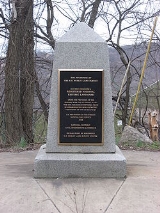
The Beginning Point of the U.S. Public Land Survey is a monument at the border between the U.S. state
s of Ohio
and Pennsylvania
, on the north side of the Ohio River
. It is near the three-way intersection of Ohio, Pennsylvania, and the northern tip of West Virginia
, in both the Pittsburgh metropolitan area and the East Liverpool micropolitan area
. It is significant as being the point from which the Public Land Survey System
was performed, starting in 1785, which would open what was then the Northwest Territory
for settlement. The survey was "the first mathematically designed system and nationally conducted cadastral
survey in any modern country" and is "an object of study by public officials of foreign countries as a basis for land reform
." It was conducted in the late 18th century by Geographer of the U.S. Thomas Hutchins
surveying the Seven Ranges
.
Built in 1881, it was declared a National Historic Landmark
in 1965.
The area that is landmarked includes a part of Ohio and a part of Pennsylvania. A plaque at the site states that the true starting point was 1,112 feet further south. The commemorative site is located about 2 miles east of the center of East Liverpool on Ohio State Route 39
and Pennsylvania Route 68
.
U.S. state
A U.S. state is any one of the 50 federated states of the United States of America that share sovereignty with the federal government. Because of this shared sovereignty, an American is a citizen both of the federal entity and of his or her state of domicile. Four states use the official title of...
s of Ohio
Ohio
Ohio is a Midwestern state in the United States. The 34th largest state by area in the U.S.,it is the 7th‑most populous with over 11.5 million residents, containing several major American cities and seven metropolitan areas with populations of 500,000 or more.The state's capital is Columbus...
and Pennsylvania
Pennsylvania
The Commonwealth of Pennsylvania is a U.S. state that is located in the Northeastern and Mid-Atlantic regions of the United States. The state borders Delaware and Maryland to the south, West Virginia to the southwest, Ohio to the west, New York and Ontario, Canada, to the north, and New Jersey to...
, on the north side of the Ohio River
Ohio River
The Ohio River is the largest tributary, by volume, of the Mississippi River. At the confluence, the Ohio is even bigger than the Mississippi and, thus, is hydrologically the main stream of the whole river system, including the Allegheny River further upstream...
. It is near the three-way intersection of Ohio, Pennsylvania, and the northern tip of West Virginia
West Virginia
West Virginia is a state in the Appalachian and Southeastern regions of the United States, bordered by Virginia to the southeast, Kentucky to the southwest, Ohio to the northwest, Pennsylvania to the northeast and Maryland to the east...
, in both the Pittsburgh metropolitan area and the East Liverpool micropolitan area
East Liverpool, Ohio
As of the census of 2000, there were 13,089 people, 5,261 households, and 3,424 families residing in the city. The population density was 3,010.3 people per square mile . There were 5,743 housing units at an average density of 1,320.8 per square mile...
. It is significant as being the point from which the Public Land Survey System
Public Land Survey System
The Public Land Survey System is a method used in the United States to survey and identify land parcels, particularly for titles and deeds of rural, wild or undeveloped land. Its basic units of area are the township and section. It is sometimes referred to as the rectangular survey system,...
was performed, starting in 1785, which would open what was then the Northwest Territory
Northwest Territory
The Territory Northwest of the River Ohio, more commonly known as the Northwest Territory, was an organized incorporated territory of the United States that existed from July 13, 1787, until March 1, 1803, when the southeastern portion of the territory was admitted to the Union as the state of Ohio...
for settlement. The survey was "the first mathematically designed system and nationally conducted cadastral
Cadastre
A cadastre , using a cadastral survey or cadastral map, is a comprehensive register of the metes-and-bounds real property of a country...
survey in any modern country" and is "an object of study by public officials of foreign countries as a basis for land reform
Land reform
[Image:Jakarta farmers protest23.jpg|300px|thumb|right|Farmers protesting for Land Reform in Indonesia]Land reform involves the changing of laws, regulations or customs regarding land ownership. Land reform may consist of a government-initiated or government-backed property redistribution,...
." It was conducted in the late 18th century by Geographer of the U.S. Thomas Hutchins
Thomas Hutchins
Thomas Hutchins was an American military engineer, cartographer, geographer and surveyor.He joined the militia during the French and Indian War and later took a regular commission with British forces...
surveying the Seven Ranges
Seven Ranges
The Seven Ranges was a land tract in eastern Ohio that was the first tract to be surveyed in what became the Public Land Survey System. The tract is across the northern edge, on the western edge, with the south and east sides along the Ohio River...
.
Built in 1881, it was declared a National Historic Landmark
National Historic Landmark
A National Historic Landmark is a building, site, structure, object, or district, that is officially recognized by the United States government for its historical significance...
in 1965.
The area that is landmarked includes a part of Ohio and a part of Pennsylvania. A plaque at the site states that the true starting point was 1,112 feet further south. The commemorative site is located about 2 miles east of the center of East Liverpool on Ohio State Route 39
Ohio State Route 39
State Route 39 is a primarily east–west running state highway in north-central and northeastern portion of the U.S. state of Ohio. The route runs through seven counties on its approximately trip through the region...
and Pennsylvania Route 68
Pennsylvania Route 68
Pennsylvania Route 68 is a long east–west state highway located in western Pennsylvania in the United States. The western terminus of the route is at the Ohio state line west of Glasgow, where PA 68 continues into Ohio as State Route 39. The eastern terminus is at U.S...
.