

Principal meridian
Encyclopedia
Meridian (geography)
A meridian is an imaginary line on the Earth's surface from the North Pole to the South Pole that connects all locations along it with a given longitude. The position of a point along the meridian is given by its latitude. Each meridian is perpendicular to all circles of latitude...
is an imaginary line on the Earth's surface from the North Pole
North Pole
The North Pole, also known as the Geographic North Pole or Terrestrial North Pole, is, subject to the caveats explained below, defined as the point in the northern hemisphere where the Earth's axis of rotation meets its surface...
to the South Pole
South Pole
The South Pole, also known as the Geographic South Pole or Terrestrial South Pole, is one of the two points where the Earth's axis of rotation intersects its surface. It is the southernmost point on the surface of the Earth and lies on the opposite side of the Earth from the North Pole...
that connects all locations with a given longitude
Longitude
Longitude is a geographic coordinate that specifies the east-west position of a point on the Earth's surface. It is an angular measurement, usually expressed in degrees, minutes and seconds, and denoted by the Greek letter lambda ....
. Each is half of a great circle
Great circle
A great circle, also known as a Riemannian circle, of a sphere is the intersection of the sphere and a plane which passes through the center point of the sphere, as opposed to a general circle of a sphere where the plane is not required to pass through the center...
on the Earth's surface. A principal meridian is the principal north-south line used for survey control in a large region.
Canada
The Dominion Land SurveyDominion Land Survey
The Dominion Land Survey is the method used to divide most of Western Canada into one-square-mile sections for agricultural and other purposes. It is based on the layout of the Public Land Survey System used in the United States, but has several differences...
of Western Canada
Western Canada
Western Canada, also referred to as the Western provinces and commonly as the West, is a region of Canada that includes the four provinces west of the province of Ontario.- Provinces :...
took its origin at the First (or Principal) Meridian, located at 97°27′28.41″ west of Greenwich
Prime Meridian
The Prime Meridian is the meridian at which the longitude is defined to be 0°.The Prime Meridian and its opposite the 180th meridian , which the International Date Line generally follows, form a great circle that divides the Earth into the Eastern and Western Hemispheres.An international...
, just west of Winnipeg, Manitoba.
Six other meridians were designated at four-degree intervals westward, with the seventh located in British Columbia; the second and fourth meridians form the general eastern border and the western border of Saskatchewan
Saskatchewan
Saskatchewan is a prairie province in Canada, which has an area of . Saskatchewan is bordered on the west by Alberta, on the north by the Northwest Territories, on the east by Manitoba, and on the south by the U.S. states of Montana and North Dakota....
.
United States
In the United StatesUnited States
The United States of America is a federal constitutional republic comprising fifty states and a federal district...
Public Land Survey System
Public Land Survey System
The Public Land Survey System is a method used in the United States to survey and identify land parcels, particularly for titles and deeds of rural, wild or undeveloped land. Its basic units of area are the township and section. It is sometimes referred to as the rectangular survey system,...
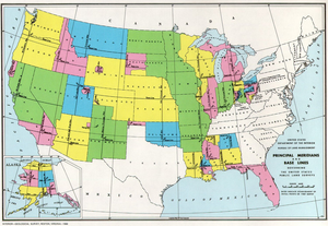
, a principal meridian is the principal north-south line used for survey control in a large region, and which divides townships between east and west. The meridian meets its corresponding baseline
Baseline (surveying)
In the United States Public Land Survey System, a baseline is the principal east-west line that divides survey townships between north and south. The baseline meets its corresponding meridian at the point of origin, or initial point, for the land survey...
at the point of origin, or initial point, for the land survey. For example, the Mount Diablo Meridian
Mount Diablo Meridian
The Mount Diablo Meridian, established in 1851, is the main surveying reference point for much of northern California and Nevada. The initial point is the summit of Mount Diablo.-External links:* *...
, used for surveys in California and Nevada, runs north-south through the summit of Mount Diablo
Mount Diablo State Park
Mount Diablo is a mountain in Contra Costa County, California in the San Francisco Bay Area, located south of Clayton and northeast of Danville. It is an isolated upthrust peak of , visible from most of the San Francisco Bay Area and much of northern California...
.
Often, meridians are marked with roads, such as the Meridian Avenue in San Jose, California
San Jose, California
San Jose is the third-largest city in California, the tenth-largest in the U.S., and the county seat of Santa Clara County which is located at the southern end of San Francisco Bay...
, Meridian Road in Vacaville, California
Vacaville, California
Vacaville, California is a city located in the northeastern portion of the San Francisco Bay Area in Solano County. The city is nearly half way between Sacramento and San Francisco on I-80. It sits approximately from Sacramento, and from San Francisco...
, both on the Mount Diablo Meridian
Mount Diablo Meridian
The Mount Diablo Meridian, established in 1851, is the main surveying reference point for much of northern California and Nevada. The initial point is the summit of Mount Diablo.-External links:* *...
, Meridian Road in Wichita, Kansas
Wichita, Kansas
Wichita is the largest city in the U.S. state of Kansas.As of the 2010 census, the city population was 382,368. Located in south-central Kansas on the Arkansas River, Wichita is the county seat of Sedgwick County and the principal city of the Wichita metropolitan area...
on the Sixth Principal Meridian, and Meridian Avenue in several western Washington counties generally following the Willamette Meridian. Baseline Rd or Base Line St. extends for about 40 miles from Highland, CA (east of San Bernardino) to La Verne, CA where it meets Foothill Blvd.
External links
- The Principal Meridian Project (US)
- History of the Rectangular Survey System Note: this is a large file, approximately 46MB. Searchable PDF prepared by the author, C. A. White.
- Resources page of the U.S. Department of the Interior, Bureau of Land Management