
Cadastre
Encyclopedia
Land registration
Land registration generally describes systems by which matters concerning ownership, possession or other rights in land can be recorded to provide evidence of title, facilitate transactions and to prevent unlawful disposal...
of the metes-and-bounds
Metes and bounds
Metes and bounds is a system or method of describing land, real property or real estate. The system has been used in England for many centuries, and is still used there in the definition of general boundaries...
real property
Real estate
In general use, esp. North American, 'real estate' is taken to mean "Property consisting of land and the buildings on it, along with its natural resources such as crops, minerals, or water; immovable property of this nature; an interest vested in this; an item of real property; buildings or...
of a country. A cadastre commonly includes details of the ownership
Ownership
Ownership is the state or fact of exclusive rights and control over property, which may be an object, land/real estate or intellectual property. Ownership involves multiple rights, collectively referred to as title, which may be separated and held by different parties. The concept of ownership has...
, the tenure
Land tenure
Land tenure is the name given, particularly in common law systems, to the legal regime in which land is owned by an individual, who is said to "hold" the land . The sovereign monarch, known as The Crown, held land in its own right. All private owners are either its tenants or sub-tenants...
, the precise location (some include GPS coordinates), the dimensions (and area), the cultivations if rural, and the value
Value (economics)
An economic value is the worth of a good or service as determined by the market.The economic value of a good or service has puzzled economists since the beginning of the discipline. First, economists tried to estimate the value of a good to an individual alone, and extend that definition to goods...
of individual parcels of land. Cadastres are used by many nations around the world, some in conjunction with other records, such as a title register.
In most countries, legal systems have developed around the original administrative systems and use the cadastre to define the dimensions and location of land parcels described in legal documentation. The cadastre is a fundamental source of data in disputes and lawsuit
Lawsuit
A lawsuit or "suit in law" is a civil action brought in a court of law in which a plaintiff, a party who claims to have incurred loss as a result of a defendant's actions, demands a legal or equitable remedy. The defendant is required to respond to the plaintiff's complaint...
s between landowners.
In the United States
United States
The United States of America is a federal constitutional republic comprising fifty states and a federal district...
, Cadastral Survey within the Bureau of Land Management
Bureau of Land Management
The Bureau of Land Management is an agency within the United States Department of the Interior which administers America's public lands, totaling approximately , or one-eighth of the landmass of the country. The BLM also manages of subsurface mineral estate underlying federal, state and private...
maintains records of all public lands. Such surveys often require detailed investigation of the history of land use, legal accounts, and other documents.
Etymology
The word "cadastre" came into EnglishEnglish language
English is a West Germanic language that arose in the Anglo-Saxon kingdoms of England and spread into what was to become south-east Scotland under the influence of the Anglian medieval kingdom of Northumbria...
through French
French language
French is a Romance language spoken as a first language in France, the Romandy region in Switzerland, Wallonia and Brussels in Belgium, Monaco, the regions of Quebec and Acadia in Canada, and by various communities elsewhere. Second-language speakers of French are distributed throughout many parts...
from Late Latin
Late Latin
Late Latin is the scholarly name for the written Latin of Late Antiquity. The English dictionary definition of Late Latin dates this period from the 3rd to the 6th centuries AD extending in Spain to the 7th. This somewhat ambiguously defined period fits between Classical Latin and Medieval Latin...
capitastrum, a register of the poll tax
Poll tax
A poll tax is a tax of a portioned, fixed amount per individual in accordance with the census . When a corvée is commuted for cash payment, in effect it becomes a poll tax...
, and the Greek
Greek language
Greek is an independent branch of the Indo-European family of languages. Native to the southern Balkans, it has the longest documented history of any Indo-European language, spanning 34 centuries of written records. Its writing system has been the Greek alphabet for the majority of its history;...
κατάστιχον katastikhon, a list or register, from κατὰ στίχον kata stikhon—literally, "down the line," in the sense of "line by line" along the directions and distances between the corners mentioned and marked by monuments in the metes and bounds.
The word forms the adjective cadastral, used in public administration
Public administration
Public Administration houses the implementation of government policy and an academic discipline that studies this implementation and that prepares civil servants for this work. As a "field of inquiry with a diverse scope" its "fundamental goal.....
, primarily for ownership and taxation purposes. The terminology for cadastral divisions may include counties
County
A county is a jurisdiction of local government in certain modern nations. Historically in mainland Europe, the original French term, comté, and its equivalents in other languages denoted a jurisdiction under the sovereignty of a count A county is a jurisdiction of local government in certain...
, parish
Parish (subnational entity)
A parish is an administrative division used by several countries. In the British Isles it is known as a civil parish to distinguish it from the ecclesiastical parish.-External links:* Editorial in The Guardian, 2011-05-16....
es, ridings, hundred
Hundred (division)
A hundred is a geographic division formerly used in England, Wales, Denmark, South Australia, some parts of the United States, Germany , Sweden, Finland and Norway, which historically was used to divide a larger region into smaller administrative divisions...
s, sections
Section (United States land surveying)
In U.S. land surveying under the Public Land Survey System , a section is an area nominally one square mile, containing , with 36 sections making up one survey township on a rectangular grid....
, lots
Lot (real estate)
In real estate, a lot or plot is a tract or parcel of land owned or meant to be owned by some owner. A lot is essentially considered a parcel of real property in some countries or immovable property in other countries...
, blocks and city block
City block
A city block, urban block or simply block is a central element of urban planning and urban design. A city block is the smallest area that is surrounded by streets. City blocks are the space for buildings within the street pattern of a city, they form the basic unit of a city's urban fabric...
s.
Other languages have kept the original t sound in the second syllable (examples: Italian
Italian language
Italian is a Romance language spoken mainly in Europe: Italy, Switzerland, San Marino, Vatican City, by minorities in Malta, Monaco, Croatia, Slovenia, France, Libya, Eritrea, and Somalia, and by immigrant communities in the Americas and Australia...
catasto, German
German language
German is a West Germanic language, related to and classified alongside English and Dutch. With an estimated 90 – 98 million native speakers, German is one of the world's major languages and is the most widely-spoken first language in the European Union....
Kataster, Czech
Czech language
Czech is a West Slavic language with about 12 million native speakers; it is the majority language in the Czech Republic and spoken by Czechs worldwide. The language was known as Bohemian in English until the late 19th century...
katastr, Spanish
Spanish language
Spanish , also known as Castilian , is a Romance language in the Ibero-Romance group that evolved from several languages and dialects in central-northern Iberia around the 9th century and gradually spread with the expansion of the Kingdom of Castile into central and southern Iberia during the...
catastro, Catalan
Catalan language
Catalan is a Romance language, the national and only official language of Andorra and a co-official language in the Spanish autonomous communities of Catalonia, the Balearic Islands and Valencian Community, where it is known as Valencian , as well as in the city of Alghero, on the Italian island...
catastre ). In modern Greek
Greek language
Greek is an independent branch of the Indo-European family of languages. Native to the southern Balkans, it has the longest documented history of any Indo-European language, spanning 34 centuries of written records. Its writing system has been the Greek alphabet for the majority of its history;...
, though, it has been replaced by κτηματολόγιο /ktimato'logio/.
Cadastral surveys
Cadastral surveys document the boundariesBoundary (real estate)
A unit of real estate or immovable property is limited by a legal boundary. The boundary may appear as a discontinuation in the terrain: a ditch, a bank, a hedge, a wall, or similar, but essentially, a legal boundary is a conceptual entity, a social construct, adjunct to the likewise abstract...
of land ownership, by the production of documents, diagrams, sketches, plans (plat
Plat
A plat in the U.S. is a map, drawn to scale, showing the divisions of a piece of land. Other English-speaking countries generally call such documents a cadastral map or plan....
s in USA), charts, and maps. They were originally used to ensure reliable facts for land valuation and taxation. An example from early England
England
England is a country that is part of the United Kingdom. It shares land borders with Scotland to the north and Wales to the west; the Irish Sea is to the north west, the Celtic Sea to the south west, with the North Sea to the east and the English Channel to the south separating it from continental...
is the Domesday Book
Domesday Book
Domesday Book , now held at The National Archives, Kew, Richmond upon Thames in South West London, is the record of the great survey of much of England and parts of Wales completed in 1086...
. Napoleon established a comprehensive cadastral system for France that is regarded as the forerunner of most modern versions.
The Public Lands Survey System is a cadastral survey of what is now the western United States begun in 1785 after international recognition of the United States. The Dominion Land Survey
Dominion Land Survey
The Dominion Land Survey is the method used to divide most of Western Canada into one-square-mile sections for agricultural and other purposes. It is based on the layout of the Public Land Survey System used in the United States, but has several differences...
is a similar cadastral survey conducted in Western Canada begun in 1871 after the creation of the Dominion of Canada in 1867. Both cadastral surveys are made relative to principal meridian
Principal meridian
A meridian is an imaginary line on the Earth's surface from the North Pole to the South Pole that connects all locations with a given longitude. Each is half of a great circle on the Earth's surface...
and baseline
Baseline (surveying)
In the United States Public Land Survey System, a baseline is the principal east-west line that divides survey townships between north and south. The baseline meets its corresponding meridian at the point of origin, or initial point, for the land survey...
s. These cadastral surveys divided the surveyed areas into townships
Survey township
Survey township, sometimes called Congressional township, as used by the United States Public Land Survey System, refers to a square unit of land, that is nominally six miles on a side...
, regions of land approximately six miles square (certain early surveys in Ohio created five mile square townships), and inside townships into sections
Section (United States land surveying)
In U.S. land surveying under the Public Land Survey System , a section is an area nominally one square mile, containing , with 36 sections making up one survey township on a rectangular grid....
, each approximately one mile square. Unlike in Europe this cadastral survey largely preceded settlement and as a result greatly influenced settlement patterns. Most cities and towns feature straight streets and avenues aligned with survey boundaries of townships and sections and spaced at regular intervals corresponding to surveying units such as furlongs. Properties are generally rectangular and often have dimensions measured in fractions or multiples of chains. Land description
Land description
A Land description consists of the written words which delineate a specific piece of real property. Also known as a "Legal Description". In the written transfer of real property, it is universally required that the instrument of conveyance include a written description of the property.- Canada...
s in Western North America are principally based on these land surveys.
Cadastral survey information is often a base element in Geographic/Land Information systems used to assess and manage land and built infrastructure. Such systems are also employed on a variety of other tasks, for example, to track long-term changes over time for geological or ecological studies, where land tenure is a significant part of the scenario.
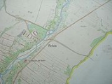
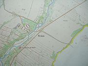
Cadastral map
A cadastral map is a mapMap
A map is a visual representation of an area—a symbolic depiction highlighting relationships between elements of that space such as objects, regions, and themes....
that shows the boundaries
Border
Borders define geographic boundaries of political entities or legal jurisdictions, such as governments, sovereign states, federated states and other subnational entities. Some borders—such as a state's internal administrative borders, or inter-state borders within the Schengen Area—are open and...
and ownership of land parcels. Some cadastral maps show additional details, such as survey district names, unique identifying numbers for parcels, certificate of title numbers, positions of existing structures, section or lot numbers and their respective areas, adjoining and adjacent street names, selected boundary dimensions and references to prior maps.
James C. Scott
James C. Scott
James C. Scott is Sterling Professor of Political Science, formerly Eugene Meyer Professor of Political Science and Anthropology at Yale University. He is also the director of the Program in Agrarian Studies. By training, he is a southeast Asianist.- Research topics :James Scott's work focuses...
, in Seeing Like a State, argues that all maps, but particularly cadastral maps, are designed to make local situations tangible to an outsider, and in doing so, enable states to collect data on their subjects. He sees the origins of this in Early Modern Europe
Early modern Europe
Early modern Europe is the term used by historians to refer to a period in the history of Europe which spanned the centuries between the end of the Middle Ages and the beginning of the Industrial Revolution, roughly the late 15th century to the late 18th century...
, where taxation
Tax
To tax is to impose a financial charge or other levy upon a taxpayer by a state or the functional equivalent of a state such that failure to pay is punishable by law. Taxes are also imposed by many subnational entities...
became more complex. Cadastral maps, he argues, are always a great simplification, but they in themselves help change reality.
See also
- Estate (house)Estate (house)An estate comprises the houses and outbuildings and supporting farmland and woods that surround the gardens and grounds of a very large property, such as a country house or mansion. It is the modern term for a manor, but lacks the latter's now abolished jurisdictional authority...
- PropertyPropertyProperty is any physical or intangible entity that is owned by a person or jointly by a group of people or a legal entity like a corporation...
- Recorder of deedsRecorder of deedsRecorder of deeds is a government office tasked with maintaining public records and documents, especially records relating to real estate ownership that provide persons other than the owner of a property with real rights over that property.-Background:...
(register of deeds) - Cadastral divisions of AustraliaCadastral divisions of AustraliaLands administrative divisions of Australia refers to the parts of Australia which are divided into the cadastral units of counties, parishes, hundreds, and other divisions for the purposes of land ownership...
- KatastralgemeindeKatastralgemeindeA Katastralgemeinde , a German word , is a cadastral subdivision of municipalities in the nations of Austria, Croatia, the Czech Republic, Slovakia, the Italian provinces of South Tyrol, Trentino, Gorizia, Trieste, and in Slovenia.A cadastral community records property ownership in a cadastre,...
- in some German-speaking countries - DefterDefterA Defter was a type of tax register in the Ottoman Empire. The information collected could vary, but tahrir defterleri typically included details of villages, dwellings, household heads , ethnicity/religion , and land use.The defter-i hakâni was a land registry, also used for tax...
(Ottoman Empire)
External links
- Cadastral Template Project, linking to descriptions of national cadastres
- EuroGeographics, representing National Mapping and Cadastral Agencies
- Permanent Committee on Cadastre in the European Union
- http://www.icisociety.ca/
- Surveyor General Branch http://sgb.nrcan.gc.ca/
- Cadastre in Romania