
.gif)
Baseline (surveying)
Encyclopedia
Public Land Survey System
The Public Land Survey System is a method used in the United States to survey and identify land parcels, particularly for titles and deeds of rural, wild or undeveloped land. Its basic units of area are the township and section. It is sometimes referred to as the rectangular survey system,...
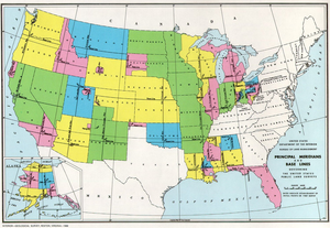
, a baseline is the principal east-west line that divides survey township
Survey township
Survey township, sometimes called Congressional township, as used by the United States Public Land Survey System, refers to a square unit of land, that is nominally six miles on a side...
s between north and south. The baseline meets its corresponding meridian
Meridian (geography)
A meridian is an imaginary line on the Earth's surface from the North Pole to the South Pole that connects all locations along it with a given longitude. The position of a point along the meridian is given by its latitude. Each meridian is perpendicular to all circles of latitude...
at the point of origin, or initial point, for the land survey. For example, the baseline for Nebraska
Nebraska
Nebraska is a state on the Great Plains of the Midwestern United States. The state's capital is Lincoln and its largest city is Omaha, on the Missouri River....
and Kansas
Kansas
Kansas is a US state located in the Midwestern United States. It is named after the Kansas River which flows through it, which in turn was named after the Kansa Native American tribe, which inhabited the area. The tribe's name is often said to mean "people of the wind" or "people of the south...
is shared as the border for both states, at the 40th parallel north
40th parallel north
The 40th parallel north is a circle of latitude that is 40 degrees north of the Earth's equatorial plane. It crosses Europe, the Mediterranean Sea, Asia, the Pacific Ocean, North America, and the Atlantic Ocean....
.
Often, a baseline is marked by other features such as a road or boundary between counties.
"Baseline Road" in the United States
Many communities in the United States have roads that run along survey baselines, many of which are named to reflect that fact. Some examples:- In Little Rock, ArkansasArkansasArkansas is a state located in the southern region of the United States. Its name is an Algonquian name of the Quapaw Indians. Arkansas shares borders with six states , and its eastern border is largely defined by the Mississippi River...
, Baseline Road follows the baseline used by surveyors of the Louisiana PurchaseLouisiana PurchaseThe Louisiana Purchase was the acquisition by the United States of America of of France's claim to the territory of Louisiana in 1803. The U.S...
. - In ColoradoColoradoColorado is a U.S. state that encompasses much of the Rocky Mountains as well as the northeastern portion of the Colorado Plateau and the western edge of the Great Plains...
, Baseline RoadBaseline Road (Colorado)Baseline Road is a major east-west street in Boulder, Colorado that extends east of the city through parts of four counties. The western terminus of Baseline Road is at Flagstaff Mountain in the City of Boulder Mountain Parks. The eastern terminus is at 16800 Watkins Road, about east of Lochbuie...
in BoulderBoulder, ColoradoBoulder is the county seat and most populous city of Boulder County and the 11th most populous city in the U.S. state of Colorado. Boulder is located at the base of the foothills of the Rocky Mountains at an elevation of...
marks the 40th parallel40th parallel northThe 40th parallel north is a circle of latitude that is 40 degrees north of the Earth's equatorial plane. It crosses Europe, the Mediterranean Sea, Asia, the Pacific Ocean, North America, and the Atlantic Ocean....
, or the western extension of the Kansas-Nebraska boundary, which is also the boundary between AdamsAdams County, ColoradoAdams County is the fifth most populous of the 64 counties of the state of Colorado of the United States. The United States Census Bureau estimates that the county population was 441,603 in 2010 census, a 21.4% increase since 2000 census. Adams County is named for Alva Adams, Governor of the...
and WeldWeld County, ColoradoAs of the census of 2000, there were 180,936 people, 63,247 households, and 45,221 families residing in the county. The population density was 45 people per square mile . There were 66,194 housing units at an average density of 17 per square mile...
counties. - In ArizonaArizonaArizona ; is a state located in the southwestern region of the United States. It is also part of the western United States and the mountain west. The capital and largest city is Phoenix...
, the baseline near the PhoenixPhoenix, ArizonaPhoenix is the capital, and largest city, of the U.S. state of Arizona, as well as the sixth most populated city in the United States. Phoenix is home to 1,445,632 people according to the official 2010 U.S. Census Bureau data...
metro area is marked by Baseline Road. - In Southern California, from Highland to San Dimas, the baseline is marked by Baseline Road.
- In Michigan, the baseline for the Michigan Survey forms the boundary between the second and third tiers of counties and in many portions, discontinuous segments of road along the baseline are known as "Baseline Road." 8 Mile Road in the Detroit area runs along the MichiganMichiganMichigan is a U.S. state located in the Great Lakes Region of the United States of America. The name Michigan is the French form of the Ojibwa word mishigamaa, meaning "large water" or "large lake"....
Baseline and was formerly known as "Baseline Road." - Baseline Road in Hillsboro, Oregon, generally follows the Hillsboro CBL (Calibration Base Line).
Canada
In Canadian land surveying, a base line is one of the many principal east-west lines that correspond to 4 tiers of townships (2 tiers north and 2 south). Each base line is about 24 miles apart, with the first base line at the 49th parallel49th parallel north
The 49th parallel north is a circle of latitude that is 49 degrees north of the Earth's equatorial plane. It crosses Europe, Asia, the Pacific Ocean, North America, and the Atlantic Ocean....
, the Western US-Canadian border. It is therefore equivalent to the standard parallel in the US system. In Ontario, a baseline forms a straight line parallel a geographical feature (usually a lake, especially Lake Ontario
Lake Ontario
Lake Ontario is one of the five Great Lakes of North America. It is bounded on the north and southwest by the Canadian province of Ontario, and on the south by the American state of New York. Ontario, Canada's most populous province, was named for the lake. In the Wyandot language, ontarío means...
or Lake Erie
Lake Erie
Lake Erie is the fourth largest lake of the five Great Lakes in North America, and the tenth largest globally. It is the southernmost, shallowest, and smallest by volume of the Great Lakes and therefore also has the shortest average water residence time. It is bounded on the north by the...
) that serves as a reference line for surveying a grid of property lots. The result of this surveying is the concession road and sideline
Concession road
In Upper and Lower Canada, concession roads were laid out by the colonial government through undeveloped land to define lots to be developed; the name comes from a Lower Canadian French term for a row of lots. Concession roads are straight, and follow an approximately square grid, usually oriented...
system in use today.
See also
- Public Land Survey SystemPublic Land Survey SystemThe Public Land Survey System is a method used in the United States to survey and identify land parcels, particularly for titles and deeds of rural, wild or undeveloped land. Its basic units of area are the township and section. It is sometimes referred to as the rectangular survey system,...
(United States) - Dominion Land SurveyDominion Land SurveyThe Dominion Land Survey is the method used to divide most of Western Canada into one-square-mile sections for agricultural and other purposes. It is based on the layout of the Public Land Survey System used in the United States, but has several differences...
(Canada) - Survey townshipSurvey townshipSurvey township, sometimes called Congressional township, as used by the United States Public Land Survey System, refers to a square unit of land, that is nominally six miles on a side...
- Decumanus MaximusDecumanus MaximusIn Roman city planning, a decumanus was an east-west-oriented road in a Roman city, castra , or colonia. The main decumanus was the Decumanus Maximus, which normally connected the Porta Praetoria to the Porta Decumana .This name comes from the fact that the via decumana or decimana In Roman city...
- Principal meridianPrincipal meridianA meridian is an imaginary line on the Earth's surface from the North Pole to the South Pole that connects all locations with a given longitude. Each is half of a great circle on the Earth's surface...
External links
- The Principal Meridian Project (US)
- Resources page of the U.S. Department of the Interior, Bureau of Land Management
- History of the Rectangular Survey System Note: This is a large file, approximately 46MB. Searchable PDF prepared by the author, C. A. White.