

Piri Reis
Encyclopedia
Piri Reis was an Turkish
Ottoman
admiral, geographer and cartographer
born between 1465 and 1470 and died in 1554 or 1555.
He is primarily known today for his maps and charts collected in his Kitab-ı Bahriye (Book of Navigation), a book which contains detailed information on navigation, as well as very accurate charts (for its time) describing the important port
s and cities of the Mediterranean Sea
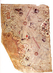
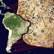
. He gained fame as a cartographer when a small part of his first world map
(prepared in 1513) was discovered in 1929 at the Topkapı Palace
in Istanbul
. His world map is the oldest known Turkish atlas showing the New World
, and one of the oldest maps of America still in existence in the world (the oldest known map of America that is still in existence is the map drawn by Juan de la Cosa
in 1500, which is conserved in the Naval Museum (Museo Naval) of Madrid
, Spain
.) Piri Reis' map is centered on the Sahara
at the latitude of the Tropic of Cancer
.
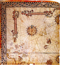
In 1528 Piri Reis drew a second world map, of which a small fragment (showing Greenland
and North America
from Labrador
and Newfoundland in the north to Florida
, Cuba
and parts of Central America
in the south) still survives. According to his imprinting text, he had drawn his maps using about twenty foreign charts and mappae mundi
(Arab, Spanish, Portuguese, Chinese, Indian and Greek) including one of Christopher Columbus
.
 For many years, little was known about the identity of Piri Reis. His name, roughly translated, means Captain Piri. His ethnic origin is debatable, with sources referring to him as of "Christian, possibly Greek"; "Jewish"; or "ethnic Turkish" ancestry.
Today, based on the Ottoman archives
, we know that his full name was "Hadji Ahmed Muhiddin Piri" and that he was born either in Gelibolu
(Gallipoli) on the European part of the Ottoman Empire
(in present-day Turkish Thrace
), or in Karaman
(his father's birth place) in central
Anatolia
,, then the capital of the Beylik of Karaman (annexed by the Ottoman Empire in 1487). The exact date of his birth is unknown. The honorary and informal Islamic
title Hadji
(Turkish
: Hacı) in Piri's (Hadji Ahmed Muhiddin Piri) and his father's (Hadji Mehmed Piri) names indicate that they had completed the Hajj
(Islamic pilgrimage
) by either going to Mecca
themselves, or by officially financing someone who went there and completed the rituals also on their behalf.
He was the son of Hadji Mehmed Piri, and began engaging in government-supported privateering
(a common practice in the Mediterranean Sea among both the Muslim and Christian states of the 15th and 16th centuries) when he was young, in 1481, following his uncle Kemal Reis
, a well-known corsair
and seafarer of the time, who later became a famous admiral
of the Ottoman Navy
. During this period, together with his uncle, he took part in many naval wars of the Ottoman Empire against Spain
, the Republic of Genoa
and the Republic of Venice
, including the First Battle of Lepanto (Battle of Zonchio)
in 1499 and Second Battle of Lepanto (Battle of Modon)
in 1500. When his uncle Kemal Reis died in 1511 (his ship was wrecked by a storm in the Mediterranean Sea, while he was heading to Egypt
), Piri returned to Gelibolu
, where he started working on his studies about navigation.
By 1516, he was again at sea as a ship's captain in the Ottoman fleet. He took part in the 1516–17 Ottoman conquest of Egypt
. In 1522 he participated in the Siege of Rhodes
against the Knights of St. John
, which ended with the island's surrender to the Ottomans on 25 December 1522 and the permanent departure of the Knights from Rhodes on 1 January 1523 (who relocated first (briefly) to Sicily
and later (permanently) to Malta
.) In 1524 he captained the ship that took the Ottoman Grand Vizier
Pargalı İbrahim Pasha
to Egypt.
 In 1547, Piri had risen to the rank of Reis (admiral) as the Commander of the Ottoman Fleet in the Indian Ocean
and Admiral of the Fleet in Egypt, headquartered in Suez
. On 26 February 1548 he recaptured Aden
from the Portuguese
, followed in 1552 by the capture of Muscat
, which Portugal had occupied since 1507, and the strategically important island of Kish
. Turning further east, Piri Reis captured the island of Hormuz
in the Strait of Hormuz
, at the entrance of the Persian Gulf
. When the Portuguese turned their attention to the Persian Gulf, Piri Reis occupied the Qatar
peninsula and the island of Bahrain
to deprive the Portuguese of suitable bases on the Arabian
coast.
He then returned to Egypt, an old man approaching the age of 90. When he refused to support the Ottoman Vali
(Governor) of Basra
, Kubad Pasha, in another campaign against the Portuguese in the northern Persian Gulf, Piri Reis was publicly beheaded in 1554 or 1555.
Several warships and submarines of the Turkish Navy
have been named after Piri Reis.
 Piri Reis is the author of the Kitab-ı Bahriye, one of the most famous pre-modern books of navigation, including a world map. Although he was not an explorer and never sailed to the Atlantic, by making use, according to the imprinting, of about twenty Arab, Spanish, Portuguese, Chinese, Indian and older Greek maps, he managed to give a comprehensive representation of the known world of his era including the recently explored shores of both the African and American continents (on his first World Map of 1513, he imprinted the description "these lands and islands are drawn from the map of Columbus.") In his text, he also wrote that he used the "maps drawn in the time of Alexander the Great" as a source, but most likely he had mistakenly confused the ancient Greek geographer Ptolemy
of the 2nd century AD with the same named General
of Alexander (of six centuries before) since his map is similar with the Jan of Stobnica
famous reproduction map of Ptolemy, printed in 1512. The ancient book had been translated in Turkish after a personal order of Mehmed II
some decades before. The Columbus origin of the Atlantic part of the map is confirmed by the contained errors (such as Columbus’ belief that Cuba was a continental peninsula) since at the time the manuscript produced, the Spaniards were already for two years in Mexico. Apart from the maps, the book also contained detailed information on the major ports, bays, gulfs, capes, peninsulas, islands, straits and ideal shelters of the Mediterranean Sea
, as well as techniques of navigation and navigation-related information on astronomy, together with information about the local people of each country and city and the curious aspects of their culture. There are thirty legends around the world map, twenty-nine in Turkish and one in Arabic, the latter is giving the date as the Muharrem month of 919 AH (corresponding to the Spring of 1513 AD) but most studies have identified the more probable date of completion as 1521. It was revised in 1524-5 with additional information and better-crafted charts in order to be presented as a gift to Suleiman I. The revised edition had a total of 434 pages containing 290 maps.
Kitab-ı Bahriye has two main sections, with the first section dedicated to information about the types of storms; techniques of using a compass; portolan chart
s with detailed information on ports and coastlines; methods of finding direction using the stars; and characteristics of the major oceans and the lands around them. Special emphasis is given to the discoveries in the New World
by Christopher Columbus
and those of Vasco da Gama
and the other Portuguese seamen on their way to India
and the rest of Asia
.
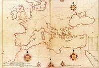 The second section is entirely composed of portolan charts and cruise guides. Each topic contains the map of an island or coastline. In the first book (1521), this section has a total of 132 portolan charts, while the second book (1525) has a total of 210 portolan charts. The second section starts with the description of the Dardanelles Strait and continues with the islands and coastlines of the Aegean Sea
, Ionian Sea
, Adriatic Sea
, Tyrrhenian Sea
, Ligurian Sea
, the French Riviera
, the Balearic Islands
, the coasts of Spain
, the Strait of Gibraltar
, the Canary Islands
, the coasts of North Africa
, Egypt
and the River Nile, the Levant
and the coastline of Anatolia
. This section also includes descriptions and drawings of the famous monuments and buildings in every city, as well as biographic information about Piri Reis who also explains the reasons why he preferred to collect these charts in a book instead of drawing a single map, which would not be able to contain so much information and detail.
A century after Piri's death and during the second half of the 17th century a third version of his book was produced which left the text of the second version unaffected while enriching the cartographical part of the manuscript. It included additional new large-scale maps (mostly copies of the Italian (from Battista Agnese and Jacopo Gastaldi) and Dutch (Abraham Ortelius) works of the previous century.) These maps were much more accurate and depict the Black Sea
which was not comprised in the original.
Copies of the Kitab-ı Bahriye are found in many libraries and museums around the world:
Copies of the first edition (1521) are found in the Topkapı Palace, the Nuruosmaniye Library and the Süleymaniye Library in Istanbul, the Library of the University of Bologna, the National Library of Vienna, the State Library of Dresden, the National Library of France in Paris, the British Museum in London, the Bodleian Library in Oxford and the Walters Art Museum in Baltimore.
Copies of the second edition (1525) are found in the Topkapı Palace, the Köprülüzade Fazıl Ahmed Paşa Library, the Süleymaniye Library and the National Library of France.
Turkish people
Turkish people, also known as the "Turks" , are an ethnic group primarily living in Turkey and in the former lands of the Ottoman Empire where Turkish minorities had been established in Bulgaria, Cyprus, Bosnia and Herzegovina, Georgia, Greece, Kosovo, Macedonia, and Romania...
Ottoman
Ottoman Empire
The Ottoman EmpireIt was usually referred to as the "Ottoman Empire", the "Turkish Empire", the "Ottoman Caliphate" or more commonly "Turkey" by its contemporaries...
admiral, geographer and cartographer
Cartography
Cartography is the study and practice of making maps. Combining science, aesthetics, and technique, cartography builds on the premise that reality can be modeled in ways that communicate spatial information effectively.The fundamental problems of traditional cartography are to:*Set the map's...
born between 1465 and 1470 and died in 1554 or 1555.
He is primarily known today for his maps and charts collected in his Kitab-ı Bahriye (Book of Navigation), a book which contains detailed information on navigation, as well as very accurate charts (for its time) describing the important port
Port
A port is a location on a coast or shore containing one or more harbors where ships can dock and transfer people or cargo to or from land....
s and cities of the Mediterranean Sea
Mediterranean Sea
The Mediterranean Sea is a sea connected to the Atlantic Ocean surrounded by the Mediterranean region and almost completely enclosed by land: on the north by Anatolia and Europe, on the south by North Africa, and on the east by the Levant...
. He gained fame as a cartographer when a small part of his first world map
Piri Reis map
The Piri Reis map is a pre-modern world map compiled in 1513 from military intelligence by the Ottoman-Turkish admiral and cartographer Piri Reis. The half of the map that survives shows the western coasts of Europe and North Africa and the coast of Brazil with reasonable accuracy...
(prepared in 1513) was discovered in 1929 at the Topkapı Palace
Topkapi Palace
The Topkapı Palace is a large palace in Istanbul, Turkey, that was the primary residence of the Ottoman Sultans for approximately 400 years of their 624-year reign....
in Istanbul
Istanbul
Istanbul , historically known as Byzantium and Constantinople , is the largest city of Turkey. Istanbul metropolitan province had 13.26 million people living in it as of December, 2010, which is 18% of Turkey's population and the 3rd largest metropolitan area in Europe after London and...
. His world map is the oldest known Turkish atlas showing the New World
New World
The New World is one of the names used for the Western Hemisphere, specifically America and sometimes Oceania . The term originated in the late 15th century, when America had been recently discovered by European explorers, expanding the geographical horizon of the people of the European middle...
, and one of the oldest maps of America still in existence in the world (the oldest known map of America that is still in existence is the map drawn by Juan de la Cosa
Juan de la Cosa
Juan de la Cosa was a Spanish cartographer, conquistador and explorer. He made the earliest extant European world map to incorporate the territories of the Americas that were discovered in the 15th century, sailed first 3 voyages with Christopher Columbus, and was the owner/captain of the Santa...
in 1500, which is conserved in the Naval Museum (Museo Naval) of Madrid
Madrid
Madrid is the capital and largest city of Spain. The population of the city is roughly 3.3 million and the entire population of the Madrid metropolitan area is calculated to be 6.271 million. It is the third largest city in the European Union, after London and Berlin, and its metropolitan...
, Spain
Spain
Spain , officially the Kingdom of Spain languages]] under the European Charter for Regional or Minority Languages. In each of these, Spain's official name is as follows:;;;;;;), is a country and member state of the European Union located in southwestern Europe on the Iberian Peninsula...
.) Piri Reis' map is centered on the Sahara
Sahara
The Sahara is the world's second largest desert, after Antarctica. At over , it covers most of Northern Africa, making it almost as large as Europe or the United States. The Sahara stretches from the Red Sea, including parts of the Mediterranean coasts, to the outskirts of the Atlantic Ocean...
at the latitude of the Tropic of Cancer
Tropic of Cancer
The Tropic of Cancer, also referred to as the Northern tropic, is the circle of latitude on the Earth that marks the most northerly position at which the Sun may appear directly overhead at its zenith...
.
In 1528 Piri Reis drew a second world map, of which a small fragment (showing Greenland
Greenland
Greenland is an autonomous country within the Kingdom of Denmark, located between the Arctic and Atlantic Oceans, east of the Canadian Arctic Archipelago. Though physiographically a part of the continent of North America, Greenland has been politically and culturally associated with Europe for...
and North America
North America
North America is a continent wholly within the Northern Hemisphere and almost wholly within the Western Hemisphere. It is also considered a northern subcontinent of the Americas...
from Labrador
Labrador
Labrador is the distinct, northerly region of the Canadian province of Newfoundland and Labrador. It comprises the mainland portion of the province, separated from the island of Newfoundland by the Strait of Belle Isle...
and Newfoundland in the north to Florida
Florida
Florida is a state in the southeastern United States, located on the nation's Atlantic and Gulf coasts. It is bordered to the west by the Gulf of Mexico, to the north by Alabama and Georgia and to the east by the Atlantic Ocean. With a population of 18,801,310 as measured by the 2010 census, it...
, Cuba
Cuba
The Republic of Cuba is an island nation in the Caribbean. The nation of Cuba consists of the main island of Cuba, the Isla de la Juventud, and several archipelagos. Havana is the largest city in Cuba and the country's capital. Santiago de Cuba is the second largest city...
and parts of Central America
Central America
Central America is the central geographic region of the Americas. It is the southernmost, isthmian portion of the North American continent, which connects with South America on the southeast. When considered part of the unified continental model, it is considered a subcontinent...
in the south) still survives. According to his imprinting text, he had drawn his maps using about twenty foreign charts and mappae mundi
Mappa mundi
Mappa mundi is a general term used to describe medieval European maps of the world. These maps range in size and complexity from simple schematic maps an inch or less across to elaborate wall maps, the largest of which was 11 ft. in diameter...
(Arab, Spanish, Portuguese, Chinese, Indian and Greek) including one of Christopher Columbus
Christopher Columbus
Christopher Columbus was an explorer, colonizer, and navigator, born in the Republic of Genoa, in northwestern Italy. Under the auspices of the Catholic Monarchs of Spain, he completed four voyages across the Atlantic Ocean that led to general European awareness of the American continents in the...
.
Biography
Today, based on the Ottoman archives
Ottoman Archives
The Ottoman Archives is a collection of historical sources related to the Ottoman Empire. A total of 39 nations hold the collective information, including 19 in the Middle East, 11 in the EU and Balkan states, 3 in the Caucasus, 2 in Central Asia, Cyprus, as well as Israel and Turkey.The main...
, we know that his full name was "Hadji Ahmed Muhiddin Piri" and that he was born either in Gelibolu
Gelibolu
Gelibolu, also known as Gallipoli , is the name of a town and a district in Çanakkale Province of the Marmara region, located in Eastern Thrace in the European part of Turkey on the southern shore of the peninsula named after it on the Dardanelles strait, two miles away from Lapseki on the other...
(Gallipoli) on the European part of the Ottoman Empire
Ottoman Empire
The Ottoman EmpireIt was usually referred to as the "Ottoman Empire", the "Turkish Empire", the "Ottoman Caliphate" or more commonly "Turkey" by its contemporaries...
(in present-day Turkish Thrace
East Thrace
East Thrace or Eastern Thrace , also known as Turkish Thrace, is the part of the modern republic of Turkey that is geographically part of Europe, all in the eastern part of the historical region of Thrace; most of Turkey is in Anatolia, also known as Asia Minor. Turkish Thrace is also called...
), or in Karaman
Karaman
Karaman is a town in south central Turkey, located north of the Taurus Mountains, about south of Konya. It is the capital district of the Karaman Province. According to 2000 census, the population of the province is 231 872 of which 132,064 live in the town of Karaman. The district covers an area...
(his father's birth place) in central
Central Anatolia Region
The Central Anatolia Region is one of Turkey's seven census-defined geographical regions.- Provinces :Total population: 12,105,975* Aksaray Province* Ankara Province* Çankırı Province* Eskişehir Province* Karaman Province* Kayseri Province...
Anatolia
Anatolia
Anatolia is a geographic and historical term denoting the westernmost protrusion of Asia, comprising the majority of the Republic of Turkey...
,, then the capital of the Beylik of Karaman (annexed by the Ottoman Empire in 1487). The exact date of his birth is unknown. The honorary and informal Islamic
Islam
Islam . The most common are and . : Arabic pronunciation varies regionally. The first vowel ranges from ~~. The second vowel ranges from ~~~...
title Hadji
Hajji
Hajji or El-Hajj, is an honorific title given to a Muslim person who has successfully completed the Hajj to Mecca, and is often used to refer to an elder, since it can take time to accumulate the wealth to fund the travel. The title is placed before a person's name...
(Turkish
Turkish language
Turkish is a language spoken as a native language by over 83 million people worldwide, making it the most commonly spoken of the Turkic languages. Its speakers are located predominantly in Turkey and Northern Cyprus with smaller groups in Iraq, Greece, Bulgaria, the Republic of Macedonia, Kosovo,...
: Hacı) in Piri's (Hadji Ahmed Muhiddin Piri) and his father's (Hadji Mehmed Piri) names indicate that they had completed the Hajj
Hajj
The Hajj is the pilgrimage to Mecca, Saudi Arabia. It is one of the largest pilgrimages in the world, and is the fifth pillar of Islam, a religious duty that must be carried out at least once in their lifetime by every able-bodied Muslim who can afford to do so...
(Islamic pilgrimage
Pilgrimage
A pilgrimage is a journey or search of great moral or spiritual significance. Typically, it is a journey to a shrine or other location of importance to a person's beliefs and faith...
) by either going to Mecca
Mecca
Mecca is a city in the Hijaz and the capital of Makkah province in Saudi Arabia. The city is located inland from Jeddah in a narrow valley at a height of above sea level...
themselves, or by officially financing someone who went there and completed the rituals also on their behalf.
He was the son of Hadji Mehmed Piri, and began engaging in government-supported privateering
Privateer
A privateer is a private person or ship authorized by a government by letters of marque to attack foreign shipping during wartime. Privateering was a way of mobilizing armed ships and sailors without having to spend public money or commit naval officers...
(a common practice in the Mediterranean Sea among both the Muslim and Christian states of the 15th and 16th centuries) when he was young, in 1481, following his uncle Kemal Reis
Kemal Reis
Kemal Reis was a Turkish privateer and admiral of the Ottoman Empire. He was also the paternal uncle of the famous Ottoman admiral and cartographer Piri Reis who accompanied him in most of his important naval expeditions....
, a well-known corsair
Corsair
Corsairs were privateers, authorized to conduct raids on shipping of a nation at war with France, on behalf of the French Crown. Seized vessels and cargo were sold at auction, with the corsair captain entitled to a portion of the proceeds...
and seafarer of the time, who later became a famous admiral
Admiral
Admiral is the rank, or part of the name of the ranks, of the highest naval officers. It is usually considered a full admiral and above vice admiral and below admiral of the fleet . It is usually abbreviated to "Adm" or "ADM"...
of the Ottoman Navy
Ottoman Navy
The Ottoman Navy was established in the early 14th century. During its long existence it was involved in many conflicts; refer to list of Ottoman sieges and landings and list of Admirals in the Ottoman Empire for a brief chronology.- Pre-Ottoman:...
. During this period, together with his uncle, he took part in many naval wars of the Ottoman Empire against Spain
Spain
Spain , officially the Kingdom of Spain languages]] under the European Charter for Regional or Minority Languages. In each of these, Spain's official name is as follows:;;;;;;), is a country and member state of the European Union located in southwestern Europe on the Iberian Peninsula...
, the Republic of Genoa
Republic of Genoa
The Most Serene Republic of Genoa |Ligurian]]: Repúbrica de Zêna) was an independent state from 1005 to 1797 in Liguria on the northwestern Italian coast, as well as Corsica from 1347 to 1768, and numerous other territories throughout the Mediterranean....
and the Republic of Venice
Republic of Venice
The Republic of Venice or Venetian Republic was a state originating from the city of Venice in Northeastern Italy. It existed for over a millennium, from the late 7th century until 1797. It was formally known as the Most Serene Republic of Venice and is often referred to as La Serenissima, in...
, including the First Battle of Lepanto (Battle of Zonchio)
Battle of Zonchio
The naval Battle of Zonchio took place on four separate days: August 12, 20, 22 and 25, 1499. It was a part of the Ottoman–Venetian War of 1499–1503...
in 1499 and Second Battle of Lepanto (Battle of Modon)
Battle of Lepanto (1500)
The Battle of Modon took place in August 1500 during the war of 1499–1503 between the Ottoman Empire and the Republic of Venice. The Ottomans, who had won the Battle of Zonchio the previous year, were again victorious under Admiral Kemal Reis.In December 1499 the Venetians attacked Lepanto with...
in 1500. When his uncle Kemal Reis died in 1511 (his ship was wrecked by a storm in the Mediterranean Sea, while he was heading to Egypt
Egypt
Egypt , officially the Arab Republic of Egypt, Arabic: , is a country mainly in North Africa, with the Sinai Peninsula forming a land bridge in Southwest Asia. Egypt is thus a transcontinental country, and a major power in Africa, the Mediterranean Basin, the Middle East and the Muslim world...
), Piri returned to Gelibolu
Gelibolu
Gelibolu, also known as Gallipoli , is the name of a town and a district in Çanakkale Province of the Marmara region, located in Eastern Thrace in the European part of Turkey on the southern shore of the peninsula named after it on the Dardanelles strait, two miles away from Lapseki on the other...
, where he started working on his studies about navigation.
By 1516, he was again at sea as a ship's captain in the Ottoman fleet. He took part in the 1516–17 Ottoman conquest of Egypt
Ottoman–Mamluk War (1516–1517)
The Ottoman–Mamluk War of 1516–1517 was a conflict between the Egyptian Mamluk Sultanate and the Ottoman Empire, which led to the fall of the Mamluk Sultanate and the incorporation of Syria, Egypt and the Arabian Peninsula as provinces of the Ottoman Empire...
. In 1522 he participated in the Siege of Rhodes
Siege of Rhodes (1522)
The Siege of Rhodes of 1522 was the second and ultimately successful attempt by the Ottoman Empire to expel the Knights of Rhodes from their island stronghold and thereby secure Ottoman control of the Eastern Mediterranean. The first siege, in 1480, had been unsuccessful.-Setting:The Knights of St...
against the Knights of St. John
Knights Hospitaller
The Sovereign Military Hospitaller Order of Saint John of Jerusalem of Rhodes and of Malta , also known as the Sovereign Military Order of Malta , Order of Malta or Knights of Malta, is a Roman Catholic lay religious order, traditionally of military, chivalrous, noble nature. It is the world's...
, which ended with the island's surrender to the Ottomans on 25 December 1522 and the permanent departure of the Knights from Rhodes on 1 January 1523 (who relocated first (briefly) to Sicily
Sicily
Sicily is a region of Italy, and is the largest island in the Mediterranean Sea. Along with the surrounding minor islands, it constitutes an autonomous region of Italy, the Regione Autonoma Siciliana Sicily has a rich and unique culture, especially with regard to the arts, music, literature,...
and later (permanently) to Malta
Malta
Malta , officially known as the Republic of Malta , is a Southern European country consisting of an archipelago situated in the centre of the Mediterranean, south of Sicily, east of Tunisia and north of Libya, with Gibraltar to the west and Alexandria to the east.Malta covers just over in...
.) In 1524 he captained the ship that took the Ottoman Grand Vizier
Grand Vizier
Grand Vizier, in Turkish Vezir-i Azam or Sadr-ı Azam , deriving from the Arabic word vizier , was the greatest minister of the Sultan, with absolute power of attorney and, in principle, dismissable only by the Sultan himself...
Pargalı İbrahim Pasha
Pargali Ibrahim Pasha
Pargali Ibrahim Pasha , also known as Frenk Ibrahim Pasha , Makbul Ibrahim Pasha , and referred to him as Maktul Ibrahim Pasha after his murder in the Topkapı Palace, was the first Grand Vizier in the Ottoman Empire appointed by Suleiman the Magnificent...
to Egypt.
Indian Ocean
The Indian Ocean is the third largest of the world's oceanic divisions, covering approximately 20% of the water on the Earth's surface. It is bounded on the north by the Indian Subcontinent and Arabian Peninsula ; on the west by eastern Africa; on the east by Indochina, the Sunda Islands, and...
and Admiral of the Fleet in Egypt, headquartered in Suez
Suez
Suez is a seaport city in north-eastern Egypt, located on the north coast of the Gulf of Suez , near the southern terminus of the Suez Canal, having the same boundaries as Suez governorate. It has three harbors, Adabya, Ain Sokhna and Port Tawfiq, and extensive port facilities...
. On 26 February 1548 he recaptured Aden
Capture of Aden (1548)
The Capture of Aden of 1548 was accomplished when Ottomans under Piri Reis managed to take the harbour of Aden in Yemen from the Portuguese on 26 February 1548....
from the Portuguese
Portugal
Portugal , officially the Portuguese Republic is a country situated in southwestern Europe on the Iberian Peninsula. Portugal is the westernmost country of Europe, and is bordered by the Atlantic Ocean to the West and South and by Spain to the North and East. The Atlantic archipelagos of the...
, followed in 1552 by the capture of Muscat
Capture of Muscat (1552)
The Capture of Muscat occurred in 1552, when an Ottoman fleet under Piri Reis attacked Muscat, modern Oman, and seized the town from the Portuguese...
, which Portugal had occupied since 1507, and the strategically important island of Kish
Kish, Iran
Kish is a resort island in the Persian Gulf. It is part of the Hormozgān Province of Iran. Due to its free trade zone status it is touted as a consumer's paradise, with numerous malls, shopping centres, tourist attractions, and resort hotels. It has an estimated population of 20,000 residents and...
. Turning further east, Piri Reis captured the island of Hormuz
Hormuz Island
Hormuz Island , also spelled Hormoz, is an Iranian island in the Persian Gulf. It is located in the Strait of Hormuz and is part of the Hormozgān Province.-Geography:...
in the Strait of Hormuz
Strait of Hormuz
The Strait of Hormuz is a narrow, strategically important waterway between the Gulf of Oman in the southeast and the Persian Gulf. On the north coast is Iran and on the south coast is the United Arab Emirates and Musandam, an exclave of Oman....
, at the entrance of the Persian Gulf
Persian Gulf
The Persian Gulf, in Southwest Asia, is an extension of the Indian Ocean located between Iran and the Arabian Peninsula.The Persian Gulf was the focus of the 1980–1988 Iran-Iraq War, in which each side attacked the other's oil tankers...
. When the Portuguese turned their attention to the Persian Gulf, Piri Reis occupied the Qatar
Qatar
Qatar , also known as the State of Qatar or locally Dawlat Qaṭar, is a sovereign Arab state, located in the Middle East, occupying the small Qatar Peninsula on the northeasterly coast of the much larger Arabian Peninsula. Its sole land border is with Saudi Arabia to the south, with the rest of its...
peninsula and the island of Bahrain
Bahrain
' , officially the Kingdom of Bahrain , is a small island state near the western shores of the Persian Gulf. It is ruled by the Al Khalifa royal family. The population in 2010 stood at 1,214,705, including 235,108 non-nationals. Formerly an emirate, Bahrain was declared a kingdom in 2002.Bahrain is...
to deprive the Portuguese of suitable bases on the Arabian
Arabian Peninsula
The Arabian Peninsula is a land mass situated north-east of Africa. Also known as Arabia or the Arabian subcontinent, it is the world's largest peninsula and covers 3,237,500 km2...
coast.
He then returned to Egypt, an old man approaching the age of 90. When he refused to support the Ottoman Vali
Wali
Walī , is an Arabic word meaning "custodian", "protector", "sponsor", or authority as denoted by its definition "crown". "Wali" is someone who has "Walayah" over somebody else. For example, in Fiqh the father is wali of his children. In Islam, the phrase ولي الله walīyu 'llāh...
(Governor) of Basra
Basra
Basra is the capital of Basra Governorate, in southern Iraq near Kuwait and Iran. It had an estimated population of two million as of 2009...
, Kubad Pasha, in another campaign against the Portuguese in the northern Persian Gulf, Piri Reis was publicly beheaded in 1554 or 1555.
Several warships and submarines of the Turkish Navy
Turkish Navy
The Turkish Navy is the naval warfare service branch of the Turkish Armed Forces.- Ottoman fleet after Mudros :Following the demise of the Ottoman Empire in the aftermath of World War I, on November 3, 1918, the fleet commander of the Ottoman Navy, Liva Amiral Arif Pasha, ordered all flags to be...
have been named after Piri Reis.
Kitab-ı Bahriye (Book of Navigation): 1521 and 1525
Ptolemy
Claudius Ptolemy , was a Roman citizen of Egypt who wrote in Greek. He was a mathematician, astronomer, geographer, astrologer, and poet of a single epigram in the Greek Anthology. He lived in Egypt under Roman rule, and is believed to have been born in the town of Ptolemais Hermiou in the...
of the 2nd century AD with the same named General
Ptolemy (general)
Ptolemy ; died 309 BC) was a nephew of Antigonus, and who served as a general to Alexander the Great who afterwards became king of Asia....
of Alexander (of six centuries before) since his map is similar with the Jan of Stobnica
Jan of Stobnica
Jan of Stobnica , was a Polish philosopher, scientist and geographer of the early 16th century.-Life:He was educated at the Jagiellonian University , where he taught as professor between 1498 and 1514...
famous reproduction map of Ptolemy, printed in 1512. The ancient book had been translated in Turkish after a personal order of Mehmed II
Mehmed II
Mehmed II , was Sultan of the Ottoman Empire for a short time from 1444 to September 1446, and later from...
some decades before. The Columbus origin of the Atlantic part of the map is confirmed by the contained errors (such as Columbus’ belief that Cuba was a continental peninsula) since at the time the manuscript produced, the Spaniards were already for two years in Mexico. Apart from the maps, the book also contained detailed information on the major ports, bays, gulfs, capes, peninsulas, islands, straits and ideal shelters of the Mediterranean Sea
Mediterranean Sea
The Mediterranean Sea is a sea connected to the Atlantic Ocean surrounded by the Mediterranean region and almost completely enclosed by land: on the north by Anatolia and Europe, on the south by North Africa, and on the east by the Levant...
, as well as techniques of navigation and navigation-related information on astronomy, together with information about the local people of each country and city and the curious aspects of their culture. There are thirty legends around the world map, twenty-nine in Turkish and one in Arabic, the latter is giving the date as the Muharrem month of 919 AH (corresponding to the Spring of 1513 AD) but most studies have identified the more probable date of completion as 1521. It was revised in 1524-5 with additional information and better-crafted charts in order to be presented as a gift to Suleiman I. The revised edition had a total of 434 pages containing 290 maps.
Kitab-ı Bahriye has two main sections, with the first section dedicated to information about the types of storms; techniques of using a compass; portolan chart
Portolan chart
Portolan charts are navigational maps based on realistic descriptions of harbours and coasts. They were first made in the 14th century in Italy, Portugal and Spain...
s with detailed information on ports and coastlines; methods of finding direction using the stars; and characteristics of the major oceans and the lands around them. Special emphasis is given to the discoveries in the New World
New World
The New World is one of the names used for the Western Hemisphere, specifically America and sometimes Oceania . The term originated in the late 15th century, when America had been recently discovered by European explorers, expanding the geographical horizon of the people of the European middle...
by Christopher Columbus
Christopher Columbus
Christopher Columbus was an explorer, colonizer, and navigator, born in the Republic of Genoa, in northwestern Italy. Under the auspices of the Catholic Monarchs of Spain, he completed four voyages across the Atlantic Ocean that led to general European awareness of the American continents in the...
and those of Vasco da Gama
Vasco da Gama
Vasco da Gama, 1st Count of Vidigueira was a Portuguese explorer, one of the most successful in the Age of Discovery and the commander of the first ships to sail directly from Europe to India...
and the other Portuguese seamen on their way to India
India
India , officially the Republic of India , is a country in South Asia. It is the seventh-largest country by geographical area, the second-most populous country with over 1.2 billion people, and the most populous democracy in the world...
and the rest of Asia
Asia
Asia is the world's largest and most populous continent, located primarily in the eastern and northern hemispheres. It covers 8.7% of the Earth's total surface area and with approximately 3.879 billion people, it hosts 60% of the world's current human population...
.
Aegean Sea
The Aegean Sea[p] is an elongated embayment of the Mediterranean Sea located between the southern Balkan and Anatolian peninsulas, i.e., between the mainlands of Greece and Turkey. In the north, it is connected to the Marmara Sea and Black Sea by the Dardanelles and Bosporus...
, Ionian Sea
Ionian Sea
The Ionian Sea , is an arm of the Mediterranean Sea, south of the Adriatic Sea. It is bounded by southern Italy including Calabria, Sicily and the Salento peninsula to the west, southern Albania to the north, and a large number of Greek islands, including Corfu, Zante, Kephalonia, Ithaka, and...
, Adriatic Sea
Adriatic Sea
The Adriatic Sea is a body of water separating the Italian Peninsula from the Balkan peninsula, and the system of the Apennine Mountains from that of the Dinaric Alps and adjacent ranges...
, Tyrrhenian Sea
Tyrrhenian Sea
The Tyrrhenian Sea is part of the Mediterranean Sea off the western coast of Italy.-Geography:The sea is bounded by Corsica and Sardinia , Tuscany, Lazio, Campania, Basilicata and Calabria and Sicily ....
, Ligurian Sea
Ligurian Sea
The Ligurian Sea is an arm of the Mediterranean Sea, between the Italian Riviera and the island of Corsica. The sea is probably named after the ancient Ligures people.-Geography:...
, the French Riviera
French Riviera
The Côte d'Azur, pronounced , often known in English as the French Riviera , is the Mediterranean coastline of the southeast corner of France, also including the sovereign state of Monaco...
, the Balearic Islands
Balearic Islands
The Balearic Islands are an archipelago of Spain in the western Mediterranean Sea, near the eastern coast of the Iberian Peninsula.The four largest islands are: Majorca, Minorca, Ibiza and Formentera. The archipelago forms an autonomous community and a province of Spain with Palma as the capital...
, the coasts of Spain
Spain
Spain , officially the Kingdom of Spain languages]] under the European Charter for Regional or Minority Languages. In each of these, Spain's official name is as follows:;;;;;;), is a country and member state of the European Union located in southwestern Europe on the Iberian Peninsula...
, the Strait of Gibraltar
Strait of Gibraltar
The Strait of Gibraltar is a narrow strait that connects the Atlantic Ocean to the Mediterranean Sea and separates Spain in Europe from Morocco in Africa. The name comes from Gibraltar, which in turn originates from the Arabic Jebel Tariq , albeit the Arab name for the Strait is Bab el-Zakat or...
, the Canary Islands
Canary Islands
The Canary Islands , also known as the Canaries , is a Spanish archipelago located just off the northwest coast of mainland Africa, 100 km west of the border between Morocco and the Western Sahara. The Canaries are a Spanish autonomous community and an outermost region of the European Union...
, the coasts of North Africa
North Africa
North Africa or Northern Africa is the northernmost region of the African continent, linked by the Sahara to Sub-Saharan Africa. Geopolitically, the United Nations definition of Northern Africa includes eight countries or territories; Algeria, Egypt, Libya, Morocco, South Sudan, Sudan, Tunisia, and...
, Egypt
Egypt
Egypt , officially the Arab Republic of Egypt, Arabic: , is a country mainly in North Africa, with the Sinai Peninsula forming a land bridge in Southwest Asia. Egypt is thus a transcontinental country, and a major power in Africa, the Mediterranean Basin, the Middle East and the Muslim world...
and the River Nile, the Levant
Levant
The Levant or ) is the geographic region and culture zone of the "eastern Mediterranean littoral between Anatolia and Egypt" . The Levant includes most of modern Lebanon, Syria, Jordan, Israel, the Palestinian territories, and sometimes parts of Turkey and Iraq, and corresponds roughly to the...
and the coastline of Anatolia
Anatolia
Anatolia is a geographic and historical term denoting the westernmost protrusion of Asia, comprising the majority of the Republic of Turkey...
. This section also includes descriptions and drawings of the famous monuments and buildings in every city, as well as biographic information about Piri Reis who also explains the reasons why he preferred to collect these charts in a book instead of drawing a single map, which would not be able to contain so much information and detail.
A century after Piri's death and during the second half of the 17th century a third version of his book was produced which left the text of the second version unaffected while enriching the cartographical part of the manuscript. It included additional new large-scale maps (mostly copies of the Italian (from Battista Agnese and Jacopo Gastaldi) and Dutch (Abraham Ortelius) works of the previous century.) These maps were much more accurate and depict the Black Sea
Black Sea
The Black Sea is bounded by Europe, Anatolia and the Caucasus and is ultimately connected to the Atlantic Ocean via the Mediterranean and the Aegean seas and various straits. The Bosphorus strait connects it to the Sea of Marmara, and the strait of the Dardanelles connects that sea to the Aegean...
which was not comprised in the original.
Copies of the Kitab-ı Bahriye are found in many libraries and museums around the world:
Copies of the first edition (1521) are found in the Topkapı Palace, the Nuruosmaniye Library and the Süleymaniye Library in Istanbul, the Library of the University of Bologna, the National Library of Vienna, the State Library of Dresden, the National Library of France in Paris, the British Museum in London, the Bodleian Library in Oxford and the Walters Art Museum in Baltimore.
Copies of the second edition (1525) are found in the Topkapı Palace, the Köprülüzade Fazıl Ahmed Paşa Library, the Süleymaniye Library and the National Library of France.
See also
- Piri Reis mapPiri Reis mapThe Piri Reis map is a pre-modern world map compiled in 1513 from military intelligence by the Ottoman-Turkish admiral and cartographer Piri Reis. The half of the map that survives shows the western coasts of Europe and North Africa and the coast of Brazil with reasonable accuracy...
- Ottoman NavyOttoman NavyThe Ottoman Navy was established in the early 14th century. During its long existence it was involved in many conflicts; refer to list of Ottoman sieges and landings and list of Admirals in the Ottoman Empire for a brief chronology.- Pre-Ottoman:...
- Geography and cartography in medieval Islam
- List of cartographers
- Indian Ocean campaignsIndian Ocean campaignsThe Ottoman naval expeditions in the Indian Ocean were a series of Ottoman amphibious operations in the Indian Ocean in the 16th century...
Further reading
- Piri Reis Map and translation of the texts
- İnan, Afet: Life and works of Pirî Reis: the oldest map of America. Ankara 1975.
- Kahle, Paul: Die verschollene Kolumbuskarte von 1498 in einer türkischen Weltkarte von 1513. Berlin/Leipzig 1933. (In German)
- Kahle, Paul (Hrsg.): Piri Re'îs. Bahrîje. Das türkische Segelhandbuch für das Mittelländische Meer vom Jahre 1521. Berlin 1926. (In German)
- McIntosh, Gregory C.: The Piri Reis Map of 1513. Athens and London: University of Georgia Press, 2000.
- Mesenburg, Peter: Kartometrische Untersuchung und Rekonstruktion der Weltkarte des Piri Re`is (1513). In: Cartographica Helvetica, No. 24 (2001), 3–7. (In German)
- Soucek, Svat: Piri Reis and Turkish Mapmaking After Columbus: The Khalili Portolan Atlas. Vol. 2 of Studies in the Khalili Collection. London: The Nour Foundation and Azimuth Editions, 1992; New York: The Nour Foundation, Azimuth Editions, and Oxford University Press, 1996.
- Asensi, Matilde: El origen perdido. Editorial Booket, Barcelona 2005. (In Spanish) 308pp. ISBN 84-08-06185-2. A work of fiction featuring the Piri Reis map, and with the map appearing on the cover.
External links
- The Piri Reis Project, with links to an early edition of A. Afetinan's book and to a reproduction of the Piri Reis Map
- The Piri Reis map (Steven Dutch)
- Paul Lunde, 1992, A Muslim History Of The New World, Saudi Aramco World