

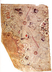
Piri Reis map
Encyclopedia
World map
A world map is a map of the surface of the Earth, which may be made using any of a number of different map projections. A map projection is any method of representing the surface of a sphere or other three-dimensional body on a plane....
compiled in 1513 from military intelligence by the Ottoman
Ottoman Empire
The Ottoman EmpireIt was usually referred to as the "Ottoman Empire", the "Turkish Empire", the "Ottoman Caliphate" or more commonly "Turkey" by its contemporaries...
-Turkish
Turkish people
Turkish people, also known as the "Turks" , are an ethnic group primarily living in Turkey and in the former lands of the Ottoman Empire where Turkish minorities had been established in Bulgaria, Cyprus, Bosnia and Herzegovina, Georgia, Greece, Kosovo, Macedonia, and Romania...
admiral and cartographer Piri Reis
Piri Reis
Piri Reis was an Turkish Ottoman admiral, geographer and cartographer born between 1465 and 1470 and died in 1554 or 1555....
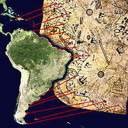
. The half of the map that survives shows the western coasts of Europe
Europe
Europe is, by convention, one of the world's seven continents. Comprising the westernmost peninsula of Eurasia, Europe is generally 'divided' from Asia to its east by the watershed divides of the Ural and Caucasus Mountains, the Ural River, the Caspian and Black Seas, and the waterways connecting...
and North Africa
North Africa
North Africa or Northern Africa is the northernmost region of the African continent, linked by the Sahara to Sub-Saharan Africa. Geopolitically, the United Nations definition of Northern Africa includes eight countries or territories; Algeria, Egypt, Libya, Morocco, South Sudan, Sudan, Tunisia, and...
and the coast of Brazil
Brazil
Brazil , officially the Federative Republic of Brazil , is the largest country in South America. It is the world's fifth largest country, both by geographical area and by population with over 192 million people...
with reasonable accuracy. Various Atlantic islands including the Azores
Azores
The Archipelago of the Azores is composed of nine volcanic islands situated in the middle of the North Atlantic Ocean, and is located about west from Lisbon and about east from the east coast of North America. The islands, and their economic exclusion zone, form the Autonomous Region of the...
and Canary Islands
Canary Islands
The Canary Islands , also known as the Canaries , is a Spanish archipelago located just off the northwest coast of mainland Africa, 100 km west of the border between Morocco and the Western Sahara. The Canaries are a Spanish autonomous community and an outermost region of the European Union...
are depicted, as is the mythical island of Antillia
Antillia
Antillia is a legendary island that was reputed, during the 15th century age of exploration, to lie in the Atlantic Ocean, far to the west of Portugal and Spain...
and possibly Japan
Japan
Japan is an island nation in East Asia. Located in the Pacific Ocean, it lies to the east of the Sea of Japan, China, North Korea, South Korea and Russia, stretching from the Sea of Okhotsk in the north to the East China Sea and Taiwan in the south...
. The historical importance of the map lies in its demonstration of the extent of exploration of the New World by approximately 1510, perhaps before others. It used 10 Arabian sources, 4 Indian maps sourced from Portuguese and one map of Columbus.
Description
The map is the extant western third of a world map drawn on gazelleGazelle
A gazelle is any of many antelope species in the genus Gazella, or formerly considered to belong to it. Six species are included in two genera, Eudorcas and Nanger, which were formerly considered subgenera...
skin, with dimensions reported as 90 cm × 63 cm, 86 cm × 60 cm, 90 cm × 65 cm, 85 cm × 60 cm, 87 cm × 63 cm, and 86 cm × 62 cm. These discrepancies are largely due to the damaged corner. The surviving portion primarily details the western coast of Africa
Africa
Africa is the world's second largest and second most populous continent, after Asia. At about 30.2 million km² including adjacent islands, it covers 6% of the Earth's total surface area and 20.4% of the total land area...
and the eastern coast of South America
South America
South America is a continent situated in the Western Hemisphere, mostly in the Southern Hemisphere, with a relatively small portion in the Northern Hemisphere. The continent is also considered a subcontinent of the Americas. It is bordered on the west by the Pacific Ocean and on the north and east...
. The map was signed by Piri Reis
Piri Reis
Piri Reis was an Turkish Ottoman admiral, geographer and cartographer born between 1465 and 1470 and died in 1554 or 1555....
, an Ottoman-Turkish
Ottoman Empire
The Ottoman EmpireIt was usually referred to as the "Ottoman Empire", the "Turkish Empire", the "Ottoman Caliphate" or more commonly "Turkey" by its contemporaries...
admiral
Admiral
Admiral is the rank, or part of the name of the ranks, of the highest naval officers. It is usually considered a full admiral and above vice admiral and below admiral of the fleet . It is usually abbreviated to "Adm" or "ADM"...
, geographer and cartographer
Cartography
Cartography is the study and practice of making maps. Combining science, aesthetics, and technique, cartography builds on the premise that reality can be modeled in ways that communicate spatial information effectively.The fundamental problems of traditional cartography are to:*Set the map's...
, and dated to the month of Muharram
Muharram
Muharram is the first month of the Islamic calendar. It is one of the four sacred months of the year in which fighting is prohibited...
in the Islamic year
Islamic calendar
The Hijri calendar , also known as the Muslim calendar or Islamic calendar , is a lunar calendar consisting of 12 lunar months in a year of 354 or 355 days. It is used to date events in many Muslim countries , and used by Muslims everywhere to determine the proper day on which to celebrate Islamic...
919 AH, equivalent to 1513 AD. It was presented to Ottoman Sultan Selim I
Selim I
Selim I, Yavuz Sultân Selim Khan, Hâdim-ül Haramain-ish Sharifain , nicknamed Yavuz "the Stern" or "the Steadfast", but often rendered in English as "the Grim" , was the Sultan of the Ottoman Empire from 1512 to...
in 1517. In the map's legend, Piri inscribed that the map was based on about twenty charts and mappae mundi
Mappa mundi
Mappa mundi is a general term used to describe medieval European maps of the world. These maps range in size and complexity from simple schematic maps an inch or less across to elaborate wall maps, the largest of which was 11 ft. in diameter...
. According to Piri, these maps included eight Ptolemaic maps constructed during the era of Alexander the Great, an Arab
Arab
Arab people, also known as Arabs , are a panethnicity primarily living in the Arab world, which is located in Western Asia and North Africa. They are identified as such on one or more of genealogical, linguistic, or cultural grounds, with tribal affiliations, and intra-tribal relationships playing...
ic map of India
India
India , officially the Republic of India , is a country in South Asia. It is the seventh-largest country by geographical area, the second-most populous country with over 1.2 billion people, and the most populous democracy in the world...
, four newly drawn Portuguese
Portugal
Portugal , officially the Portuguese Republic is a country situated in southwestern Europe on the Iberian Peninsula. Portugal is the westernmost country of Europe, and is bordered by the Atlantic Ocean to the West and South and by Spain to the North and East. The Atlantic archipelagos of the...
maps from Sindh, Pakistan and a map by Christopher Columbus
Christopher Columbus
Christopher Columbus was an explorer, colonizer, and navigator, born in the Republic of Genoa, in northwestern Italy. Under the auspices of the Catholic Monarchs of Spain, he completed four voyages across the Atlantic Ocean that led to general European awareness of the American continents in the...
of the western lands. From Inscription 6 on the map:
From eight Jaferyas of that kind and one Arabic map of Hind [India], and from four newly drawn Portuguese maps which show the countries of Sind [now in modern day PakistanPakistanPakistan , officially the Islamic Republic of Pakistan is a sovereign state in South Asia. It has a coastline along the Arabian Sea and the Gulf of Oman in the south and is bordered by Afghanistan and Iran in the west, India in the east and China in the far northeast. In the north, Tajikistan...] , Hind and Çin [China] geometrically drawn, and also from a map drawn by Qulūnbū [Columbus] in the western region, I have extracted it. By reducing all these maps to one scale this final form was arrived at, so that this map of these lands is regarded by seamen as accurate and as reliable as the accuracy and reliability of the Seven SeasSeven SeasThe phrase "Seven Seas" can refer either to a particular set of seven seas or to a great expanse of water in general. Today in modern times, this also includes the four oceans, and three large seas...
on the aforesaid maps."
There is some scholarly debate over whether the 20 charts and mappae mundi in Piri's inscriptions includes the eight Ptolemaic maps, the four Portuguese maps, the Arabic map and the Columbus map. From one perspective, the number of charts and mappae mundi used by Piri equals 20, while in the other, it could mean a total of 34. Some have claimed that the source maps were found in the ancient Library of Alexandria
Library of Alexandria
The Royal Library of Alexandria, or Ancient Library of Alexandria, in Alexandria, Egypt, was the largest and most significant great library of the ancient world. It flourished under the patronage of the Ptolemaic dynasty and functioned as a major center of scholarship from its construction in the...
, based on Piri's allusions to Alexander the Great, the founder of Alexandria
Alexandria
Alexandria is the second-largest city of Egypt, with a population of 4.1 million, extending about along the coast of the Mediterranean Sea in the north central part of the country; it is also the largest city lying directly on the Mediterranean coast. It is Egypt's largest seaport, serving...
, Ptolemy I, who ruled Alexandria in the 4th century BC, and Claudius Ptolemy, the Greek geographer and cartographer who lived in Alexandria during the second century AD.
History
The map was discovered serendipitously on 9 October 1929, through the philological work of the German theologian, Gustav Adolf DeissmannGustav Adolf Deissmann
Gustav Adolf Deissmann was a German Protestant theologian, best known for his leading work on the Greek language used in the New Testament, which he showed was the koine, or commonly used tongue of the Hellenistic world of that time.-Life:Deissmann was professor of theology at the Ruprecht Karl...
(1866–1937). He had been commissioned by the Turkish Ministry of Education to catalogue the Topkapı Sarayı library's non-Islamic items. At Deissmann's request to search the palace for old maps and charts, the director Halil Edhem (1861–1938) managed to find some disregarded bundles of material, which he handed over to Deissmann. Realizing that the map might be a unique find, Deissmann showed it to the orientalist Paul Kahle who identified it as a map drawn by Piri Reis.
The discovery caused an international sensation, as it represented the only then known copy of a world map of Christopher Columbus (1451–1506), and was the only 16th century map that showed South America in its proper longitudinal
Longitude
Longitude is a geographic coordinate that specifies the east-west position of a point on the Earth's surface. It is an angular measurement, usually expressed in degrees, minutes and seconds, and denoted by the Greek letter lambda ....
position in relation to Africa. Geographers had spent several centuries unsuccessfully searching for a "lost map of Columbus" that was supposedly drawn while he was in the West Indies.
After reading about the map's discovery in The Illustrated London News, United States
United States
The United States of America is a federal constitutional republic comprising fifty states and a federal district...
Secretary of State
United States Secretary of State
The United States Secretary of State is the head of the United States Department of State, concerned with foreign affairs. The Secretary is a member of the Cabinet and the highest-ranking cabinet secretary both in line of succession and order of precedence...
Henry L. Stimson
Henry L. Stimson
Henry Lewis Stimson was an American statesman, lawyer and Republican Party politician and spokesman on foreign policy. He twice served as Secretary of War 1911–1913 under Republican William Howard Taft and 1940–1945, under Democrat Franklin D. Roosevelt. In the latter role he was a leading hawk...
contacted the United States Ambassador to Turkey
United States Ambassador to Turkey
The United States of America has maintained many high level contacts with Turkey since the nineteenth century.-Chargé d'Affaires:*George W. Erving *David Porter -Minister Resident:*David Porter *Dabney Smith Carr...
Charles H. Sherrill and requested that an investigation be launched to find the Columbus source map, which he believed may have been in Turkey. In turn, the Turkish government complied with Stimson's request, but they were unsuccessful in locating any of the source maps.
The Piri Reis map is currently located in the Library of the Topkapı Palace in Istanbul
Istanbul
Istanbul , historically known as Byzantium and Constantinople , is the largest city of Turkey. Istanbul metropolitan province had 13.26 million people living in it as of December, 2010, which is 18% of Turkey's population and the 3rd largest metropolitan area in Europe after London and...
, Turkey
Turkey
Turkey , known officially as the Republic of Turkey , is a Eurasian country located in Western Asia and in East Thrace in Southeastern Europe...
, but is not usually on display to the public.
The map was depicted on the reverse
Obverse and reverse
Obverse and its opposite, reverse, refer to the two flat faces of coins and some other two-sided objects, including paper money, flags , seals, medals, drawings, old master prints and other works of art, and printed fabrics. In this usage, obverse means the front face of the object and reverse...
of the Turkish 10 million lira
Turkish lira
The Turkish lira is the currency of Turkey and the de facto independent state of the Turkish Republic of Northern Cyprus. The lira is subdivided into 100 kuruş...
banknote of 1999-2005 and of the new 10 lira banknote of 2005-2009.
Analysis
Charles Hapgood
Charles HapgoodCharles Hapgood
Charles Hutchins Hapgood was an American college professor and author who became one of the best known advocates of a pseudo-historical claim of a rapid and recent pole shift with catastrophic results.-Biography:...
began studying the map in the middle of the 20th century and published the book Maps of the Ancient Sea Kings in 1966.
Hapgood claims this and other maps support a theory of global exploration by a pre-classical undiscovered civilization. He supports this with an analysis of the mathematics of ancient maps and of their accuracy, which he says surpassed instrumentation available at the time of the map's drafting.
Hapgood argued that owing to the map being assembled from components, the Caribbean section was rotated nearly 90º from the top of South America. He attributed this to either copying from a polar projection, or to fit in the space available by hinging the map at that location and giving it an "alternate north", of which other examples are known in maps of the era.
Gregory McIntosh
Gregory McIntosh, a historian of cartography, has examined the Piri Reis map in depth and published his research in the book The Piri Reis Map of 1513 (Athens and London: University of Georgia Press, 2000).He claims that the depiction of the Caribbean was developed from at least one of Columbus's maps. Hispaniola
Hispaniola
Hispaniola is a major island in the Caribbean, containing the two sovereign states of the Dominican Republic and Haiti. The island is located between the islands of Cuba to the west and Puerto Rico to the east, within the hurricane belt...
is depicted with a north-south axis similar to depictions of Japan
Japan
Japan is an island nation in East Asia. Located in the Pacific Ocean, it lies to the east of the Sea of Japan, China, North Korea, South Korea and Russia, stretching from the Sea of Okhotsk in the north to the East China Sea and Taiwan in the south...
on maps of the same era. At the time it was widely believed that the east coast of the Americas was in fact that of Asia. Columbus believed that Japan and Hispaniola were actually the same island and Cuba
Cuba
The Republic of Cuba is an island nation in the Caribbean. The nation of Cuba consists of the main island of Cuba, the Isla de la Juventud, and several archipelagos. Havana is the largest city in Cuba and the country's capital. Santiago de Cuba is the second largest city...
was part of a mainland. The mainland in the extreme northwest is labeled with place-names from Columbus's voyages along the coasts of Cuba. McIntosh claims the map shows double sets of Virgin Islands
Virgin Islands
The Virgin Islands are the western island group of the Leeward Islands, which are the northern part of the Lesser Antilles, which form the border between the Caribbean Sea and the Atlantic Ocean...
because Piri Reis took them from two maps. Many of the names of ports and geographic points are found in Columbus's written texts.
McIntosh, in comparing the Piri Reis map to several other portolan-style maps of the era, found that
The Piri Reis map is not the most accurate map of the sixteenth century, as has been claimed, there being many, many world maps produced in the remaining eighty-seven years of that century that far surpass it in accuracy. The Ribero maps of the 1520s and 1530s, the Ortelius map of 1570, and the WrightEdward Wright (mathematician)Edward Wright was an English mathematician and cartographer noted for his book Certaine Errors in Navigation , which for the first time explained the mathematical basis of the Mercator projection, and set out a reference table giving the linear scale multiplication factor as a function of...
-MolyneuxEmery MolyneuxEmery Molyneux was an English Elizabethan maker of globes, mathematical instruments and ordnance. His terrestrial and celestial globes, first published in 1592, were the first to be made in England and the first to be made by an Englishman....
map of 1599 (‘the best map of the sixteenth century’) are only a few better-known examples.
McIntosh intended for this conclusion to be part of a direct challenge to Charles Hapgood's theory about the historical roots of the map. McIntosh found that many of Hapgood's claims were problematic and that, in many cases, the accuracy of the map as Hapgood presents it is exaggerated and that some figures, such as Cuba, Hispaniola, part of Newfoundland, and others have to be rotated or distorted to appear accurately drawn.
Gavin Menzies
Amateur historian Gavin MenziesGavin Menzies
Rowan Gavin Paton Menzies is a retired British submarine lieutenant-commander and author. He is best known for his controversial book 1421: The Year China Discovered the World, in which he asserts that the fleets of Chinese Admiral Zheng He visited the Americas prior to European explorer...
claims in his book 1421: The Year China Discovered America that the southern landmass is indeed the Antarctic coastline and was based on earlier Chinese maps. According to Menzies, Admiral Hong Bao
Hong Bao
Hong Bao was a Chinese eunuch sent on overseas diplomatic missions during the reign of Ming emperors Yongle and Xuande. He is best known as the commander of one of the detached squadrons of Zheng He's fleet during the Seventh Voyage of this fleet to the Indian Ocean .-Early career:According to the...
charted the coast over 70 years before Columbus as part of a larger expedition under the famous Chinese explorer and admiral Zheng He
Zheng He
Zheng He , also known as Ma Sanbao and Hajji Mahmud Shamsuddin was a Hui-Chinese mariner, explorer, diplomat and fleet admiral, who commanded voyages to Southeast Asia, South Asia, the Middle East, and East Africa, collectively referred to as the Voyages of Zheng He or Voyages of Cheng Ho from...
to bring the world under China's tribute system.
Gregory McIntosh and other cartographers and historians who have examined the map in detail believe the resemblance of the coastline to the actual coast of Antarctica to be tenuous. For centuries before the actual discovery of Antarctica, cartographers had been depicting a massive southern landmass on global maps based on the theoretical assumption by some that one must exist, if only to balance the landmass of the North. It was widely believed that South America and, once its northern coastline was discovered, Australia
Australia
Australia , officially the Commonwealth of Australia, is a country in the Southern Hemisphere comprising the mainland of the Australian continent, the island of Tasmania, and numerous smaller islands in the Indian and Pacific Oceans. It is the world's sixth-largest country by total area...
, must be joined to this land mass, which was thought to be very much bigger than the real Antarctica. This theoretical southern continent, the Great Southern Land or Terra Australis Incognita (literally Unknown Southern Land), in various configurations, was usually shown on maps until the eighteenth century. An alternate view is that the "Antarctic" coast is simply the eastern coastline of South America skewed to align east-west due to the inaccurate measurement of longitude or to fit it on the page.
Hapgood suggests that the Antarctic section of the map was copied at an incorrect scale to the rest of the map and resulted in the distortion and enlargement of the continent on several ancient maps. This would explain why there is no waterway between South America and Antarctica. He suggests several points of continuity between the Piri Reis Map and modern maps of the continent below the ice sheet
Ice sheet
An ice sheet is a mass of glacier ice that covers surrounding terrain and is greater than 50,000 km² , thus also known as continental glacier...
s. Since the Antarctic continent was not officially sighted until 1820
History of Antarctica
The history of Antarctica emerges from early Western theories of a vast continent, known as Terra Australis, believed to exist in the far south of the globe...
and its full coastline was not known until much later; this claim, if true, would require major revisions to the history of exploration, settlement, evolution, and technological advancements of the time.
Strait of Magellan
The Strait of Magellan comprises a navigable sea route immediately south of mainland South America and north of Tierra del Fuego...
, and the Falkland Islands
Falkland Islands
The Falkland Islands are an archipelago in the South Atlantic Ocean, located about from the coast of mainland South America. The archipelago consists of East Falkland, West Falkland and 776 lesser islands. The capital, Stanley, is on East Falkland...
.
See also
- Geography in medieval Islam
- Ancient world mapsAncient world mapsEarly world maps cover depictions of the world from the Iron Age to the Age of Discovery and the emergence of modern geography during the early modern period.-Babylonian Imago Mundi Early world maps cover depictions of the world from the Iron Age to the Age of Discovery and the emergence of modern...
- World mapWorld mapA world map is a map of the surface of the Earth, which may be made using any of a number of different map projections. A map projection is any method of representing the surface of a sphere or other three-dimensional body on a plane....
- Waldseemüller mapWaldseemüller mapThe Waldseemüller map, Universalis Cosmographia, is a printed wall map of the world by German cartographer Martin Waldseemüller, originally published in April 1507. It is known as the first map to use the name "America". The map is drafted on a modification of Ptolemy's second projection, expanded...
- Johannes Schöner globes, made in 1515 and 1520. Also shows a Southern Continent at the South Pole.
External links
- Turkey in Maps: The Piri Reis margin notes, translation from The Oldest Map of America (Afet Inan, Ankara, 1954).
- Charles Hapgood commentary on the Piri Reis map, photocopied from Maps of the Ancient Sea Kings
- Steven Dutch, University of Wisconsin: debunking Piri Reis pseudo-scholarship
- Sacred Text Archive: pseudo-scholarship about an Ice Age civilization, translation of the map commentary.
- "Piri Reis and the Columbian Theory" by Paul Lunde: text from Aramco World Magazine (Jan-Feb 1980). Citat: "...There may, in fact, be an even simpler explanation of the presence of "Antarctica" on the Piri Reis map..."
- Fingerprints of the Gods (2001) text. Citat: "...William Miller wrote:...The examinations that I have made of it show all sorts of errors that certainly falsify any claim of unusual accuracy for this map..."
- The Mysterious Origins of Man: The Oronteus Finaeus Map of 1532, by Paul Heinrich: the Oronteus map and Creationism
- The Mysteries of the Piri Reis Map: by Diego Cuoghi. On the Piri Reis, Oronteus, and Philippe Buache maps; comparison to other 16th c. maps of America and Asia, debunking the Antarctica claims.
- Ottoman-Turkish Historical Maps: includes a large (1 MB) but low-resolution image of the Piri Reis map (not as clear as Wikipedia's image)