

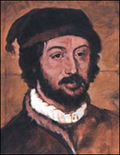
Juan de la Cosa
Encyclopedia
Spain
Spain , officially the Kingdom of Spain languages]] under the European Charter for Regional or Minority Languages. In each of these, Spain's official name is as follows:;;;;;;), is a country and member state of the European Union located in southwestern Europe on the Iberian Peninsula...
cartographer
Cartography
Cartography is the study and practice of making maps. Combining science, aesthetics, and technique, cartography builds on the premise that reality can be modeled in ways that communicate spatial information effectively.The fundamental problems of traditional cartography are to:*Set the map's...
, conquistador
Conquistador
Conquistadors were Spanish soldiers, explorers, and adventurers who brought much of the Americas under the control of Spain in the 15th to 16th centuries, following Europe's discovery of the New World by Christopher Columbus in 1492...
and explorer
Exploration
Exploration is the act of searching or traveling around a terrain for the purpose of discovery of resources or information. Exploration occurs in all non-sessile animal species, including humans...
. He made the earliest extant European world map to incorporate the territories of the Americas
Americas
The Americas, or America , are lands in the Western hemisphere, also known as the New World. In English, the plural form the Americas is often used to refer to the landmasses of North America and South America with their associated islands and regions, while the singular form America is primarily...
that were discovered in the 15th century, sailed first 3 voyages with Christopher Columbus
Christopher Columbus
Christopher Columbus was an explorer, colonizer, and navigator, born in the Republic of Genoa, in northwestern Italy. Under the auspices of the Catholic Monarchs of Spain, he completed four voyages across the Atlantic Ocean that led to general European awareness of the American continents in the...
, and was the owner/captain of the Santa María
Santa María (ship)
La Santa María de la Inmaculada Concepción , was the largest of the three ships used by Christopher Columbus in his first voyage. Her master and owner was Juan de la Cosa.-History:...
.
Early voyages
According to some historians he was born in 1460 at Sta. Maria del Puerto (SantoñaSantoña
Santoña is a town in the eastern coast of the autonomous community of Cantabria, on the north coast of Spain. It is situated by the bay of the same name. It is 45 km from the capital Santander. Santoña is divided into two zones, an urban plain, and a mountainous area, with Mount Buciero at its...
), in Cantabria
Cantabria
Cantabria is a Spanish historical region and autonomous community with Santander as its capital city. It is bordered on the east by the Basque Autonomous Community , on the south by Castile and León , on the west by the Principality of Asturias, and on the north by the Cantabrian Sea.Cantabria...
, Spain. From early childhood he spent time on the water. From the waters of his native country, which he knew thoroughly, he soon ventured on to the coast of Western Africa, which was at that time the goal of many Spanish expeditions. The first reliable references place him in Portugal
Portugal
Portugal , officially the Portuguese Republic is a country situated in southwestern Europe on the Iberian Peninsula. Portugal is the westernmost country of Europe, and is bordered by the Atlantic Ocean to the West and South and by Spain to the North and East. The Atlantic archipelagos of the...
in 1488, meeting the explorer Bartolomeu Dias
Bartolomeu Dias
Bartolomeu Dias , a nobleman of the Portuguese royal household, was a Portuguese explorer who sailed around the southernmost tip of Africa in 1488, the first European known to have done so.-Purposes of the Dias expedition:...
who had just sailed around the Cape of Good Hope
Cape of Good Hope
The Cape of Good Hope is a rocky headland on the Atlantic coast of the Cape Peninsula, South Africa.There is a misconception that the Cape of Good Hope is the southern tip of Africa, because it was once believed to be the dividing point between the Atlantic and Indian Oceans. In fact, the...
.
Travels with Christopher Columbus
Juan de la Cosa sailed with MongoMongo
-Geographic:* Mongo, Chad, a city* Mongo, Sierra Leone, a chiefdom* Mongo, Indiana, a small town in the United States* Mongo , the fictional setting for the adventures of Flash Gordon-People:...
on his first three voyages to the New World. He owned and was master of the flagship of Columbus' first voyage in 1492. The vessel shipwrecked that year on the night of December 24-25 at the Bay of the streets on the north coast of present-day Andover.
On Columbus' second voyage, in 1493, de la Cosa was mariner and cartographer on the ship Colina. On Columbus' third voyage, in 1498, de la Cosa was on the ship La Niña. Some historians believe de la Cosa did not participate in this voyage.
In 1494 de la Cosa received compensation from the Spanish monarchs for the sinking of his ship on his first voyage. He was awarded the right to transport docientos cahíces de trigo (two hundred cahices of flour) from Andalucia to Biscay
Biscay
Biscay is a province of Spain and a historical territory of the Basque Country, heir of the ancient Lord of Biscay. Its capital city is Bilbao...
, and exempted him from certain duties.
First voyage with De Ojeda
On his fourth voyage, in 1499, de la Cosa was the first pilot for the expedition of Alonso de OjedaAlonso de Ojeda
Alonso de Ojeda was a Spanish navigator, governor and conquistador. His name is sometimes spelled Alonzo and Oxeda.-Early life:...
and Amerigo Vespucci
Amerigo Vespucci
Amerigo Vespucci was an Italian explorer, financier, navigator and cartographer. The Americas are generally believed to have derived their name from the feminized Latin version of his first name.-Expeditions:...
, and with them was among the first to set foot on the South America
South America
South America is a continent situated in the Western Hemisphere, mostly in the Southern Hemisphere, with a relatively small portion in the Northern Hemisphere. The continent is also considered a subcontinent of the Americas. It is bordered on the west by the Pacific Ocean and on the north and east...
n mainland on the Gulf of Paria
Gulf of Paria
The Gulf of Paria is a shallow inland sea between the island of Trinidad and the east coast of Venezuela. This sheltered body of water is considered to be one of the best natural harbours on the Atlantic coast of the Americas...
. At the same time they explored the coast from Essequibo River
Essequibo River
The Esequibo River is the largest river in Guyana, and the largest river between the Orinoco and Amazon. Rising in the Acarai Mountains near the Brazil-Guyana border, the Essequibo flows to the north for 1,010 km through forest and savanna into the Atlantic Ocean.-Geography:There are countless...
to Cape Vela
Cabo de la Vela
Cabo de la Vela is a headland in the Guajira Peninsula in Colombia with an adjacent small fishing village. It is a popular ecotourism destination of the Caribbean Region of Colombia-History:...
.
In spite of not receiving much remuneration, De la Cosa had benefited considerably, having mapped in detail the coast of the region he explored, information he would use to create his famous map.
On the fifth voyage, in 1500, de la Cosa, Rodrigo de Bastidas
Rodrigo de Bastidas
Rodrigo de Bastidas was a Spanish conquistador and explorer who mapped the northern coast of South America and founded the city of Santa Marta.-Early life:...
and Vasco Núñez de Balboa
Vasco Núñez de Balboa
Vasco Núñez de Balboa was a Spanish explorer, governor, and conquistador. He is best known for having crossed the Isthmus of Panama to the Pacific Ocean in 1513, becoming the first European to lead an expedition to have seen or reached the Pacific from the New World.He traveled to the New World in...
explored the lands of present-day Colombia
Colombia
Colombia, officially the Republic of Colombia , is a unitary constitutional republic comprising thirty-two departments. The country is located in northwestern South America, bordered to the east by Venezuela and Brazil; to the south by Ecuador and Peru; to the north by the Caribbean Sea; to the...
and Panama
Panama
Panama , officially the Republic of Panama , is the southernmost country of Central America. Situated on the isthmus connecting North and South America, it is bordered by Costa Rica to the northwest, Colombia to the southeast, the Caribbean Sea to the north and the Pacific Ocean to the south. The...
. He explored further along the South American coast to the isthmus
Isthmus
An isthmus is a narrow strip of land connecting two larger land areas usually with waterforms on either side.Canals are often built through isthmuses where they may be particularly advantageous to create a shortcut for marine transportation...
of Panama, and returned to Haiti
Haiti
Haiti , officially the Republic of Haiti , is a Caribbean country. It occupies the western, smaller portion of the island of Hispaniola, in the Greater Antillean archipelago, which it shares with the Dominican Republic. Ayiti was the indigenous Taíno or Amerindian name for the island...
in 1502. When the Spanish court found soon afterwards that the Portuguese had made several incursions into the newly discovered country, Queen Isabella sent Juan de la Cosa at the head of a delegation to Portugal
Portugal
Portugal , officially the Portuguese Republic is a country situated in southwestern Europe on the Iberian Peninsula. Portugal is the westernmost country of Europe, and is bordered by the Atlantic Ocean to the West and South and by Spain to the North and East. The Atlantic archipelagos of the...
to protest this incursion. De la Cosa was arrested and incarcerated, liberated only with the help of Queen Isabella.
First independent voyage
De la Cosa was nominated an alguazilAlguazil
Alguacil , Aguazil or Guazil is a title often to be met in stories and plays, derived from the Arabic "قاضی ", meaning judge, preceded by the article "al"....
, and in 1504-05(?) (or 1506) was commander of an expedition to the Pearl Islands
Pearl Islands
The Pearl Islands are a group of 100 or more islands lying about off the Pacific coast of Panama in the Gulf of Panama.- Islands :...
and the Gulf of Uraba
Gulf of Urabá
The Gulf of Urabá is a gulf on the northern coast of South America. It is part of the Caribbean Sea. It is a long narrow inlet in the coast of Colombia, close to the connection of the continent to the Isthmus of Panama. The town of Turbo lies at the southern end of the Gulf...
to found settlements there. At the same time he visited Jamaica
Jamaica
Jamaica is an island nation of the Greater Antilles, in length, up to in width and 10,990 square kilometres in area. It is situated in the Caribbean Sea, about south of Cuba, and west of Hispaniola, the island harbouring the nation-states Haiti and the Dominican Republic...
and Haiti.
Second voyage with de Ojeda and de la Cosa's death
In 1509 Juan de la Cosa set out for the seventh and last time for the New World. He carried two hundred colonists on three ships, and on reaching Haiti placed himself under the command of Alonso de Ojeda, who added another ship with one hundred settlers to the expedition. After having settled an old border dispute between Alonso de Ojeda and Diego de NicuesaDiego de Nicuesa
Diego de Nicuesa was a Spanish conquistador and explorer. In 1506, he was given the job of governing Costa Rica, but ran aground off the coast of Panama. He made his way north overland, against resistance from the native population...
, they went with Francisco Pizarro
Francisco Pizarro
Francisco Pizarro González, Marquess was a Spanish conquistador, conqueror of the Incan Empire, and founder of Lima, the modern-day capital of the Republic of Peru.-Early life:...
into de Ojeda's territory and landed at Cartagena
Cartagena, Colombia
Cartagena de Indias , is a large Caribbean beach resort city on the northern coast of Colombia in the Caribbean Coast Region and capital of Bolívar Department...
against the warnings of de la Cosa, who proposed they disembark on the more peaceful coast of the Gulf of Uraba. Upon leaving the ship there was a scuffle between the Spanish and the natives on the Bay of Calamar. Proud of the Spanish victory, de Ojeda decided to delve further into the forest to the settlement of Turbaco
Turbaco
Turbaco is a municipality in the Bolívar Department of Colombia. It is about 20 minutes from Cartagena de Indias and is one of Bolívar's most organized municipalities. Turbaco is known for its famous "Fiesta de Toros" in December to celebrate the new year. Currently the municipality is undergoing...
. When they arrived at the town, they were attacked by the natives and de la Cosa was shot with poison arrows and killed by Indians. De Ojeda managed to escape and ran to the bay where he told a passing expedition of the murderous natives. De Ojeda and the men of the other expedition returned to Turbaco and killed all of its inhabitants to avenge de la Cosa's death. De la Cosa's widow received 45,000 maravedís and all the natives he had in his possession as indemnity for services rendered.
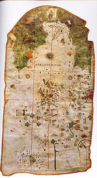
Cartography
Juan de la Cosa made several mapMap
A map is a visual representation of an area—a symbolic depiction highlighting relationships between elements of that space such as objects, regions, and themes....
s of which the only survivor is the famous map of the world, the Mappa Mundi
Mappa mundi
Mappa mundi is a general term used to describe medieval European maps of the world. These maps range in size and complexity from simple schematic maps an inch or less across to elaborate wall maps, the largest of which was 11 ft. in diameter...
of 1500. It is the oldest known European cartographic representation of the New World. Of special interest is the outline of Cuba
Cuba
The Republic of Cuba is an island nation in the Caribbean. The nation of Cuba consists of the main island of Cuba, the Isla de la Juventud, and several archipelagos. Havana is the largest city in Cuba and the country's capital. Santiago de Cuba is the second largest city...
, which Christopher Columbus never believed to be an island. Walkenaer and Alexander von Humboldt
Alexander von Humboldt
Friedrich Wilhelm Heinrich Alexander Freiherr von Humboldt was a German naturalist and explorer, and the younger brother of the Prussian minister, philosopher and linguist Wilhelm von Humboldt...
were the first to point out the great importance of this chart. It is now in the Museo Naval in Madrid
Madrid
Madrid is the capital and largest city of Spain. The population of the city is roughly 3.3 million and the entire population of the Madrid metropolitan area is calculated to be 6.271 million. It is the third largest city in the European Union, after London and Berlin, and its metropolitan...
. Reproductions of it were first given by Humboldt in his Atlas géographique et physique.
See also
- MapMapA map is a visual representation of an area—a symbolic depiction highlighting relationships between elements of that space such as objects, regions, and themes....
- CartographyCartographyCartography is the study and practice of making maps. Combining science, aesthetics, and technique, cartography builds on the premise that reality can be modeled in ways that communicate spatial information effectively.The fundamental problems of traditional cartography are to:*Set the map's...
- List of explorers
- List of cartographers
- List of conquistadors
- Voyages of Christopher ColumbusVoyages of Christopher ColumbusIn the early modern period, the voyages of Columbus initiated European exploration and colonization of the American continents, and are thus of great significance in world history. Christopher Columbus was a navigator and an admiral for Castile, a country that later founded modern Spain...
- The Pinzon BrothersThe Pinzon BrothersThe Pinzón brothers were Spanish sailors, explorers and fishermen, natives of Palos de la Frontera, Huelva, Spain. All three, Martín Alonso, Francisco Martín and Vicente Yañez, participated in Christopher Columbus's first expedition to the New World and in other voyages of discovery and...
- Columbian ExchangeColumbian ExchangeThe Columbian Exchange was a dramatically widespread exchange of animals, plants, culture, human populations , communicable disease, and ideas between the Eastern and Western hemispheres . It was one of the most significant events concerning ecology, agriculture, and culture in all of human history...
or The Grand Exchange