

Numbered highways in the United States
Encyclopedia
Highway
s in the United States
are split into at least four different types of systems.
Highways are generally organized by a route number or letter. These designations are generally displayed along the route by means of a highway shield
. Each system has its own unique shield design that will allow quick identification to which system the route belongs. Below is a list of the different highway shields used throughout the U.S.
 Interstate Highway
Shown: Interstate 95
 Interstate Highway, 3-digit variant
Shown: Interstate 695
.svg.png) Interstate Highway, state-name variant
Interstate Highway, state-name variant
Shown: Interstate 80 in California
.svg.png) Hawaii
Hawaii
Interstate Highway
Shown: Interstate H-1
.svg.png) Hawaii
Hawaii
Interstate Highway, thin font variant
Shown: Interstate H-201
 Business Loop Highway
Shown: Interstate 96 Business (Lansing, Michigan)
 Business Spur Highway
Shown: Interstate 75 Business (Sault Ste. Marie, Michigan)
 United States Numbered Highways
Shown: U.S. Route 20
.svg.png) United States Numbered Highways
United States Numbered Highways
, California
variant
Shown: U.S. Route 6 in California
United States Numbered Highways
, Old Style variant
Shown: U.S. Route 66
in Arizona
 Suffixed United States Numbered Highways
Shown: U.S. Route 25E
.svg.png) Historic United States Numbered Highways
Historic United States Numbered Highways
Shown: Historic U.S. Route 66
.svg.png) Historic United States Numbered Highways
Historic United States Numbered Highways
, California
variant
Shown: Historic U.S. Route 99
in California

 Business Route
Shown: U.S. Route 1 Business

 Bypass Route
Shown: U.S. Route 60 Bypass
 Business Route
, Arkansas
variant
Shown: U.S. Route 71 Business in Arkansas
.svg.png) Business Route
Business Route
, Maryland
variant
Shown: U.S. Route 1 Business
in Maryland

 Truck Route
Shown: U.S. Route 9 Truck

 Alternate Route
Shown: U.S. Route 40 Alternate
 Scenic Route
Shown: U.S. Route 412 Scenic
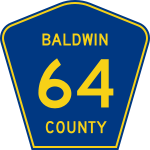 Generic county route
Shown: County Route 64 in Baldwin County, Alabama
 Generic county route (Alternate shield)
Shown: County Route 7 in St. Louis County, Minnesota
 Generic Forest Highway
Shown: Forest Highway 16
 Generic Indian Route
Shown: Indian Route 18
Generic U.S. Bicycle Route
Shown: U.S. Bicycle Route 76
Generic numbered bicycle route
Shown: Bicycle Route 13
 State Routes in Alabama
Shown: State Route 5
 Alaska Routes
Shown: Alaska Route 1
 State Route in Arizona
Shown: State Route 89
 State Highway in Arkansas
Shown: State Highway 87
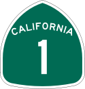 State Route
in California
Shown: State Route 1
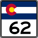 State Highways in Colorado
Shown: State Highway 62
 Routes in Connecticut
Shown: Route 15
 State Routes in Delaware
Shown: State Route 1
 District of Columbia Routes
Shown: District of Columbia Route 295
 State Roads
in Florida
Shown: State Road 60
 State Roads in Florida
, tolled
Shown: State Road 417
 State Route in Georgia
Shown: State Route 5
 Route in Hawaii
Shown: Route 76
 State Highway in Idaho
Shown: State Highway 1
 Illinois Route
Shown: Illinois Route 53
 State Roads in Indiana
Shown: State Road 37
 State Highway in Iowa
*
Shown: Iowa Highway 92
 State Highway in Kansas
*
Shown: K-99
 State Highway in Kentucky
*
Shown: State Highway 1
State Highway in Louisiana
*
Shown: Louisiana Highway 3234
 State Route in Maine
Shown: State Route 9
 Maryland state highway
Shown: Maryland Route 2
 Route in Massachusetts
Shown: Route 24
 State Trunkline in Michigan
Shown: M-28
 Highway in Minnesota
Shown: Highway 55
Highway in Mississippi
Shown: Mississippi Highway 1
 Route in Missouri
Shown: Route 43
 Route in Missouri
, supplemental variant
Shown: Route M
 Highway in Montana
Shown: Montana Highway 80
 Secondary Highway in Montana
Shown: Montana Secondary Highway 326
 State Highway in Nebraska
Shown: Nebraska Highway 2
 State Route in Nevada
Shown: State Route 28
 New Hampshire Route
Shown: New Hampshire Route 16
 Route in New Jersey
Shown: Route 33
 State Highway in New Mexico
*
Shown: New Mexico State Road 14
 Route in New York
Shown: New York State Route 7
 Parkway
in New York City
and Upstate New York
Shown: Bronx River Parkway
 Parkway
on Long Island
, New York
Shown: Meadowbrook Parkway
 State Highway in North Carolina
Shown: North Carolina Highway 3
 State Highways in North Dakota
*
Shown: State Highway 23
 State Route in Ohio
Shown: State Route 2
 State Highway in Oklahoma
, new shield
Shown: State Highway 1
State Highway in Oklahoma
, old shield
Shown: State Highway 1
 Route in Oregon
Shown: Oregon Route 3
 Pennsylvania State Traffic Route
Shown: Pennsylvania Route 10
 Quadrant Route in Pennsylvania
Shown: State Route 3032 (Dauphin County)
 Pennsylvania Turnpike System
 Tolled State Routes
in Pennsylvania
Shown: PA Turnpike 66
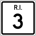 Route in Rhode Island
Shown: Route 3
 State Highway in South Carolina
, new shield
Shown: South Carolina Highway 6
 State Highway in South Carolina
, old shield
Shown: South Carolina Highway 64
 State Highway in South Dakota
Shown: South Dakota Highway 10
 State Route in Tennessee
Shown: State Route 14
 Secondary State Route in Tennessee
Shown: Secondary State Route 14
 State Highway in Texas
Shown: State Highway 6
 State Highway in Texas, tolled
Shown: State Highway 121
 State Highway Loop in Texas
Shown: Loop 1
 State Highway Spur in Texas
Shown: Spur 366
 State Beltway in Texas
Shown: Texas Beltway 8
 Farm to Market Road in Texas
Shown: Farm to Market Road 1960
 Ranch to Market Road in Texas
Shown: Ranch to Market Road 2243
 Park Road in Texas
Shown: Park Road 5
 Recreational Road in Texas
Shown: Recreational Road 2
 State NASA Road in Texas
Shown: NASA Road 1
 Old San Antonio Road in Texas
Shown: Texas OSR the first road in Texas
 State Route in Utah
Shown: State Route 12
 Vermont Route
Shown: Vermont Route 15
 Vermont Route, "state numbered town highway" variant
Shown: Locally maintained Vermont Route 35
 Virginia State Route
Shown: State Route 7
Virginia State Highway, secondary or frontage state highway
Shown: State Route 7100
 State Route
in Washington
Shown: State Route 9
 Primary State Highways in Washington
Shown: PSH 1
Secondary State Highways in Washington
Shown: SSH 1U
 West Virginia Route
*
Shown: West Virginia Route 46
 West Virginia County Route
Shown: County Route 5
 Wisconsin State Trunk Highway
Shown: State Trunk Highway 32
 Wisconsin County Trunk Highway
Shown: County Trunk Highway Z
 State Highway
in Wyoming
*
Shown: Wyoming Highway 24
Highway*
Shown: Territorial Route 001
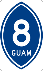 Guam Highways*
Shown: Guam Highway 8
Puerto Rico Highway
Shown: Puerto Rico Highway 1
Puerto Rico Highway, Urban primary variant
Shown: Puerto Rico Highway 1
Puerto Rico Highway, Secondary variant
Shown: Puerto Rico Highway 139
Puerto Rico Highway, Tertiary variant
Shown: Puerto Rico Highway 3
 U.S. Virgin Islands Highway*
Shown: U.S. Virgin Islands Highway 10
became the first state to number its highways. In 1926 the American Association of State Highway Officials (AASHO) established and numbered interstate routes (U.S. route numbers
), selecting the best roads in each state that could be connected to provide a rational network of "federal" highways.
Highway
A highway is any public road. In American English, the term is common and almost always designates major roads. In British English, the term designates any road open to the public. Any interconnected set of highways can be variously referred to as a "highway system", a "highway network", or a...
s in the United States
United States
The United States of America is a federal constitutional republic comprising fifty states and a federal district...
are split into at least four different types of systems.
- Interstate Highways
- The Interstate Highway SystemInterstate Highway SystemThe Dwight D. Eisenhower National System of Interstate and Defense Highways, , is a network of limited-access roads including freeways, highways, and expressways forming part of the National Highway System of the United States of America...
is a federally funded and administered (but state-maintained) system of freeways that forms the transportation backbone of the U.S., with millions of Americans relying on it for commutes and freight transport daily. Interstate highways are all constructed to precise standardsInterstate Highway standardsStandards for Interstate Highways in the United States are defined by the American Association of State Highway and Transportation Officials in the publication A Policy on Design Standards - Interstate System...
, designed to maximize high-speed travel safety and efficiency. Interstate Highways also contain auxiliary routes, which are normally assigned a three-digit route number. All Interstate Highways are part of the National Highway SystemNational Highway System (United States)The National Highway System is a network of strategic highways within the United States, including the Interstate Highway System and other roads serving major airports, ports, rail or truck terminals, railway stations, pipeline terminals and other strategic transport facilities.Individual states...
, a network of highways deemed essential to the defense, economy, and mobility of the country.
- The Interstate Highway System
- U.S. Highways
- The U.S. Highway System (officially "United States Numbered HighwaysUnited States Numbered HighwaysThe system of United States Numbered Highways is an integrated system of roads and highways in the United States numbered within a nationwide grid...
") is an older system consisting mostly of surface-level trunk roads, coordinated by the American Association of State Highway and Transportation OfficialsAmerican Association of State Highway and Transportation OfficialsAASHTO, the American Association of State Highway and Transportation Officials, is a standards setting body which publishes specifications, test protocols and guidelines which are used in highway design and construction throughout the United States...
and maintained by state and local governments. U.S. highways have been relegated to regional and intrastate traffic, as they have been largely supplanted by the Interstate system for long-distance travel except in areas (especially in the west) where the Interstate system is absent or underdeveloped. This has led to the decommissioning and truncation of U.S. Highways that were formerly vital long-haul routes, such as U.S. Route 21U.S. Route 21U.S. Route 21 is a north–south United States highway of , from Hunting Island State Park, South Carolina to Wytheville, Virginia.-South Carolina:...
and U.S. Route 66U.S. Route 66U.S. Route 66 was a highway within the U.S. Highway System. One of the original U.S. highways, Route 66 was established on November 11, 1926 -- with road signs erected the following year...
.
- The U.S. Highway System (officially "United States Numbered Highways
- State Highways
- Each stateU.S. stateA U.S. state is any one of the 50 federated states of the United States of America that share sovereignty with the federal government. Because of this shared sovereignty, an American is a citizen both of the federal entity and of his or her state of domicile. Four states use the official title of...
also has a state highwayState highwayState highway, state road or state route can refer to one of three related concepts, two of them related to a state or provincial government in a country that is divided into states or provinces :#A...
system. State highways are of varying standards and quality. Some state highways become so heavily traveled they are built to Interstate Highway standards. Others are so lightly traveled that they are roads of low quality.
- Each state
- County Highways
- The final administrative level in some states is the county-maintained county highwayCounty highwayA county highway is a road in the United States and in the Canadian province of Ontario that is designated and/or maintained by the county highway department...
. (The term "parish" is used instead in LouisianaLouisianaLouisiana is a state located in the southern region of the United States of America. Its capital is Baton Rouge and largest city is New Orleans. Louisiana is the only state in the U.S. with political subdivisions termed parishes, which are local governments equivalent to counties...
.) County routes vary widely from well-traveled multilane highways to dirt roads into remote parts of the county.
- The final administrative level in some states is the county-maintained county highway
Highways are generally organized by a route number or letter. These designations are generally displayed along the route by means of a highway shield
Highway shield
A highway shield is a sign denoting the route number of a highway, usually in the form of a symbolic shape with the route number enclosed. As the focus of the sign, the route number is usually the sign's largest element, with other items on the sign rendered in smaller sizes or contrasting colours...
. Each system has its own unique shield design that will allow quick identification to which system the route belongs. Below is a list of the different highway shields used throughout the U.S.
Interstate Highways
Shown: Interstate 95
Interstate 95
Interstate 95 is the main highway on the East Coast of the United States, running parallel to the Atlantic Ocean from Maine to Florida and serving some of the most populated urban areas in the country, including Boston, Providence, New Haven, New York City, Newark, Philadelphia, Baltimore,...
Shown: Interstate 695
Shown: Interstate 80 in California
Interstate 80 in California
In the U.S. state of California, Interstate 80 , a major east–west route of the Interstate Highway System, has its western terminus in San Francisco, California, United States. From there it heads east across the Bay Bridge to Oakland, where it turns north and crosses the Carquinez Bridge...
Hawaii
Hawaii is the newest of the 50 U.S. states , and is the only U.S. state made up entirely of islands. It is the northernmost island group in Polynesia, occupying most of an archipelago in the central Pacific Ocean, southwest of the continental United States, southeast of Japan, and northeast of...
Interstate Highway
Shown: Interstate H-1
Interstate H-1
Interstate H-1 is the busiest Interstate Highway in Hawaii, United States, located on the island of O‘ahu. Despite the number, this is an east–west highway—the 'H'-series numbering reflects the order in which routes were funded and built. H-1 goes from Route 93 in Kapolei to Route 72 in...
Hawaii
Hawaii is the newest of the 50 U.S. states , and is the only U.S. state made up entirely of islands. It is the northernmost island group in Polynesia, occupying most of an archipelago in the central Pacific Ocean, southwest of the continental United States, southeast of Japan, and northeast of...
Interstate Highway, thin font variant
Shown: Interstate H-201
Interstate H-201
Interstate H-201 is an auxiliary Interstate Highway located on the island of O‘ahu in the U.S. state of Hawaii. The H-201 is also known as the Moanalua Freeway...
Shown: Interstate 96 Business (Lansing, Michigan)
Shown: Interstate 75 Business (Sault Ste. Marie, Michigan)
U.S. Numbered Highways
United States Numbered Highways
The system of United States Numbered Highways is an integrated system of roads and highways in the United States numbered within a nationwide grid...
Shown: U.S. Route 20
U.S. Route 20
U.S. Route 20 is an east–west United States highway. As the "0" in its route number implies, US 20 is a coast-to-coast route. Spanning , it is the longest road in the United States, and the route sparsely parallels Interstate 90...
United States Numbered Highways
The system of United States Numbered Highways is an integrated system of roads and highways in the United States numbered within a nationwide grid...
, California
California
California is a state located on the West Coast of the United States. It is by far the most populous U.S. state, and the third-largest by land area...
variant
Shown: U.S. Route 6 in California
U.S. Route 6 in California
U.S. Route 6, or US 6, is a transcontinental highway from the U.S. state of California to Massachusetts. In California, the highway lies in the eastern portion of the state from Bishop in the Owens Valley north to the Nevada state line in Esmeralda County...
United States Numbered Highways
United States Numbered Highways
The system of United States Numbered Highways is an integrated system of roads and highways in the United States numbered within a nationwide grid...
, Old Style variant
Shown: U.S. Route 66
U.S. Route 66
U.S. Route 66 was a highway within the U.S. Highway System. One of the original U.S. highways, Route 66 was established on November 11, 1926 -- with road signs erected the following year...
in Arizona
Arizona
Arizona ; is a state located in the southwestern region of the United States. It is also part of the western United States and the mountain west. The capital and largest city is Phoenix...
United States Numbered Highways
The system of United States Numbered Highways is an integrated system of roads and highways in the United States numbered within a nationwide grid...
Shown: U.S. Route 25E
U.S. Route 25E
U.S. Route 25E is the eastern branch of U.S. Route 25 from Newport, Tennessee, where US 25 splits into US 25E and US 25W, to North Corbin, Kentucky, where the two highways rejoin...
United States Numbered Highways
The system of United States Numbered Highways is an integrated system of roads and highways in the United States numbered within a nationwide grid...
Shown: Historic U.S. Route 66
U.S. Route 66
U.S. Route 66 was a highway within the U.S. Highway System. One of the original U.S. highways, Route 66 was established on November 11, 1926 -- with road signs erected the following year...
United States Numbered Highways
The system of United States Numbered Highways is an integrated system of roads and highways in the United States numbered within a nationwide grid...
, California
California
California is a state located on the West Coast of the United States. It is by far the most populous U.S. state, and the third-largest by land area...
variant
Shown: Historic U.S. Route 99
U.S. Route 99
U.S. Route 99 was the main north–south highway on the West Coast of the United States until 1964, running from Calexico, California, on the U.S.-Mexico border to Blaine, Washington, on the U.S.-Canada border. It was a route of the United States Numbered Highways, assigned in 1926 and existing...
in California
California
California is a state located on the West Coast of the United States. It is by far the most populous U.S. state, and the third-largest by land area...
Business route
A business route in the United States and Canada is a short special route connected to a parent numbered highway at its beginning, then routed through the central business district of a nearby city or town, and finally reconnecting with the same parent numbered highway again at its...
Shown: U.S. Route 1 Business
Bannered routes of U.S. Route 1
Several bannered routes of U.S. Route 1 exist, from Florida to Maine. In order from south to north, separated by type, they are as follows.-Jacksonville alternate route:...
Bypass (road)
A bypass is a road or highway that avoids or "bypasses" a built-up area, town, or village, to let through traffic flow without interference from local traffic, to reduce congestion in the built-up area, and to improve road safety....
Shown: U.S. Route 60 Bypass
Bannered routes of U.S. Route 60
Business US 60 in Ponca City begins at an interchange with US 60 and US 177 and continues east down South Street. It turns north onto Pine Street, heading into the downtown area, east on Central, and north on Union Street. It turns east again onto Grand Avenue. At 14th Street, it turns south,...
Business route
A business route in the United States and Canada is a short special route connected to a parent numbered highway at its beginning, then routed through the central business district of a nearby city or town, and finally reconnecting with the same parent numbered highway again at its...
, Arkansas
Arkansas
Arkansas is a state located in the southern region of the United States. Its name is an Algonquian name of the Quapaw Indians. Arkansas shares borders with six states , and its eastern border is largely defined by the Mississippi River...
variant
Shown: U.S. Route 71 Business in Arkansas
Arkansas
Arkansas is a state located in the southern region of the United States. Its name is an Algonquian name of the Quapaw Indians. Arkansas shares borders with six states , and its eastern border is largely defined by the Mississippi River...
Business route
A business route in the United States and Canada is a short special route connected to a parent numbered highway at its beginning, then routed through the central business district of a nearby city or town, and finally reconnecting with the same parent numbered highway again at its...
, Maryland
Maryland
Maryland is a U.S. state located in the Mid Atlantic region of the United States, bordering Virginia, West Virginia, and the District of Columbia to its south and west; Pennsylvania to its north; and Delaware to its east...
variant
Shown: U.S. Route 1 Business
Bannered routes of U.S. Route 1
Several bannered routes of U.S. Route 1 exist, from Florida to Maine. In order from south to north, separated by type, they are as follows.-Jacksonville alternate route:...
in Maryland
Maryland
Maryland is a U.S. state located in the Mid Atlantic region of the United States, bordering Virginia, West Virginia, and the District of Columbia to its south and west; Pennsylvania to its north; and Delaware to its east...
Shown: U.S. Route 9 Truck
Alternate route
An official alternate route is a special route in the United States that provides an alternate alignment for a highway. They are loop roads and found in many road systems in the United States including the U.S. Route system and various state route systems...
Shown: U.S. Route 40 Alternate
U.S. Route 40 Alternate
U.S. Route 40 Alternate may refer to:*U.S. Route 40 Alternate *U.S. Route 40 Alternate *California State Highway 70, formerly U.S. Route 40 Alternate...
Scenic route
A scenic route, tourist road, tourist route, theme route, or scenic byway is a specially designated road or waterway that travels through an area of natural or cultural beauty...
Shown: U.S. Route 412 Scenic
Generic routes
Shown: County Route 64 in Baldwin County, Alabama
Baldwin County, Alabama
-2010:Whereas according to the 2010 U.S. Census Bureau:*85.7% White*9.4% Black*0.7% Native American*0.7% Asian*0.0% Native Hawaiian or Pacific Islander*1.5% Two or more races*4.4% Hispanic or Latino -2000:...
Shown: County Route 7 in St. Louis County, Minnesota
St. Louis County, Minnesota
St. Louis County is a county located in the U.S. state of Minnesota. As of 2010, the population was 200,226. Its county seat is Duluth. It is the largest county by total area in Minnesota, and the second largest in the United States east of the Mississippi River; in land area alone, after Aroostook...
Forest Highway
Forest Highways or Forest Routes are a category of roads within United States National Forests. They are built to connect the national forests to the existing state highway systems, and to provide improved access to recreational and logging areas....
Shown: Forest Highway 16
Forest Highway 16
Federal Forest Highway 16 is a forest highway in the western Upper Peninsula of Michigan, United States. This road is erroneously marked as H-16 on the Michigan Department of Transportation map. It runs through the Ottawa National Forest and is designated by the National Forest Service...
Indian route (United States)
An Indian route is a type of minor numbered road in the United States found on some Indian reservations. The routes are signed by shields featuring a downward-pointing arrowhead with varying designs depending on the state and/or reservation....
Shown: Indian Route 18
Generic U.S. Bicycle Route
United States Numbered Bicycle Routes
United States numbered bicycle routes are regional bicycle routes in the United States. They are the bicycle equivalent to the system of United States numbered highways. The system consisted of only two routes from its inception in 1982, until its first major expansion in 2011. Currently seven...
Shown: U.S. Bicycle Route 76
U.S. Bicycle Route 76
U.S. Bicycle Route 76 is a cross-country bicycle route east of the Mississippi River in the United States. It is one of the two original U.S. Bicycle Routes, the other being U.S. Bicycle Route 1. U.S. Bicycle Route 76 runs from the midwestern state of Illinois to the eastern seaboard state of...
Generic numbered bicycle route
Shown: Bicycle Route 13
State highways and other similar systems
Many state highway markers are designed to suggest the geographic shape of the state or some other state symbol such as its flag. Most of the others are generically rectangular or some other neutral shape. The default design for state highway markers is the circular highway shield.Alabama
Alabama is a state located in the southeastern region of the United States. It is bordered by Tennessee to the north, Georgia to the east, Florida and the Gulf of Mexico to the south, and Mississippi to the west. Alabama ranks 30th in total land area and ranks second in the size of its inland...
Shown: State Route 5
Shown: Alaska Route 1
Alaska Route 1
Alaska Route 1 is a state highway in the southern portion of the U.S. state of Alaska. It runs from Homer northeast and east to Tok by way of Anchorage...
Arizona
Arizona ; is a state located in the southwestern region of the United States. It is also part of the western United States and the mountain west. The capital and largest city is Phoenix...
Shown: State Route 89
Arkansas
Arkansas is a state located in the southern region of the United States. Its name is an Algonquian name of the Quapaw Indians. Arkansas shares borders with six states , and its eastern border is largely defined by the Mississippi River...
Shown: State Highway 87
State highways in California
Each state highway in the U.S. State of California is maintained by the California Department of Transportation and is assigned a Route number in the Streets and Highways Code . Most of these are numbered in a statewide system, and are known as State Route X...
in California
California
California is a state located on the West Coast of the United States. It is by far the most populous U.S. state, and the third-largest by land area...
Shown: State Route 1
California State Route 1
State Route 1 , more often called Highway 1, is a state highway that runs along much of the Pacific coast of the U.S. state of California. It is famous for running along some of the most beautiful coastlines in the world, leading to its designation as an All-American Road.Highway 1 does not run...
Colorado
Colorado is a U.S. state that encompasses much of the Rocky Mountains as well as the northeastern portion of the Colorado Plateau and the western edge of the Great Plains...
Shown: State Highway 62
Colorado State Highway 62
State Highway 62 is a 23.41 mile long state highway in the U.S. state of Colorado.-Route description:SH 62 starts at a junction with just north of Ridgeway in the San Miguel River valley and heads northeast up the Leopard Creek Canyon. The highway bends slowly to the east before crossing the...
Connecticut
Connecticut is a state in the New England region of the northeastern United States. It is bordered by Rhode Island to the east, Massachusetts to the north, and the state of New York to the west and the south .Connecticut is named for the Connecticut River, the major U.S. river that approximately...
Shown: Route 15
Delaware
Delaware is a U.S. state located on the Atlantic Coast in the Mid-Atlantic region of the United States. It is bordered to the south and west by Maryland, and to the north by Pennsylvania...
Shown: State Route 1
Shown: District of Columbia Route 295
District of Columbia Route 295
District of Columbia Route 295 , also known as the Anacostia Freeway south of East Capitol Street or Kenilworth Avenue north of East Capitol Street, is a freeway in the District of Columbia, and currently the only numbered route in the District that is not an Interstate Highway or U.S. Highway...
State Roads in Florida
Roads maintained by the Florida Department of Transportation or a toll authority are referred to officially as State Roads, abbreviated SR. State Roads are always numbered; in general, the numbers follow a grid. Odd numbered roads run north-south, and even numbered roads run east-west...
in Florida
Florida
Florida is a state in the southeastern United States, located on the nation's Atlantic and Gulf coasts. It is bordered to the west by the Gulf of Mexico, to the north by Alabama and Georgia and to the east by the Atlantic Ocean. With a population of 18,801,310 as measured by the 2010 census, it...
Shown: State Road 60
State Road 60 (Florida)
State Road 60 is an east–west route transversing Florida from the Gulf of Mexico to the Atlantic Ocean. The western terminus of SR 60 is at the Sunsets at Pier 60 in Clearwater...
State Roads in Florida
Roads maintained by the Florida Department of Transportation or a toll authority are referred to officially as State Roads, abbreviated SR. State Roads are always numbered; in general, the numbers follow a grid. Odd numbered roads run north-south, and even numbered roads run east-west...
, tolled
Shown: State Road 417
Georgia (U.S. state)
Georgia is a state located in the southeastern United States. It was established in 1732, the last of the original Thirteen Colonies. The state is named after King George II of Great Britain. Georgia was the fourth state to ratify the United States Constitution, on January 2, 1788...
Shown: State Route 5
Hawaii
Hawaii is the newest of the 50 U.S. states , and is the only U.S. state made up entirely of islands. It is the northernmost island group in Polynesia, occupying most of an archipelago in the central Pacific Ocean, southwest of the continental United States, southeast of Japan, and northeast of...
Shown: Route 76
Hawaii Route 76
Route 76 or Fort Weaver Road is a major north-south highway on the island of Oahu which begins at Interstate H-1 in Waipahu and ends in Ewa Beach.-Route description:Route 76 is the main thoroughfare from the Ewa Beach Community to Interstate H-1...
Idaho
Idaho is a state in the Rocky Mountain area of the United States. The state's largest city and capital is Boise. Residents are called "Idahoans". Idaho was admitted to the Union on July 3, 1890, as the 43rd state....
Shown: State Highway 1
Idaho State Highway 1
State Highway 1 is a state highway in Boundary County, in the U.S. state of Idaho. It extends from U.S. Route 95 east of Copeland, north to British Columbia Highway 21 in Porthill. The route serves as a connector between Bonners Ferry, via US-95 south, Porthill, and Creston, BC. The highway is...
Shown: Illinois Route 53
Illinois Route 53
Illinois Route 53 is an arterial north–south state highway in northeast Illinois. Route 53 runs south from Long Grove at Illinois Route 83 to Gardner at Interstate 55 west of old U.S. Highway 66, a distance of...
Indiana
Indiana is a US state, admitted to the United States as the 19th on December 11, 1816. It is located in the Midwestern United States and Great Lakes Region. With 6,483,802 residents, the state is ranked 15th in population and 16th in population density. Indiana is ranked 38th in land area and is...
Shown: State Road 37
Iowa
Iowa is a state located in the Midwestern United States, an area often referred to as the "American Heartland". It derives its name from the Ioway people, one of the many American Indian tribes that occupied the state at the time of European exploration. Iowa was a part of the French colony of New...
*
Shown: Iowa Highway 92
Kansas
Kansas is a US state located in the Midwestern United States. It is named after the Kansas River which flows through it, which in turn was named after the Kansa Native American tribe, which inhabited the area. The tribe's name is often said to mean "people of the wind" or "people of the south...
*
Shown: K-99
K-99 (Kansas highway)
K-99 is a Kansas state highway that runs north–south through the eastern part of the state.K-99 has its northern terminus near Summerfield at the Nebraska state line and its southern end south of Chautauqua where it crosses the Oklahoma border and becomes State Highway 99...
Kentucky
The Commonwealth of Kentucky is a state located in the East Central United States of America. As classified by the United States Census Bureau, Kentucky is a Southern state, more specifically in the East South Central region. Kentucky is one of four U.S. states constituted as a commonwealth...
*
Shown: State Highway 1
State Highway in Louisiana
Louisiana
Louisiana is a state located in the southern region of the United States of America. Its capital is Baton Rouge and largest city is New Orleans. Louisiana is the only state in the U.S. with political subdivisions termed parishes, which are local governments equivalent to counties...
*
Shown: Louisiana Highway 3234
Louisiana Highway 3234
Louisiana Highway 3234 , also known as University Avenue, is a multilane state highway in Hammond, Louisiana. LA 3234 runs from west to east for and is the artery for Southeastern Louisiana University's main entrance...
Maine
Maine is a state in the New England region of the northeastern United States, bordered by the Atlantic Ocean to the east and south, New Hampshire to the west, and the Canadian provinces of Quebec to the northwest and New Brunswick to the northeast. Maine is both the northernmost and easternmost...
Shown: State Route 9
Maryland highway system
The Maryland highway system is a network of highways owned and maintained by the U.S. state of Maryland. In addition to the nationally-numbered Interstate Highways and U.S. Highways, the highway system consists of a network of Maryland state-numbered highways...
Shown: Maryland Route 2
Maryland Route 2
Maryland Route 2 is the longest state highway in the U.S. state of Maryland. The route runs from Solomons Island in Calvert County north to an intersection with U.S. Route 1 and U.S. Route 40 Truck in Baltimore...
Massachusetts
The Commonwealth of Massachusetts is a state in the New England region of the northeastern United States of America. It is bordered by Rhode Island and Connecticut to the south, New York to the west, and Vermont and New Hampshire to the north; at its east lies the Atlantic Ocean. As of the 2010...
Shown: Route 24
Route 24 (Massachusetts)
Route 24 is a freeway south of I-93 in southeastern Massachusetts, linking Fall River with the Boston metropolitan area. It begins in the south in Fall River at the border with Tiverton, Rhode Island where it connects with Rhode Island Route 24, and runs north to an interchange with Interstate...
Michigan
Michigan is a U.S. state located in the Great Lakes Region of the United States of America. The name Michigan is the French form of the Ojibwa word mishigamaa, meaning "large water" or "large lake"....
Shown: M-28
M-28 (Michigan highway)
M-28 is an east–west state trunkline highway that almost completely traverses the Upper Peninsula in the U.S. state of Michigan, from Wakefield to near Sault Ste. Marie in Bruce Township...
Minnesota
Minnesota is a U.S. state located in the Midwestern United States. The twelfth largest state of the U.S., it is the twenty-first most populous, with 5.3 million residents. Minnesota was carved out of the eastern half of the Minnesota Territory and admitted to the Union as the thirty-second state...
Shown: Highway 55
Minnesota State Highway 55
Minnesota State Highway 55 is a highway in west-central, central, and east-central Minnesota, which runs from the North Dakota state line near Tenney and continues east and southeast to its eastern terminus at its intersection with U.S...
Mississippi
Mississippi is a U.S. state located in the Southern United States. Jackson is the state capital and largest city. The name of the state derives from the Mississippi River, which flows along its western boundary, whose name comes from the Ojibwe word misi-ziibi...
Shown: Mississippi Highway 1
Missouri
Missouri is a US state located in the Midwestern United States, bordered by Iowa, Illinois, Kentucky, Tennessee, Arkansas, Oklahoma, Kansas and Nebraska. With a 2010 population of 5,988,927, Missouri is the 18th most populous state in the nation and the fifth most populous in the Midwest. It...
Shown: Route 43
Missouri
Missouri is a US state located in the Midwestern United States, bordered by Iowa, Illinois, Kentucky, Tennessee, Arkansas, Oklahoma, Kansas and Nebraska. With a 2010 population of 5,988,927, Missouri is the 18th most populous state in the nation and the fifth most populous in the Midwest. It...
, supplemental variant
Shown: Route M
Montana
Montana is a state in the Western United States. The western third of Montana contains numerous mountain ranges. Smaller, "island ranges" are found in the central third of the state, for a total of 77 named ranges of the Rocky Mountains. This geographical fact is reflected in the state's name,...
Shown: Montana Highway 80
Montana Highway 80
Highway 80 in the U.S. State of Montana is a route running in a northerly direction from an intersection with U.S. Route 87 at the community of Stanford. The highway extends approximately to a northern terminus at the town of Fort Benton. The landscape is hilly and rural, and largely used for...
Montana
Montana is a state in the Western United States. The western third of Montana contains numerous mountain ranges. Smaller, "island ranges" are found in the central third of the state, for a total of 77 named ranges of the Rocky Mountains. This geographical fact is reflected in the state's name,...
Shown: Montana Secondary Highway 326
Montana Secondary Highway 326
Montana Secondary Highway 326 is a secondary state highway in the extreme south part of Carter County, Montana.- Route description :...
Nebraska
Nebraska is a state on the Great Plains of the Midwestern United States. The state's capital is Lincoln and its largest city is Omaha, on the Missouri River....
Shown: Nebraska Highway 2
Nebraska Highway 2
Nebraska Highway 2 is a highway in Nebraska. It is a discontinuous highway with 2 segments. The western segment begins at the South Dakota border northwest of Crawford and ends southeast of Grand Island at an intersection with Interstate 80. The eastern segment begins in Lincoln and ends at the...
Nevada
Nevada is a state in the western, mountain west, and southwestern regions of the United States. With an area of and a population of about 2.7 million, it is the 7th-largest and 35th-most populous state. Over two-thirds of Nevada's people live in the Las Vegas metropolitan area, which contains its...
Shown: State Route 28
Nevada State Route 28
State Route 28 is a road that runs along the northeastern shore of Lake Tahoe. The road has been designated as the north piece of the Lake Tahoe–Eastshore Drive Scenic Byway as part of the National Scenic Byway program...
Shown: New Hampshire Route 16
New Hampshire Route 16
New Hampshire Route 16 is a long north–south highway in the U.S. state of New Hampshire. Much of its length is close to the border with Maine. NH 16 is the main route from the Seacoast region north to the Lakes Region and the White Mountains. The section from Portsmouth to Milton is a...
New Jersey
New Jersey is a state in the Northeastern and Middle Atlantic regions of the United States. , its population was 8,791,894. It is bordered on the north and east by the state of New York, on the southeast and south by the Atlantic Ocean, on the west by Pennsylvania and on the southwest by Delaware...
Shown: Route 33
Route 33 (New Jersey)
Route 33 is a state highway in the U.S. state of New Jersey. The highway extends , from Trenton at an intersection with U.S. Route 1 and Route 129 to an intersection with Route 71 in Neptune Township. The speed limit on Route 33 differs in zones. The highest is 55 mph in Zone 9...
New Mexico
New Mexico is a state located in the southwest and western regions of the United States. New Mexico is also usually considered one of the Mountain States. With a population density of 16 per square mile, New Mexico is the sixth-most sparsely inhabited U.S...
*
Shown: New Mexico State Road 14
New York
New York is a state in the Northeastern region of the United States. It is the nation's third most populous state. New York is bordered by New Jersey and Pennsylvania to the south, and by Connecticut, Massachusetts and Vermont to the east...
Shown: New York State Route 7
New York State Route 7
New York State Route 7 is a 180-mile long New York State Highway that runs from the New York/Pennsylvania border south of Binghamton, New York to the New York/Vermont border east of Hoosick. Most of the road runs along the Susquehanna Valley, closely paralleling Interstate 88 throughout...
New York State Parkway System
The New York State Parkway System opened its first section in 1908 and was a series of then-high speed four-lane roads that were created to provide a scenic way into, out of, and around New York City. The parkway system is still in use today...
in New York City
New York City
New York is the most populous city in the United States and the center of the New York Metropolitan Area, one of the most populous metropolitan areas in the world. New York exerts a significant impact upon global commerce, finance, media, art, fashion, research, technology, education, and...
and Upstate New York
Upstate New York
Upstate New York is the region of the U.S. state of New York that is located north of the core of the New York metropolitan area.-Definition:There is no clear or official boundary between Upstate New York and Downstate New York...
Shown: Bronx River Parkway
Bronx River Parkway
The Bronx River Parkway is a long parkway in downstate New York. It is named for the nearby Bronx River, which it parallels. The southern terminus of the parkway is at Story Avenue near Bruckner Expressway in the Bronx neighborhood of Soundview...
New York State Parkway System
The New York State Parkway System opened its first section in 1908 and was a series of then-high speed four-lane roads that were created to provide a scenic way into, out of, and around New York City. The parkway system is still in use today...
on Long Island
Long Island
Long Island is an island located in the southeast part of the U.S. state of New York, just east of Manhattan. Stretching northeast into the Atlantic Ocean, Long Island contains four counties, two of which are boroughs of New York City , and two of which are mainly suburban...
, New York
New York
New York is a state in the Northeastern region of the United States. It is the nation's third most populous state. New York is bordered by New Jersey and Pennsylvania to the south, and by Connecticut, Massachusetts and Vermont to the east...
Shown: Meadowbrook Parkway
North Carolina
North Carolina is a state located in the southeastern United States. The state borders South Carolina and Georgia to the south, Tennessee to the west and Virginia to the north. North Carolina contains 100 counties. Its capital is Raleigh, and its largest city is Charlotte...
Shown: North Carolina Highway 3
North Dakota
North Dakota is a state located in the Midwestern region of the United States of America, along the Canadian border. The state is bordered by Canada to the north, Minnesota to the east, South Dakota to the south and Montana to the west. North Dakota is the 19th-largest state by area in the U.S....
*
Shown: State Highway 23
Ohio
Ohio is a Midwestern state in the United States. The 34th largest state by area in the U.S.,it is the 7th‑most populous with over 11.5 million residents, containing several major American cities and seven metropolitan areas with populations of 500,000 or more.The state's capital is Columbus...
Shown: State Route 2
Oklahoma
Oklahoma is a state located in the South Central region of the United States of America. With an estimated 3,751,351 residents as of the 2010 census and a land area of 68,667 square miles , Oklahoma is the 28th most populous and 20th-largest state...
, new shield
Shown: State Highway 1
State Highway 1 (Oklahoma)
State Highway 1, sometimes abbreviated as SH-1 or OK-1, is a highway maintained by the U.S. state of Oklahoma. It travels through the southeastern part of the state, nicknamed Little Dixie. Because Oklahoma uses odd numbers for east and west highways State Highway 1, sometimes abbreviated as SH-1...
Oklahoma
Oklahoma is a state located in the South Central region of the United States of America. With an estimated 3,751,351 residents as of the 2010 census and a land area of 68,667 square miles , Oklahoma is the 28th most populous and 20th-largest state...
, old shield
Shown: State Highway 1
State Highway 1 (Oklahoma)
State Highway 1, sometimes abbreviated as SH-1 or OK-1, is a highway maintained by the U.S. state of Oklahoma. It travels through the southeastern part of the state, nicknamed Little Dixie. Because Oklahoma uses odd numbers for east and west highways State Highway 1, sometimes abbreviated as SH-1...
Oregon
Oregon is a state in the Pacific Northwest region of the United States. It is located on the Pacific coast, with Washington to the north, California to the south, Nevada on the southeast and Idaho to the east. The Columbia and Snake rivers delineate much of Oregon's northern and eastern...
Shown: Oregon Route 3
Shown: Pennsylvania Route 10
Pennsylvania Route 10
Pennsylvania Route 10 is a long state route in southeastern Pennsylvania. PA 10 runs parallel to Interstate 176 for less than near Morgantown. Its southern terminus is at Pennsylvania Route 472 in Oxford. Its northern terminus is at U.S...
Pennsylvania
The Commonwealth of Pennsylvania is a U.S. state that is located in the Northeastern and Mid-Atlantic regions of the United States. The state borders Delaware and Maryland to the south, West Virginia to the southwest, Ohio to the west, New York and Ontario, Canada, to the north, and New Jersey to...
Shown: State Route 3032 (Dauphin County)
State Route 3032 (Dauphin County, Pennsylvania)
The Airport Connector is a two mile freeway in the Harrisburg, Pennsylvania, area in the United States. It begins at PA 283 and ends at Harrisburg International Airport. There is one intermediate exit with PA 230...
Pennsylvania Turnpike
The Pennsylvania Turnpike is a toll highway system operated by the Pennsylvania Turnpike Commission in the Commonwealth of Pennsylvania, United States. The three sections of the turnpike system total . The main section extends from Ohio to New Jersey and is long...
Pennsylvania Turnpike Commission
The Pennsylvania Turnpike Commission was created in 1937 to construct, finance, operate and maintain the Pennsylvania Turnpike. The commission consists of five members. Four members are appointed by the Governor of Pennsylvania. The fifth member is the Pennsylvania Secretary of Transportation.In...
in Pennsylvania
Pennsylvania
The Commonwealth of Pennsylvania is a U.S. state that is located in the Northeastern and Mid-Atlantic regions of the United States. The state borders Delaware and Maryland to the south, West Virginia to the southwest, Ohio to the west, New York and Ontario, Canada, to the north, and New Jersey to...
Shown: PA Turnpike 66
Pennsylvania Route 66
Pennsylvania Route 66 is a long state highway in Western Pennsylvania. Its northern terminus is at U.S. Route 6 in Kane. Its southern terminus is at US 119 near New Stanton. West of Greensburg, PA 66 becomes the tolled Amos K. Hutchinson Bypass, a part of the Pennsylvania Turnpike System. The...
Rhode Island
The state of Rhode Island and Providence Plantations, more commonly referred to as Rhode Island , is a state in the New England region of the United States. It is the smallest U.S. state by area...
Shown: Route 3
Route 3 (Rhode Island)
Route 3 is a state highway in the U.S. state of Rhode Island.-Route:Route 3 takes the following route through the State:*Westerly: ; U.S...
South Carolina
South Carolina is a state in the Deep South of the United States that borders Georgia to the south, North Carolina to the north, and the Atlantic Ocean to the east. Originally part of the Province of Carolina, the Province of South Carolina was one of the 13 colonies that declared independence...
, new shield
Shown: South Carolina Highway 6
South Carolina
South Carolina is a state in the Deep South of the United States that borders Georgia to the south, North Carolina to the north, and the Atlantic Ocean to the east. Originally part of the Province of Carolina, the Province of South Carolina was one of the 13 colonies that declared independence...
, old shield
Shown: South Carolina Highway 64
South Dakota
South Dakota is a state located in the Midwestern region of the United States. It is named after the Lakota and Dakota Sioux American Indian tribes. Once a part of Dakota Territory, South Dakota became a state on November 2, 1889. The state has an area of and an estimated population of just over...
Shown: South Dakota Highway 10
Tennessee
Tennessee is a U.S. state located in the Southeastern United States. It has a population of 6,346,105, making it the nation's 17th-largest state by population, and covers , making it the 36th-largest by total land area...
Shown: State Route 14
Tennessee
Tennessee is a U.S. state located in the Southeastern United States. It has a population of 6,346,105, making it the nation's 17th-largest state by population, and covers , making it the 36th-largest by total land area...
Shown: Secondary State Route 14
Texas
Texas is the second largest U.S. state by both area and population, and the largest state by area in the contiguous United States.The name, based on the Caddo word "Tejas" meaning "friends" or "allies", was applied by the Spanish to the Caddo themselves and to the region of their settlement in...
Shown: State Highway 6
Shown: State Highway 121
Texas
Texas is the second largest U.S. state by both area and population, and the largest state by area in the contiguous United States.The name, based on the Caddo word "Tejas" meaning "friends" or "allies", was applied by the Spanish to the Caddo themselves and to the region of their settlement in...
Shown: Loop 1
State Highway Loop 1 (Texas)
Loop 1 is a controlled-access highway which provides access to the west side of Austin in the U.S. state of Texas. It is named Mopac Expressway after the Missouri Pacific Railroad...
Texas
Texas is the second largest U.S. state by both area and population, and the largest state by area in the contiguous United States.The name, based on the Caddo word "Tejas" meaning "friends" or "allies", was applied by the Spanish to the Caddo themselves and to the region of their settlement in...
Shown: Spur 366
State Highway Spur 366 (Texas)
Spur 366, also named Woodall Rodgers Freeway, is a highway that connects Interstate 35E to Interstate 345 in central Dallas, Texas...
Texas
Texas is the second largest U.S. state by both area and population, and the largest state by area in the contiguous United States.The name, based on the Caddo word "Tejas" meaning "friends" or "allies", was applied by the Spanish to the Caddo themselves and to the region of their settlement in...
Shown: Texas Beltway 8
Texas
Texas is the second largest U.S. state by both area and population, and the largest state by area in the contiguous United States.The name, based on the Caddo word "Tejas" meaning "friends" or "allies", was applied by the Spanish to the Caddo themselves and to the region of their settlement in...
Shown: Farm to Market Road 1960
Farm to Market Road 1960
Farm to Market Road 1960 is a state highway in the U.S. state of Texas. Its western terminus is at an intersection with U.S...
Texas
Texas is the second largest U.S. state by both area and population, and the largest state by area in the contiguous United States.The name, based on the Caddo word "Tejas" meaning "friends" or "allies", was applied by the Spanish to the Caddo themselves and to the region of their settlement in...
Shown: Ranch to Market Road 2243
Ranch to Market Road 2243
Ranch to Market Road 2243 is a ranch to market road in Williamson County, Texas.-Route description:RM 2243 begins in Leander, at an intersection with . It travels to the east along South Street, crossing the current 183A Toll Road along its current non-controlled-access northern stub...
Texas
Texas is the second largest U.S. state by both area and population, and the largest state by area in the contiguous United States.The name, based on the Caddo word "Tejas" meaning "friends" or "allies", was applied by the Spanish to the Caddo themselves and to the region of their settlement in...
Shown: Park Road 5
Texas
Texas is the second largest U.S. state by both area and population, and the largest state by area in the contiguous United States.The name, based on the Caddo word "Tejas" meaning "friends" or "allies", was applied by the Spanish to the Caddo themselves and to the region of their settlement in...
Shown: Recreational Road 2
Texas
Texas is the second largest U.S. state by both area and population, and the largest state by area in the contiguous United States.The name, based on the Caddo word "Tejas" meaning "friends" or "allies", was applied by the Spanish to the Caddo themselves and to the region of their settlement in...
Shown: NASA Road 1
Texas
Texas is the second largest U.S. state by both area and population, and the largest state by area in the contiguous United States.The name, based on the Caddo word "Tejas" meaning "friends" or "allies", was applied by the Spanish to the Caddo themselves and to the region of their settlement in...
Shown: Texas OSR the first road in Texas
Utah
Utah is a state in the Western United States. It was the 45th state to join the Union, on January 4, 1896. Approximately 80% of Utah's 2,763,885 people live along the Wasatch Front, centering on Salt Lake City. This leaves vast expanses of the state nearly uninhabited, making the population the...
Shown: State Route 12
State Route 12 (Utah)
State Route 12 or Scenic Byway 12 , also known as "Highway 12 — A Journey Through Time Scenic Byway", is a state highway designated an All-American Road located in Garfield County and Wayne County, Utah, USA.-Route description:...
Shown: Vermont Route 15
Vermont Route 15
Vermont Route 15 is an east–west state highway in northern Vermont, United States. Its western terminus is at U.S. Route 2 and U.S. Route 7 in Winooski and its eastern terminus is at US 2 in Danville. It runs for and is known as the Grand Army of the Republic Highway.Its numbering originates from...
Shown: Locally maintained Vermont Route 35
Vermont Route 35
Vermont Route 35 is a north–south state highway in southeastern Vermont, United States. It runs from an intersection with VT 30 in Townshend north to an intersection with VT 11 in Chester. The entirety of VT 35 is town-maintained....
Shown: State Route 7
Virginia State Highway, secondary or frontage state highway
Shown: State Route 7100
Fairfax County Parkway
The Fairfax County Parkway, signed as State Route 7100, is a secondary state highway in the U.S. state of Virginia. It provides a north–south arterial route in Fairfax County with a mix of interchanges and signalized and unsignalized intersections. Its alignment roughly corresponds to part of...
State highways in Washington
In the U.S. state of Washington, the Washington State Department of Transportation maintains a network of over 7000 miles of state highways, including all Interstate and U.S. Highways that pass through the state. The system comprises 8.5% of the state's public road mileage, but carries over half...
in Washington
Shown: State Route 9
Shown: PSH 1
Secondary State Highways in Washington
Shown: SSH 1U
West Virginia State Highways
The West Virginia State Highway System is an integrated system of numbered roads in the U.S. state of West Virginia. These highways were coordinated by the West Virginia Department of Transportation, Division of Highways.-1910s:...
*
Shown: West Virginia Route 46
Shown: County Route 5
Shown: State Trunk Highway 32
Highway 32 (Wisconsin)
State Trunk Highway 32 is a state highway in the U.S. state of Wisconsin that runs north–south in eastern Wisconsin. It runs from the Illinois border north to the Michigan border . It is named the 32nd Division Memorial Highway after the U.S...
County Trunk Highways (Wisconsin)
County Trunk Highways are a system of highways maintained at the county level or below in the US state of Wisconsin. Every county maintains its own County Trunk Highway system....
Shown: County Trunk Highway Z
State highways in Wyoming
-External links:**...
in Wyoming
Wyoming
Wyoming is a state in the mountain region of the Western United States. The western two thirds of the state is covered mostly with the mountain ranges and rangelands in the foothills of the Eastern Rocky Mountains, while the eastern third of the state is high elevation prairie known as the High...
*
Shown: Wyoming Highway 24
Wyoming Highway 24
Wyoming Highway 24 is a State highway in Wyoming. Spanning from US 14 to the Wyoming-South Dakota state line as SD 34, it passes by Devils Tower National Monument.- Route description :...
- A * means that the official name is unconfirmed.
Territorial Highways
American SamoaAmerican Samoa
American Samoa is an unincorporated territory of the United States located in the South Pacific Ocean, southeast of the sovereign state of Samoa...
Highway*
Shown: Territorial Route 001
Shown: Guam Highway 8
Guam Highway 8
Guam Highway 8 is one of the primary automobile highways in the United States territory of Guam.-Route description:The route is one of the more important highways in the island and is designated the Purple Heart Highway...
Puerto Rico Highway
Shown: Puerto Rico Highway 1
Puerto Rico Highway 1
Puerto Rico Highway 1 connects the city of Ponce to San Juan. Leaving Ponce, the road follows somewhat parallel along the southern coast of the island and, at Salinas, it turns north to cut through the Cordillera Central in its approach to San Juan....
Puerto Rico Highway, Urban primary variant
Shown: Puerto Rico Highway 1
Puerto Rico Highway 1
Puerto Rico Highway 1 connects the city of Ponce to San Juan. Leaving Ponce, the road follows somewhat parallel along the southern coast of the island and, at Salinas, it turns north to cut through the Cordillera Central in its approach to San Juan....
Puerto Rico Highway, Secondary variant
Shown: Puerto Rico Highway 139
Puerto Rico Highway 139
Puerto Rico Highway 139 is secondary highway in Ponce, Puerto Rico. The road runs north to south, and mostly alongside Rio Cerrillos in barrio Maraguez, borders the edge of Lake Cerrillos, and then runs through barrio Cerrillos and from there into the city of Ponce....
Puerto Rico Highway, Tertiary variant
Shown: Puerto Rico Highway 3
Puerto Rico Highway 3
Puerto Rico Highway 3 ' at nearly 101 miles long, is the second longest highway on Puerto Rico . It connects the San Juan neighborhood of Rio Piedras to downtown Salinas indirectly around the eastern coast of the island...
Shown: U.S. Virgin Islands Highway 10
U.S. Virgin Islands Highway 10
Highway 10 is a road on St. John in the U.S. Virgin Islands. Usually referred to as Center Line Road by locals, as it runs through the center of the island, Highway 10 runs from Highway 20 in Cruz Bay across St. John, entering Virgin Islands National Park along the way...
- A * means that the official name is unconfirmed.
History
In 1918, WisconsinWisconsin
Wisconsin is a U.S. state located in the north-central United States and is part of the Midwest. It is bordered by Minnesota to the west, Iowa to the southwest, Illinois to the south, Lake Michigan to the east, Michigan to the northeast, and Lake Superior to the north. Wisconsin's capital is...
became the first state to number its highways. In 1926 the American Association of State Highway Officials (AASHO) established and numbered interstate routes (U.S. route numbers
United States Numbered Highways
The system of United States Numbered Highways is an integrated system of roads and highways in the United States numbered within a nationwide grid...
), selecting the best roads in each state that could be connected to provide a rational network of "federal" highways.
See also
- Auxiliary routeAuxiliary routeIn road transportation, a special route is a prefixed and/or suffixed numbered road that forms a loop or spur of a more dominant route of the same route number and system. The dominant route is generally referred to as the "parent" or "mainline", while special routes are also unofficially or...
- List of roads and highways
- List of toll roads
- Circular highway shield
- National Highway SystemNational Highway System (United States)The National Highway System is a network of strategic highways within the United States, including the Interstate Highway System and other roads serving major airports, ports, rail or truck terminals, railway stations, pipeline terminals and other strategic transport facilities.Individual states...
- Numbered highways in Canada
- Road signs in the United StatesRoad signs in the United StatesIn the United States, road signs are, for the most part, standardized by federal regulations, most notably in the Manual on Uniform Traffic Control Devices and its companion volume the Standard Highway Signs ....
External links
- Full list of state route markers
- Road Signs (drawings and photos of old and new signs)
- Old Trails - US and Canadian Roads in the 20th Century (includes drawings and photos of old signs)