
.gif)
State Highway 1 (Oklahoma)
Encyclopedia
State Highway 1, sometimes abbreviated as SH-1 or OK-1, is a 208 miles (335 km) highway maintained by the U.S.
state of Oklahoma
. It travels through the southeastern part of the state, nicknamed Little Dixie
. Because Oklahoma uses odd numbers for east and west highways (the opposite of U.S. and Interstate highways), SH-1 is signed east and west.
between Mannsville
and Madill
. It then winds northward to the town of Ravia
, and becomes concurrent with SH-7
at through Mill Creek
. Highway 7 splits off to the west soon after and SH-1 continues northward to Hickory, Oklahoma
and Roff
.
In Fitzhugh
SH-1 becomes a multilane highway. It then becomes a freeway serving as part of a beltway around Ada
. Through Ada it is briefly concurrent with US-377/SH-99
.
and Calvin
, the road roughly follows the south bank of the Canadian River
, though the river is not actually visible from the road.
At Calvin, the road becomes concurrent with US-270 and intersects with US-75.
Continuing east, the highway passes just north of Stuart, Oklahoma
and through Arpelar. It then intersects with the Indian Nation Turnpike
just west of the McAlester
city limits. Through McAlester the street is also signed as Carl Albert
Parkway.
East of McAlester the road continues as a four-lane road (much of it divided) connecting many small towns east of the city: Krebs
, Alderson
, Bache, Dow, Haileyville
, and Hartshorne
.
West of Hartshorne US-270 splits off from SH-1 and it continues east concurrent with SH-63. For 6 miles (9.7 km) SH-1 and SH-63 overlap State Highway 2
. Here the road continues east and becomes even more hilly and curvy as it heads toward the Winding Stair Mountains. From this point forward, the road contains a large number of hairpin turns - some even as drastic as 180-degrees. At Talihina
SH-63 splits off to the south and US-271 merges on to the highway for 8 miles (12.9 km).
 8 miles (12.8 km) west of Talihina, SH-1 splits off of US-271. This begins the final 26 miles (41 km) of the highway, officially named the Talimena Drive because it runs from Talihina to Mena, Arkansas
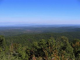
. This highway, a National Scenic Byway since January 2005, runs through the Ouachita National Forest
and the Winding Stair Mountains, and has no shoulders. It features special 'vistas' - parking lots placed off the road at especially scenic parts of the highway. At either end of the Talimena Drive, signs are posted stating that the highway is closed during cold and foggy conditions, and that no snow control is provided.
The height of the mountain peaks on the Drive causes the oaks and pines to grow so much slower and shorter than the rest of Southeast Oklahoma. On a hot summer day, the winds on the Talimena Drive may be a good 10 degrees cooler than other nearby locations.
SH-1 ends at the Arkansas
state line. The roadbed continues on as Highway 88, toward Queen Wilhelmina State Park and the city of Mena, Arkansas.
SH-1 is the latest of many Oklahoma state highways assigned the number 1. The current route opened in 1969. In this case, the number 1 was assigned due to the scenery along the highway.
United States
The United States of America is a federal constitutional republic comprising fifty states and a federal district...
state of Oklahoma
Oklahoma
Oklahoma is a state located in the South Central region of the United States of America. With an estimated 3,751,351 residents as of the 2010 census and a land area of 68,667 square miles , Oklahoma is the 28th most populous and 20th-largest state...
. It travels through the southeastern part of the state, nicknamed Little Dixie
Little Dixie (Oklahoma)
Little Dixie is the name given to the southeast region of Oklahoma, which is heavily influenced by southern "Dixie" culture, as it was settled chiefly by Southerners seeking a start in new lands following the American Civil War...
. Because Oklahoma uses odd numbers for east and west highways (the opposite of U.S. and Interstate highways), SH-1 is signed east and west.
Madill to Ada
SH-1 eastbound begins at US-177/SH-199State Highway 199 (Oklahoma)
State Highway 199, also known as SH-199 or OK-199, is a 44-mile highway in southern Oklahoma. The highway connects Ardmore to Madill as a more northerly alternate to US-70, which much of SH-199 is an old alignment of. It provides access to the Fort Washita Historic Site.-Route description:The...
between Mannsville
Mannsville, Oklahoma
Mannsville is a town in Johnston County, Oklahoma, United States. The population was 587 at the 2000 census.-Geography:Mannsville is located at ....
and Madill
Madill, Oklahoma
Madill is a city in Marshall County, Oklahoma, United States. The city was founded in 1901 and is named for George Alexander Madill, an attorney for the St. Louis-San Francisco Railway, popularly known as the Frisco. The 2009 population estimate was 3,781...
. It then winds northward to the town of Ravia
Ravia, Oklahoma
Ravia is a town in Johnston County, Oklahoma, United States. The population was 459 at the 2000 census.-Geography:Ravia is located at .According to the United States Census Bureau, the town has a total area of , all of it land....
, and becomes concurrent with SH-7
State Highway 7 (Oklahoma)
State Highway 7, often abbreviated as SH-7 or OK-7, is a 150-mile highway in southern Oklahoma. This lengthy highway connects many towns in Oklahoma's "Little Dixie" area. It runs from Interstate 44 in Lawton to U.S...
at through Mill Creek
Mill Creek, Oklahoma
Mill Creek is a town in Johnston County, Oklahoma, United States. The population was 340 at the 2000 census.-Geography:Mill Creek is located at .According to the United States Census Bureau, the town has a total area of , all of it land.-Demographics:...
. Highway 7 splits off to the west soon after and SH-1 continues northward to Hickory, Oklahoma
Hickory, Oklahoma
Hickory is a town in Murray County, Oklahoma, United States. The population was 87 at the 2000 census.-Geography:Hickory is located at .According to the United States Census Bureau, the town has a total area of , all of it land....
and Roff
Roff, Oklahoma
Roff is a town in Pontotoc County, Oklahoma, United States. The population was 734 at the 2000 census.-Geography:Roff is located at...
.
In Fitzhugh
Fitzhugh, Oklahoma
Fitzhugh is a town in Pontotoc County, Oklahoma, United States. The population was 204 at the 2000 census.-Geography:Fitzhugh is located at ....
SH-1 becomes a multilane highway. It then becomes a freeway serving as part of a beltway around Ada
Ada, Oklahoma
Ada is a city in and the county seat of Pontotoc County, Oklahoma, United States. The population was 16,008 at the 2000 census. As of 2009, the city population was estimated at 17,019....
. Through Ada it is briefly concurrent with US-377/SH-99
State Highway 99 (Oklahoma)
State Highway 99, also referred to as SH-99 or OK-99, is a north–south state highway through central Oklahoma. It runs from the Texas border at Lake Texoma to the Kansas border near Lake Hulah. It is long. The highway overlaps US-377 for over half its length.SH-99 links up with K-99 after...
.
Ada to Calvin
After leaving Ada the highway becomes gradually more hilly and curvy, and turns northeast. Between the towns of AllenAllen, Oklahoma
Allen is a town in Hughes and Pontotoc counties in the U.S. state of Oklahoma. The population was 951 at the 2000 census.-Geography:Allen is located on State Highway 1 about northeast of Ada, which is the county seat of Pontotoc County....
and Calvin
Calvin, Oklahoma
Calvin is a town in Hughes County, Oklahoma, United States. The population was 279 at the 2000 census.-Geography:Calvin is located at .According to the United States Census Bureau, the town has a total area of , all of it land....
, the road roughly follows the south bank of the Canadian River
Canadian River
The Canadian River is the longest tributary of the Arkansas River. It is about long, starting in Colorado and traveling through New Mexico, the Texas Panhandle, and most of Oklahoma....
, though the river is not actually visible from the road.
At Calvin, the road becomes concurrent with US-270 and intersects with US-75.
Calvin to Talihina
Through some parts of this section of the highway, the SH-1 signage is omitted in favor of US-270 signs.Continuing east, the highway passes just north of Stuart, Oklahoma
Stuart, Oklahoma
Stuart is a town in Hughes County, Oklahoma, United States. The population was 220 at the 2000 census.-Geography:Stuart is located at .According to the United States Census Bureau, the town has a total area of , all of it land....
and through Arpelar. It then intersects with the Indian Nation Turnpike
Indian Nation Turnpike
The Indian Nation Turnpike is a toll road in southeastern Oklahoma. It is the longest tollway in the state.-Route description:The Indian Nation turnpike is built to parkway-like design standards, omitting a center barrier and left-hand shoulders for a slightly mounded grassy median that is flush...
just west of the McAlester
McAlester, Oklahoma
McAlester is a city in Pittsburg County, Oklahoma, United States. The population was 17,783 at the 2000 census. It is the county seat of Pittsburg County. It is currently the largest city in the Choctaw Nation of Oklahoma, followed by Durant....
city limits. Through McAlester the street is also signed as Carl Albert
Carl Albert
Carl Bert Albert was a lawyer and a Democratic American politician from Oklahoma.Albert represented the southeastern portion of Oklahoma as a Democrat for 30 years, starting in 1947. He is best known for his service as Speaker of the United States House of Representatives from 1971 to 1977...
Parkway.
East of McAlester the road continues as a four-lane road (much of it divided) connecting many small towns east of the city: Krebs
Krebs, Oklahoma
Krebs is a city in Pittsburg County, Oklahoma, United States. The population was 2,051 at the 2000 census.-Geography:Krebs is located at . According to the United States Census Bureau, the city has a total area of , of which, of it is land and 0.29% is water.-Climate:-Attractions:Krebs is famous...
, Alderson
Alderson, Oklahoma
Alderson is a town in Pittsburg County, Oklahoma, United States. The population was 261 at the 2000 census.-Geography:According to the United States Census Bureau, the town has a total area of , all of it land.-Demographics:...
, Bache, Dow, Haileyville
Haileyville, Oklahoma
Haileyville is a city in Pittsburg County, Oklahoma, United States. The population was 891 at the 2000 census.Located in Pittsburg County, Haileyville lies at the junction of U.S. Highway 270/State Highway 1 and State Highway 63, fourteen miles east of McAlester and a little more than one mile west...
, and Hartshorne
Hartshorne, Oklahoma
Hartshorne is a city in Pittsburg County, Oklahoma, United States. The population was 2,102 at the 2000 census. Baseball player Warren Spahn is buried here. Currently, serving as Mayor is Mark Day.-Geography:...
.
West of Hartshorne US-270 splits off from SH-1 and it continues east concurrent with SH-63. For 6 miles (9.7 km) SH-1 and SH-63 overlap State Highway 2
State Highway 2 (Oklahoma)
State Highway 2, abbreviated SH-2 or OK-2, is a designation for two distinct highways maintained by the U.S. state of Oklahoma. Though they were once connected, the middle section of highway was concurrent with three different U.S. highways, so the middle section was decommissioned for reasons of...
. Here the road continues east and becomes even more hilly and curvy as it heads toward the Winding Stair Mountains. From this point forward, the road contains a large number of hairpin turns - some even as drastic as 180-degrees. At Talihina
Talihina, Oklahoma
Talihina is a town in Le Flore County, Oklahoma, United States, its name originating from two Choctaw words, tully and hena, meaning iron road. Iron road is reference to the railroad that the town was built around. It is part of the Fort Smith, Arkansas-Oklahoma Metropolitan Statistical Area...
SH-63 splits off to the south and US-271 merges on to the highway for 8 miles (12.9 km).
The Talimena Drive
Mena, Arkansas
Mena is a city in Polk County, Arkansas, United States. It is also the county seat of Polk County.It was founded by Arthur Edward Stilwell during the building of the Kansas City, Pittsburg and Gulf Railroad . It was Stilwell who decided Mena would be the name of this new town along the route to...
. This highway, a National Scenic Byway since January 2005, runs through the Ouachita National Forest
Ouachita National Forest
The Ouachita National Forest is a National Forest that lies in the western portion of Arkansas and portions of eastern Oklahoma.-History:The Ouachita National Forest is the oldest National Forest in the southern United States. The Forest encompasses , including most of the scenic Ouachita Mountains...
and the Winding Stair Mountains, and has no shoulders. It features special 'vistas' - parking lots placed off the road at especially scenic parts of the highway. At either end of the Talimena Drive, signs are posted stating that the highway is closed during cold and foggy conditions, and that no snow control is provided.
The height of the mountain peaks on the Drive causes the oaks and pines to grow so much slower and shorter than the rest of Southeast Oklahoma. On a hot summer day, the winds on the Talimena Drive may be a good 10 degrees cooler than other nearby locations.
SH-1 ends at the Arkansas
Arkansas
Arkansas is a state located in the southern region of the United States. Its name is an Algonquian name of the Quapaw Indians. Arkansas shares borders with six states , and its eastern border is largely defined by the Mississippi River...
state line. The roadbed continues on as Highway 88, toward Queen Wilhelmina State Park and the city of Mena, Arkansas.
History
State Highway 1 was historically an entrance into Indian Territory from the state of Arkansas. The Oklahoma Choctaw came to these mountain tops in the early 1830s. Stage coach robbers, train robbers and bank robbers all came to hide on these mountain peaks bringing in their horses for much needed breaks. Horse Thief Springs is marked at its vista where one can still rest before continuing down the Drive.SH-1 is the latest of many Oklahoma state highways assigned the number 1. The current route opened in 1969. In this case, the number 1 was assigned due to the scenery along the highway.