

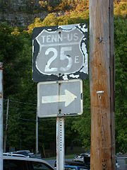
U.S. Route 25E
Encyclopedia
U.S. Route 25E is the eastern branch of U.S. Route 25
from Newport, Tennessee
, where US 25 splits into US 25E and US 25W, to North Corbin, Kentucky
, where the two highways rejoin. The road, however, continues as US 25E for roughly 2 miles (3.2 km) until it joins Interstate 75
in North Corbin.
All of US-25E in Tennessee is now the East Tennessee Crossings Byway, a National Scenic Byway
. A portion of US 25E in Tennessee is also designated as Appalachian Development
Corridor S. The corridor follows US 25E between I-81 in White Pine
and State Route 63 (Corridor F) in Harrogate
.
US 25E has been included in the U.S. Highway System since the system's inception in 1926.
concurrent with one another. At an intersection west of town, US 25 splits into two highways: US 25E, which heads north from this point, and US 25W, which continues west along US 70.
US 25E crosses over Douglas Lake
south of Baneberry
. Between White Pine
and Witt, the highway has an interchange with Interstate 81
(exit 8). North of the Interstate, the road widens out to four lanes, and receives the Appalachian Development designation "Corridor S". US 25E intersects US 11E east of Morristown
. It then crosses Cherokee Reservoir
.
Near Bean Station
, US 25E joins US 11W. The two roads split 3 miles (4.8 km) west of Bean Station, and US 25E continues northwest to Tazewell
.
Northwest of Tazewell, the road bridges the Powell River, and then passes through Harrogate
. In the town of Cumberland Gap, Tennessee
, US 25E serves as the western terminus of US 58. US 25E used that highway en route to the Cumberland Gap
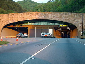
prior to 1996, however, it now uses a new highway leading to the Cumberland Gap Tunnel
, freeing up a portion of road that US 58 now uses. US 25E then passes through the tunnel, emerging on the other side in Kentucky.
 US-25E remains a multilane divided highway for its entire extent in Kentucky. Upon departing the tunnel, the road heads west to the town of Middlesboro, Kentucky, where it intersects Route 74. US-25E turns north at Middlesboro toward Pineville
, the county seat of Bell County
. In Pineville, the route is the western terminus of US-119.
US-25E departs Pineville and heads northwest, indirectly serving Tinsley via KY 92
, crossing into Knox County
, and bypassing Flat Lick to the west. The route makes an S-shaped curve, dipping south then turning back northwest as it approaches Barbourville
. After serving the east side of Barbourville, the highway passes near Heidrick and runs through Baileys Switch.
Between Baileys Switch and Gray, US-25E gradually turns more east–west. After running through Gray, the route serves as the northern terminus of KY 3041. The road then reunites with US-25W north of Corbin
, and the unsuffixed US-25 continues to points north. However, the US-25E designation continues west to Interstate 75
, where it ends at Exit 29.
 Before the Cumberland Gap Tunnel was opened in 1996, US 25E passed through the Cumberland Gap
in Virginia. Prior to the U.S. highway system's arrival, Virginia's State Highway 10 began at the Cumberland Gap and proceeded to Bristol. A short spur south to Tennessee was soon added, becoming State Route 107 in the 1923 renumbering and State Route 100 in the 1928 renumbering.
Early U.S. Highway planning assigned the number U.S. Route 411 to SR 10 through Cumberland Gap to Kentucky, and no number to SR 107. By the final 1926 plan, US 411 was truncated to Cumberland Gap, and US 25E ran from Tennessee to Kentucky along SR 10 and SR 107. The State Route numbers were dropped in the 1933 renumbering.
The Cumberland Gap Tunnel
opened in 1996, completely bypassing Cumberland Gap and Virginia. U.S. Route 58 was moved to a new alignment, meeting US 25E in Tennessee, and US 25E was decommissioned through Virginia. As it lay within the boundaries of the Cumberland Gap National Historical Park
, the National Park Service
now controls the former road, and decided to return it to its pre-pavement state. The pavement was torn up, and old US 25E is now a dirt path.
!colspan=5|Cumberland Gap Tunnel
US-25E leaves Tennessee
!colspan=5|Cumberland Gap Tunnel
US-25E enters Kentucky
U.S. Route 25
U.S. Route 25 is a north–south United States highway that runs for from Brunswick, Georgia to the Ohio state line in Covington, Kentucky.-Georgia:...
from Newport, Tennessee
Newport, Tennessee
Newport is a city in Cocke County, Tennessee, United States. The population was 7,242 at the 2000 census. It is the county seat of Cocke County.-Geography:...
, where US 25 splits into US 25E and US 25W, to North Corbin, Kentucky
North Corbin, Kentucky
North Corbin is a census-designated place in Knox and Laurel counties in the U.S. state of Kentucky. The population was 1,662 at the 2000 census....
, where the two highways rejoin. The road, however, continues as US 25E for roughly 2 miles (3.2 km) until it joins Interstate 75
Interstate 75
Interstate 75 is a major north–south Interstate Highway in the Great Lakes and Southeastern regions of the United States. It travels from State Road 826 and State Road 924 in Hialeah, Florida to Sault Ste. Marie, Michigan, at the Ontario, Canada, border...
in North Corbin.
All of US-25E in Tennessee is now the East Tennessee Crossings Byway, a National Scenic Byway
National Scenic Byway
A National Scenic Byway is a road recognized by the United States Department of Transportation for its archeological, cultural, historic, natural, recreational, and/or scenic qualities. The program was established by Congress in 1991 to preserve and protect the nation's scenic but often...
. A portion of US 25E in Tennessee is also designated as Appalachian Development
Appalachian Development Highway System
The Appalachian Development Highway System is part of the Appalachian Regional Commission in the United States. See: .-History:...
Corridor S. The corridor follows US 25E between I-81 in White Pine
White Pine, Tennessee
White Pine is a town in Hamblen and Jefferson counties in the U.S. state of Tennessee. It is part of the Morristown, Tennessee Metropolitan Statistical Area...
and State Route 63 (Corridor F) in Harrogate
Harrogate, Tennessee
Harrogate is a city in Claiborne County, Tennessee, United States. The community has been known as "Harrogate" since the 19th century, but did not incorporate as a city by that name until 1993....
.
US 25E has been included in the U.S. Highway System since the system's inception in 1926.
Tennessee
Northbound US 25 and westbound US 70 leave NewportNewport, Tennessee
Newport is a city in Cocke County, Tennessee, United States. The population was 7,242 at the 2000 census. It is the county seat of Cocke County.-Geography:...
concurrent with one another. At an intersection west of town, US 25 splits into two highways: US 25E, which heads north from this point, and US 25W, which continues west along US 70.
US 25E crosses over Douglas Lake
Douglas Lake
Douglas Lake, also called Douglas Reservoir, is a reservoir created by an impoundment of the French Broad River in Eastern Tennessee. This lake is located only a few miles from the Pigeon Forge/Gatlinburg area, and also the Great Smoky Mountains National Park...
south of Baneberry
Baneberry, Tennessee
Baneberry is a city in Jefferson County, Tennessee, United States. It is part of the Morristown, Tennessee Metropolitan Statistical Area. The population was 366 at the 2000 census.-Geography:Baneberry is located at ....
. Between White Pine
White Pine, Tennessee
White Pine is a town in Hamblen and Jefferson counties in the U.S. state of Tennessee. It is part of the Morristown, Tennessee Metropolitan Statistical Area...
and Witt, the highway has an interchange with Interstate 81
Interstate 81 in Tennessee
Interstate 81 is an long expressway stretching from Dandridge, Tennessee northward to the Thousand Islands Bridge at the United States-Canada border near Fishers Landing, New York...
(exit 8). North of the Interstate, the road widens out to four lanes, and receives the Appalachian Development designation "Corridor S". US 25E intersects US 11E east of Morristown
Morristown, Tennessee
Morristown is a city in, and the county seat of, Hamblen County, Tennessee, United States. The population was 29,137 at the 2010 United States Census. It is the principal city of the Morristown, Tennessee Metropolitan Statistical Area, which encompasses all of Grainger, Hamblen and Jefferson counties...
. It then crosses Cherokee Reservoir
Cherokee Reservoir
Cherokee Reservoir, also known as Cherokee Lake, is a reservoir in Tennessee formed by the impoundment of the Holston River behind Cherokee Dam.The reservoir has a surface area of about , a flood-storage capacity of , and nearly of shoreline...
.
Near Bean Station
Bean Station, Tennessee
Bean Station is a city in Grainger County, Tennessee, United States. It is part of the Morristown, Tennessee Metropolitan Statistical Area. The city was incorporated in November 1996...
, US 25E joins US 11W. The two roads split 3 miles (4.8 km) west of Bean Station, and US 25E continues northwest to Tazewell
Tazewell, Tennessee
Tazewell is a town in Claiborne County, Tennessee, United States. The population was 2,165 at the 2000 census. It is the county seat of Claiborne County. The town is named for Henry Tazewell , a U.S. senator from Virginia.-Geography:...
.
Northwest of Tazewell, the road bridges the Powell River, and then passes through Harrogate
Harrogate, Tennessee
Harrogate is a city in Claiborne County, Tennessee, United States. The community has been known as "Harrogate" since the 19th century, but did not incorporate as a city by that name until 1993....
. In the town of Cumberland Gap, Tennessee
Cumberland Gap, Tennessee
Cumberland Gap is a town in Claiborne County, Tennessee, near the Cumberland Gap pass, the Cumberland Gap Tunnel, and the Cumberland Gap National Historical Park...
, US 25E serves as the western terminus of US 58. US 25E used that highway en route to the Cumberland Gap
Cumberland Gap
Cumberland Gap is a pass through the Cumberland Mountains region of the Appalachian Mountains, also known as the Cumberland Water Gap, at the juncture of the U.S. states of Tennessee, Kentucky, and Virginia...
prior to 1996, however, it now uses a new highway leading to the Cumberland Gap Tunnel
Cumberland Gap Tunnel
The Cumberland Gap Tunnel is a tunnel that carries U.S. Route 25E under Cumberland Gap National Historical Park near the intersection of Kentucky, Tennessee, and Virginia. The east portal of the tunnel is in Tennessee and the west portal is in Kentucky; according to United States Geological Survey...
, freeing up a portion of road that US 58 now uses. US 25E then passes through the tunnel, emerging on the other side in Kentucky.
Kentucky
Pineville, Kentucky
Pineville is a city in Bell County, Kentucky, United States. The population was 2,093 at the 2000 census. It is the county seat of Bell County. It is located on a small strip of land between the Cumberland River and Pine Mountain.-History:...
, the county seat of Bell County
Bell County, Kentucky
Bell County is a county located in the U.S. state of Kentucky. It was formed August 1, 1867, from parts of Knox and Harlan Counties and augmented from Knox County in 1872. As of 2010 the population was 69,060. Its county seat is Pineville...
. In Pineville, the route is the western terminus of US-119.
US-25E departs Pineville and heads northwest, indirectly serving Tinsley via KY 92
Kentucky Route 92
Kentucky Route 92 is a 84.9 mile long state highway in southern Kentucky. The route runs from Monticello in Wayne County to Pineville in Bell County. Another segment of KY 92 runs from a point at Joppa to the end of the road at Lake Cumberland near Jamestown...
, crossing into Knox County
Knox County, Kentucky
Knox County is a county located in the U.S. state of Kentucky. As of 2000, the population was 31,795. Its county seat is Barbourville. The county is named for General Henry Knox...
, and bypassing Flat Lick to the west. The route makes an S-shaped curve, dipping south then turning back northwest as it approaches Barbourville
Barbourville, Kentucky
Each year in early October, Barbourville hosts the Daniel Boone Festival commemorating the American pioneer Daniel Boone who explored the area in 1775. The festival features open air concerts, carnival attractions, a beauty pageant, a parade, and other events....
. After serving the east side of Barbourville, the highway passes near Heidrick and runs through Baileys Switch.
Between Baileys Switch and Gray, US-25E gradually turns more east–west. After running through Gray, the route serves as the northern terminus of KY 3041. The road then reunites with US-25W north of Corbin
Corbin, Kentucky
- Economy :Originally formed by L&N Railroad, rail transport was the backbone of the local economy in the first half of the twentieth century. While the railroad continues to play an important role, the decline of the rail industry in the latter half of the twentieth century, as well as the loss...
, and the unsuffixed US-25 continues to points north. However, the US-25E designation continues west to Interstate 75
Interstate 75
Interstate 75 is a major north–south Interstate Highway in the Great Lakes and Southeastern regions of the United States. It travels from State Road 826 and State Road 924 in Hialeah, Florida to Sault Ste. Marie, Michigan, at the Ontario, Canada, border...
, where it ends at Exit 29.
History
Cumberland Gap
Cumberland Gap is a pass through the Cumberland Mountains region of the Appalachian Mountains, also known as the Cumberland Water Gap, at the juncture of the U.S. states of Tennessee, Kentucky, and Virginia...
in Virginia. Prior to the U.S. highway system's arrival, Virginia's State Highway 10 began at the Cumberland Gap and proceeded to Bristol. A short spur south to Tennessee was soon added, becoming State Route 107 in the 1923 renumbering and State Route 100 in the 1928 renumbering.
Early U.S. Highway planning assigned the number U.S. Route 411 to SR 10 through Cumberland Gap to Kentucky, and no number to SR 107. By the final 1926 plan, US 411 was truncated to Cumberland Gap, and US 25E ran from Tennessee to Kentucky along SR 10 and SR 107. The State Route numbers were dropped in the 1933 renumbering.
The Cumberland Gap Tunnel
Cumberland Gap Tunnel
The Cumberland Gap Tunnel is a tunnel that carries U.S. Route 25E under Cumberland Gap National Historical Park near the intersection of Kentucky, Tennessee, and Virginia. The east portal of the tunnel is in Tennessee and the west portal is in Kentucky; according to United States Geological Survey...
opened in 1996, completely bypassing Cumberland Gap and Virginia. U.S. Route 58 was moved to a new alignment, meeting US 25E in Tennessee, and US 25E was decommissioned through Virginia. As it lay within the boundaries of the Cumberland Gap National Historical Park
Cumberland Gap National Historical Park
Established on June 11, 1940, Cumberland Gap National Historical Park is a United States National Historical Park located at the border between Kentucky, Tennessee, and Virginia. The Cumberland Gap is a sizable natural break in the Appalachian Mountains....
, the National Park Service
National Park Service
The National Park Service is the U.S. federal agency that manages all national parks, many national monuments, and other conservation and historical properties with various title designations...
now controls the former road, and decided to return it to its pre-pavement state. The pavement was torn up, and old US 25E is now a dirt path.
Tennessee
|-!colspan=5|Cumberland Gap Tunnel
US-25E leaves Tennessee
Kentucky
|-!colspan=5|Cumberland Gap Tunnel
US-25E enters Kentucky