
.gif)
State Route 12 (Utah)
Encyclopedia
State Route 12 or Scenic Byway 12 (SR-12), also known as "Highway 12 — A Journey Through Time Scenic Byway", is a state highway designated an All-American Road located in Garfield County
and Wayne County
, Utah
, USA.
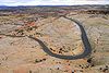 Proceeding west to east for 122 miles (nearly 200 km), the highway starts south of Panguitch
at an intersection with US-89
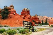
, crosses part of Dixie National Forest
and Bryce Canyon National Park
, continues through the small towns of Tropic
, Cannonville
, and Henrieville
. It crosses various parts of Grand Staircase-Escalante National Monument
(GS-ENM), continues northeast through Escalante
and over the Escalante River
, then north through more of GS-ENM, Boulder
, the Aquarius Plateau
, Grover
, ending in Torrey
at an intersection with SR-24
, five miles (8 km) west of Capitol Reef National Park
. The 30 miles (48.3 km) long portion of the highway that ascends and descends Boulder Mountain
on the Aquarius Plateau is known as Boulder Mountain Highway.
 The road from Bryce Canyon Junction to Tropic
was added to the state highway system in 1914, and in 1923 a branch from Tropic Junction to Bryce Canyon was built as a forest road. The State Road Commission numbered the route to Bryce Canyon SR-12 in the 1920s, and in 1927 the state legislature assigned it to both branches, to Bryce Canyon and Tropic, but split off the branch to Tropic as State Route 54 in 1931. That same year, a new State Route 120 was created, continuing the road from Tropic to Henrieville, and in 1935 it became part of SR-54. Another road was also added to the state highway system in 1914, connecting SR-22 at Widtsoe
with Escalante, and it was numbered State Route 23 in 1927. An extension took SR-23 northeast to Boulder in 1941, and in 1947 SR-54 absorbed SR-23, with the Widtsoe-Escalante road dropped in favor of Henrieville-Escalante. State Route 117, running southeast from SR-24 near Teasdale
to Grover
, became a state highway in 1931, and was extended south to Boulder in 1957, becoming part of SR-54 in 1966. In 1969, SR-54 became part of SR-12, but most of former SR-117 was dropped, leaving SR-12 to stretch from Bryce Canyon Junction to the north limit of Boulder (at the Dixie National Forest
boundary), with a short spur to Bryce Canyon. This spur became a new SR-63 in 1975, and in 1985 the route was extended back north from Boulder to SR-24, using a different route than old SR-117 north of Grover.
Garfield County, Utah
Garfield County is a county located in the U.S. state of Utah. As of 2000 the population was 4,735. It was named for James A. Garfield, President of the United States in 1881. Its county seat and largest city is Panguitch.-Geography:...
and Wayne County
Wayne County, Utah
Wayne County is a county located in the U.S. state of Utah. It was formed from Piute County in 1892. The county gets its name from a man who served as delegate to the constitutional convention, in honor of his son who was dragged to death by a horse. As of 2000 the population was 2,509, and by...
, Utah
Utah
Utah is a state in the Western United States. It was the 45th state to join the Union, on January 4, 1896. Approximately 80% of Utah's 2,763,885 people live along the Wasatch Front, centering on Salt Lake City. This leaves vast expanses of the state nearly uninhabited, making the population the...
, USA.
Route description
Panguitch, Utah
Panguitch is a city in and the county seat of Garfield County, Utah, United States. The population was 1,623 at the 2000 census.-Geography:Panguitch is located at ....
at an intersection with US-89
U.S. Route 89 in Utah
In the U.S. state of Utah, U.S. Route 89 is a long north–south state highway spanning more than through the central part of the state. Between Provo and Brigham City, US-89 serves as a local road, paralleling Interstate 15, but the portions from Arizona north to Provo and Brigham City...
, crosses part of Dixie National Forest
Dixie National Forest
Dixie National Forest is a United States National Forest in Utah with headquarters in Cedar City. It occupies almost two million acres and stretches for about 170 miles across southern Utah. The largest national forest in Utah, it straddles the divide between the Great Basin and the Colorado River...
and Bryce Canyon National Park
Bryce Canyon National Park
Bryce Canyon National Park is a national park located in southwestern Utah in the United States. The major feature of the park is Bryce Canyon which, despite its name, is not a canyon but a giant natural amphitheater created by erosion along the eastern side of the Paunsaugunt Plateau...
, continues through the small towns of Tropic
Tropic, Utah
Tropic is a town in Garfield County, Utah, United States, along Utah Scenic Byway 12. As of the 2000 census, the town had a total population of 508...
, Cannonville
Cannonville, Utah
Cannonville is a town in Garfield County, Utah, United States, along Utah Scenic Byway 12. In the 2000 census, the population was 148, a small increase over the 1990 figure of 131.-Geography:Cannonville is located at ....
, and Henrieville
Henrieville, Utah
Henrieville is a town in Garfield County, Utah, United States, along Utah Scenic Byway 12. As of the 2000 census, the town population was 159.-Geography:Henrieville is located at ....
. It crosses various parts of Grand Staircase-Escalante National Monument
Grand Staircase-Escalante National Monument
The Grand Staircase-Escalante National Monument contains 1.9 million acres of land in southern Utah, the United States. There are three main regions: the Grand Staircase, the Kaiparowits Plateau, and the Canyons of the Escalante. President Bill Clinton designated the area as a U.S. National...
(GS-ENM), continues northeast through Escalante
Escalante, Utah
Escalante is a city in Garfield County, Utah, United States, along Utah Scenic Byway 12. As of the 2000 census, the city population was 818.The town was named after Silvestre Vélez de Escalante, a Franciscan missionary and the first European explorer in the region...
and over the Escalante River
Escalante River
right|Location of the Escalante River within UtahThe Escalante River is a tributary of the Colorado River. It is formed by the confluence of North and Birch Creeks near the town of Escalante in south-central Utah, and from there flows southeast for approximately before joining Lake Powell...
, then north through more of GS-ENM, Boulder
Boulder, Utah
Boulder is a town in Garfield County, Utah, United States, 27 miles northeast of Escalante on Utah Scenic Byway 12 at its intersection with the Burr Trail...
, the Aquarius Plateau
Aquarius Plateau
The Aquarius Plateau is a physiographic region within Garfield and Wayne counties in south-central Utah. The plateau, an uplift on the much larger Colorado Plateau, is the highest in North America...
, Grover
Grover, Utah
-External links:*...
, ending in Torrey
Torrey, Utah
Torrey is a town located on State Route 24 in Wayne County, Utah, eight miles from Capitol Reef National Park. As of the 2000 census, the town had a total population of 171....
at an intersection with SR-24
Utah State Route 24
State Route 24 is a state highway in south central Utah which runs south from Salina through Sevier County then east through Wayne County and north east through Emery County...
, five miles (8 km) west of Capitol Reef National Park
Capitol Reef National Park
Capitol Reef National Park is a United States National Park, in south-central Utah. It is 100 miles long but fairly narrow. The park, established in 1971, preserves 378 mi² and is open all year, although May through September are the most popular months.Called "Wayne Wonderland" in the 1920s...
. The 30 miles (48.3 km) long portion of the highway that ascends and descends Boulder Mountain
Boulder Mountain (Utah)
Boulder Mountain in Utah, USA makes up half of the Aquarius Plateau of South Central Utah in Wayne and Garfield counties. The mountain rises to the west of Capitol Reef National Park and consists of steep slopes and cliffs with over 50,000 acres of rolling forest and meadowlands on the top...
on the Aquarius Plateau is known as Boulder Mountain Highway.
Traffic volume
The Average Daily Traffic (AADT) on SR-12 is at its greatest at its western junction with US-89, where the count for 2005 was 2,430. At its other end, at the junction with SR-24, the traffic bottoms out at 435.History
Tropic, Utah
Tropic is a town in Garfield County, Utah, United States, along Utah Scenic Byway 12. As of the 2000 census, the town had a total population of 508...
was added to the state highway system in 1914, and in 1923 a branch from Tropic Junction to Bryce Canyon was built as a forest road. The State Road Commission numbered the route to Bryce Canyon SR-12 in the 1920s, and in 1927 the state legislature assigned it to both branches, to Bryce Canyon and Tropic, but split off the branch to Tropic as State Route 54 in 1931. That same year, a new State Route 120 was created, continuing the road from Tropic to Henrieville, and in 1935 it became part of SR-54. Another road was also added to the state highway system in 1914, connecting SR-22 at Widtsoe
Widtsoe, Utah
Widtsoe is a ghost town in Garfield County, Utah, United States. Located in John's Valley northeast of Bryce Canyon and along the Sevier River at the mouth of Sweetwater Creek, the town existed about 1908–1936.-History:...
with Escalante, and it was numbered State Route 23 in 1927. An extension took SR-23 northeast to Boulder in 1941, and in 1947 SR-54 absorbed SR-23, with the Widtsoe-Escalante road dropped in favor of Henrieville-Escalante. State Route 117, running southeast from SR-24 near Teasdale
Teasdale, Utah
Teasdale is a census-designated place in western Wayne County, Utah, United States, between the Dixie and Fishlake National Forests. The population was 191 at the 2010 census. Teasdale lies along local roads south of State Route 24, southeast of the town of Loa, the county seat of Wayne County...
to Grover
Grover, Utah
-External links:*...
, became a state highway in 1931, and was extended south to Boulder in 1957, becoming part of SR-54 in 1966. In 1969, SR-54 became part of SR-12, but most of former SR-117 was dropped, leaving SR-12 to stretch from Bryce Canyon Junction to the north limit of Boulder (at the Dixie National Forest
Dixie National Forest
Dixie National Forest is a United States National Forest in Utah with headquarters in Cedar City. It occupies almost two million acres and stretches for about 170 miles across southern Utah. The largest national forest in Utah, it straddles the divide between the Great Basin and the Colorado River...
boundary), with a short spur to Bryce Canyon. This spur became a new SR-63 in 1975, and in 1985 the route was extended back north from Boulder to SR-24, using a different route than old SR-117 north of Grover.
Major intersections
| County | Location | Mile | Destinations | Notes |
|---|---|---|---|---|
| Garfield | Bryce Canyon Junction | 0.000 | ||
| 10.713 | East Fork of the Sevier Scenic Backway | |||
| Tropic Junction | 13.598 | Former SR-22 | ||
| Cannonville | 25.657 | Cottonwood Canyon Scenic Backway – Kodachrome Basin State Park Kodachrome Basin State Park Kodachrome Basin is a state park of Utah, USA. It is situated above sea level, south of Utah Route 12, and southeast of Bryce Canyon National Park. It is accessible from the north from Cannonville by a paved road and from the south by Road 400, a dirt road from the Page, Arizona area to... |
||
| 54.643 | Main Canyon Road | Former SR-23 | ||
| Escalante | 58.968 | Smokey Mountain Scenic Backway | ||
| 59.830 | Posey Lake Scenic Backway | |||
| 64.392 | Hole-in-the-Rock Scenic Backway | |||
| 83.270 | Hell's Backbone Road Hell's Backbone Road Hell's Backbone Road is a 38-mile gravel road that was built by the Civilian Conservation Corps in the 1930s, and connects the towns of Boulder, Utah and Escalante, Utah. Half-way along the road is Hell's Backbone Bridge, which is long, and wide. A drop is on either side. Near the bridge are... |
|||
| Boulder | 86.352 | Burr Trail Scenic Backway Burr Trail Scenic Backway The Burr Trail Scenic Backway is a backcountry route extending from the town of Boulder, Utah, through Grand Staircase-Escalante National Monument into Capital Reef National Park and then to the community of Bullfrog in Glen Canyon National Recreation Area.... |
||
| Wayne | 118.179 | Teasdale Teasdale, Utah Teasdale is a census-designated place in western Wayne County, Utah, United States, between the Dixie and Fishlake National Forests. The population was 191 at the 2010 census. Teasdale lies along local roads south of State Route 24, southeast of the town of Loa, the county seat of Wayne County... |
Former SR-117 | |
| 122.863 |
External links
- Map and more from the DOT'sUnited States Department of TransportationThe United States Department of Transportation is a federal Cabinet department of the United States government concerned with transportation. It was established by an act of Congress on October 15, 1966, and began operation on April 1, 1967...
American Byways website - State of Utah's website for the highway