
.gif)
M-28 (Michigan highway)
Encyclopedia
M-28 is an east–west state trunkline highway
that almost completely traverses the Upper Peninsula
in the U.S. state of Michigan
, from Wakefield
to near Sault Ste. Marie
in Bruce Township
. Along with US Highway 2
(US 2), M-28 forms a pair of primary highways linking the Upper Peninsula from end to end, providing a major access route for traffic from Michigan and Canada
along the southern shore of Lake Superior
. M-28 is the longest state trunkline in Michigan numbered with the "M-" prefix at 290.373 miles (467.309 km). The entire highway is listed on the National Highway System
, while three sections of M-28 are part of the Lake Superior Circle Tour. M-28 also carries two memorial highway designations along its route.
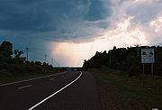
Throughout its course across the Upper Peninsula, M-28 passes through forested woodlands, bog swamps, urbanized areas, and along the Lake Superior shoreline. Sections of roadway cross the Ottawa National Forest
and both units of the Hiawatha National Forest
. Some of the other landmarks accessible from M-28 include the Seney Stretch, Seney National Wildlife Refuge
and several historic bridges.
M-28 is an original trunkline designation, dating to the 1919 formation of the state's trunkline system. The original highway was much shorter than the current version. M-28 was expanded eastward to the Sault Ste. Marie area in the late 1920s. The western end has been expanded twice to different locations on the Wisconsin
state line. Other changes along the routing have led to the creation of three different business loops at various times, with one still extant. Future changes, proposed by Marquette County but not accepted by the Michigan Department of Transportation
(MDOT), could see M-28 rerouted over County Road 480 (CR 480).
 M-28 is a major highway for Michigan and Canadian traffic along the south shore of Lake Superior. It forms the northern half of a pair of primary trunklines linking the Upper Peninsula from end to end; US 2
is the southern partner. The 290.373 miles (467.3 km) highway comprises mostly two lanes, undivided except for sections that are concurrent
with US 41
near Marquette
. The "Marquette Bypass" portion of US 41/M-28 is a four-lane expressway
, and segments of the highway in Marquette County
have four lanes. The entire route is part of the National Highway System, and three sections of the trunkline are part of the Lake Superior Circle Tour.
, the trunkline highway skirts the northern shore of Lake Gogebic
, running concurrently with M-64
. The first section of M-28 designated as a part of the Lake Superior Circle Tour is from the western terminus to the eastern junction with M-64 in Bergland, where the Circle Tour turns north along M-64, leaving M-28. Here, M-28 has its lowest traffic counts; within the 2006 MDOT survey, the road is listed with only an average annual daily traffic (AADT) of 1,400 vehicles on a section of highway between Bergland and Bruce Crossing
. The trunkline runs through heavily forested areas of southern Houghton
and Baraga counties
. At the eastern junction with US 41 near Covington, M-28 receives the Circle Tour designation again and exits the Ottawa National Forest
.
In Baraga and Marquette counties, US 41/M-28 passes through hilly terrain before entering the urban areas of Ishpeming, Negaunee and Marquette. Approximately 13,000 vehicles use this section from Ishpeming eastward through Negaunee. West of the city of Marquette, US 41/M-28 had a peak 2006 AADT of 34,700 vehicles in Marquette Township
along a retail and business corridor. This peak level is sustained until the start of the Marquette Bypass, where the traffic returns to the 14,000-vehicle and higher levels seen in Ishpeming and Negaunee. South of the city of Marquette, traffic counts once again climb above 20,000 vehicles. In Chocolay Township the AADT drops to 8,100 vehicles before tapering off to 3,500 vehicles by the county line.
At the Ishpeming–Negaunee city line, M-28 changes memorial highway designations. From the western terminus to this point, M-28 is called the "Veterans Memorial Highway", but it becomes the "D. J. Jacobetti
Memorial Highway" to honor the longest-serving member of the Michigan Legislature
. The Jacobetti Highway designation ends at the eastern M-123 junction in Chippewa County
.
 Between Marquette and Munising
, M-28 closely parallels the Lake Superior
shoreline, providing scenic views of the lake and its "lonesome sandy beaches". The Lakenenland Sculpture Park is located in Chocolay Township near Shot Point in eastern Marquette County. This roadside attraction is owned by Tom Lakenen and features fanciful works of art made of scrap iron. Near the community of Au Train
, M-28 crosses into the western unit of the Hiawatha National Forest
. West of Munising is a ferry dock offering transport to the Grand Island National Recreation Area
, and at Munising there is easy access to Pictured Rocks National Lakeshore
. The roadway also features variable message signs to warn motorists of winter weather-related traffic closures along the lakeshore. Installed at the US 41 and M-94
junctions, the signs advise motorists which sections of roadway are closed. Per MDOT policy, only snowplows are allowed on these sections during a closure. The highway exits the Hiawatha National Forest at the Alger County
–Schoolcraft County
line along the Seney Stretch.
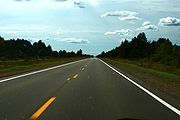 The portion of M-28 between Seney and Shingleton, called the Seney Stretch, is 25 miles (40 km) of "straight-as-an-arrow highway" across the Great Manistique Swamp
, "though others claim it's 50 miles (80.5 km), only because it seems longer." The Seney Stretch is the longest such section of highway in the state, and "one of the longest stretches of curveless highway east of the Mississippi
." The highway is often cited as the "state's most boring route" according to the Michigan Economic Development Corporation (MEDC) and Hunts' Guide. The straightness and flatness over a great distance are given as reasons for the reputation of this stretch as boring.
The road across the swamp was constructed parallel to the line of the Duluth, South Shore and Atlantic Railway
(later the Soo Line Railroad
). It was first numbered as a part of M-25
when that designation was used along today's M-28 east of US 41. The most significant changes made to the stretch since its original construction were the addition of passing relief lanes
and a full-scale, year-round rest area
in 1999.
Part of the Seney Stretch forms the northern border of the Seney National Wildlife Refuge
. Established in 1935, this refuge is a managed wetland
in Schoolcraft County
. It has an area of 95212 acres (385 km²), and contains the Strangmoor Bog National Natural Landmark
within its boundaries.
 Past Seney, M-28 once again enters woodlands on the eastern end of the Upper Peninsula. In Luce County
, the roadway passes through the community of McMillan
en route to Newberry
. The Circle Tour departs M-28 to follow M-123
at Newberry, looping north to the Tahquamenon Falls State Park
. East of town, the road passes Luce County Airport off of Luce CR 399. From there, M-28 crosses the east and west branches of the Sage River and passes south of Soo Junction
, before the Chippewa County
border.
In Chippewa County, M-28 begins bending slightly east-northeastward. Hulbert Lake is located south of Hulbert; north of the lake, the highway enters the eastern unit of the Hiawatha National Forest. At the eastern junction of M-28 and M-123 near Eckerman and Strongs, the Circle Tour returns to M-28 and the D.J. Jacobetti Memorial Highway designation ends. The highway leaves the eastern unit of the Hiawatha National Forest between the communities of Raco and Brimley. M-221
leads north from the main highway on an old routing of M-28 to connect to the community of Brimley and the Bay Mills Indian Community
. Brimley State Park
is just east of Brimley on the old 6 Mile Road alignment of M-28. The highway meets I-75
at exit 386, and the Lake Superior Circle Tour departs M-28 to follow I-75. This interchange is just west of H-63
/Mackinac Trail
, a former segment of US 2. M-28 continues 3 miles (5 km) farther to its eastern terminus with M-129
.
 Along the routing of M-28, MDOT has established several roadside parks and rest areas. Two of these are in Ontonagon County near Ewen and Trout Creek. A park with a picnic area, and a footbridge lies near Tioga Creek in Baraga County
east of the US 41 junction. In Three Lakes a scenic turnout and a roadside park overlook Lake Michigamme
, and along Lake Superior south of Marquette is a tourist information center built as a log cabin. East of the H-01 junction in Au Train
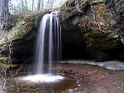
is a roadside park that includes Scott Falls
. Further east, a year-round rest area is located on the west end of the Seney Stretch. Three other roadside parks lie east of Harvey in Shelter Bay, on the shores of Deer Lake and west of Newberry.
at a junction with then M-12
and ran roughly along the current alignment to end at M-15
, 6.5 miles (10.5 km) east of Covington
. These two termini roughly correspond to the modern US 2
and western US 41
junctions respectively. M-28 was extended in 1927 along US 41 into Marquette County
and east over M-25
through Chatham
, Munising
, and Newberry
, before ending in downtown Sault Ste. Marie
. At Negaunee, M-28 took the former routing of M-15 between Negaunee
and Marquette
for 10 miles (16 km) while US 41 ran along a portion of M-35
. This southern loop routing of M-28 lasted until approximately 1936, when M-28 was moved to US 41, and the former route became CR 492
. A new routing of M-28 in the Newberry area opened later that year, and a new M-28A (later BUS M-28
) existed until 1953. Another realignment in 1937 marked the transfer of M-28 out of downtown Ishpeming
and Negaunee. This former routing later became BUS M-28
.
In 1941, the routings of M-28 and M-94
were reversed between Harvey
and Munising. Since then, M-28 has run along the lakeshore through Au Train
. M-28 was extended along US 2 to the state line at Ironwood
, and the eastern end of M-28 through Brimley was moved to a new alignment ending at US 2, in Dafter in 1942. The eastern end was moved along US 2 back to Sault Ste. Marie in 1948, though the terminus was returned to Dafter in 1950.
From 1952 to 1962, M-28 crossed US 2 at Wakefield going south and stopped at the Wisconsin
border, connecting with a county road. This segment of the highway (now Gogebic CR 519) was transferred back to the county in 1962. M-94 previously looped along Munising-Van Meer-Shingleton Road (now H-58
and H-15) north of M-28 between Munising and Shingleton. This routing was abandoned on November 7, 1963 in favor of the current concurrency
. The last significant change to the M-28 routing occurred on March 3, 1989, when the eastern terminus was moved east to M-129
.
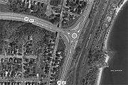 MDOT unveiled plans on March 31, 2009, to rebuild the intersection between Front Street and the eastern end of the Marquette Bypass during 2010. The rebuilt intersection would take the form of a roundabout
, replacing several intersecting roadways that connect the north and south sections of Front Street with US 41/M-28 through the existing intersection. The previous intersection configuration dated back to the 1960s. It had been labeled as "dangerous and [causing] significant traffic delays" by the designers of the replacement. A traffic study concluded in 2007 that the intersection would need either the roundabout or a traffic signal with several turning lanes to accommodate the traffic needs in the area. MDOT decided in favor of a two-lane, 150 feet (45.7 m) roundabout retaining the right-turn lanes from the previous intersection layout. These lanes will be used by right-turning traffic to bypass the circle at the center of the intersection.
The upgraded intersection had been a part of the City of Marquette's master plan since 2003. MDOT engineers touted the constant-flowing nature of the design as a benefit to the new intersection, and city planners promoted the enhanced safety aspects of the project. Both parties stated the planned intersection was less expensive than a conventional stop light.
Residents have expressed concerns about snow plowing and truck traffic in the intersection. The designers consulted officials of Avon, Colorado
, where several roundabouts are situated in a location that averages over 300 inches (762 cm) of annual snowfall. Designers planned the size of the new intersection to accommodate truck traffic. MDOT has stated that many of the concerns expressed are due to misconceptions and unfounded assumptions about the design. The department held an informational meeting with the residents on April 15, 2010 before construction began. Topics ranges from emergency vehicles, plowing, trucks, accidents and detour plans.
Construction started on the project in May. One lane of traffic in each direction was maintained for US 41/M-28. Motorist seeking access to downtown were detoured via Grove Street or Lakeshore Boulevard. The Downtown Development Authority had plans to purchase billboards helping to direct customers to the downtown shopping district. A section of the intersection was opened in July to traffic from the south that turns west. The lanes northbound into downtown were opened in the beginning of August, and the city held a ribbon cutting ceremony on August 19, 2010. The remaining lanes were opened the next day. To address residents' concerns about truck traffic through the intersection, the mayor note that truck used the roundabout after the ribbon was cut. "It just cruised right around and through. All of these people who are wondering is it big enough, can you get a firetruck on it? Yes, you can," stated Mayor John Kivela.
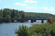
bridges along the route of M-28 on the MDOT website. In Interior Township
, Ontonagon County
, the highway crosses the Ontonagon River
over a bridge built in 1929. Designed by the State Highway Department and built by the firm of Meads and Anderson, the Ontonagon River Bridge is one of only three steel arch bridges in Michigan. The main span arch is 150 feet (46 m) long. A former routing of M-28 in Covington Township
crosses the Rock River. Although this section was bypassed by a new alignment of the trunkline in 1924, the bridge remains complete "with corbeled bulkheads and six panels recessed in the concrete spandrel walls." The corbel
s and spandrel
s are decorative features found in the concrete sides of the bridge.
 Today, drivers cannot use the Peshekee River Bridge
south of US 41/M-28 in western Marquette County
's Michigamme Township
. The bridge was listed on the National Register of Historic Places in 1999 as "Trunk Line Bridge No. 1" for its engineering and architectural significance. MDOT has listed it as "one of Michigan's most important vehicular bridges." It was the first bridge designed by the Michigan State Highway Department, the forerunner to MDOT, in 1914. It was bypassed by a newer bridge built over the Peshekee River on US 41/M-28 subsequently abandoned as a roadway. The replacement bridge was bypassed and demolished in 1995.
The next historic bridge listed by MDOT along M-28 is over the Sand River
in Onota Township
in Alger County
. While not visible to motorists, the bridge, constructed in 1939, is the longest rural rigid-frame span in Michigan. Most bridges of this type were built in urban locations, and soil conditions in the state limit locations for this style of bridge. The bridge over the East Branch of the Tahquamenon River
in Chippewa County
was built in 1926 as a "formative exercise in what would evolve into a state standard design." The 55 feet (17 m) bridge was built with nine lines of I-beam
s encased in concrete. Only one other bridge in Michigan was built with such concrete encasement.
 In the August 24, 2005 edition, the Marquette Mining Journal reported that the Marquette County
Board and the County Road Commission were negotiating with MDOT to transfer the jurisdiction of Marquette County Road 480 to the state. Several routing options have been discussed, though all would make CR 480 a part of M-28. Cost was the primary reason given behind rerouting M-28 along CR 480. "The road commission receives about $50,000 a year in state gas tax money but spends about $100,000 to maintain CR 480 because of the type and volume of traffic it receives." Handing CR 480 over to the state would shift the maintenance costs to the state, as well.
MDOT has indicated that it has not requested jurisdiction, but rather if it assumed control of the route, the community would need to support a through-route. Several proposals have arisen, including creating a "spur" from US 41/M-28 through the east end of Ishpeming to meet CR 480 west of Negaunee. This spur would pass through recently reopened former mining "caving grounds", and to the south of the Mather A & B Mine complex. According to Gerry Corkin, Marquette County Board Chairman, "the land that was purchased by Ishpeming and Negaunee, the mining company land, this has the potential to help in the development of that if this is compatible. I think both cities will be interested in taking a look at what the land uses are and where this [spur] would push through."
The spur proposal would open land to development between the downtown areas of the two cities. If jurisdiction is transferred, and M-28 is routed over CR 480 as proposed, M-28 would leave the concurrency with US 41 near Teal Lake in Negaunee, and cross the caving grounds west of downtown to connect to Rail Street. Rail Street would serve as the connector to CR 480, which ends at the intersection of Rail and Ann streets and Healey Avenue. Proposals indicate two routing options for the east end of CR 480. One would route M-28 back along US 41 from Beaver Grove north of the CR 480 eastern terminus to the existing M-28 in Harvey. A second would route it along CR 551/Cherry Creek Road from CR 480 to M-28 in Harvey.
 BUS US 41 in Marquette was first shown on a map in 1964 after the construction of the Marquette Bypass. It was later designated BUS US 41/BUS M-28 on a map in 1975; this second designation was removed from maps by 1982. The entire business loop was turned back to local control in a "route swap" between the City of Marquette and MDOT announced in early 2005. The proposal transferred jurisdiction on the unsigned M-554
and the business route from the state to the city. The state would take jurisdiction over a segment of McClellan Avenue to be used to extend M-553
to US 41/M-28. In addition, MDOT would pay $2.5 million (equivalent to $ in ) for reconstruction work planned for 2007. The transfer would increase Marquette's operational and maintenance liability expenses by $26,000 (equivalent to $ in ) and place the financial burden of the future replacement of a stop light on the city.. On October 10, 2005, MDOT and Marquette transferred jurisdiction over the three roadways. As a result, BUS US 41 was decommissioned when the local government took control over Washington and Front streets. As a result of the decommissioning, the 2006 maps did not show the now former business loop.
The Newberry BUS M-28 was designated from 1936 until 1952 as M-28A. The MSHD maps of the time showed it signed as BUS M-28 in 1952 before it was turned back to local control in 1953.
Michigan Highway System
The Michigan State Trunkline Highway System is made up of all the highways designated as Interstates, U.S. Highways and State Highways in the US state of Michigan. The system is maintained by the Michigan Department of Transportation and comprises of trunklines in all 83 counties of Michigan on...
that almost completely traverses the Upper Peninsula
Upper Peninsula of Michigan
The Upper Peninsula of Michigan is the northern of the two major land masses that make up the U.S. state of Michigan. It is commonly referred to as the Upper Peninsula, the U.P., or Upper Michigan. It is also known as the land "above the Bridge" linking the two peninsulas. The peninsula is bounded...
in the U.S. state of Michigan
Michigan
Michigan is a U.S. state located in the Great Lakes Region of the United States of America. The name Michigan is the French form of the Ojibwa word mishigamaa, meaning "large water" or "large lake"....
, from Wakefield
Wakefield, Michigan
Wakefield is a city in Gogebic County in the US state of Michigan. It is located in the western Upper Peninsula. The population was 1,851 at the 2010 census....
to near Sault Ste. Marie
Sault Ste. Marie, Michigan
Sault Ste. Marie is a city in and the county seat of Chippewa County in the U.S. state of Michigan. It is in the north-eastern end of Michigan's Upper Peninsula, on the Canadian border, separated from its twin city of Sault Ste. Marie, Ontario, by the St. Marys River...
in Bruce Township
Bruce Township, Chippewa County, Michigan
Bruce Township is a civil township of Chippewa County in the U.S. state of Michigan. As of the 2000 census, the township population was 1,940.-Communities:...
. Along with US Highway 2
U.S. Route 2 in Michigan
US Highway 2 is a component of the United States Numbered Highway System that connects Everett, Washington, to the Upper Peninsula of the US state of Michigan, with a separate segment that runs from Rouses Point, New York, to Houlton, Maine...
(US 2), M-28 forms a pair of primary highways linking the Upper Peninsula from end to end, providing a major access route for traffic from Michigan and Canada
Canada
Canada is a North American country consisting of ten provinces and three territories. Located in the northern part of the continent, it extends from the Atlantic Ocean in the east to the Pacific Ocean in the west, and northward into the Arctic Ocean...
along the southern shore of Lake Superior
Lake Superior
Lake Superior is the largest of the five traditionally-demarcated Great Lakes of North America. It is bounded to the north by the Canadian province of Ontario and the U.S. state of Minnesota, and to the south by the U.S. states of Wisconsin and Michigan. It is the largest freshwater lake in the...
. M-28 is the longest state trunkline in Michigan numbered with the "M-" prefix at 290.373 miles (467.309 km). The entire highway is listed on the National Highway System
National Highway System (United States)
The National Highway System is a network of strategic highways within the United States, including the Interstate Highway System and other roads serving major airports, ports, rail or truck terminals, railway stations, pipeline terminals and other strategic transport facilities.Individual states...
, while three sections of M-28 are part of the Lake Superior Circle Tour. M-28 also carries two memorial highway designations along its route.
Throughout its course across the Upper Peninsula, M-28 passes through forested woodlands, bog swamps, urbanized areas, and along the Lake Superior shoreline. Sections of roadway cross the Ottawa National Forest
Ottawa National Forest
The Ottawa National Forest is a 1.0 million acre national forest in the Upper Peninsula of the U.S. state of Michigan. It includes much of Gogebic and Ontonagon counties, as well as slices of Iron, Houghton, Baraga, and Marquette counties. The forest is under the jurisdiction of the U.S...
and both units of the Hiawatha National Forest
Hiawatha National Forest
Hiawatha National Forest is a National Forest in the Upper Peninsula of the state of Michigan in the United States. Commercial logging is conducted in some areas. The United States Forest Service administers this National Forest; it is physically divided into two subunits, commonly called the...
. Some of the other landmarks accessible from M-28 include the Seney Stretch, Seney National Wildlife Refuge
Seney National Wildlife Refuge
The Seney National Wildlife Refuge is a managed wetland in Schoolcraft County in the U.S. state of Michigan. It has an area of 95,212 acres . It is bordered by M-28 and M-77. The nearest town of any size is Seney, Michigan...
and several historic bridges.
M-28 is an original trunkline designation, dating to the 1919 formation of the state's trunkline system. The original highway was much shorter than the current version. M-28 was expanded eastward to the Sault Ste. Marie area in the late 1920s. The western end has been expanded twice to different locations on the Wisconsin
Wisconsin
Wisconsin is a U.S. state located in the north-central United States and is part of the Midwest. It is bordered by Minnesota to the west, Iowa to the southwest, Illinois to the south, Lake Michigan to the east, Michigan to the northeast, and Lake Superior to the north. Wisconsin's capital is...
state line. Other changes along the routing have led to the creation of three different business loops at various times, with one still extant. Future changes, proposed by Marquette County but not accepted by the Michigan Department of Transportation
Michigan Department of Transportation
The Michigan Department of Transportation is a constitutional government agency in the US state of Michigan. The primary purpose of MDOT is to maintain the Michigan State Trunkline Highway System which includes all Interstate, US and state highways in Michigan with the exception of the Mackinac...
(MDOT), could see M-28 rerouted over County Road 480 (CR 480).
Route description
U.S. Route 2 in Michigan
US Highway 2 is a component of the United States Numbered Highway System that connects Everett, Washington, to the Upper Peninsula of the US state of Michigan, with a separate segment that runs from Rouses Point, New York, to Houlton, Maine...
is the southern partner. The 290.373 miles (467.3 km) highway comprises mostly two lanes, undivided except for sections that are concurrent
Concurrency (road)
A concurrency, overlap, or coincidence in a road network is an instance of one physical road bearing two or more different highway, motorway, or other route numbers...
with US 41
U.S. Route 41 in Michigan
US Highway 41 is a part of the United States Numbered Highway System that runs from Miami, Florida, to the Upper Peninsula of the US state of Michigan. In Michigan, it is a state trunkline highway that enters the state via the Interstate Bridge between Marinette, Wisconsin, and Menominee,...
near Marquette
Marquette, Michigan
Marquette is a city in the U.S. state of Michigan and the county seat of Marquette County. The population was 21,355 at the 2010 census, making it the most populated city of the Upper Peninsula. Marquette is a major port on Lake Superior, primarily for shipping iron ore and is the home of Northern...
. The "Marquette Bypass" portion of US 41/M-28 is a four-lane expressway
Limited-access road
A limited-access road known by various terms worldwide, including limited-access highway, dual-carriageway and expressway, is a highway or arterial road for high-speed traffic which has many or most characteristics of a controlled-access highway , including limited or no access to adjacent...
, and segments of the highway in Marquette County
Marquette County, Michigan
-National protected areas:* Hiawatha National Forest * Huron National Wildlife Refuge* Ottawa National Forest -University:Northern Michigan University is a four-year university, established in 1899, located in Marquette, Michigan, on Michigan's Upper Peninsula...
have four lanes. The entire route is part of the National Highway System, and three sections of the trunkline are part of the Lake Superior Circle Tour.
Western terminus to Shingleton
In the west, M-28 begins at a signalized intersection with US 2 in Wakefield. Heading north, the highway passes Sunday Lake heading out of town. In southwestern Ontonagon CountyOntonagon County, Michigan
-National protected areas:* Keweenaw National Historical Park * Ottawa National Forest -Demographics:As of the census of 2000, there were 7,818 people, 3,456 households, and 2,225 families residing in the county. The population density was 6 people per square mile . There were 5,404 housing units...
, the trunkline highway skirts the northern shore of Lake Gogebic
Lake Gogebic
Lake Gogebic is the largest lake of the Upper Peninsula of Michigan. It is located within the 1 million acre Ottawa National Forest. Lake Gogebic State Park is located along its western shore....
, running concurrently with M-64
M-64 (Michigan highway)
M-64 is a north–south state trunkline highway in the Upper Peninsula of the US state of Michigan. It runs for through the western part of the state in land that is part of the Ottawa National Forest. The highway connects with County Trunk Highway B at the state line near Presque Isle, Wisconsin....
. The first section of M-28 designated as a part of the Lake Superior Circle Tour is from the western terminus to the eastern junction with M-64 in Bergland, where the Circle Tour turns north along M-64, leaving M-28. Here, M-28 has its lowest traffic counts; within the 2006 MDOT survey, the road is listed with only an average annual daily traffic (AADT) of 1,400 vehicles on a section of highway between Bergland and Bruce Crossing
Bruce Crossing, Michigan
Bruce Crossing is an unincorporated community in Ontonagon County, Michigan, United States. Bruce Crossing is located in Stannard Township at the junction of U.S. Route 45 and M-28, south-southeast of Ontonagon. Bruce Crossing has a post office with ZIP code 49912.- History :Bruce Crossing was...
. The trunkline runs through heavily forested areas of southern Houghton
Houghton County, Michigan
-National protected areas:* Keweenaw National Historical Park * Ottawa National Forest -Demographics:As of the census of 2000, there were 36,016 people, 13,793 households, and 8,137 families residing in the county. The population density was 36 people per square mile . There were 17,748 housing...
and Baraga counties
Baraga County, Michigan
-National protected areas:* Keweenaw National Historical Park * Ottawa National Forest -Demographics:As of the 2000 census, there were 8,746 people, 3,353 households, and 2,223 families residing in the county. The population density was 10 people per square mile . There were 4,631 housing units...
. At the eastern junction with US 41 near Covington, M-28 receives the Circle Tour designation again and exits the Ottawa National Forest
Ottawa National Forest
The Ottawa National Forest is a 1.0 million acre national forest in the Upper Peninsula of the U.S. state of Michigan. It includes much of Gogebic and Ontonagon counties, as well as slices of Iron, Houghton, Baraga, and Marquette counties. The forest is under the jurisdiction of the U.S...
.
In Baraga and Marquette counties, US 41/M-28 passes through hilly terrain before entering the urban areas of Ishpeming, Negaunee and Marquette. Approximately 13,000 vehicles use this section from Ishpeming eastward through Negaunee. West of the city of Marquette, US 41/M-28 had a peak 2006 AADT of 34,700 vehicles in Marquette Township
Marquette Township, Marquette County, Michigan
Marquette Charter Township is a charter township of Marquette County in the U.S. state of Michigan. The population was 3,286 at the 2000 census...
along a retail and business corridor. This peak level is sustained until the start of the Marquette Bypass, where the traffic returns to the 14,000-vehicle and higher levels seen in Ishpeming and Negaunee. South of the city of Marquette, traffic counts once again climb above 20,000 vehicles. In Chocolay Township the AADT drops to 8,100 vehicles before tapering off to 3,500 vehicles by the county line.
At the Ishpeming–Negaunee city line, M-28 changes memorial highway designations. From the western terminus to this point, M-28 is called the "Veterans Memorial Highway", but it becomes the "D. J. Jacobetti
Dominic Jacobetti
Dominic J. Jacobetti was a Democratic politician from the U.S. state of Michigan. He holds the record as the longest-serving member of the Michigan House of Representatives, serving from 1955 until his death in 1994, representing Michigan's 108th and 109th Districts.- Early life :Dominic was born...
Memorial Highway" to honor the longest-serving member of the Michigan Legislature
Michigan Legislature
The Michigan Legislature is the legislative assembly of the U.S. state of Michigan. It is organized as a bicameral body consisting of the Senate, the upper house, and the House of Representatives, the lower house. Article IV of the state's Constitution, adopted in 1963, defines the role of the...
. The Jacobetti Highway designation ends at the eastern M-123 junction in Chippewa County
Chippewa County, Michigan
-National protected areas:* Harbor Island National Wildlife Refuge* Hiawatha National Forest * Whitefish Point Unit of the Seney National Wildlife Refuge-Demographics:...
.
Munising, Michigan
Munising is a city on the southern shore of Lake Superior on the Upper Peninsula of the U.S. state of Michigan. As of the 2000 census, the city population was 2,539. It is the county seat of Alger County...
, M-28 closely parallels the Lake Superior
Lake Superior
Lake Superior is the largest of the five traditionally-demarcated Great Lakes of North America. It is bounded to the north by the Canadian province of Ontario and the U.S. state of Minnesota, and to the south by the U.S. states of Wisconsin and Michigan. It is the largest freshwater lake in the...
shoreline, providing scenic views of the lake and its "lonesome sandy beaches". The Lakenenland Sculpture Park is located in Chocolay Township near Shot Point in eastern Marquette County. This roadside attraction is owned by Tom Lakenen and features fanciful works of art made of scrap iron. Near the community of Au Train
Au Train, Michigan
Au Train is an unincorporated community located in Au Train Township of Alger County in the U.S. state of Michigan. It is in the north of the western section of the Hiawatha National Forest. Au Train is at . The ZIP code is 49806 and the FIPS place code is 04440.The community sits at the foot of...
, M-28 crosses into the western unit of the Hiawatha National Forest
Hiawatha National Forest
Hiawatha National Forest is a National Forest in the Upper Peninsula of the state of Michigan in the United States. Commercial logging is conducted in some areas. The United States Forest Service administers this National Forest; it is physically divided into two subunits, commonly called the...
. West of Munising is a ferry dock offering transport to the Grand Island National Recreation Area
Grand Island National Recreation Area
The Grand Island National Recreation Area is a National Recreation Area within the jurisdiction of the U.S. Forest Service. It is part of the Hiawatha National Forest. Located on Grand Island, Michigan offshore from Munising, Michigan, the Grand Island National Recreation Area covers approximately ...
, and at Munising there is easy access to Pictured Rocks National Lakeshore
Pictured Rocks National Lakeshore
Pictured Rocks National Lakeshore is a U.S. National Lakeshore on the shore of Lake Superior in the Upper Peninsula of Michigan, United States. It extends for 42 miles along the shore and covers...
. The roadway also features variable message signs to warn motorists of winter weather-related traffic closures along the lakeshore. Installed at the US 41 and M-94
M-94 (Michigan highway)
M-94 is a state trunkline in the Upper Peninsula of the US state of Michigan. It runs for from K. I. Sawyer to Manistique. The highway is part of the Lake Superior Circle Tour during a concurrency with M-28. M-94 crosses the Siphon Bridge in Manistique, unique for the fact that the bridge roadway...
junctions, the signs advise motorists which sections of roadway are closed. Per MDOT policy, only snowplows are allowed on these sections during a closure. The highway exits the Hiawatha National Forest at the Alger County
Alger County, Michigan
Alger County is a county in the U.S. state of Michigan. As of the 2010 census, the population was 9,601. Its county seat is Munising. The Pictured Rocks National Lakeshore is located within the county.-History:...
–Schoolcraft County
Schoolcraft County, Michigan
-National protected areas:* Hiawatha National Forest * Seney National Wildlife Refuge-Demographics:As of the census of 2000, there were 8,903 people, 3,606 households, and 2,498 families residing in the county. The population density was 8 people per square mile . There were 5,700 housing units...
line along the Seney Stretch.
Seney Stretch
Seney National Wildlife Refuge
The Seney National Wildlife Refuge is a managed wetland in Schoolcraft County in the U.S. state of Michigan. It has an area of 95,212 acres . It is bordered by M-28 and M-77. The nearest town of any size is Seney, Michigan...
, "though others claim it's 50 miles (80.5 km), only because it seems longer." The Seney Stretch is the longest such section of highway in the state, and "one of the longest stretches of curveless highway east of the Mississippi
Mississippi River
The Mississippi River is the largest river system in North America. Flowing entirely in the United States, this river rises in western Minnesota and meanders slowly southwards for to the Mississippi River Delta at the Gulf of Mexico. With its many tributaries, the Mississippi's watershed drains...
." The highway is often cited as the "state's most boring route" according to the Michigan Economic Development Corporation (MEDC) and Hunts' Guide. The straightness and flatness over a great distance are given as reasons for the reputation of this stretch as boring.
The road across the swamp was constructed parallel to the line of the Duluth, South Shore and Atlantic Railway
Duluth, South Shore and Atlantic Railway
The Duluth, South Shore and Atlantic Railway was an American railroad serving the Upper Peninsula of Michigan and the Lake Superior shoreline of Wisconsin. It provided service from Sault Ste. Marie, Michigan, and St. Ignace, Michigan, westward through Marquette, Michigan to Superior, Wisconsin,...
(later the Soo Line Railroad
Soo Line Railroad
The Soo Line Railroad is the primary United States railroad subsidiary of the Canadian Pacific Railway , controlled through the Soo Line Corporation, and one of seven U.S. Class I railroads. Although it is named for the Minneapolis, St. Paul and Sault Ste...
). It was first numbered as a part of M-25
M-25 (Michigan highway)
M-25 is a state trunkline highway in the US state of Michigan. The route follows an arc-like shape closely along the Lake Huron shore of the Thumb in the eastern Lower Peninsula between Port Huron and Bay City. It serves the lakeshore resorts along Lake Huron and Saginaw Bay and generally lies...
when that designation was used along today's M-28 east of US 41. The most significant changes made to the stretch since its original construction were the addition of passing relief lanes
Passing lane
A passing lane or overtaking lane is the lane on a multi-lane highway or motorway closest to the center of the road ....
and a full-scale, year-round rest area
Rest area
A rest area, travel plaza, rest stop, or service area is a public facility, located next to a large thoroughfare such as a highway, expressway, or freeway at which drivers and passengers can rest, eat, or refuel without exiting on to secondary roads...
in 1999.
Part of the Seney Stretch forms the northern border of the Seney National Wildlife Refuge
Seney National Wildlife Refuge
The Seney National Wildlife Refuge is a managed wetland in Schoolcraft County in the U.S. state of Michigan. It has an area of 95,212 acres . It is bordered by M-28 and M-77. The nearest town of any size is Seney, Michigan...
. Established in 1935, this refuge is a managed wetland
Wetland
A wetland is an area of land whose soil is saturated with water either permanently or seasonally. Wetlands are categorised by their characteristic vegetation, which is adapted to these unique soil conditions....
in Schoolcraft County
Schoolcraft County, Michigan
-National protected areas:* Hiawatha National Forest * Seney National Wildlife Refuge-Demographics:As of the census of 2000, there were 8,903 people, 3,606 households, and 2,498 families residing in the county. The population density was 8 people per square mile . There were 5,700 housing units...
. It has an area of 95212 acres (385 km²), and contains the Strangmoor Bog National Natural Landmark
National Natural Landmark
The National Natural Landmark program recognizes and encourages the conservation of outstanding examples of the natural history of the United States. It is the only natural areas program of national scope that identifies and recognizes the best examples of biological and geological features in...
within its boundaries.
Seney to eastern terminus
Luce County, Michigan
-Government:The county government operates the jail, maintains rural roads, operates themajor local courts, keeps files of deeds and mortgages, maintains vital records, administers...
, the roadway passes through the community of McMillan
McMillan Township, Luce County, Michigan
McMillan Township is a civil township of northern Luce County in the U.S. state of Michigan. The population was 3,947 at the 2000 census. Most of the township's population lives in the village of Newberry, the county seat, at the township's extreme south....
en route to Newberry
Newberry, Michigan
Newberry is a village in the U.S. state of Michigan and the county seat of Luce County. Located within McMillan Township at its very southern end, it shares some administrative responsibilities with the surrounding township. The population was 2,686 at the 2000 census.The village was named in...
. The Circle Tour departs M-28 to follow M-123
M-123 (Michigan highway)
M-123 is a state trunkline highway in the eastern Upper Peninsula of the U.S. state of Michigan. It is one of only a few highways in Michigan that curve around and form a U-shape. In fact, M-123 has three intersections with only two state trunklines. It meets M-28 twice as a result of its U-shaped...
at Newberry, looping north to the Tahquamenon Falls State Park
Tahquamenon Falls State Park
The Tahquamenon Falls State Park is a 46,179-acre state park in the U.S. state of Michigan. It is the second largest of Michigan's state parks. Bordering on Lake Superior, most of the park is located within Whitefish Township in Chippewa County, with the western section of the park extending...
. East of town, the road passes Luce County Airport off of Luce CR 399. From there, M-28 crosses the east and west branches of the Sage River and passes south of Soo Junction
McMillan Township, Luce County, Michigan
McMillan Township is a civil township of northern Luce County in the U.S. state of Michigan. The population was 3,947 at the 2000 census. Most of the township's population lives in the village of Newberry, the county seat, at the township's extreme south....
, before the Chippewa County
Chippewa County, Michigan
-National protected areas:* Harbor Island National Wildlife Refuge* Hiawatha National Forest * Whitefish Point Unit of the Seney National Wildlife Refuge-Demographics:...
border.
In Chippewa County, M-28 begins bending slightly east-northeastward. Hulbert Lake is located south of Hulbert; north of the lake, the highway enters the eastern unit of the Hiawatha National Forest. At the eastern junction of M-28 and M-123 near Eckerman and Strongs, the Circle Tour returns to M-28 and the D.J. Jacobetti Memorial Highway designation ends. The highway leaves the eastern unit of the Hiawatha National Forest between the communities of Raco and Brimley. M-221
M-221 (Michigan highway)
M-221 is a short state trunkline highway in the Upper Peninsula of the US state of Michigan that connects M-28 with the community of Brimley and Brimley State Park. The highway was originally part of M-28 until the 1940s when it was briefly a local road...
leads north from the main highway on an old routing of M-28 to connect to the community of Brimley and the Bay Mills Indian Community
Bay Mills Indian Community
The Bay Mills Indian Community , known in Ojibwe as Gnoozhekaaning or Place of the Pike, is an Indian reservation forming the land base of one of the many Sault Ste. Marie bands of Chippewa Indians....
. Brimley State Park
Brimley State Park
Brimley State Park is a state park in Michigan. Established in 1923, it is one of the oldest state parks in the region.The initial were a gift from the Village of Brimley, with the remaining area acquired through purchase or exchange...
is just east of Brimley on the old 6 Mile Road alignment of M-28. The highway meets I-75
Interstate 75 in Michigan
Interstate 75 is a part of the Interstate Highway System and runs from Miami, Florida to Sault Ste. Marie in the Upper Peninsula of Michigan. I-75 enters the state from Ohio in the south, just to the north of Toledo. It runs generally north through Detroit, Pontiac and Bay City, crossing the...
at exit 386, and the Lake Superior Circle Tour departs M-28 to follow I-75. This interchange is just west of H-63
H-63 (Michigan county highway)
H-63 is a county-designated highway in the Upper Peninsula of Michigan that follows along the Interstate 75 corridor between St. Ignace and Sault Ste. Marie. The road is known as the Mackinac Trail, named for an Indian trail used before European settlers reached the area...
/Mackinac Trail
Mackinac Trail
Mackinac Trail, or Mackinaw Trail is the name for two related, but separate, roadways in the US state of Michigan. The original Mackinac Trail was an Indian Trail that lent its name to the roadways that replaced it. The trail ran from the modern Saginaw to Mackinaw City in the Lower Peninsula with...
, a former segment of US 2. M-28 continues 3 miles (5 km) farther to its eastern terminus with M-129
M-129 (Michigan highway)
M-129 is a state trunkline highway in the Upper Peninsula of the US state of Michigan. It runs from Cedarville to Sault Ste. Marie. South of Nine Mile Road in Chippewa County , M-129 overlays the Michigan Meridian. The section of M-129 that overlays the meridian is named Meridian Road...
.
Services
Baraga County, Michigan
-National protected areas:* Keweenaw National Historical Park * Ottawa National Forest -Demographics:As of the 2000 census, there were 8,746 people, 3,353 households, and 2,223 families residing in the county. The population density was 10 people per square mile . There were 4,631 housing units...
east of the US 41 junction. In Three Lakes a scenic turnout and a roadside park overlook Lake Michigamme
Lake Michigamme
Lake Michigamme, one of Michigan's largest lakes, reaches a depth of over .. It covers in Marquette and Baraga County, Michigan. Van Riper State Park provides public access. The vast majority of the lake lies in Marquette County, with only its westernmost part extending into Baraga County.The...
, and along Lake Superior south of Marquette is a tourist information center built as a log cabin. East of the H-01 junction in Au Train
Au Train, Michigan
Au Train is an unincorporated community located in Au Train Township of Alger County in the U.S. state of Michigan. It is in the north of the western section of the Hiawatha National Forest. Au Train is at . The ZIP code is 49806 and the FIPS place code is 04440.The community sits at the foot of...
is a roadside park that includes Scott Falls
Scott Falls
Scott Falls is a waterfall located along highway M-28 in Alger County, Michigan near the town of Au Train. The falls drops about over a sandstone cliff into a small pool. The falls can be seen from the highway; they are across the road from the H.J. Rathfoot State Roadside Park.-References:**...
. Further east, a year-round rest area is located on the west end of the Seney Stretch. Three other roadside parks lie east of Harvey in Shelter Bay, on the shores of Deer Lake and west of Newberry.
Mainline history
Formed by July 1, 1919, M-28 began in WakefieldWakefield, Michigan
Wakefield is a city in Gogebic County in the US state of Michigan. It is located in the western Upper Peninsula. The population was 1,851 at the 2010 census....
at a junction with then M-12
M-12 (Michigan highway)
M-12 is a former state highway in the Upper Peninsula of Michigan. It was replaced in 1926 by:*U.S. Route 2 in Michigan between the state line at Ironwood and Crystal Falls*M-69 between Crystal Falls and Sagola...
and ran roughly along the current alignment to end at M-15
M-15 (Michigan highway)
M-15 is a north–south state trunkline highway in the US state of Michigan. The southern terminus is a junction with US Highway 24 just south of Clarkston on the northwestern edge of the Detroit metropolitan area. The trunkline is a recreational route running north and northwest to the...
, 6.5 miles (10.5 km) east of Covington
Covington, Michigan
Covington is an unincorporated community in Covington Township of Baraga County in the U.S. state of Michigan, with coordinates of on US 141 near the junction with M-28, which is a few miles west of US 41. Covington uses the ZIP code 49919.-History:...
. These two termini roughly correspond to the modern US 2
U.S. Route 2 in Michigan
US Highway 2 is a component of the United States Numbered Highway System that connects Everett, Washington, to the Upper Peninsula of the US state of Michigan, with a separate segment that runs from Rouses Point, New York, to Houlton, Maine...
and western US 41
U.S. Route 41 in Michigan
US Highway 41 is a part of the United States Numbered Highway System that runs from Miami, Florida, to the Upper Peninsula of the US state of Michigan. In Michigan, it is a state trunkline highway that enters the state via the Interstate Bridge between Marinette, Wisconsin, and Menominee,...
junctions respectively. M-28 was extended in 1927 along US 41 into Marquette County
Marquette County, Michigan
-National protected areas:* Hiawatha National Forest * Huron National Wildlife Refuge* Ottawa National Forest -University:Northern Michigan University is a four-year university, established in 1899, located in Marquette, Michigan, on Michigan's Upper Peninsula...
and east over M-25
M-25 (Michigan highway)
M-25 is a state trunkline highway in the US state of Michigan. The route follows an arc-like shape closely along the Lake Huron shore of the Thumb in the eastern Lower Peninsula between Port Huron and Bay City. It serves the lakeshore resorts along Lake Huron and Saginaw Bay and generally lies...
through Chatham
Chatham, Michigan
Chatham is a village in Rock River Township of Alger County in the U.S. state of Michigan. As of the 2000 census, the village population was 231...
, Munising
Munising, Michigan
Munising is a city on the southern shore of Lake Superior on the Upper Peninsula of the U.S. state of Michigan. As of the 2000 census, the city population was 2,539. It is the county seat of Alger County...
, and Newberry
Newberry, Michigan
Newberry is a village in the U.S. state of Michigan and the county seat of Luce County. Located within McMillan Township at its very southern end, it shares some administrative responsibilities with the surrounding township. The population was 2,686 at the 2000 census.The village was named in...
, before ending in downtown Sault Ste. Marie
Sault Ste. Marie, Michigan
Sault Ste. Marie is a city in and the county seat of Chippewa County in the U.S. state of Michigan. It is in the north-eastern end of Michigan's Upper Peninsula, on the Canadian border, separated from its twin city of Sault Ste. Marie, Ontario, by the St. Marys River...
. At Negaunee, M-28 took the former routing of M-15 between Negaunee
Negaunee, Michigan
Negaunee is a city in Marquette County in the U.S. state of Michigan. The population was 4,576 at the 2000 census. The city is located at the southwest corner of Negaunee Township. The city is home to the Michigan Iron Industry Museum...
and Marquette
Marquette, Michigan
Marquette is a city in the U.S. state of Michigan and the county seat of Marquette County. The population was 21,355 at the 2010 census, making it the most populated city of the Upper Peninsula. Marquette is a major port on Lake Superior, primarily for shipping iron ore and is the home of Northern...
for 10 miles (16 km) while US 41 ran along a portion of M-35
M-35 (Michigan highway)
M-35 is a state trunkline highway in the Upper Peninsula of the US state of Michigan. Running for in a general north–south direction, it connects the cities of Menominee, Escanaba and Negaunee. The southern section of M-35 in Menominee and Delta counties carries two additional designations...
. This southern loop routing of M-28 lasted until approximately 1936, when M-28 was moved to US 41, and the former route became CR 492
County Road 492 (Marquette County, Michigan)
County Road 492 is a primary county road in Marquette County, Michigan. The road serves as an alternate route between Negaunee and Marquette. Several historic sites line the roadway as it runs south and parallel to the main highway, U.S. Highway 41 through the Marquette Range in Michigan's Upper...
. A new routing of M-28 in the Newberry area opened later that year, and a new M-28A (later BUS M-28
M-28 Business (Newberry, Michigan)
M-28 Business Route was a state trunkline highway in the Upper Peninsula of Michigan. It served as a business route running for through the Newberry area. The business loop followed a U-shaped routing to connect downtown Newberry with M-28 south of town...
) existed until 1953. Another realignment in 1937 marked the transfer of M-28 out of downtown Ishpeming
Ishpeming, Michigan
Ishpeming is a city in Marquette County in the Upper Peninsula of the U.S. state of Michigan. The population was 6,686 at the 2000 census. This is down from a higher population in the 1950s and 1960s when the economically supportive iron ore mines had a much higher employment level...
and Negaunee. This former routing later became BUS M-28
M-28 Business (Ishpeming-Negaunee, Michigan)
M-28 Business Route is a state trunkline highway serving as a business route that runs for through the downtown districts of Ishpeming and Negaunee in Michigan. The trunkline provides a marked route for traffic diverting from U.S. Highway 41 and M-28 through the two historic iron-mining...
.
In 1941, the routings of M-28 and M-94
M-94 (Michigan highway)
M-94 is a state trunkline in the Upper Peninsula of the US state of Michigan. It runs for from K. I. Sawyer to Manistique. The highway is part of the Lake Superior Circle Tour during a concurrency with M-28. M-94 crosses the Siphon Bridge in Manistique, unique for the fact that the bridge roadway...
were reversed between Harvey
Harvey, Michigan
Harvey is an unincorporated community, known in the early years as "Harvey Location", in Chocolay Township, Marquette County in the U.S. state of Michigan. It is a census-designated place for statistical purposes and has no legal status as an incorporated municipality...
and Munising. Since then, M-28 has run along the lakeshore through Au Train
Au Train, Michigan
Au Train is an unincorporated community located in Au Train Township of Alger County in the U.S. state of Michigan. It is in the north of the western section of the Hiawatha National Forest. Au Train is at . The ZIP code is 49806 and the FIPS place code is 04440.The community sits at the foot of...
. M-28 was extended along US 2 to the state line at Ironwood
Ironwood, Michigan
Ironwood is a city in Gogebic County in the U.S. state of Michigan, about south of Lake Superior. The population was 6,293 at the 2000 census. The city is on US 2 and is situated opposite the Montreal River from Hurley, Wisconsin. It is the westernmost city in Michigan, situated on the same line...
, and the eastern end of M-28 through Brimley was moved to a new alignment ending at US 2, in Dafter in 1942. The eastern end was moved along US 2 back to Sault Ste. Marie in 1948, though the terminus was returned to Dafter in 1950.
From 1952 to 1962, M-28 crossed US 2 at Wakefield going south and stopped at the Wisconsin
Wisconsin
Wisconsin is a U.S. state located in the north-central United States and is part of the Midwest. It is bordered by Minnesota to the west, Iowa to the southwest, Illinois to the south, Lake Michigan to the east, Michigan to the northeast, and Lake Superior to the north. Wisconsin's capital is...
border, connecting with a county road. This segment of the highway (now Gogebic CR 519) was transferred back to the county in 1962. M-94 previously looped along Munising-Van Meer-Shingleton Road (now H-58
H-58 (Michigan county highway)
County Designated Highway H-58 is a road that runs east–west in the Upper Peninsula of Michigan. H-58 is routed through Pictured Rocks National Lakeshore. Along H-58, there are the towns of Melstrand, Van Meer, and Myren. The length is .The western terminus is at M-28 in downtown Munising,...
and H-15) north of M-28 between Munising and Shingleton. This routing was abandoned on November 7, 1963 in favor of the current concurrency
Concurrency (road)
A concurrency, overlap, or coincidence in a road network is an instance of one physical road bearing two or more different highway, motorway, or other route numbers...
. The last significant change to the M-28 routing occurred on March 3, 1989, when the eastern terminus was moved east to M-129
M-129 (Michigan highway)
M-129 is a state trunkline highway in the Upper Peninsula of the US state of Michigan. It runs from Cedarville to Sault Ste. Marie. South of Nine Mile Road in Chippewa County , M-129 overlays the Michigan Meridian. The section of M-129 that overlays the meridian is named Meridian Road...
.
Marquette roundabout
Roundabout
A roundabout is the name for a road junction in which traffic moves in one direction around a central island. The word dates from the early 20th century. Roundabouts are common in many countries around the world...
, replacing several intersecting roadways that connect the north and south sections of Front Street with US 41/M-28 through the existing intersection. The previous intersection configuration dated back to the 1960s. It had been labeled as "dangerous and [causing] significant traffic delays" by the designers of the replacement. A traffic study concluded in 2007 that the intersection would need either the roundabout or a traffic signal with several turning lanes to accommodate the traffic needs in the area. MDOT decided in favor of a two-lane, 150 feet (45.7 m) roundabout retaining the right-turn lanes from the previous intersection layout. These lanes will be used by right-turning traffic to bypass the circle at the center of the intersection.
The upgraded intersection had been a part of the City of Marquette's master plan since 2003. MDOT engineers touted the constant-flowing nature of the design as a benefit to the new intersection, and city planners promoted the enhanced safety aspects of the project. Both parties stated the planned intersection was less expensive than a conventional stop light.
Residents have expressed concerns about snow plowing and truck traffic in the intersection. The designers consulted officials of Avon, Colorado
Avon, Colorado
Avon is a Home Rule Municipality that is the most populous town in Eagle County, Colorado, United States. The population was 5,561 at the 2000 census. Avon is the gateway to the Beaver Creek Resort which lies about two miles south of the town. It was the previous site of Vail Resorts before the...
, where several roundabouts are situated in a location that averages over 300 inches (762 cm) of annual snowfall. Designers planned the size of the new intersection to accommodate truck traffic. MDOT has stated that many of the concerns expressed are due to misconceptions and unfounded assumptions about the design. The department held an informational meeting with the residents on April 15, 2010 before construction began. Topics ranges from emergency vehicles, plowing, trucks, accidents and detour plans.
Construction started on the project in May. One lane of traffic in each direction was maintained for US 41/M-28. Motorist seeking access to downtown were detoured via Grove Street or Lakeshore Boulevard. The Downtown Development Authority had plans to purchase billboards helping to direct customers to the downtown shopping district. A section of the intersection was opened in July to traffic from the south that turns west. The lanes northbound into downtown were opened in the beginning of August, and the city held a ribbon cutting ceremony on August 19, 2010. The remaining lanes were opened the next day. To address residents' concerns about truck traffic through the intersection, the mayor note that truck used the roundabout after the ribbon was cut. "It just cruised right around and through. All of these people who are wondering is it big enough, can you get a firetruck on it? Yes, you can," stated Mayor John Kivela.
Historic bridges
MDOT has highlighted five historicNational Register of Historic Places
The National Register of Historic Places is the United States government's official list of districts, sites, buildings, structures, and objects deemed worthy of preservation...
bridges along the route of M-28 on the MDOT website. In Interior Township
Interior Township, Michigan
Interior Township is a civil township of Ontonagon County in the U.S. state of Michigan. The population was 375 at the 2000 census.-Communities:A large portion of the township is within the Ottawa National Forest....
, Ontonagon County
Ontonagon County, Michigan
-National protected areas:* Keweenaw National Historical Park * Ottawa National Forest -Demographics:As of the census of 2000, there were 7,818 people, 3,456 households, and 2,225 families residing in the county. The population density was 6 people per square mile . There were 5,404 housing units...
, the highway crosses the Ontonagon River
Ontonagon River
The Ontonagon River is a river flowing to Lake Superior on the western Upper Peninsula of Michigan in the United States. The main stem of the river is 25 mi long and is formed by a confluence of several longer branches, portions of which have been collectively designated as a National Wild...
over a bridge built in 1929. Designed by the State Highway Department and built by the firm of Meads and Anderson, the Ontonagon River Bridge is one of only three steel arch bridges in Michigan. The main span arch is 150 feet (46 m) long. A former routing of M-28 in Covington Township
Covington Township, Michigan
Covington Township is a civil township of Baraga County in the U.S. state of Michigan. The population was 569 at the 2000 census.-Communities:...
crosses the Rock River. Although this section was bypassed by a new alignment of the trunkline in 1924, the bridge remains complete "with corbeled bulkheads and six panels recessed in the concrete spandrel walls." The corbel
Corbel
In architecture a corbel is a piece of stone jutting out of a wall to carry any superincumbent weight. A piece of timber projecting in the same way was called a "tassel" or a "bragger". The technique of corbelling, where rows of corbels deeply keyed inside a wall support a projecting wall or...
s and spandrel
Spandrel
A spandrel, less often spandril or splaundrel, is the space between two arches or between an arch and a rectangular enclosure....
s are decorative features found in the concrete sides of the bridge.
Trunk Line Bridge No. 1
Trunk Line Bridge No. 1,The bridge is incorrectly listed as "Truck Line Bridge No. 1" in the National Register Information System database, hence it is also incorrectly listed in various websites echoing the public domain NRIS data...
south of US 41/M-28 in western Marquette County
Marquette County, Michigan
-National protected areas:* Hiawatha National Forest * Huron National Wildlife Refuge* Ottawa National Forest -University:Northern Michigan University is a four-year university, established in 1899, located in Marquette, Michigan, on Michigan's Upper Peninsula...
's Michigamme Township
Michigamme Township, Michigan
Michigamme Township is a civil township of Marquette County in the U.S. state of Michigan. The population was 377 at the 2000 census. The unincorporated community of Michigamme is located within the township.-Geography:...
. The bridge was listed on the National Register of Historic Places in 1999 as "Trunk Line Bridge No. 1" for its engineering and architectural significance. MDOT has listed it as "one of Michigan's most important vehicular bridges." It was the first bridge designed by the Michigan State Highway Department, the forerunner to MDOT, in 1914. It was bypassed by a newer bridge built over the Peshekee River on US 41/M-28 subsequently abandoned as a roadway. The replacement bridge was bypassed and demolished in 1995.
The next historic bridge listed by MDOT along M-28 is over the Sand River
M-28 – Sand River Bridge
The M-28 – Sand River Bridge is a bridge located on M-28 over the Sand River in Onota Township, Michigan. It was listed on the National Register of Historic Places in 1999.-History:...
in Onota Township
Onota Township, Michigan
Onota Township is a civil township of Alger County in the U.S. state of Michigan. As of the 2000 census, the township population was 310.-Communities:There are no incorporated municipalities in the township....
in Alger County
Alger County, Michigan
Alger County is a county in the U.S. state of Michigan. As of the 2010 census, the population was 9,601. Its county seat is Munising. The Pictured Rocks National Lakeshore is located within the county.-History:...
. While not visible to motorists, the bridge, constructed in 1939, is the longest rural rigid-frame span in Michigan. Most bridges of this type were built in urban locations, and soil conditions in the state limit locations for this style of bridge. The bridge over the East Branch of the Tahquamenon River
Tahquamenon River
The Tahquamenon River is a long blackwater river in the U.S. state of Michigan that flows in a generally eastward direction through the eastern end of the Upper Peninsula. It drains approximately of the Upper Peninsula, including large sections of Luce County and Chippewa County...
in Chippewa County
Chippewa County, Michigan
-National protected areas:* Harbor Island National Wildlife Refuge* Hiawatha National Forest * Whitefish Point Unit of the Seney National Wildlife Refuge-Demographics:...
was built in 1926 as a "formative exercise in what would evolve into a state standard design." The 55 feet (17 m) bridge was built with nine lines of I-beam
I-beam
-beams, also known as H-beams, W-beams , rolled steel joist , or double-T are beams with an - or H-shaped cross-section. The horizontal elements of the "" are flanges, while the vertical element is the web...
s encased in concrete. Only one other bridge in Michigan was built with such concrete encasement.
Future
Marquette County, Michigan
-National protected areas:* Hiawatha National Forest * Huron National Wildlife Refuge* Ottawa National Forest -University:Northern Michigan University is a four-year university, established in 1899, located in Marquette, Michigan, on Michigan's Upper Peninsula...
Board and the County Road Commission were negotiating with MDOT to transfer the jurisdiction of Marquette County Road 480 to the state. Several routing options have been discussed, though all would make CR 480 a part of M-28. Cost was the primary reason given behind rerouting M-28 along CR 480. "The road commission receives about $50,000 a year in state gas tax money but spends about $100,000 to maintain CR 480 because of the type and volume of traffic it receives." Handing CR 480 over to the state would shift the maintenance costs to the state, as well.
MDOT has indicated that it has not requested jurisdiction, but rather if it assumed control of the route, the community would need to support a through-route. Several proposals have arisen, including creating a "spur" from US 41/M-28 through the east end of Ishpeming to meet CR 480 west of Negaunee. This spur would pass through recently reopened former mining "caving grounds", and to the south of the Mather A & B Mine complex. According to Gerry Corkin, Marquette County Board Chairman, "the land that was purchased by Ishpeming and Negaunee, the mining company land, this has the potential to help in the development of that if this is compatible. I think both cities will be interested in taking a look at what the land uses are and where this [spur] would push through."
The spur proposal would open land to development between the downtown areas of the two cities. If jurisdiction is transferred, and M-28 is routed over CR 480 as proposed, M-28 would leave the concurrency with US 41 near Teal Lake in Negaunee, and cross the caving grounds west of downtown to connect to Rail Street. Rail Street would serve as the connector to CR 480, which ends at the intersection of Rail and Ann streets and Healey Avenue. Proposals indicate two routing options for the east end of CR 480. One would route M-28 back along US 41 from Beaver Grove north of the CR 480 eastern terminus to the existing M-28 in Harvey. A second would route it along CR 551/Cherry Creek Road from CR 480 to M-28 in Harvey.
Business loops
There have been three business loops for M-28: Ishpeming–Negaunee, Marquette and Newberry. Only the business loop serving Ishpeming and Negaunee is still a state-maintained trunkline. US 41/M-28 was relocated to bypass the two cities' downtowns in 1937. The highway through downtown Ishpeming and Negaunee later carried the ALT US 41/ALT M-28 designation before being designated BUS M-28 in 1958. The western end of the business loop was transferred to local government control when BUS M-28 was moved along Lakeshore Drive in 1999.M-554 (Michigan highway)
M-554 was a short unsigned state trunkline highway in the US state of Michigan in the city of Marquette. This highway was transferred to the City of Marquette on October 10, 2005 in the same "route swap" that extended M-553 and decommissioned BUS US 41...
and the business route from the state to the city. The state would take jurisdiction over a segment of McClellan Avenue to be used to extend M-553
M-553 (Michigan highway)
M-553 is a north–south state trunkline highway in the Upper Peninsula of the US state of Michigan. The trunkline was originally Marquette County Road 553. It is the main highway connection between the US 41/M-28 corridor and both the Sawyer International Airport and Gwinn.M-553 was given its...
to US 41/M-28. In addition, MDOT would pay $2.5 million (equivalent to $ in ) for reconstruction work planned for 2007. The transfer would increase Marquette's operational and maintenance liability expenses by $26,000 (equivalent to $ in ) and place the financial burden of the future replacement of a stop light on the city.. On October 10, 2005, MDOT and Marquette transferred jurisdiction over the three roadways. As a result, BUS US 41 was decommissioned when the local government took control over Washington and Front streets. As a result of the decommissioning, the 2006 maps did not show the now former business loop.
The Newberry BUS M-28 was designated from 1936 until 1952 as M-28A. The MSHD maps of the time showed it signed as BUS M-28 in 1952 before it was turned back to local control in 1953.