

Lothal
Encyclopedia
Lothal is one of the most prominent cities of the ancient Indus valley civilization
. Located in Bhāl region
of the modern state of Gujarāt and dating from 2400 BCE. Discovered in 1954, Lothal was excavated from February 13, 1955 to May 19, 1960 by the Archaeological Survey of India
(ASI). Lothal's dock
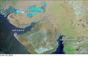
—the world's earliest known, connected the city to an ancient course of the Sabarmati river on the trade route between Harappa
n cities in Sindh
and the peninsula of Saurashtra when the surrounding Kutch desert of today was a part of the Arabian Sea
.It was a vital and thriving trade center in ancient times, with its trade of bead
s, gems
and valuable ornaments reaching the far corners of West Asia and Africa
. The techniques and tools they pioneered for bead-making and in metallurgy
have stood the test of time for over 4000 years.
Lothal is situated near the village of Saragwala in the Dholka
taluka of Ahmedabad district. It is six kilometers (south-east) of the Lothal-Bhurkhi railway station on the Ahmedabad
-Bhavnagar
railway line. It is also connected by all-weather roads to the cities of Ahmedabad (85 km/53 mi), Bhavnagar, Rajkot and Dholka. The nearest cities are Dholka and Bagodara. Resuming excavation in 1961, archaeologists unearthed trenches sunk on the northern, eastern and western flanks of the mound, bringing to light the inlet channels and nullah ("ravine", or "gully") connecting the dock with the river. The findings consist of a mound
, a township
, a marketplace
, and the dock. Adjacent to the excavated areas stands the Archaeological Museum, where some of the most prominent collections of Indus-era antiquities in India are displayed.
 The meaning of Lothal (a combination of Loth and (s) thal) in Gujarati
to be "the mound of the dead" is not unusual, as the name of the city of Mohenjo-daro
in Sindhi
means the same. People in villages neighboring to Lothal had known of the presence of an ancient town and human remains. As recently as 1850, boats could sail up to the mound. In 1942, timber was shipped from Broach
to Saragwala via the mound. A silted creek connecting modern Bholad with Lothal and Saragwala represents the ancient flow channel of a river or creek. When India was partitioned
in 1947, most Indus sites, including Mohenjo-daro
and Harappa
, became part of Pakistan
. The Archaeological Survey of India undertook a new program of exploration, and excavation. Many sites were discovered across northwestern India. Between 1954 and 1958, more than 50 sites were excavated in the Kutch {see also Dholavira
}, and Saurashtra peninsulas, extending the limits of Harappan civilization by 500 kilometres (310 mi) to the river Kim, where the Bhagatrav
site accesses the valley of the rivers Narmada
and Tapti. Lothal stands 270 kilometers (170 mi) from Mohenjo-daro
, which is in Sindh
. Speculation suggests that owing to the comparatively small dimensions of the main city, Lothal was not a large settlement at all, and its "dock" was perhaps an irrigation tank. However, the ASI and other contemporary archaeologists assert that the city was a part of a major river system on the trade route of the ancient peoples from Sindh to Saurashtra in Gujarat. Cemeteries have been found which indicate that its people were probably of Dravidian, Proto-Australoid
or Mediterranean physiques. Lothal provides with the largest collection of antiquities in the archaeology of modern India. It is essentially a single culture site—the Harappan culture in all its variances is evidenced. An indigenous micaceous Red Ware culture also existed, which is believed to be autochthonous
and pre-Harappan. Two sub-periods of Harappan culture are distinguished: the same period (between 2400 and 1900 BCE) is identical to the exuberant culture of Harappa
and Mohenjo-daro
.
 After the core of the Indus
civilization had decayed in Mohenjo-daro
and Harappa
, Lothal seems not only to have survived, but to have thrived for many years. Its constant threats, tropical storms and floods, caused immense destruction, which destabilized the culture and ultimately caused its end. Topographical analysis
also shows signs that at about the time of its demise, the region suffered from aridity or weakened monsoon
rainfall. Thus the cause for the abandonment of the city may have been changes in the climate
as well as natural disasters, as suggested by environmental magnetic records. Lothal is based upon a mound that was a salt marsh
inundated by tide. Remote sensing and topographical studies published by Indian scientists in the Journal of the Indian Geophysicists Union in 2004 revealed an ancient, meandering river adjacent to Lothal, 30 kilometres (19 mi) in length according to satellite imagery
—an ancient extension of the northern river channel bed of a tributary of the Bhogavo river. Small channel widths (10–300 m/30–1000 ft) when compared to the lower reaches (1.2–1.6 km/0.75–1.0 mi) suggest the presence of a strong tidal influence upon the city—tidal waters ingressed up to and beyond the city. Upstream elements of this river provided a suitable source of freshwater
for the inhabitants.
n people (c. 2400 BCE), Lothal was a small village next to the river providing access to the mainland from the Gulf of Khambhat
. The indigenous peoples maintained a prosperous economy, attested by the discovery of copper objects, beads and semi-precious stones. Ceramic wares were of fine clay and smooth, mica
ceous red surface. A new technique of firing pottery
under partly oxidizing and reducing conditions was improved by them—designated black-and-red ware, to the micaceous Red Ware. Harappans were attracted to Lothal for its sheltered harbor, rich cotton and rice-growing environment and bead-making industry. The beads and gems of Lothal were in great demand in the west. The settlers lived peacefully with the Red Ware people, who adopted their lifestyle, evidenced from the flourishing trade and changing working techniques. Harappans began producing the indigenous ceramic goods, adopting the manner from the natives.
, or acropolis
and a lower town. The rulers of the town lived in the acropolis, which featured paved baths
, underground and surface drains (built of kiln-fired bricks) and a potable water well. The lower town was subdivided into two sectors. A north-south arterial street was the main commercial area. It was flanked by shops of rich and ordinary merchants and craftsmen. The residential area was located to either side of the marketplace. The lower town was also periodically enlarged during Lothal's years of prosperity.
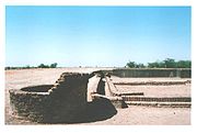
Lothal engineers accorded high priority to the creation of a dockyard and a warehouse
to serve the purposes of naval trade. While the consensus view amongst archaeologists identifies this structure as a "dockyard," it has also been suggested that owing to small dimensions, this basin may have been an irrigation tank and canal. The dock was built on the eastern flank of the town, and is regarded by archaeologists as an engineering feat of the highest order. It was located away from the main current of the river to avoid silting, but provided access to ships in high tide as well. The warehouse was built close to the acropolis on a 3.5-meter-high (10.5 ft) podium of mud bricks. The rulers could thus supervise the activity on the dock and warehouse simultaneously. Facilitating the movement of cargo was a mud-brick wharf
, 220 metres (720 ft) long, built on the western arm of the dock, with a ramp leading to the warehouse. There was an important public building opposite to the warehouse whose superstructure has completely disappeared. Throughout their time, the city had to brace itself through multiple floods and storms. Dock and city peripheral walls were maintained efficiently. The town's zealous rebuilding ensured the growth and prosperity of the trade. However, with rising prosperity, Lothal's people failed to upkeep their walls and dock facilities, possibly as a result of over-confidence in their systems. A flood of moderate intensity in 2050 BCE exposed some serious weaknesses in the structure, but the problems were not addressed properly.
 The uniform organization of the town and its institutions give evidence that the Harappans were a very disciplined people. Commerce and administrative duties were performed according to standards laid out. Municipal administration was strict — the width of most streets remained the same over a long time, and no encroached structures were built. Householders possessed a sump
, or collection chamber to deposit solid waste in order to prevent the clogging of city drains. Drains, manholes and cesspools kept the city clean and deposited the waste in the river, which was washed out during high tide. A new provincial style of Harappan art and painting was pioneered. The new approaches included realistic portrayals of animals in their natural surroundings. Metalware, gold and jewelery and tastefully decorated ornaments attest to the culture and prosperity of the people of Lothal.
Most of their equipment: metal tools, weights, measures, seals, earthenware and ornaments were of the uniform standard and quality found across the Indus civilization. Lothal was a major trade center, importing en masse raw materials like copper
, chert
and semi-precious stones from Mohenjo-daro
and Harappa
, and mass distributing to inner villages and towns. It also produced large quantities of bronze celts
, fish-hooks, chisels, spears and ornaments. Lothal exported its beads, gemstones, ivory and shells. The stone blade industry catered to domestic needs—fine chert was imported from the Sukkur
valley or from Bijapur
in modern Karnataka
. Bhagatrav
supplied semi-precious stones while chank shell came from Dholavira
and Bet Dwarka
. An intensive trade network gave the inhabitants great prosperity. The network stretched across the frontiers to Egypt
, Bahrain
and Sumer
. One of the evidence of trade in Lothal is the discovery of typical Persian gulf seals, a circular button seal
continues, archaeological evidence gathered by the ASI appears to point to natural catastrophes, specifically floods and storms as the source of Lothal's downfall. A powerful flood submerged the town and destroyed most of the houses, with the walls and platforms heavily damaged. The acropolis and was leveled (2000-1900 BCE), and inhabited by common tradesmen and newly built makeshift houses. The worst consequence was the shift in the course of the river, cutting off access to the ships and dock. The people built a new but shallow inlet to connect the flow channel to the dock for sluicing small ships into the basin. Large ships were moored away. Houses were rebuilt, yet without removal of flood debris, which made them poor-quality and susceptible to further damage. Public drains were replaced by soakage jars. The citizens did not undertake encroachments, and rebuilt public baths. However, with a poorly organized government, and no outside agency or central government, the public works could not be properly repaired or maintained. The heavily damaged warehouse was never repaired properly, and stocks were stored in wooden canopies, exposed to floods and fire. The economy of the city was transformed. Trade volumes reduced greatly, though not catastrophically, and resources were available in lesser quantities. Independent businesses caved, allowing a merchant-centric system of factories to develop where hundreds of craftsmen worked for the same supplier and financier. The bead factory had ten living rooms and a large workplace courtyard. The coppersmith's workshop had five furnaces and paved sinks to enable multiple artisans to work.
The declining prosperity of the town, paucity of resources and poor administration increased the woes of a people pressured by consistent floods and storms. Increased salinity of soil made the land inhospitable to life, including crops. This is evidenced in adjacent cities of Rangpur
, Rojdi
, Rupar and Harappa in Punjab
, Mohenjo-daro
and Chanhudaro
in Sindh
. A massive flood (c. 1900 BCE) completely destroyed the flagging township in a single stroke. Archaeological analysis shows that the basin and dock were sealed with silt and debris, and the buildings razed to the ground. The flood affected the entire region of Saurashtra, Sindh and south Gujarat, and affected the upper reaches of the Indus
and Sutlej
, where scores of villages and townships were washed away. The population fled to inner regions.
 Archaeological evidence shows that the site continued to be inhabited, albeit by a much smaller population devoid of urban influences. The few people who returned to Lothal could not reconstruct and repair their city, but surprisingly continued to stay and preserved religious traditions, living in poorly built houses and reed huts. That they were the Harappan peoples is evidenced by the analyses of their remains in the cemetery. While the trade and resources of the city were almost entirely gone, the people retained several Harappan ways in writing, pottery and utensils. About this time ASI archaeologists record a mass movement of refugees from Punjab and Sindh into Saurashtra and to the valley of Sarasvati
(1900-1700 BCE). Hundreds of ill-equipped settlements have been attributed to this people as Late Harappans
a completely de-urbanised culture characterized by rising illiteracy, less complex economy, unsophisticated administration and poverty. Though Indus seals went out of use, the system of weights with an 8.573 gram
(0.3024 oz avoirdupois
) unit was retained. Between 1700 and 1600 BCE, trade would revive again. In Lothal, Harappan ceramic works of bowls, dishes and jars were mass-produced. Merchants used local materials such as chalcedony
instead of chert
for stone blades. Truncated sandstone weights replaced hexahedron chert weights. The sophisticated painting style reduced itself to wavy lines, loops and fronds.
, architecture
, science
, engineering
and religion
. Their work in metallurgy
, seals
, beads and jewelery was the basis of their prosperity.
to measure angles on plane surfaces or in the horizon in multiples of 40 degrees, up to 360 degrees. Such shell instruments were probably invented to measure 8–12 whole sections of the horizon and sky, explaining the slits on the lower and upper margins. Archaeologists consider this as evidence that the Lothal experts had achieved something 2,000 years before the Greeks: an 8–12 fold division of horizon and sky, as well as an instrument for measuring angles and perhaps the position of stars, and for navigation. Lothal contributes one of three measurement scales that are integrated and linear (others found in Harappa and Mohenjodaro). An ivory scale from Lothal has the smallest-known decimal divisions in Indus civilization. The scale is 6 millimetres (0.2 inches) thick, 15 mm (0.6 inches) broad and the available length is 128 mm (5.0 inches), but only 27 graduations are visible over 46 mm (1.8 inches), the distance between graduation lines being 1.70 mm (0.067 inches) (the small size indicates use for fine purposes). The sum total of ten graduations from Lothal is approximate to the angula in the Arthashastra
. The Lothal craftsmen took care to ensure durability and accuracy of stone weights by blunting edges before polishing.
For their renowned draining system, Lothal engineers provided corbel
led roofs, and an apron of kiln-fired bricks over the brick face of the platform where the sewerage entered the cesspool. Wooden screens inserted in grooves in the side drain walls held back solid waste. The well is built of radial bricks, 2.4 metres (7.9 ft) in diameter and 6.7 metres (22 ft) deep. It had an immaculate network of underground drains, silting chambers and cesspools, and inspection chambers for solid waste. The extent of drains provided archaeologists with many clues regarding the layout of streets, organization of housing and baths. On average, the main sewer is 20–46 cm (7.8–18.1 inches) in depth, with outer dimensions of 86 × 68 × 33 cm (34 × 27 × 13 in). Lothal brick-makers used a logical approach in manufacture of bricks, designed with care in regards to thickness of structures. They were used as headers and stretchers in same and alternate layers. Archaeologists estimate that in most cases, the bricks were in ratio 1:0.5:0.25 on three sides, in dimensions which were integral multiples of large graduations of Lothal scale of 25 mm (1.0 in).
. Animal worship is also evidenced, but not the worship of the Mother Goddess
that is evidenced in other Harappa
n cities—experts consider this a sign of the existence of diversity in religious traditions. However, it is believed that a sea goddess, perhaps cognate with the general Indus-era Mother Goddess, was worshiped. Today, the local villagers likewise worship a sea goddess, Vanuvati Sikotarimata, suggesting a connection with the ancient port's traditions and historical past as an access to the sea. But the archaeologists also discovered that the practice had been given up by 2000 BCE (determined by the difference in burial times of the carbon-dated remains). It is suggested that the practice occurred only on occasion. It is also considered that given the small number of graves discovered—only 17 in an estimated population of 15,000—the citizens of Lothal also practiced cremation
of the dead. Post-cremation burials have been noted in other Indus sites like Harappa, Mehi and Damb-Bhuti.
 Lothal copper is unusually pure, lacking the arsenic
typically used by coppersmiths across the rest of the Indus valley. The city imported ingot
s from probable sources in the Arabian peninsula. Workers mixed tin with copper for the manufacture of celts
, arrowheads, fishhooks, chisels, bangles, rings, drills and spearheads, although weapon manufacturing was minor. They also employed advanced metallurgy in following the cire perdue technique of casting, and used more than one-piece molds for casting birds and animals. They also invented new tools such as curved saws and twisted drills unknown to other civilizations at the time.
Lothal was one of the most important centers of production for shell-working, owing to the abundance of chank shell of high quality found in the Gulf of Kutch
and near the Kathiawar
coast Gamesmen, beads, unguent
vessels, chank shells, ladles and inlays were made for export and local consumption. Components of stringed musical instruments like the plectrum
and the bridge
were made of shell. An ivory workshop was operated under strict official supervision, and the domestication of elephants has been suggested. An ivory seal, and sawn pieces for boxes, combs, rods, inlays and ear-studs were found during excavations. Lothal produced a large quantity of gold ornaments—the most attractive item being microbeads of gold in five strands in necklaces, unique for being less than 0.25 millimetres (0.010 inches) in diameter. Cylindrical, globular and jasper beads of gold with edges at right angles resemble modern pendants used by women in Gujarat in plaits of hair. A large disc with holes recovered from a sacrificial altar is compared to the rukma worn by Vedic priests. Studs, cogwheel and heart-shaped ornaments of fainence and steatite were popular in Lothal. A ring of thin copper wire turned into double spirals resembles the gold-wire rings used by modern Hindus for weddings.
 The discovery of etched carnelian
beads and non-etched barrel beads in Kish
and Ur
(modern Iraq
), Jalalabad
(Afghanistan
) and Susa
(Iran
) attest to the popularity of the Indus bead industry across West Asia. The lapidaries
select stones of variegated colors, producing beads of different shapes and sizes. The methods of Lothal bead-makers were so advanced that no improvements have been noted over 4,000 years—modern makers in the Khambhat
area follow the same technique. Double-eye beads of agate
and collared or gold-capped beads of jasper
and carnelian beads are among those attributed as uniquely from Lothal. It was very famous for micro-cylindrical beads of steatite (chlorite).
The Lothal excavation yielded 213 seals, third in volume amongst all Indus sites. Seal-cutters preferred short-horned bulls, mountain goats, tigers and composite animals like the elephant-bull for engravings. There is a short inscription of intaglio in almost every seal. Stamp seals with copper rings inserted in a perforated button were used to sealing cargo, with impressions of packing materials like mats, twisted cloth and cords, a fact verified only at Lothal. Quantitative descriptions, seals of rulers and owners were stamped on goods. A unique seal found here is from Bahrain
—circular, with motif of a dragon flanked by jumping gazelles.
Lothal offers two new types of potter work, a convex bowl with or without stud handle, and a small jar with flaring rim, both in the mica
ceous Red Ware period, not found in contemporary Indus cultures. Lothal artists introduced a new form of realistic painting. Paintings depict animals in their natural surroundings. On one large vessel, the artist depicts birds with fish in their beaks, resting in a tree, while a fox-like animal stands below. This scene bears resemblance to the story of The Fox and the Crow
in the Panchatantra
. Artistic imagination is also suggested via careful portrayals—for example, several birds with legs aloft in the sky suggest flight, while half-opened wings suggest imminent flight. On a miniature jar, the story of the thirsty crow and deer is depicted — of how the deer could not drink from the narrow-mouth of the jar, while the crow succeeded by dropping stones in the jar. The features of the animals are clear and graceful. Movements and emotions are suggested by the positioning of limbs and facial features—in a 15 × 5 cm (6 × 2 in) jar without overcrowding.
A complete set of terra-cotta gamesmen, has been found in Lothal—animal figures, pyramids with ivory handles and castle-like objects (similar to the chess set of Queen Hatshepsut
in Egypt). The realistic portrayal of human beings and animals suggests a careful study of anatomical and natural features. The bust of a male with slit eyes, sharp nose and square-cut beard is reminiscent of Sumer
ian figures, especially stone sculptures from Mari
. In images of men and women, muscular and physical features are sharp, prominently marked. Terra-cotta models also identify the differences between species of dogs and bulls, including those of horses. Animal figures with wheels and a movable head may have been utilized as toys.
 On plan, Lothal stands 285 metres (935 ft) north-to-south and 228 metres (748 ft) east-to-west. At the height of its habitation, it covered a wider area since remains have been found 300 metres (1000 ft) south of the mound. Due to the fragile nature of unbaked bricks and frequent floods, the superstructures of all buildings have receded. Dwarfed walls, platforms, wells, drains, baths and paved floors are visible. But thanks to the loam
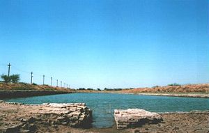
deposited by persistent floods, the dock walls were preserved beyond the great deluge (c. 1900 BCE). The absence of standing high walls is attributed to erosion and brick robbery. The ancient nullah, the inlet channel and riverbed have been similarly covered up. The flood-damaged peripheral wall of mud-bricks is visible near the warehouse area. The remnants of the north-south sewer are burnt bricks in the cesspool. Cubical blocks of the warehouse on a high platform are also visible.
The ASI has covered the peripheral walls, the wharf and many houses of the early phase with earth to protect from natural phenomena, but the entire archaeological site is nevertheless facing grave concerns about necessary preservation. Salinity
ingress and prolonged exposure to the rain and sun are gradually eating away the remains of the site. Heavy rain in the region has damaged the remains of the sun-dried mud brick constructions. Stagnant rain water has lathered the brick and mud work with layers of moss. Due to silt
ation, the dockyard’s draft has been reduced by 3–4 metres (10–13 ft) and saline deposits are decaying the bricks. Officials blame the salinity on capillary action
and point out that cracks are emerging and foundations weakening even as restoration work slowly progresses.
and maritime engineering. This was the earliest known dock found in the world, equipped to berth and service ships. It is speculated that Lothal engineers studied tidal movements, and their effects on brick-built structures, since the walls are of kiln-burnt bricks. This knowledge also enabled them to select Lothal's location in the first place, as the Gulf of Khambhat
has the highest tidal amplitude and ships can be sluiced through flow tides in the river estuary. The engineers built a trapezoidal structure, with north-south arms of average 21.8 metres (71.5 ft), and east-west arms of 37 metres (121 ft). Another assessment is that the basin could have served as an irrigation tank, for the estimated original dimensions of the "dock" are not large enough, by modern standards, to house ships and conduct much traffic.
The original height of the embankments was 4.26 metres (13.98 ft). (Now it is 3.35 metres (10.99 ft).) The main inlet is 12.8 metres (42.0 ft) wide, and another is provided on the opposite side. To counter the thrust of water, offsets were provided on the outer wall faces. When the river changed its course in 2000 BCE, a smaller inlet, 7 metres (23 ft) wide was made in the longer arm, connected to the river by a 2 kilometre (3.2 mi) channel. At high tide a flow of 2.1–2.4 metres (6.9–7.9 ft) of water would have allowed ships to enter. Provision was made for the escape of excess water through the outlet channel, 96.5 metres (317 ft) wide and 1.7 metres (5.6 ft) high in the southern arm. The dock also possessed a lock-gate system—a wooden door could be lowered at the mouth of the outlet to retain a minimum column of water in the basin so as to ensure floatation at low tides. Central to the city's economy, the warehouse was originally built on sixty-four cubical blocks, 3.6 metres (11.8 ft) square, with 1.2-metre (3.9-ft) passages, and based on a 3.5-metre-high (11.5 ft) mud-brick podium. The pedestal was very high to provide maximum protection from floods. Brick-paved passages between blocks served as vent
s, and a direct ramp led to the dock to facilitate loading. The warehouse was located close to the acropolis, to allow tight supervision by ruling authorities. Despite elaborate precautions, the major floods that brought the city's decline destroyed all but twelve blocks, which became the make-shift storehouse.
The bead factory, which performs a very important economic function, possesses a central courtyard and eleven rooms, a store and a guardhouse. There is a cinder dump, as well as a double-chambered circular kiln, with stoke-holes for fuel supply. Four flue
s are connected with each other, the upper chamber and the stoke hold. The mud plaster of the floors and walls are vitrified owing to intense heat during work. The remnants of raw materials such as reed, cow dung, sawdust and agate are found, giving archaeologists hints of how the kiln was operated. A large mud-brick building faces the factory, and its significance is noted by its plan. Four large rooms and a hall, with an overall measurement of 17.1 × 12.8 metres (56 × 42 ft). The hall has a large doorway and a raised floor in the southern corner of the building.
Indus Valley Civilization
The Indus Valley Civilization was a Bronze Age civilization that was located in the northwestern region of the Indian subcontinent, consisting of what is now mainly modern-day Pakistan and northwest India...
. Located in Bhāl region
Bhal region
Bhāl region is spread across political boundaries of two districts of the Indian state of Gujarat, namely Bhavnagar district and Ahmedabad district . The word Bhaal seems to have been derived from the Sanskrit word भाल which means forehead...
of the modern state of Gujarāt and dating from 2400 BCE. Discovered in 1954, Lothal was excavated from February 13, 1955 to May 19, 1960 by the Archaeological Survey of India
Archaeological Survey of India
The Archaeological Survey of India is a department of the Government of India, attached to the Ministry of Culture . The ASI is responsible for archaeological studies and the preservation of archaeological heritage of the country in accordance with the various acts of the Indian Parliament...
(ASI). Lothal's dock
Dock (maritime)
A dock is a human-made structure or group of structures involved in the handling of boats or ships, usually on or close to a shore.However, the exact meaning varies among different variants of the English language...
—the world's earliest known, connected the city to an ancient course of the Sabarmati river on the trade route between Harappa
Harappa
Harappa is an archaeological site in Punjab, northeast Pakistan, about west of Sahiwal. The site takes its name from a modern village located near the former course of the Ravi River. The current village of Harappa is from the ancient site. Although modern Harappa has a train station left from...
n cities in Sindh
Sindh
Sindh historically referred to as Ba'ab-ul-Islam , is one of the four provinces of Pakistan and historically is home to the Sindhi people. It is also locally known as the "Mehran". Though Muslims form the largest religious group in Sindh, a good number of Christians, Zoroastrians and Hindus can...
and the peninsula of Saurashtra when the surrounding Kutch desert of today was a part of the Arabian Sea
Arabian Sea
The Arabian Sea is a region of the Indian Ocean bounded on the east by India, on the north by Pakistan and Iran, on the west by the Arabian Peninsula, on the south, approximately, by a line between Cape Guardafui in northeastern Somalia and Kanyakumari in India...
.It was a vital and thriving trade center in ancient times, with its trade of bead
Bead
A bead is a small, decorative object that is usually pierced for threading or stringing. Beads range in size from under to over in diameter. A pair of beads made from Nassarius sea snail shells, approximately 100,000 years old, are thought to be the earliest known examples of jewellery. Beadwork...
s, gems
Gemstone
A gemstone or gem is a piece of mineral, which, in cut and polished form, is used to make jewelry or other adornments...
and valuable ornaments reaching the far corners of West Asia and Africa
Africa
Africa is the world's second largest and second most populous continent, after Asia. At about 30.2 million km² including adjacent islands, it covers 6% of the Earth's total surface area and 20.4% of the total land area...
. The techniques and tools they pioneered for bead-making and in metallurgy
Metallurgy
Metallurgy is a domain of materials science that studies the physical and chemical behavior of metallic elements, their intermetallic compounds, and their mixtures, which are called alloys. It is also the technology of metals: the way in which science is applied to their practical use...
have stood the test of time for over 4000 years.
Lothal is situated near the village of Saragwala in the Dholka
Dholka
Dholka is a city and municipality in the Ahmedabad District of the Indian state of Gujarat. With an average elevation of , Dholka is considered "India's first municipality".-History:...
taluka of Ahmedabad district. It is six kilometers (south-east) of the Lothal-Bhurkhi railway station on the Ahmedabad
Ahmedabad
Ahmedabad also known as Karnavati is the largest city in Gujarat, India. It is the former capital of Gujarat and is also the judicial capital of Gujarat as the Gujarat High Court has its seat in Ahmedabad...
-Bhavnagar
Bhavnagar
-Topography:Bhavnagar is a coastal city in the eastern coast of Saurashtra, also known as Kathiawar, located at . It has an average elevation of 24 metres . It occupies area of 53.30 km². General slope dips in the northeasterly direction at the apex of Gulf of Khambhat...
railway line. It is also connected by all-weather roads to the cities of Ahmedabad (85 km/53 mi), Bhavnagar, Rajkot and Dholka. The nearest cities are Dholka and Bagodara. Resuming excavation in 1961, archaeologists unearthed trenches sunk on the northern, eastern and western flanks of the mound, bringing to light the inlet channels and nullah ("ravine", or "gully") connecting the dock with the river. The findings consist of a mound
Mound
A mound is a general term for an artificial heaped pile of earth, gravel, sand, rocks, or debris. The most common use is in reference to natural earthen formation such as hills and mountains, particularly if they appear artificial. The term may also be applied to any rounded area of topographically...
, a township
Township
The word township is used to refer to different kinds of settlements in different countries. Township is generally associated with an urban area. However there are many exceptions to this rule. In Australia, the United States, and Canada, they may be settlements too small to be considered urban...
, a marketplace
Marketplace
A marketplace is the space, actual, virtual or metaphorical, in which a market operates. The term is also used in a trademark law context to denote the actual consumer environment, ie. the 'real world' in which products and services are provided and consumed.-Marketplaces and street markets:A...
, and the dock. Adjacent to the excavated areas stands the Archaeological Museum, where some of the most prominent collections of Indus-era antiquities in India are displayed.
Archaeology
Gujarati language
Gujarati is an Indo-Aryan language, and part of the greater Indo-European language family. It is derived from a language called Old Gujarati which is the ancestor language of the modern Gujarati and Rajasthani languages...
to be "the mound of the dead" is not unusual, as the name of the city of Mohenjo-daro
Mohenjo-daro
Mohenjo-daro is an archeological site situated in what is now the province of Sindh, Pakistan. Built around 2600 BC, it was one of the largest settlements of the ancient Indus Valley Civilization, and one of the world's earliest major urban settlements, existing at the same time as the...
in Sindhi
Sindhi language
Sindhi is the language of the Sindh region of Pakistan that is spoken by the Sindhi people. In India, it is among 22 constitutionally recognized languages, where Sindhis are a sizeable minority. It is spoken by 53,410,910 people in Pakistan, according to the national government's Statistics Division...
means the same. People in villages neighboring to Lothal had known of the presence of an ancient town and human remains. As recently as 1850, boats could sail up to the mound. In 1942, timber was shipped from Broach
Bharuch
Bharuch , also known as Broach, is the oldest city in Gujarat, situated at the mouth of the holy river Narmada. Bharuch is the administrative headquarters of Bharuch District and a municipality of more than 1,50,000 inhabitants. As Bharuch is a major seaport city, a number of trade activities have...
to Saragwala via the mound. A silted creek connecting modern Bholad with Lothal and Saragwala represents the ancient flow channel of a river or creek. When India was partitioned
Partition of India
The Partition of India was the partition of British India on the basis of religious demographics that led to the creation of the sovereign states of the Dominion of Pakistan and the Union of India on 14 and 15...
in 1947, most Indus sites, including Mohenjo-daro
Mohenjo-daro
Mohenjo-daro is an archeological site situated in what is now the province of Sindh, Pakistan. Built around 2600 BC, it was one of the largest settlements of the ancient Indus Valley Civilization, and one of the world's earliest major urban settlements, existing at the same time as the...
and Harappa
Harappa
Harappa is an archaeological site in Punjab, northeast Pakistan, about west of Sahiwal. The site takes its name from a modern village located near the former course of the Ravi River. The current village of Harappa is from the ancient site. Although modern Harappa has a train station left from...
, became part of Pakistan
Pakistan
Pakistan , officially the Islamic Republic of Pakistan is a sovereign state in South Asia. It has a coastline along the Arabian Sea and the Gulf of Oman in the south and is bordered by Afghanistan and Iran in the west, India in the east and China in the far northeast. In the north, Tajikistan...
. The Archaeological Survey of India undertook a new program of exploration, and excavation. Many sites were discovered across northwestern India. Between 1954 and 1958, more than 50 sites were excavated in the Kutch {see also Dholavira
Dholavira
Dholavira is an archaeological site in Khadirbet in Bhachau Taluka of Kachchh district of Gujarat state in western India, which has taken its name from a modern village 1 km south of it. The site of Dholavira, locally known as Kotada timba contains ruins of an ancient Harappan city...
}, and Saurashtra peninsulas, extending the limits of Harappan civilization by 500 kilometres (310 mi) to the river Kim, where the Bhagatrav
Bhagatrav
Bhagatrav is a minor archaeological site belonging to the Indus valley civilization. Excavated by the Archaeological Survey of India led by Dr. S. R...
site accesses the valley of the rivers Narmada
Narmada River
The Narmada , also called Rewa is a river in central India and the fifth largest river in the Indian subcontinent. It is the third largest river that completely flows within India after Ganges and Godavari...
and Tapti. Lothal stands 270 kilometers (170 mi) from Mohenjo-daro
Mohenjo-daro
Mohenjo-daro is an archeological site situated in what is now the province of Sindh, Pakistan. Built around 2600 BC, it was one of the largest settlements of the ancient Indus Valley Civilization, and one of the world's earliest major urban settlements, existing at the same time as the...
, which is in Sindh
Sindh
Sindh historically referred to as Ba'ab-ul-Islam , is one of the four provinces of Pakistan and historically is home to the Sindhi people. It is also locally known as the "Mehran". Though Muslims form the largest religious group in Sindh, a good number of Christians, Zoroastrians and Hindus can...
. Speculation suggests that owing to the comparatively small dimensions of the main city, Lothal was not a large settlement at all, and its "dock" was perhaps an irrigation tank. However, the ASI and other contemporary archaeologists assert that the city was a part of a major river system on the trade route of the ancient peoples from Sindh to Saurashtra in Gujarat. Cemeteries have been found which indicate that its people were probably of Dravidian, Proto-Australoid
Proto-Australoid
The Proto-Australoids are a hypothesized group of ancient hunter-gather people descended from the first major wave of modern humans to leave sub-Saharan Africa ~100,000 years ago...
or Mediterranean physiques. Lothal provides with the largest collection of antiquities in the archaeology of modern India. It is essentially a single culture site—the Harappan culture in all its variances is evidenced. An indigenous micaceous Red Ware culture also existed, which is believed to be autochthonous
Indigenous peoples
Indigenous peoples are ethnic groups that are defined as indigenous according to one of the various definitions of the term, there is no universally accepted definition but most of which carry connotations of being the "original inhabitants" of a territory....
and pre-Harappan. Two sub-periods of Harappan culture are distinguished: the same period (between 2400 and 1900 BCE) is identical to the exuberant culture of Harappa
Harappa
Harappa is an archaeological site in Punjab, northeast Pakistan, about west of Sahiwal. The site takes its name from a modern village located near the former course of the Ravi River. The current village of Harappa is from the ancient site. Although modern Harappa has a train station left from...
and Mohenjo-daro
Mohenjo-daro
Mohenjo-daro is an archeological site situated in what is now the province of Sindh, Pakistan. Built around 2600 BC, it was one of the largest settlements of the ancient Indus Valley Civilization, and one of the world's earliest major urban settlements, existing at the same time as the...
.
Indus Valley Civilization
The Indus Valley Civilization was a Bronze Age civilization that was located in the northwestern region of the Indian subcontinent, consisting of what is now mainly modern-day Pakistan and northwest India...
civilization had decayed in Mohenjo-daro
Mohenjo-daro
Mohenjo-daro is an archeological site situated in what is now the province of Sindh, Pakistan. Built around 2600 BC, it was one of the largest settlements of the ancient Indus Valley Civilization, and one of the world's earliest major urban settlements, existing at the same time as the...
and Harappa
Harappa
Harappa is an archaeological site in Punjab, northeast Pakistan, about west of Sahiwal. The site takes its name from a modern village located near the former course of the Ravi River. The current village of Harappa is from the ancient site. Although modern Harappa has a train station left from...
, Lothal seems not only to have survived, but to have thrived for many years. Its constant threats, tropical storms and floods, caused immense destruction, which destabilized the culture and ultimately caused its end. Topographical analysis
Topography
Topography is the study of Earth's surface shape and features or those ofplanets, moons, and asteroids...
also shows signs that at about the time of its demise, the region suffered from aridity or weakened monsoon
Monsoon
Monsoon is traditionally defined as a seasonal reversing wind accompanied by corresponding changes in precipitation, but is now used to describe seasonal changes in atmospheric circulation and precipitation associated with the asymmetric heating of land and sea...
rainfall. Thus the cause for the abandonment of the city may have been changes in the climate
Climate
Climate encompasses the statistics of temperature, humidity, atmospheric pressure, wind, rainfall, atmospheric particle count and other meteorological elemental measurements in a given region over long periods...
as well as natural disasters, as suggested by environmental magnetic records. Lothal is based upon a mound that was a salt marsh
Salt marsh
A salt marsh is an environment in the upper coastal intertidal zone between land and salt water or brackish water, it is dominated by dense stands of halophytic plants such as herbs, grasses, or low shrubs. These plants are terrestrial in origin and are essential to the stability of the salt marsh...
inundated by tide. Remote sensing and topographical studies published by Indian scientists in the Journal of the Indian Geophysicists Union in 2004 revealed an ancient, meandering river adjacent to Lothal, 30 kilometres (19 mi) in length according to satellite imagery
Satellite imagery
Satellite imagery consists of photographs of Earth or other planets made by means of artificial satellites.- History :The first images from space were taken on sub-orbital flights. The U.S-launched V-2 flight on October 24, 1946 took one image every 1.5 seconds...
—an ancient extension of the northern river channel bed of a tributary of the Bhogavo river. Small channel widths (10–300 m/30–1000 ft) when compared to the lower reaches (1.2–1.6 km/0.75–1.0 mi) suggest the presence of a strong tidal influence upon the city—tidal waters ingressed up to and beyond the city. Upstream elements of this river provided a suitable source of freshwater
Freshwater
Fresh water is naturally occurring water on the Earth's surface in ice sheets, ice caps, glaciers, bogs, ponds, lakes, rivers and streams, and underground as groundwater in aquifers and underground streams. Fresh water is generally characterized by having low concentrations of dissolved salts and...
for the inhabitants.
History
Before the arrival of HarappaHarappa
Harappa is an archaeological site in Punjab, northeast Pakistan, about west of Sahiwal. The site takes its name from a modern village located near the former course of the Ravi River. The current village of Harappa is from the ancient site. Although modern Harappa has a train station left from...
n people (c. 2400 BCE), Lothal was a small village next to the river providing access to the mainland from the Gulf of Khambhat
Gulf of Khambhat
The Gulf of Khambhat is an inlet of the Arabian Sea along the west coast of India, in the state of Gujarat. It is about 80 miles in length, and divides the Kathiawar peninsula to the west from the eastern part of Gujarat state on the east. The Narmada and Tapti rivers empty into the Gulf...
. The indigenous peoples maintained a prosperous economy, attested by the discovery of copper objects, beads and semi-precious stones. Ceramic wares were of fine clay and smooth, mica
Mica
The mica group of sheet silicate minerals includes several closely related materials having highly perfect basal cleavage. All are monoclinic, with a tendency towards pseudohexagonal crystals, and are similar in chemical composition...
ceous red surface. A new technique of firing pottery
Pottery
Pottery is the material from which the potteryware is made, of which major types include earthenware, stoneware and porcelain. The place where such wares are made is also called a pottery . Pottery also refers to the art or craft of the potter or the manufacture of pottery...
under partly oxidizing and reducing conditions was improved by them—designated black-and-red ware, to the micaceous Red Ware. Harappans were attracted to Lothal for its sheltered harbor, rich cotton and rice-growing environment and bead-making industry. The beads and gems of Lothal were in great demand in the west. The settlers lived peacefully with the Red Ware people, who adopted their lifestyle, evidenced from the flourishing trade and changing working techniques. Harappans began producing the indigenous ceramic goods, adopting the manner from the natives.
Town planning
A flood destroyed village foundations and settlements (c. 2350 BCE). Harappans based around Lothal and from Sindh took this opportunity to expand their settlement and create a planned township on the lines of greater cities in the Indus valley. Lothal planners engaged themselves to protect the area from consistent floods. The town was divided into blocks of 1–2-meter-high (3–6 ft) platforms of sun-dried bricks, each serving 20–30 houses of thick mud and brick walls. The city was divided into a citadelCitadel
A citadel is a fortress for protecting a town, sometimes incorporating a castle. The term derives from the same Latin root as the word "city", civis, meaning citizen....
, or acropolis
Acropolis
Acropolis means "high city" in Greek, literally city on the extremity and is usually translated into English as Citadel . For purposes of defense, early people naturally chose elevated ground to build a new settlement, frequently a hill with precipitous sides...
and a lower town. The rulers of the town lived in the acropolis, which featured paved baths
Public bathing
Public baths originated from a communal need for cleanliness. The term public may confuse some people, as some types of public baths are restricted depending on membership, gender, religious affiliation, or other reasons. As societies have changed, public baths have been replaced as private bathing...
, underground and surface drains (built of kiln-fired bricks) and a potable water well. The lower town was subdivided into two sectors. A north-south arterial street was the main commercial area. It was flanked by shops of rich and ordinary merchants and craftsmen. The residential area was located to either side of the marketplace. The lower town was also periodically enlarged during Lothal's years of prosperity.
Lothal engineers accorded high priority to the creation of a dockyard and a warehouse
Warehouse
A warehouse is a commercial building for storage of goods. Warehouses are used by manufacturers, importers, exporters, wholesalers, transport businesses, customs, etc. They are usually large plain buildings in industrial areas of cities and towns. They usually have loading docks to load and unload...
to serve the purposes of naval trade. While the consensus view amongst archaeologists identifies this structure as a "dockyard," it has also been suggested that owing to small dimensions, this basin may have been an irrigation tank and canal. The dock was built on the eastern flank of the town, and is regarded by archaeologists as an engineering feat of the highest order. It was located away from the main current of the river to avoid silting, but provided access to ships in high tide as well. The warehouse was built close to the acropolis on a 3.5-meter-high (10.5 ft) podium of mud bricks. The rulers could thus supervise the activity on the dock and warehouse simultaneously. Facilitating the movement of cargo was a mud-brick wharf
Wharf
A wharf or quay is a structure on the shore of a harbor where ships may dock to load and unload cargo or passengers.Such a structure includes one or more berths , and may also include piers, warehouses, or other facilities necessary for handling the ships.A wharf commonly comprises a fixed...
, 220 metres (720 ft) long, built on the western arm of the dock, with a ramp leading to the warehouse. There was an important public building opposite to the warehouse whose superstructure has completely disappeared. Throughout their time, the city had to brace itself through multiple floods and storms. Dock and city peripheral walls were maintained efficiently. The town's zealous rebuilding ensured the growth and prosperity of the trade. However, with rising prosperity, Lothal's people failed to upkeep their walls and dock facilities, possibly as a result of over-confidence in their systems. A flood of moderate intensity in 2050 BCE exposed some serious weaknesses in the structure, but the problems were not addressed properly.
Economy and urban culture
Sump
A sump is a low space that collects any often-undesirable liquids such as water or chemicals. A sump can also be an infiltration basin used to manage surface runoff water and recharge underground aquifers....
, or collection chamber to deposit solid waste in order to prevent the clogging of city drains. Drains, manholes and cesspools kept the city clean and deposited the waste in the river, which was washed out during high tide. A new provincial style of Harappan art and painting was pioneered. The new approaches included realistic portrayals of animals in their natural surroundings. Metalware, gold and jewelery and tastefully decorated ornaments attest to the culture and prosperity of the people of Lothal.
Most of their equipment: metal tools, weights, measures, seals, earthenware and ornaments were of the uniform standard and quality found across the Indus civilization. Lothal was a major trade center, importing en masse raw materials like copper
Copper
Copper is a chemical element with the symbol Cu and atomic number 29. It is a ductile metal with very high thermal and electrical conductivity. Pure copper is soft and malleable; an exposed surface has a reddish-orange tarnish...
, chert
Chert
Chert is a fine-grained silica-rich microcrystalline, cryptocrystalline or microfibrous sedimentary rock that may contain small fossils. It varies greatly in color , but most often manifests as gray, brown, grayish brown and light green to rusty red; its color is an expression of trace elements...
and semi-precious stones from Mohenjo-daro
Mohenjo-daro
Mohenjo-daro is an archeological site situated in what is now the province of Sindh, Pakistan. Built around 2600 BC, it was one of the largest settlements of the ancient Indus Valley Civilization, and one of the world's earliest major urban settlements, existing at the same time as the...
and Harappa
Harappa
Harappa is an archaeological site in Punjab, northeast Pakistan, about west of Sahiwal. The site takes its name from a modern village located near the former course of the Ravi River. The current village of Harappa is from the ancient site. Although modern Harappa has a train station left from...
, and mass distributing to inner villages and towns. It also produced large quantities of bronze celts
Celt (tool)
Celt is an archaeological term used to describe long thin prehistoric stone or bronze adzes, other axe-like tools, and hoes.-Etymology:The term "celt" came about from what was very probably a copyist's error in many medieval manuscript copies of Job 19:24 in the Latin Vulgate Bible, which became...
, fish-hooks, chisels, spears and ornaments. Lothal exported its beads, gemstones, ivory and shells. The stone blade industry catered to domestic needs—fine chert was imported from the Sukkur
Sukkur
Sukkur, or Sakharu , formerly Aror and Bakar, is the third largest city of Sindh province, situated on the west bank of Indus River in Pakistan in Sukkur District. However, the word Sakharu in Sindhi means "superior", which the spelling of the city's name in Sindhi suggests is the origin of the...
valley or from Bijapur
Bijapur, Karnataka
Bijapur Urdu:بیجاپور city is the district headquarters of Bijapur District of Karnataka state. Bijapur city is well known for its historical monuments of architectural importance built during the rule of Adil Shahi dynasty...
in modern Karnataka
Karnataka
Karnataka , the land of the Kannadigas, is a state in South West India. It was created on 1 November 1956, with the passing of the States Reorganisation Act and this day is annually celebrated as Karnataka Rajyotsava...
. Bhagatrav
Bhagatrav
Bhagatrav is a minor archaeological site belonging to the Indus valley civilization. Excavated by the Archaeological Survey of India led by Dr. S. R...
supplied semi-precious stones while chank shell came from Dholavira
Dholavira
Dholavira is an archaeological site in Khadirbet in Bhachau Taluka of Kachchh district of Gujarat state in western India, which has taken its name from a modern village 1 km south of it. The site of Dholavira, locally known as Kotada timba contains ruins of an ancient Harappan city...
and Bet Dwarka
Dwarka
Dwarka also spelled Dvarka, Dwaraka, and Dvaraka, is a city and a municipality of Jamnagar district in the Gujarat state in India. Dwarka , also known as Dwarawati in Sanskrit literature is rated as one of the seven most ancient cities in the country...
. An intensive trade network gave the inhabitants great prosperity. The network stretched across the frontiers to Egypt
Ancient Egypt
Ancient Egypt was an ancient civilization of Northeastern Africa, concentrated along the lower reaches of the Nile River in what is now the modern country of Egypt. Egyptian civilization coalesced around 3150 BC with the political unification of Upper and Lower Egypt under the first pharaoh...
, Bahrain
Bahrain
' , officially the Kingdom of Bahrain , is a small island state near the western shores of the Persian Gulf. It is ruled by the Al Khalifa royal family. The population in 2010 stood at 1,214,705, including 235,108 non-nationals. Formerly an emirate, Bahrain was declared a kingdom in 2002.Bahrain is...
and Sumer
Sumer
Sumer was a civilization and historical region in southern Mesopotamia, modern Iraq during the Chalcolithic and Early Bronze Age....
. One of the evidence of trade in Lothal is the discovery of typical Persian gulf seals, a circular button seal
Architectural Development
While the wider debate over the end of Indus civilizationIndus Valley Civilization
The Indus Valley Civilization was a Bronze Age civilization that was located in the northwestern region of the Indian subcontinent, consisting of what is now mainly modern-day Pakistan and northwest India...
continues, archaeological evidence gathered by the ASI appears to point to natural catastrophes, specifically floods and storms as the source of Lothal's downfall. A powerful flood submerged the town and destroyed most of the houses, with the walls and platforms heavily damaged. The acropolis and was leveled (2000-1900 BCE), and inhabited by common tradesmen and newly built makeshift houses. The worst consequence was the shift in the course of the river, cutting off access to the ships and dock. The people built a new but shallow inlet to connect the flow channel to the dock for sluicing small ships into the basin. Large ships were moored away. Houses were rebuilt, yet without removal of flood debris, which made them poor-quality and susceptible to further damage. Public drains were replaced by soakage jars. The citizens did not undertake encroachments, and rebuilt public baths. However, with a poorly organized government, and no outside agency or central government, the public works could not be properly repaired or maintained. The heavily damaged warehouse was never repaired properly, and stocks were stored in wooden canopies, exposed to floods and fire. The economy of the city was transformed. Trade volumes reduced greatly, though not catastrophically, and resources were available in lesser quantities. Independent businesses caved, allowing a merchant-centric system of factories to develop where hundreds of craftsmen worked for the same supplier and financier. The bead factory had ten living rooms and a large workplace courtyard. The coppersmith's workshop had five furnaces and paved sinks to enable multiple artisans to work.
The declining prosperity of the town, paucity of resources and poor administration increased the woes of a people pressured by consistent floods and storms. Increased salinity of soil made the land inhospitable to life, including crops. This is evidenced in adjacent cities of Rangpur
Rangpur, India
Rangpur is an archaeological site in Gujarat, India. Lying on the tip between the Gulf of Khambhat and Gulf of Kutch, it belongs to the period of the Indus valley civilization, and lies to the northwest of the larger site of Lothal. It was excavated by the Archaeological Survey of India, led by Dr....
, Rojdi
Rojdi
Rojdi is an archaeological site belonging to the Indus valley civilization. It is located on the northern bank of the Bhadar River in Gondal taluka of Rajkot district in central Saurashtra peninsula of Gujarat state in India...
, Rupar and Harappa in Punjab
Punjab region
The Punjab , also spelled Panjab |water]]s"), is a geographical region straddling the border between Pakistan and India which includes Punjab province in Pakistan and the states of the Punjab, Haryana, Himachal Pradesh, Chandigarh and some northern parts of the National Capital Territory of Delhi...
, Mohenjo-daro
Mohenjo-daro
Mohenjo-daro is an archeological site situated in what is now the province of Sindh, Pakistan. Built around 2600 BC, it was one of the largest settlements of the ancient Indus Valley Civilization, and one of the world's earliest major urban settlements, existing at the same time as the...
and Chanhudaro
Chanhudaro
-Introduction:Chanhudaro is an archaeological site belonging to the post-urban Jhukar phase of Indus valley civilization. The site is located south of Mohenjodaro, in Sindh, Pakistan. The settlement was inhabited between 4000-1700 BCE, and is considered to have been a centre for manufacturing...
in Sindh
Sindh
Sindh historically referred to as Ba'ab-ul-Islam , is one of the four provinces of Pakistan and historically is home to the Sindhi people. It is also locally known as the "Mehran". Though Muslims form the largest religious group in Sindh, a good number of Christians, Zoroastrians and Hindus can...
. A massive flood (c. 1900 BCE) completely destroyed the flagging township in a single stroke. Archaeological analysis shows that the basin and dock were sealed with silt and debris, and the buildings razed to the ground. The flood affected the entire region of Saurashtra, Sindh and south Gujarat, and affected the upper reaches of the Indus
Indus River
The Indus River is a major river which flows through Pakistan. It also has courses through China and India.Originating in the Tibetan plateau of western China in the vicinity of Lake Mansarovar in Tibet Autonomous Region, the river runs a course through the Ladakh district of Jammu and Kashmir and...
and Sutlej
Sutlej
The Sutlej River is the longest of the five rivers that flow through the historic crossroad region of Punjab in northern India and Pakistan. It is located north of the Vindhya Range, south of the Hindu Kush segment of the Himalayas, and east of the Central Sulaiman Range in Pakistan.The Sutlej...
, where scores of villages and townships were washed away. The population fled to inner regions.
Later Harappan culture
Sarasvati River
The Sarasvati River is one of the chief Rigvedic rivers mentioned in ancient Hindu texts. The Nadistuti hymn in the Rigveda mentions the Sarasvati between the Yamuna in the east and the Sutlej in the west, and later Vedic texts like Tandya and Jaiminiya Brahmanas as well as the Mahabharata...
(1900-1700 BCE). Hundreds of ill-equipped settlements have been attributed to this people as Late Harappans
Cemetery H culture
The Cemetery H culture developed out of the northern part of the Indus Valley Civilization around 1900 BCE, in and around western Punjab region located in present-day India and Pakistan...
a completely de-urbanised culture characterized by rising illiteracy, less complex economy, unsophisticated administration and poverty. Though Indus seals went out of use, the system of weights with an 8.573 gram
Gram
The gram is a metric system unit of mass....
(0.3024 oz avoirdupois
Avoirdupois
The avoirdupois system is a system of weights based on a pound of 16 ounces. It is the everyday system of weight used in the United States and is still widely used to varying degrees by many people in Canada, the United Kingdom, and some other former British colonies despite the official adoption...
) unit was retained. Between 1700 and 1600 BCE, trade would revive again. In Lothal, Harappan ceramic works of bowls, dishes and jars were mass-produced. Merchants used local materials such as chalcedony
Chalcedony
Chalcedony is a cryptocrystalline form of silica, composed of very fine intergrowths of the minerals quartz and moganite. These are both silica minerals, but they differ in that quartz has a trigonal crystal structure, while moganite is monoclinic...
instead of chert
Chert
Chert is a fine-grained silica-rich microcrystalline, cryptocrystalline or microfibrous sedimentary rock that may contain small fossils. It varies greatly in color , but most often manifests as gray, brown, grayish brown and light green to rusty red; its color is an expression of trace elements...
for stone blades. Truncated sandstone weights replaced hexahedron chert weights. The sophisticated painting style reduced itself to wavy lines, loops and fronds.
Civilization
The people of Lothal made significant and often unique contributions to human civilization in the Indus era, in the fields of city planning, artArt
Art is the product or process of deliberately arranging items in a way that influences and affects one or more of the senses, emotions, and intellect....
, architecture
Architecture
Architecture is both the process and product of planning, designing and construction. Architectural works, in the material form of buildings, are often perceived as cultural and political symbols and as works of art...
, science
Science
Science is a systematic enterprise that builds and organizes knowledge in the form of testable explanations and predictions about the universe...
, engineering
Engineering
Engineering is the discipline, art, skill and profession of acquiring and applying scientific, mathematical, economic, social, and practical knowledge, in order to design and build structures, machines, devices, systems, materials and processes that safely realize improvements to the lives of...
and religion
Religion
Religion is a collection of cultural systems, belief systems, and worldviews that establishes symbols that relate humanity to spirituality and, sometimes, to moral values. Many religions have narratives, symbols, traditions and sacred histories that are intended to give meaning to life or to...
. Their work in metallurgy
Metallurgy
Metallurgy is a domain of materials science that studies the physical and chemical behavior of metallic elements, their intermetallic compounds, and their mixtures, which are called alloys. It is also the technology of metals: the way in which science is applied to their practical use...
, seals
Seal (device)
A seal can be a figure impressed in wax, clay, or some other medium, or embossed on paper, with the purpose of authenticating a document ; but the term can also mean the device for making such impressions, being essentially a mould with the mirror image of the design carved in sunken- relief or...
, beads and jewelery was the basis of their prosperity.
Science and engineering
A thick ring-like shell object found with four slits each in two margins served as a compassCompass
A compass is a navigational instrument that shows directions in a frame of reference that is stationary relative to the surface of the earth. The frame of reference defines the four cardinal directions – north, south, east, and west. Intermediate directions are also defined...
to measure angles on plane surfaces or in the horizon in multiples of 40 degrees, up to 360 degrees. Such shell instruments were probably invented to measure 8–12 whole sections of the horizon and sky, explaining the slits on the lower and upper margins. Archaeologists consider this as evidence that the Lothal experts had achieved something 2,000 years before the Greeks: an 8–12 fold division of horizon and sky, as well as an instrument for measuring angles and perhaps the position of stars, and for navigation. Lothal contributes one of three measurement scales that are integrated and linear (others found in Harappa and Mohenjodaro). An ivory scale from Lothal has the smallest-known decimal divisions in Indus civilization. The scale is 6 millimetres (0.2 inches) thick, 15 mm (0.6 inches) broad and the available length is 128 mm (5.0 inches), but only 27 graduations are visible over 46 mm (1.8 inches), the distance between graduation lines being 1.70 mm (0.067 inches) (the small size indicates use for fine purposes). The sum total of ten graduations from Lothal is approximate to the angula in the Arthashastra
Arthashastra
The Arthashastra is an ancient Indian treatise on statecraft, economic policy and military strategy which identifies its author by the names Kautilya and , who are traditionally identified with The Arthashastra (IAST: Arthaśāstra) is an ancient Indian treatise on statecraft, economic policy and...
. The Lothal craftsmen took care to ensure durability and accuracy of stone weights by blunting edges before polishing.
For their renowned draining system, Lothal engineers provided corbel
Corbel
In architecture a corbel is a piece of stone jutting out of a wall to carry any superincumbent weight. A piece of timber projecting in the same way was called a "tassel" or a "bragger". The technique of corbelling, where rows of corbels deeply keyed inside a wall support a projecting wall or...
led roofs, and an apron of kiln-fired bricks over the brick face of the platform where the sewerage entered the cesspool. Wooden screens inserted in grooves in the side drain walls held back solid waste. The well is built of radial bricks, 2.4 metres (7.9 ft) in diameter and 6.7 metres (22 ft) deep. It had an immaculate network of underground drains, silting chambers and cesspools, and inspection chambers for solid waste. The extent of drains provided archaeologists with many clues regarding the layout of streets, organization of housing and baths. On average, the main sewer is 20–46 cm (7.8–18.1 inches) in depth, with outer dimensions of 86 × 68 × 33 cm (34 × 27 × 13 in). Lothal brick-makers used a logical approach in manufacture of bricks, designed with care in regards to thickness of structures. They were used as headers and stretchers in same and alternate layers. Archaeologists estimate that in most cases, the bricks were in ratio 1:0.5:0.25 on three sides, in dimensions which were integral multiples of large graduations of Lothal scale of 25 mm (1.0 in).
Religion and disposal of the dead
The people of Lothal worshiped a fire god, speculated to be the horned deity depicted on seals, which is also evidenced by the presence of private and public fire-altars where sacrifices of animals and cattle were apparently conducted. Archaeologists have discovered gold pendants, charred ashes of terra-cotta cakes and pottery, bovine remains, beads and other signs that may indicate the practice of the Gavamayana sacrifice, associated with the ancient Vedic religionHistorical Vedic religion
The religion of the Vedic period is a historical predecessor of Hinduism. Its liturgy is reflected in the mantra portion of the four Vedas, which are compiled in Sanskrit. The religious practices centered on a clergy administering rites...
. Animal worship is also evidenced, but not the worship of the Mother Goddess
Mother goddess
Mother goddess is a term used to refer to a goddess who represents motherhood, fertility, creation or embodies the bounty of the Earth. When equated with the Earth or the natural world such goddesses are sometimes referred to as Mother Earth or as the Earth Mother.Many different goddesses have...
that is evidenced in other Harappa
Harappa
Harappa is an archaeological site in Punjab, northeast Pakistan, about west of Sahiwal. The site takes its name from a modern village located near the former course of the Ravi River. The current village of Harappa is from the ancient site. Although modern Harappa has a train station left from...
n cities—experts consider this a sign of the existence of diversity in religious traditions. However, it is believed that a sea goddess, perhaps cognate with the general Indus-era Mother Goddess, was worshiped. Today, the local villagers likewise worship a sea goddess, Vanuvati Sikotarimata, suggesting a connection with the ancient port's traditions and historical past as an access to the sea. But the archaeologists also discovered that the practice had been given up by 2000 BCE (determined by the difference in burial times of the carbon-dated remains). It is suggested that the practice occurred only on occasion. It is also considered that given the small number of graves discovered—only 17 in an estimated population of 15,000—the citizens of Lothal also practiced cremation
Cremation
Cremation is the process of reducing bodies to basic chemical compounds such as gasses and bone fragments. This is accomplished through high-temperature burning, vaporization and oxidation....
of the dead. Post-cremation burials have been noted in other Indus sites like Harappa, Mehi and Damb-Bhuti.
Metallurgy and jewellery
Arsenic
Arsenic is a chemical element with the symbol As, atomic number 33 and relative atomic mass 74.92. Arsenic occurs in many minerals, usually in conjunction with sulfur and metals, and also as a pure elemental crystal. It was first documented by Albertus Magnus in 1250.Arsenic is a metalloid...
typically used by coppersmiths across the rest of the Indus valley. The city imported ingot
Ingot
An ingot is a material, usually metal, that is cast into a shape suitable for further processing. Non-metallic and semiconductor materials prepared in bulk form may also be referred to as ingots, particularly when cast by mold based methods.-Uses:...
s from probable sources in the Arabian peninsula. Workers mixed tin with copper for the manufacture of celts
Celt (tool)
Celt is an archaeological term used to describe long thin prehistoric stone or bronze adzes, other axe-like tools, and hoes.-Etymology:The term "celt" came about from what was very probably a copyist's error in many medieval manuscript copies of Job 19:24 in the Latin Vulgate Bible, which became...
, arrowheads, fishhooks, chisels, bangles, rings, drills and spearheads, although weapon manufacturing was minor. They also employed advanced metallurgy in following the cire perdue technique of casting, and used more than one-piece molds for casting birds and animals. They also invented new tools such as curved saws and twisted drills unknown to other civilizations at the time.
Lothal was one of the most important centers of production for shell-working, owing to the abundance of chank shell of high quality found in the Gulf of Kutch
Gulf of Kutch
The Gulf of Kutch is an inlet of the Arabian Sea along the west coast of India, in the state of Gujarat, and renowned for extreme daily tides .The maximum depth of Gulf of Kutch is ....
and near the Kathiawar
Kathiawar
Kathiawar or Kathiawad is a peninsula in western India, which is part of the Saurashtra region on the Arabian Sea coast of Gujarat state. It is bounded on the north by the great wetland of the Rann of Kutch, on the northwest by the Gulf of Kutch, on the west and south by the Arabian Sea, and on...
coast Gamesmen, beads, unguent
Unguent
An unguent is a soothing preparation spread on wounds, burns, rashes, abrasions or other topical injuries . It is similar to an ointment, though typically an unguent is less viscous and more oily....
vessels, chank shells, ladles and inlays were made for export and local consumption. Components of stringed musical instruments like the plectrum
Plectrum
A plectrum is a small flat tool used to pluck or strum a stringed instrument. For hand-held instruments such as guitars and mandolins, the plectrum is often called a pick, and is a separate tool held in the player's hand...
and the bridge
Bridge (instrument)
A bridge is a device for supporting the strings on a stringed instrument and transmitting the vibration of those strings to some other structural component of the instrument in order to transfer the sound to the surrounding air.- Explanation :...
were made of shell. An ivory workshop was operated under strict official supervision, and the domestication of elephants has been suggested. An ivory seal, and sawn pieces for boxes, combs, rods, inlays and ear-studs were found during excavations. Lothal produced a large quantity of gold ornaments—the most attractive item being microbeads of gold in five strands in necklaces, unique for being less than 0.25 millimetres (0.010 inches) in diameter. Cylindrical, globular and jasper beads of gold with edges at right angles resemble modern pendants used by women in Gujarat in plaits of hair. A large disc with holes recovered from a sacrificial altar is compared to the rukma worn by Vedic priests. Studs, cogwheel and heart-shaped ornaments of fainence and steatite were popular in Lothal. A ring of thin copper wire turned into double spirals resembles the gold-wire rings used by modern Hindus for weddings.
Art
Carnelian
Carnelian is a brownish-red mineral which is commonly used as a semi-precious gemstone. Similar to carnelian is sard, which is generally harder and darker...
beads and non-etched barrel beads in Kish
Kish (Sumer)
Kish is modern Tell al-Uhaymir , and was an ancient city of Sumer. Kish is located some 12 km east of Babylon, and 80 km south of Baghdad ....
and Ur
Ur
Ur was an important city-state in ancient Sumer located at the site of modern Tell el-Muqayyar in Iraq's Dhi Qar Governorate...
(modern Iraq
Iraq
Iraq ; officially the Republic of Iraq is a country in Western Asia spanning most of the northwestern end of the Zagros mountain range, the eastern part of the Syrian Desert and the northern part of the Arabian Desert....
), Jalalabad
Jalalabad
Jalalabad , formerly called Adinapour, as documented by the 7th century Hsüan-tsang, is a city in eastern Afghanistan. Located at the junction of the Kabul River and Kunar River near the Laghman valley, Jalalabad is the capital of Nangarhar province. It is linked by approximately of highway with...
(Afghanistan
Afghanistan
Afghanistan , officially the Islamic Republic of Afghanistan, is a landlocked country located in the centre of Asia, forming South Asia, Central Asia and the Middle East. With a population of about 29 million, it has an area of , making it the 42nd most populous and 41st largest nation in the world...
) and Susa
Susa
Susa was an ancient city of the Elamite, Persian and Parthian empires of Iran. It is located in the lower Zagros Mountains about east of the Tigris River, between the Karkheh and Dez Rivers....
(Iran
Iran
Iran , officially the Islamic Republic of Iran , is a country in Southern and Western Asia. The name "Iran" has been in use natively since the Sassanian era and came into use internationally in 1935, before which the country was known to the Western world as Persia...
) attest to the popularity of the Indus bead industry across West Asia. The lapidaries
Lapidary
A lapidary is an artist or artisan who forms stone, mineral, gemstones, and other suitably durable materials into decorative items such as engraved gems, including cameos, or cabochons, and faceted designs...
select stones of variegated colors, producing beads of different shapes and sizes. The methods of Lothal bead-makers were so advanced that no improvements have been noted over 4,000 years—modern makers in the Khambhat
Khambhat
Khambhat , formerly known as Cambay, is a city and a municipality in Anand district in the Indian state of Gujarat. It was formerly an important trading center, although its harbour has gradually silted up, and the maritime trade has moved elsewhere...
area follow the same technique. Double-eye beads of agate
Agate
Agate is a microcrystalline variety of silica, chiefly chalcedony, characterised by its fineness of grain and brightness of color. Although agates may be found in various kinds of rock, they are classically associated with volcanic rocks and can be common in certain metamorphic rocks.-Etymology...
and collared or gold-capped beads of jasper
Jasper
Jasper, a form of chalcedony, is an opaque, impure variety of silica, usually red, yellow, brown or green in color; and rarely blue. This mineral breaks with a smooth surface, and is used for ornamentation or as a gemstone. It can be highly polished and is used for vases, seals, and at one time for...
and carnelian beads are among those attributed as uniquely from Lothal. It was very famous for micro-cylindrical beads of steatite (chlorite).
The Lothal excavation yielded 213 seals, third in volume amongst all Indus sites. Seal-cutters preferred short-horned bulls, mountain goats, tigers and composite animals like the elephant-bull for engravings. There is a short inscription of intaglio in almost every seal. Stamp seals with copper rings inserted in a perforated button were used to sealing cargo, with impressions of packing materials like mats, twisted cloth and cords, a fact verified only at Lothal. Quantitative descriptions, seals of rulers and owners were stamped on goods. A unique seal found here is from Bahrain
Bahrain
' , officially the Kingdom of Bahrain , is a small island state near the western shores of the Persian Gulf. It is ruled by the Al Khalifa royal family. The population in 2010 stood at 1,214,705, including 235,108 non-nationals. Formerly an emirate, Bahrain was declared a kingdom in 2002.Bahrain is...
—circular, with motif of a dragon flanked by jumping gazelles.
Lothal offers two new types of potter work, a convex bowl with or without stud handle, and a small jar with flaring rim, both in the mica
Mica
The mica group of sheet silicate minerals includes several closely related materials having highly perfect basal cleavage. All are monoclinic, with a tendency towards pseudohexagonal crystals, and are similar in chemical composition...
ceous Red Ware period, not found in contemporary Indus cultures. Lothal artists introduced a new form of realistic painting. Paintings depict animals in their natural surroundings. On one large vessel, the artist depicts birds with fish in their beaks, resting in a tree, while a fox-like animal stands below. This scene bears resemblance to the story of The Fox and the Crow
The Fox and the Crow (Aesop)
"The Fox and the Crow" is one of Aesop's Fables, numbered 124 in the Perry Index. There are early Latin and Greek versions and the fable may even have been portrayed on an ancient Greek vase. The story is used as a warning against listening to flattery....
in the Panchatantra
Panchatantra
The Panchatantra is an ancient Indian inter-related collection of animal fables in verse and prose, in a frame story format. The original Sanskrit work, which some scholars believe was composed in the 3rd century BCE, is attributed to Vishnu Sharma...
. Artistic imagination is also suggested via careful portrayals—for example, several birds with legs aloft in the sky suggest flight, while half-opened wings suggest imminent flight. On a miniature jar, the story of the thirsty crow and deer is depicted — of how the deer could not drink from the narrow-mouth of the jar, while the crow succeeded by dropping stones in the jar. The features of the animals are clear and graceful. Movements and emotions are suggested by the positioning of limbs and facial features—in a 15 × 5 cm (6 × 2 in) jar without overcrowding.
A complete set of terra-cotta gamesmen, has been found in Lothal—animal figures, pyramids with ivory handles and castle-like objects (similar to the chess set of Queen Hatshepsut
Hatshepsut
Hatshepsut also Hatchepsut; meaning Foremost of Noble Ladies;1508–1458 BC) was the fifth pharaoh of the eighteenth dynasty of Ancient Egypt...
in Egypt). The realistic portrayal of human beings and animals suggests a careful study of anatomical and natural features. The bust of a male with slit eyes, sharp nose and square-cut beard is reminiscent of Sumer
Sumer
Sumer was a civilization and historical region in southern Mesopotamia, modern Iraq during the Chalcolithic and Early Bronze Age....
ian figures, especially stone sculptures from Mari
Mari, Syria
Mari was an ancient Sumerian and Amorite city, located 11 kilometers north-west of the modern town of Abu Kamal on the western bank of Euphrates river, some 120 km southeast of Deir ez-Zor, Syria...
. In images of men and women, muscular and physical features are sharp, prominently marked. Terra-cotta models also identify the differences between species of dogs and bulls, including those of horses. Animal figures with wheels and a movable head may have been utilized as toys.
Excavated Lothal
Loam
Loam is soil composed of sand, silt, and clay in relatively even concentration . Loam soils generally contain more nutrients and humus than sandy soils, have better infiltration and drainage than silty soils, and are easier to till than clay soils...
deposited by persistent floods, the dock walls were preserved beyond the great deluge (c. 1900 BCE). The absence of standing high walls is attributed to erosion and brick robbery. The ancient nullah, the inlet channel and riverbed have been similarly covered up. The flood-damaged peripheral wall of mud-bricks is visible near the warehouse area. The remnants of the north-south sewer are burnt bricks in the cesspool. Cubical blocks of the warehouse on a high platform are also visible.
The ASI has covered the peripheral walls, the wharf and many houses of the early phase with earth to protect from natural phenomena, but the entire archaeological site is nevertheless facing grave concerns about necessary preservation. Salinity
Salinity
Salinity is the saltiness or dissolved salt content of a body of water. It is a general term used to describe the levels of different salts such as sodium chloride, magnesium and calcium sulfates, and bicarbonates...
ingress and prolonged exposure to the rain and sun are gradually eating away the remains of the site. Heavy rain in the region has damaged the remains of the sun-dried mud brick constructions. Stagnant rain water has lathered the brick and mud work with layers of moss. Due to silt
Silt
Silt is granular material of a size somewhere between sand and clay whose mineral origin is quartz and feldspar. Silt may occur as a soil or as suspended sediment in a surface water body...
ation, the dockyard’s draft has been reduced by 3–4 metres (10–13 ft) and saline deposits are decaying the bricks. Officials blame the salinity on capillary action
Capillary action
Capillary action, or capilarity, is the ability of a liquid to flow against gravity where liquid spontanously rise in a narrow space such as between the hair of a paint-brush, in a thin tube, or in porous material such as paper or in some non-porous material such as liquified carbon fiber, or in a...
and point out that cracks are emerging and foundations weakening even as restoration work slowly progresses.
Dock and warehouse
The dock was located away from the main current to avoid deposition of silt. Modern oceanographers have observed that the Harappans must have possessed great knowledge relating to tides in order to build such a dock on the ever-shifting course of the Sabarmati, as well as exemplary hydrographyHydrography
Hydrography is the measurement of the depths, the tides and currents of a body of water and establishment of the sea, river or lake bed topography and morphology. Normally and historically for the purpose of charting a body of water for the safe navigation of shipping...
and maritime engineering. This was the earliest known dock found in the world, equipped to berth and service ships. It is speculated that Lothal engineers studied tidal movements, and their effects on brick-built structures, since the walls are of kiln-burnt bricks. This knowledge also enabled them to select Lothal's location in the first place, as the Gulf of Khambhat
Gulf of Khambhat
The Gulf of Khambhat is an inlet of the Arabian Sea along the west coast of India, in the state of Gujarat. It is about 80 miles in length, and divides the Kathiawar peninsula to the west from the eastern part of Gujarat state on the east. The Narmada and Tapti rivers empty into the Gulf...
has the highest tidal amplitude and ships can be sluiced through flow tides in the river estuary. The engineers built a trapezoidal structure, with north-south arms of average 21.8 metres (71.5 ft), and east-west arms of 37 metres (121 ft). Another assessment is that the basin could have served as an irrigation tank, for the estimated original dimensions of the "dock" are not large enough, by modern standards, to house ships and conduct much traffic.
The original height of the embankments was 4.26 metres (13.98 ft). (Now it is 3.35 metres (10.99 ft).) The main inlet is 12.8 metres (42.0 ft) wide, and another is provided on the opposite side. To counter the thrust of water, offsets were provided on the outer wall faces. When the river changed its course in 2000 BCE, a smaller inlet, 7 metres (23 ft) wide was made in the longer arm, connected to the river by a 2 kilometre (3.2 mi) channel. At high tide a flow of 2.1–2.4 metres (6.9–7.9 ft) of water would have allowed ships to enter. Provision was made for the escape of excess water through the outlet channel, 96.5 metres (317 ft) wide and 1.7 metres (5.6 ft) high in the southern arm. The dock also possessed a lock-gate system—a wooden door could be lowered at the mouth of the outlet to retain a minimum column of water in the basin so as to ensure floatation at low tides. Central to the city's economy, the warehouse was originally built on sixty-four cubical blocks, 3.6 metres (11.8 ft) square, with 1.2-metre (3.9-ft) passages, and based on a 3.5-metre-high (11.5 ft) mud-brick podium. The pedestal was very high to provide maximum protection from floods. Brick-paved passages between blocks served as vent
Vent
Vent may refer to:*Vent , a slit up the back of a jacket or coat*Vent , a valve fitted to the top of a submarine's ballast tanks*Vent , a 2001 album by Caliban...
s, and a direct ramp led to the dock to facilitate loading. The warehouse was located close to the acropolis, to allow tight supervision by ruling authorities. Despite elaborate precautions, the major floods that brought the city's decline destroyed all but twelve blocks, which became the make-shift storehouse.
Acropolis and Lower town
Lothal's acropolis was the town centre, its political and commercial heart, measuring 127.4 metres (418 ft) east-to-west by 60.9 metres (200 ft) north-to-south. There were three streets and two lanes running east-west, and two streets running north-south. The four sides of the rectangular platform on which houses were built are formed by mud-brick structures of 12.2–24.4 metre (40–80 ft) thickness and 2.1–3.6 metres (6.9–11.8 ft) high. The baths were primarily located in the acropolis—mostly two-roomed houses with open courtyards. The bricks used for paving baths were polished to prevent seepage. The pavements were lime-plastered and edges were wainscoted (wooden panels) by thin walls. The ruler's residence is 43.92 square metres (472.8 sq ft) in area with a 1.8-square-meter-bath (19 sq ft) equipped with an outlet and inlet. The remains of this house give evidence to a sophisticated drainage system. The Lower town marketplace was on the main north-south street 6–8 metres (20–26 ft) wide. Built in straight rows on either side of the street are residences and workshops, although brick-built drains and early period housing has disappeared. The street maintained a uniform width and did not undergo encroachment during the reconstructive periods after deluges. There are multiple two-roomed shops and workplaces of coppersmiths and blacksmiths.The bead factory, which performs a very important economic function, possesses a central courtyard and eleven rooms, a store and a guardhouse. There is a cinder dump, as well as a double-chambered circular kiln, with stoke-holes for fuel supply. Four flue
Flue
A flue is a duct, pipe, or chimney for conveying exhaust gases from a fireplace, furnace, water heater, boiler, or generator to the outdoors. In the United States, they are also known as vents and for boilers as breeching for water heaters and modern furnaces...
s are connected with each other, the upper chamber and the stoke hold. The mud plaster of the floors and walls are vitrified owing to intense heat during work. The remnants of raw materials such as reed, cow dung, sawdust and agate are found, giving archaeologists hints of how the kiln was operated. A large mud-brick building faces the factory, and its significance is noted by its plan. Four large rooms and a hall, with an overall measurement of 17.1 × 12.8 metres (56 × 42 ft). The hall has a large doorway and a raised floor in the southern corner of the building.