

Satellite imagery
Encyclopedia
Satellite imagery consists of photographs of Earth
or other planets made by means of artificial satellites.
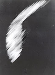 The first images from space were taken on sub-orbital flights
. The U.S-launched V-2 flight on October 24, 1946 took one image every 1.5 seconds. With an apogee of 65 miles (105 km), these photos were from five times higher than the previous record, the 13.7 miles (22 km) by the Explorer II balloon mission in 1935. The first satellite (orbital) photographs of Earth were made on August 14, 1959 by the U.S. Explorer 6
. The first satellite photographs of the Moon
might have been made on October 6, 1959 by the Soviet satellite Luna 3
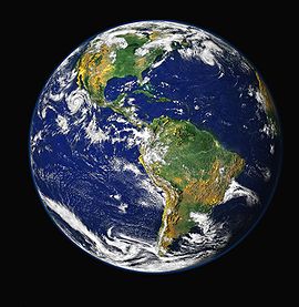
, on a mission to photograph the far side of the Moon. The Blue Marble photograph was taken from space in 1972, and has become very popular in the media and among the public. Also in 1972 the United States
started the Landsat program
, the largest program for acquisition of imagery of Earth from space. Landsat 7
, the most recent Landsat satellite, was launched in 1999. In 1977, the first real time satellite imagery was acquired by the USA's KH-11
satellite system.
 All satellite images produced by NASA
are published by Earth Observatory and are freely available to the public. Several other countries have satellite imaging programs, and a collaborative European effort launched the ERS
and Envisat
satellites carrying various sensors. There are also private companies that provide commercial satellite imagery. In the early 21st century satellite imagery became widely available when affordable, easy to use software with access to satellite imagery databases was offered by several companies and organizations.
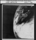
 Satellite images have many applications in meteorology
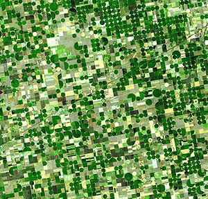
, agriculture
, geology
, forestry
, biodiversity conservation, regional planning
, education
, intelligence
and war
fare. Images can be in visible colours and in other spectra
. There are also elevation maps, usually made by radar imaging. Interpretation and analysis of satellite imagery is conducted using specialized remote sensing applications.
Some of the first image enhancement of satellite photos was conducted by the U.S. Government and its contractors. For example ESL Incorporated
developed some of the earliest two dimensional Fourier
transforms applied to digital image processing
to address NASA
photos as well as national security
applications. Satellite imagery is also used in seismology
and oceanography
in deducing changes to land formation, water depth and sea bed, by color caused by earthquake
s, volcano
es, and tsunami
s.
- spatial resolution is defined as the pixel size of an image representing the size of the surface area (i.e. m2) being measured on the ground, determined by the sensors' instantaneous field of view (IFOV);
- spectral resolution is defined by the wavelength interval size (discreet segment of the Electromagnetic Spectrum) and number intervals that the sensor is measuring; temporal resolution is defined by the amount of time (e.g. days) that passes between imagery collection periods for a given surface location; and radiometric resolution is defined as the ability of an imaging system to record many levels of brightness (contrast for example).
- Radiometric resolution refers to the effective bit-depth of the sensor (number of grayscale levels) and is typically expressed as 8-bit (0-255), 11-bit (0-2047), 12-bit (0-4095) or 16-bit (0-65,535).
- Geometric resolution refers to the satellite sensor's ability to effectively image a portion of the Earth's surface in a single pixel and is typically expressed in terms of Ground Sample Distance
, or GSD. GSD is a term containing the overall optical and systemic noise sources and is useful for comparing how well one sensor can "see" an object on the ground within a single pixel. For example, the GSD of Landsat is ~30m, which means the smallest unit that maps to a single pixel within an image is ~30m x 30m. The latest commercial satellite (GeoEye 1) has a GSD of 0.41 m (effectively 0.5 m due to US Govt restrictions on civilian imaging).
The resolution
of satellite images varies depending on the instrument used and the altitude of the satellite's orbit. For example, the Landsat archive offers repeated imagery at 30 meter resolution for the planet, but most of it has not been processed from the raw data. Landsat 7
has an average return period of 16 days. For many smaller areas, images with resolution as high as 41 cm can be available.
Satellite imagery is sometimes supplemented with aerial photography
, which has higher resolution, but is more expensive per square meter. Satellite imagery can be combined with vector or raster data in a GIS
provided that the imagery has been spatially rectified so that it will properly align with other data sets.
satellite was launched September 6, 2008. The GeoEye-1 satellite has the highest resolution of any commercial imaging system and is able to collect images with a ground resolution of 0.41 meters (16 inches) in the panchromatic or black and white mode. It collects multispectral or color imagery at 1.65-meter resolution or about 64 inches, a factor of two better than existing commercial satellites with four-band multistage imaging capabilities. While the satellite is able to collect imagery at 0.41 meters, GeoEye's operating license from the U.S. Government requires re-sampling the imagery to 0.5 meters for all customers not explicitly granted a waiver by the U.S. Government
satellite provided the world's highest resolution commercial satellite imagery (panchromatic only). The 0.5 meters resolution of WorldView-1's panchromatic
images allows the satellite to distinguish between objects on the ground that are at least 50 cm apart. Similarly DigitalGlobe's QuickBird
satellite provides 0.6 meter resolution (at NADIR) multispectral images.
in orbit (Spot 2, 4 and 5) provide images with a large choice of resolutions – from 2.5 m to 1 km. Spot Image also distributes multiresolution data from other optical satellites, in particular from Formosat-2 (Taiwan) and Kompsat-2 (South Korea) and from radar satellites (TerraSar-X, ERS, Envisat, Radarsat). Spot Image
will also be the exclusive distributor of data from the forthcoming very-high resolution Pleiades satellites
with a resolution of 0.50 meter or about 20 inches. The first launch is planned for the end of 2011. The company also offers infrastructures for receiving and processing, as well as added value options.
's constellation of five satellites, launched in August 2008, contain identical multispectral sensors which are equally calibrated. Therefore, an image from one satellite will be equivalent to an image from any of the other four, allowing for a large amount of imagery to be collected (4 million km² per day), and daily revisit to an area. Each travel on the same orbital plane at 630 km, and deliver images in 5 meter pixel size. RapidEye
satellite imagery is especially suited for agricultural, environmental, cartographic and disaster management applications. The company not only offers their imagery, but consults with their customers to create services and solutions based on analysis of this imagery .
, better known as “EROS” satellites, are lightweight, low earth orbiting, high-resolution satellites designed for fast maneuvering between imaging targets. In the commercial high-resolution satellite market, EROS is the smallest very high resolution satellite; it is very agile and thus enables very high performances. The satellites are deployed in a circular sun-synchronous near polar orbit at an altitude of 510 km (+/- 40 km).
EROS satellites imagery applications are primarily for intelligence, homeland security and national development purposes but also employed in a wide-range of civilian applications, including: mapping, border control, infrastructure planning, agricultural monitoring, environmental monitoring
, disaster response, training and simulations, etc.
EROS A – a high resolution satellite with 1.9-1.2M resolution panchromatic was launched on December 5, 2000.
EROS B - the second-generation of Very High Resolution satellites with 70 cm resolution panchromatic, was launched on April 25, 2006.
(creating useful images from the raw data) is time-consuming. Depending on the sensor
used, weather conditions can affect image quality: for example, it is difficult to obtain images for areas of frequent cloud cover such as mountain-tops.
Commercial satellite companies do not place their imagery into the public domain and do not sell their imagery; instead, one must be licensed to use their imagery. Thus, the ability to legally make derivative products from commercial satellite imagery is minimized.
Privacy
concerns have been brought up by some who wish not to have their property shown from above. Google Maps responds to such concerns in their FAQ
with the following statement: "We understand your privacy concerns... The images that Google Maps displays are no different from what can be seen by anyone who flies over or drives by a specific geographic location."
satellite in the Asia-Pacific. It is intended to provide true color, real-time live satellite feeds, with down to 250 metres resolution over the entire Asia-Pacific region, from India to Hawaii and Japan to Australia. They were going to provide this content to users of 3G mobile phones, over Pay TV as a weather channel, and to corporate and government users.
Unfortunately, the market response to the AstroVision concept fell into the classic chicken-egg problem: potential customers were excited by the possibilities offered, but they were unwilling (or, in government cases, generally unable) to sign contracts for a service that would not be delivered for 3–4 years (the length of time required to build and launch the satellite). AstroVision ran low on funds and was forced to shut down the program in 2006.
Earth
Earth is the third planet from the Sun, and the densest and fifth-largest of the eight planets in the Solar System. It is also the largest of the Solar System's four terrestrial planets...
or other planets made by means of artificial satellites.
History
Sub-orbital spaceflight
A sub-orbital space flight is a spaceflight in which the spacecraft reaches space, but its trajectory intersects the atmosphere or surface of the gravitating body from which it was launched, so that it does not complete one orbital revolution....
. The U.S-launched V-2 flight on October 24, 1946 took one image every 1.5 seconds. With an apogee of 65 miles (105 km), these photos were from five times higher than the previous record, the 13.7 miles (22 km) by the Explorer II balloon mission in 1935. The first satellite (orbital) photographs of Earth were made on August 14, 1959 by the U.S. Explorer 6
Explorer 6
Explorer 6 was a United States satellite launched on August 7, 1959. It was a small, spheroidal satellite designed to study trapped radiation of various energies, galactic cosmic rays, geomagnetism, radio propagation in the upper atmosphere, and the flux of micrometeorites...
. The first satellite photographs of the Moon
Moon
The Moon is Earth's only known natural satellite,There are a number of near-Earth asteroids including 3753 Cruithne that are co-orbital with Earth: their orbits bring them close to Earth for periods of time but then alter in the long term . These are quasi-satellites and not true moons. For more...
might have been made on October 6, 1959 by the Soviet satellite Luna 3
Luna 3
The Soviet space probe Luna 3 of 1959 was the third space probe to be sent to the neighborhood of the Moon, and this mission was an early feat in the spaceborne exploration of outer space...
, on a mission to photograph the far side of the Moon. The Blue Marble photograph was taken from space in 1972, and has become very popular in the media and among the public. Also in 1972 the United States
United States
The United States of America is a federal constitutional republic comprising fifty states and a federal district...
started the Landsat program
Landsat program
The Landsat program is the longest running enterprise for acquisition of satellite imagery of Earth. On July 26, 1972 the Earth Resources Technology Satellite was launched. This was eventually renamed to Landsat. The most recent, Landsat 7, was launched on April 15, 1999. The instruments on the...
, the largest program for acquisition of imagery of Earth from space. Landsat 7
Landsat 7
Landsat 7, launched on April 15, 1999, is the latest satellite of the Landsat program. Landsat 7's primary goal is to refresh the global archive of satellite photos, providing up-to-date and cloud-free images. The Landsat Program is managed and operated by the USGS, and data from Landsat 7 is...
, the most recent Landsat satellite, was launched in 1999. In 1977, the first real time satellite imagery was acquired by the USA's KH-11
KH-11
The KH-11 KENNAN, renamed CRYSTAL in 1982 and also referenced by the codenames 1010, and "Key Hole", is a type of reconnaissance satellite launched by the American National Reconnaissance Office since December 1976...
satellite system.
NASA
The National Aeronautics and Space Administration is the agency of the United States government that is responsible for the nation's civilian space program and for aeronautics and aerospace research...
are published by Earth Observatory and are freely available to the public. Several other countries have satellite imaging programs, and a collaborative European effort launched the ERS
European Remote-Sensing Satellite
European remote sensing satellite was the European Space Agency's first Earth-observing satellite. It was launched on July 17, 1991 into a Sun-synchronous polar orbit at a height of 782–785 km.-Instruments:...
and Envisat
Envisat
Envisat is an Earth-observing satellite. It was launched on 1 March 2002 aboard an Ariane 5 from the Guyana Space Centre in Kourou, French Guyana into a Sun synchronous polar orbit at an altitude of...
satellites carrying various sensors. There are also private companies that provide commercial satellite imagery. In the early 21st century satellite imagery became widely available when affordable, easy to use software with access to satellite imagery databases was offered by several companies and organizations.
Uses
Meteorology
Meteorology is the interdisciplinary scientific study of the atmosphere. Studies in the field stretch back millennia, though significant progress in meteorology did not occur until the 18th century. The 19th century saw breakthroughs occur after observing networks developed across several countries...
, agriculture
Agriculture
Agriculture is the cultivation of animals, plants, fungi and other life forms for food, fiber, and other products used to sustain life. Agriculture was the key implement in the rise of sedentary human civilization, whereby farming of domesticated species created food surpluses that nurtured the...
, geology
Geology
Geology is the science comprising the study of solid Earth, the rocks of which it is composed, and the processes by which it evolves. Geology gives insight into the history of the Earth, as it provides the primary evidence for plate tectonics, the evolutionary history of life, and past climates...
, forestry
Forestry
Forestry is the interdisciplinary profession embracing the science, art, and craft of creating, managing, using, and conserving forests and associated resources in a sustainable manner to meet desired goals, needs, and values for human benefit. Forestry is practiced in plantations and natural stands...
, biodiversity conservation, regional planning
Regional planning
Regional planning deals with the efficient placement of land use activities, infrastructure, and settlement growth across a larger area of land than an individual city or town. The related field of urban planning deals with the specific issues of city planning...
, education
Education
Education in its broadest, general sense is the means through which the aims and habits of a group of people lives on from one generation to the next. Generally, it occurs through any experience that has a formative effect on the way one thinks, feels, or acts...
, intelligence
Intelligence (information gathering)
Intelligence assessment is the development of forecasts of behaviour or recommended courses of action to the leadership of an organization, based on a wide range of available information sources both overt and covert. Assessments are developed in response to requirements declared by the leadership...
and war
War
War is a state of organized, armed, and often prolonged conflict carried on between states, nations, or other parties typified by extreme aggression, social disruption, and usually high mortality. War should be understood as an actual, intentional and widespread armed conflict between political...
fare. Images can be in visible colours and in other spectra
Electromagnetic spectrum
The electromagnetic spectrum is the range of all possible frequencies of electromagnetic radiation. The "electromagnetic spectrum" of an object is the characteristic distribution of electromagnetic radiation emitted or absorbed by that particular object....
. There are also elevation maps, usually made by radar imaging. Interpretation and analysis of satellite imagery is conducted using specialized remote sensing applications.
Some of the first image enhancement of satellite photos was conducted by the U.S. Government and its contractors. For example ESL Incorporated
ESL Incorporated
ESL Incorporated, or Electromagnetic Systems Laboratory, was a subsidiary of TRW, a high technology firm in the United States that was engaged in software design, systems analysis and hardware development for the strategic reconnaissance marketplace. Founded in January, 1964 in Palo Alto,...
developed some of the earliest two dimensional Fourier
Fourier
Fourier most commonly refers to Joseph Fourier , French mathematician and physicist, or the mathematics, physics, and engineering terms named in his honor for his work on the concepts underlying them:In mathematics:...
transforms applied to digital image processing
Digital image processing
Digital image processing is the use of computer algorithms to perform image processing on digital images. As a subcategory or field of digital signal processing, digital image processing has many advantages over analog image processing...
to address NASA
NASA
The National Aeronautics and Space Administration is the agency of the United States government that is responsible for the nation's civilian space program and for aeronautics and aerospace research...
photos as well as national security
National security
National security is the requirement to maintain the survival of the state through the use of economic, diplomacy, power projection and political power. The concept developed mostly in the United States of America after World War II...
applications. Satellite imagery is also used in seismology
Seismology
Seismology is the scientific study of earthquakes and the propagation of elastic waves through the Earth or through other planet-like bodies. The field also includes studies of earthquake effects, such as tsunamis as well as diverse seismic sources such as volcanic, tectonic, oceanic,...
and oceanography
Oceanography
Oceanography , also called oceanology or marine science, is the branch of Earth science that studies the ocean...
in deducing changes to land formation, water depth and sea bed, by color caused by earthquake
Earthquake
An earthquake is the result of a sudden release of energy in the Earth's crust that creates seismic waves. The seismicity, seismism or seismic activity of an area refers to the frequency, type and size of earthquakes experienced over a period of time...
s, volcano
Volcano
2. Bedrock3. Conduit 4. Base5. Sill6. Dike7. Layers of ash emitted by the volcano8. Flank| 9. Layers of lava emitted by the volcano10. Throat11. Parasitic cone12. Lava flow13. Vent14. Crater15...
es, and tsunami
Tsunami
A tsunami is a series of water waves caused by the displacement of a large volume of a body of water, typically an ocean or a large lake...
s.
Resolution and data
There are four types of resolution when discussing satellite imagery in remote sensing: spatial, spectral, temporal, and radiometric. Campbell (2002) defines these as follows:- spatial resolution is defined as the pixel size of an image representing the size of the surface area (i.e. m2) being measured on the ground, determined by the sensors' instantaneous field of view (IFOV);
- spectral resolution is defined by the wavelength interval size (discreet segment of the Electromagnetic Spectrum) and number intervals that the sensor is measuring; temporal resolution is defined by the amount of time (e.g. days) that passes between imagery collection periods for a given surface location; and radiometric resolution is defined as the ability of an imaging system to record many levels of brightness (contrast for example).
- Radiometric resolution refers to the effective bit-depth of the sensor (number of grayscale levels) and is typically expressed as 8-bit (0-255), 11-bit (0-2047), 12-bit (0-4095) or 16-bit (0-65,535).
- Geometric resolution refers to the satellite sensor's ability to effectively image a portion of the Earth's surface in a single pixel and is typically expressed in terms of Ground Sample Distance
Ground sample distance
In remote sensing, ground sample distance in a digital photo of the ground from air or space is the distance between pixel centers measured on the ground. For example, in an image with a one-meter GSD, adjacent pixels image locations that are 1 meter apart on the ground...
, or GSD. GSD is a term containing the overall optical and systemic noise sources and is useful for comparing how well one sensor can "see" an object on the ground within a single pixel. For example, the GSD of Landsat is ~30m, which means the smallest unit that maps to a single pixel within an image is ~30m x 30m. The latest commercial satellite (GeoEye 1) has a GSD of 0.41 m (effectively 0.5 m due to US Govt restrictions on civilian imaging).
The resolution
Image resolution
Image resolution is an umbrella term that describes the detail an image holds. The term applies to raster digital images, film images, and other types of images. Higher resolution means more image detail....
of satellite images varies depending on the instrument used and the altitude of the satellite's orbit. For example, the Landsat archive offers repeated imagery at 30 meter resolution for the planet, but most of it has not been processed from the raw data. Landsat 7
Landsat 7
Landsat 7, launched on April 15, 1999, is the latest satellite of the Landsat program. Landsat 7's primary goal is to refresh the global archive of satellite photos, providing up-to-date and cloud-free images. The Landsat Program is managed and operated by the USGS, and data from Landsat 7 is...
has an average return period of 16 days. For many smaller areas, images with resolution as high as 41 cm can be available.
Satellite imagery is sometimes supplemented with aerial photography
Aerial photography
Aerial photography is the taking of photographs of the ground from an elevated position. The term usually refers to images in which the camera is not supported by a ground-based structure. Cameras may be hand held or mounted, and photographs may be taken by a photographer, triggered remotely or...
, which has higher resolution, but is more expensive per square meter. Satellite imagery can be combined with vector or raster data in a GIS
Geographic Information System
A geographic information system, geographical information science, or geospatial information studies is a system designed to capture, store, manipulate, analyze, manage, and present all types of geographically referenced data...
provided that the imagery has been spatially rectified so that it will properly align with other data sets.
GeoEye
GeoEye's GeoEye-1GeoEye-1
GeoEye-1 is a high-resolution earth observation satellite owned by GeoEye, which was launched in September 2008.-History:On December 1, 2004, General Dynamics C4 Systems announced it had been awarded a contract worth approximately $209 million to build the OrbView-5 satellite...
satellite was launched September 6, 2008. The GeoEye-1 satellite has the highest resolution of any commercial imaging system and is able to collect images with a ground resolution of 0.41 meters (16 inches) in the panchromatic or black and white mode. It collects multispectral or color imagery at 1.65-meter resolution or about 64 inches, a factor of two better than existing commercial satellites with four-band multistage imaging capabilities. While the satellite is able to collect imagery at 0.41 meters, GeoEye's operating license from the U.S. Government requires re-sampling the imagery to 0.5 meters for all customers not explicitly granted a waiver by the U.S. Government
DigitalGlobe
Before the launch of GeoEye-1, DigitalGlobe's WorldView-1WorldView-1
WorldView-1 is a commercial earth observation satellite owned by DigitalGlobe. It was launched September 18, 2007, and DigitalGlobe plans to launch another, similar satellite after its construction is finished in late 2008...
satellite provided the world's highest resolution commercial satellite imagery (panchromatic only). The 0.5 meters resolution of WorldView-1's panchromatic
Panchromatic
Panchromatic film is a type of black-and-white photographic film that is sensitive to all wavelengths of visible light. A panchromatic film therefore produces a realistic reproduction of a scene as it appears to the human eye. Almost all modern photographic film is panchromatic, but some types are...
images allows the satellite to distinguish between objects on the ground that are at least 50 cm apart. Similarly DigitalGlobe's QuickBird
QuickBird
QuickBird is a high-resolution commercial earth observation satellite, owned by DigitalGlobe and launched in 2001 as the first satellite in a constellation of three scheduled to be in orbit by 2008...
satellite provides 0.6 meter resolution (at NADIR) multispectral images.
Spot Image
The 3 SPOT satellitesSPOT (satellites)
SPOT is a high-resolution, optical imaging Earth observation satellite system operating from space. It is run by Spot Image based in Toulouse, France...
in orbit (Spot 2, 4 and 5) provide images with a large choice of resolutions – from 2.5 m to 1 km. Spot Image also distributes multiresolution data from other optical satellites, in particular from Formosat-2 (Taiwan) and Kompsat-2 (South Korea) and from radar satellites (TerraSar-X, ERS, Envisat, Radarsat). Spot Image
Spot Image
Spot Image, a public limited company created in 1982 by the French Space Agency, Centre National d'Etudes Spatiales , the IGN, and Space Manufacturers is a subsidiary of EADS Astrium...
will also be the exclusive distributor of data from the forthcoming very-high resolution Pleiades satellites
Pleiades satellites
The Pléiades constellation is composed of two very-high-resolution optical Earth-imaging satellites. Pléiades 1 and Pléiades 2 will provide coverage of Earth’s surface with a repeat cycle of 26 days ....
with a resolution of 0.50 meter or about 20 inches. The first launch is planned for the end of 2011. The company also offers infrastructures for receiving and processing, as well as added value options.
RapidEye
RapidEyeRapidEye
RapidEye AG is a German geospatial information provider focused on assisting in management decision-making through services based on their own Earth observation imagery. The company owns a five satellite constellation producing 5 meter resolution imagery that was designed and implemented by ...
's constellation of five satellites, launched in August 2008, contain identical multispectral sensors which are equally calibrated. Therefore, an image from one satellite will be equivalent to an image from any of the other four, allowing for a large amount of imagery to be collected (4 million km² per day), and daily revisit to an area. Each travel on the same orbital plane at 630 km, and deliver images in 5 meter pixel size. RapidEye
RapidEye
RapidEye AG is a German geospatial information provider focused on assisting in management decision-making through services based on their own Earth observation imagery. The company owns a five satellite constellation producing 5 meter resolution imagery that was designed and implemented by ...
satellite imagery is especially suited for agricultural, environmental, cartographic and disaster management applications. The company not only offers their imagery, but consults with their customers to create services and solutions based on analysis of this imagery .
ImageSat International
Earth Resource Observation SatellitesEROS (satellite)
Earth Resources Observation Satellite is a series of Israeli commercial Earth observation satellites, designed and manufactured by Israel Aircraft Industries , with optical payload supplied by El-Op. The satellites are owned and operated by ImageSat International, another Israeli company, with...
, better known as “EROS” satellites, are lightweight, low earth orbiting, high-resolution satellites designed for fast maneuvering between imaging targets. In the commercial high-resolution satellite market, EROS is the smallest very high resolution satellite; it is very agile and thus enables very high performances. The satellites are deployed in a circular sun-synchronous near polar orbit at an altitude of 510 km (+/- 40 km).
EROS satellites imagery applications are primarily for intelligence, homeland security and national development purposes but also employed in a wide-range of civilian applications, including: mapping, border control, infrastructure planning, agricultural monitoring, environmental monitoring
Environmental monitoring
Environmental monitoring describes the processes and activities that need to take place to characterise and monitor the quality of the environment...
, disaster response, training and simulations, etc.
EROS A – a high resolution satellite with 1.9-1.2M resolution panchromatic was launched on December 5, 2000.
EROS B - the second-generation of Very High Resolution satellites with 70 cm resolution panchromatic, was launched on April 25, 2006.
Disadvantages
Because the total area of the land on Earth is so large and because resolution is relatively high, satellite databases are huge and image processingImage processing
In electrical engineering and computer science, image processing is any form of signal processing for which the input is an image, such as a photograph or video frame; the output of image processing may be either an image or, a set of characteristics or parameters related to the image...
(creating useful images from the raw data) is time-consuming. Depending on the sensor
Sensor
A sensor is a device that measures a physical quantity and converts it into a signal which can be read by an observer or by an instrument. For example, a mercury-in-glass thermometer converts the measured temperature into expansion and contraction of a liquid which can be read on a calibrated...
used, weather conditions can affect image quality: for example, it is difficult to obtain images for areas of frequent cloud cover such as mountain-tops.
Commercial satellite companies do not place their imagery into the public domain and do not sell their imagery; instead, one must be licensed to use their imagery. Thus, the ability to legally make derivative products from commercial satellite imagery is minimized.
Privacy
Privacy
Privacy is the ability of an individual or group to seclude themselves or information about themselves and thereby reveal themselves selectively...
concerns have been brought up by some who wish not to have their property shown from above. Google Maps responds to such concerns in their FAQ
FAQ
Frequently asked questions are listed questions and answers, all supposed to be commonly asked in some context, and pertaining to a particular topic. "FAQ" is usually pronounced as an initialism rather than an acronym, but an acronym form does exist. Since the acronym FAQ originated in textual...
with the following statement: "We understand your privacy concerns... The images that Google Maps displays are no different from what can be seen by anyone who flies over or drives by a specific geographic location."
Moving images
In 2005 the Australian company Astrovision (ASX: HZG) announced plans to launch the first commercial geostationaryGeostationary orbit
A geostationary orbit is a geosynchronous orbit directly above the Earth's equator , with a period equal to the Earth's rotational period and an orbital eccentricity of approximately zero. An object in a geostationary orbit appears motionless, at a fixed position in the sky, to ground observers...
satellite in the Asia-Pacific. It is intended to provide true color, real-time live satellite feeds, with down to 250 metres resolution over the entire Asia-Pacific region, from India to Hawaii and Japan to Australia. They were going to provide this content to users of 3G mobile phones, over Pay TV as a weather channel, and to corporate and government users.
Unfortunately, the market response to the AstroVision concept fell into the classic chicken-egg problem: potential customers were excited by the possibilities offered, but they were unwilling (or, in government cases, generally unable) to sign contracts for a service that would not be delivered for 3–4 years (the length of time required to build and launch the satellite). AstroVision ran low on funds and was forced to shut down the program in 2006.
See also
- Earth observation satelliteEarth observation satelliteEarth observation satellites are satellites specifically designed to observe Earth from orbit, similar to reconnaissance satellites but intended for non-military uses such as environmental monitoring, meteorology, map making etc....
- Google MapsGoogle MapsGoogle Maps is a web mapping service application and technology provided by Google, free , that powers many map-based services, including the Google Maps website, Google Ride Finder, Google Transit, and maps embedded on third-party websites via the Google Maps API...
- MODISMODISThe Moderate-resolution Imaging Spectroradiometer is a payload scientific instrument launched into Earth orbit by NASA in 1999 on board the Terra Satellite, and in 2002 on board the Aqua satellite...
- Remote sensingRemote sensingRemote sensing is the acquisition of information about an object or phenomenon, without making physical contact with the object. In modern usage, the term generally refers to the use of aerial sensor technologies to detect and classify objects on Earth by means of propagated signals Remote sensing...
- SRTM
- Virtual globeVirtual globeA virtual globe is a 3D software model or representation of the Earth or another world. A virtual globe provides the user with the ability to freely move around in the virtual environment by changing the viewing angle and position. Compared to a conventional globe, virtual globes have the...
- Google EarthGoogle EarthGoogle Earth is a virtual globe, map and geographical information program that was originally called EarthViewer 3D, and was created by Keyhole, Inc, a Central Intelligence Agency funded company acquired by Google in 2004 . It maps the Earth by the superimposition of images obtained from satellite...
- NASA World WindNASA World WindWorld Wind is an open-source virtual globe developed by NASA and the open source community for use on personal computers. Old versions need Microsoft Windows but the more recent Java version, , is cross platform and provides a suite of . The World Wind Java version was awarded in November 2009...
- Google Earth
- Spy satelliteSpy satelliteA spy satellite is an Earth observation satellite or communications satellite deployed for military or intelligence applications....
- StratelliteStratelliteStratellite is a brand name trademark of Sanswire for a future emissions-free, high-altitude stratospheric airship that provides a stationary communications platform for various types of wireless signals usually carried by communications towers or satellites...
- TerraServer-USATerraServer-USAMicrosoft Research Maps or MSR Maps is a free online repository of public domain aerial imagery and topographic maps provided by the U.S. Geological Survey . The site is a collaboration between Microsoft Research , Bing Maps, and the USGS. It has been under continuous operation since June 1998. It...
(now Microsoft Research Maps) - Terraserver.comTerraserver.comTerraServer is a commercial website specializing in aerial and satellite imagery which was originally launched in 1997. It is owned and operated by TerraServer.com, Inc. in Raleigh, North Carolina...
- Virtual EarthVirtual earthVirtual earth may refer to:* Virtual ground - the node of an electrical circuit that is maintained at a steady reference potential, without being connected directly to the reference potential....
External links
- Earth Snapshot - Web Portal dedicated to Earth Observation. Includes commented satellite images, information on storms, hurricanes, fires and meteorological phenomena.
- MODIS Image of the Day - Google Gadget referring to MODIS image of the day.
- Miravi - Meris Image Rapid Visualization. MIRAVI shows the gallery of images generated on the Level0 (raw data) Meris Full Resolution (300m) products, few seconds after their availability.
- Satellite Views - Free Satellite Views and Maps of over 5.9 Million Places.
- SRRS - Satellite Rapid Response System. Like MIRAVI but including also ASAR, MERIS Full and Reduced Resolution and ALOS AVNIR2 images.
- ESA Envisat Meris - 300m - the most detailed image of the entire Earth to date, made by the European Space Agency's Envisat Meris.
- Blue Marble: Next Generation - a detailed true-color image of the entire Earth.
- World Wind - an open sourceOpen sourceThe term open source describes practices in production and development that promote access to the end product's source materials. Some consider open source a philosophy, others consider it a pragmatic methodology...
3D Earth-viewing software developed by NASANASAThe National Aeronautics and Space Administration is the agency of the United States government that is responsible for the nation's civilian space program and for aeronautics and aerospace research...
that accesses NASA JPLJet Propulsion LaboratoryJet Propulsion Laboratory is a federally funded research and development center and NASA field center located in the San Gabriel Valley area of Los Angeles County, California, United States. The facility is headquartered in the city of Pasadena on the border of La Cañada Flintridge and Pasadena...
database - Google Earth - GoogleGoogleGoogle Inc. is an American multinational public corporation invested in Internet search, cloud computing, and advertising technologies. Google hosts and develops a number of Internet-based services and products, and generates profit primarily from advertising through its AdWords program...
's commercial 3D Earth-viewing software- Free. - Google Maps satellite imagery
- Microsoft Research Maps - formerly TerraServer-USA and Microsoft TerraServer, a repository of free USGS images of the United States
- Satellite Images of China - Images of Taklamakan desert, salt lakes, wind parks, infrastructure, cities.
- Google Earth Anomalies- Satellite imagery of documented, scientific anomaly sites including mound sites and unexplained circular features via Google Earth.