
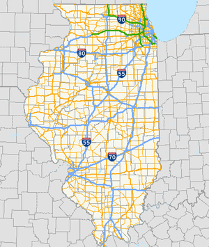
List of Illinois Routes
Encyclopedia
State highway
State highway, state road or state route can refer to one of three related concepts, two of them related to a state or provincial government in a country that is divided into states or provinces :#A...
system for the U.S. state
U.S. state
A U.S. state is any one of the 50 federated states of the United States of America that share sovereignty with the federal government. Because of this shared sovereignty, an American is a citizen both of the federal entity and of his or her state of domicile. Four states use the official title of...
of Illinois
Illinois
Illinois is the fifth-most populous state of the United States of America, and is often noted for being a microcosm of the entire country. With Chicago in the northeast, small industrial cities and great agricultural productivity in central and northern Illinois, and natural resources like coal,...
, was created in 1918 with the first State Bond Issue (SBI) Routes, 1 through 46. Bonds were floated to pay for specific routes. SBI # 1 paid for Route 1, and so on. These initial 46 route numbers marked the major infrastructure roads desired by the state legislature in 1918.
Remarkably, many of these numbers still exist on the original or nearby alignment. As the highway system grew these numbers were altered to accommodate new roads or extensions of older roads.
In 1924, additional State Bond Issues were authorized for SBI Routes 47 through 185. These route numbers were originally assigned and grouped to specific regions of the state. Thus, it is not uncommon to find groups of routes with similar numbers around each other (routes 23, 26, and 29 are found in north-central Illinois, while routes 56, 58, 59, 60, 62, 64, 68 and 72 are all be found in northeastern Illinois and routes 100, 101, 103, 104, 105, 107 are found in western Illinois west of the Illinois River and largely south of McDonough County line.
SBI Route numbers that were superseded by other routes, US or state routes were often reused. For example, SBI Route 61 was originally assigned to a road segment in northeastern Illinois, but was reassigned to a route in western Illinois, sometime after 1937.
SBI Numbers are still used for several purposes, even when they do not match the posted number. IDOT District maps still refer to SBI numbers on the various roads it maintains, along with other non-posted designations that refer to how the route was authorized. Bridge weight plates refer to SBI numbers instead of posted route numbers as well. For example, bridge plates along old US-66 refer to the route as "SBI-4"
When the US Highway System of Interstate Roads started to be posted in 1926, the US numbers were just tacked onto the existing IL/SBI number unless the US route was routed along a new route.
Illinois Highway Code
The Illinois Highway Code in the Illinois Compiled Statutes states that all state highways are to be numbered, and that no state highway shall go unnumbered. In addition, roads in the system include state highways that connectDescriptions of each individual state highway are filed with the county clerk of the county in which the state highway resides. State highways may be maintained by either the municipalities
Municipality
A municipality is essentially an urban administrative division having corporate status and usually powers of self-government. It can also be used to mean the governing body of a municipality. A municipality is a general-purpose administrative subdivision, as opposed to a special-purpose district...
if within a municipality, or the Illinois Department of Transportation. Should a highway run through a municipality, IDOT is authorized to choose a route through the municipality in order to make a route contiguous for through traffic.
1-10
| Route name | Region | Orientation | Length | |
|---|---|---|---|---|
| Miles | Kilometers | |||
 Illinois Route 1 Illinois Route 1Illinois Route 1 Illinois Route 1 is a state highway in the U.S. state of Illinois. Running parallel to the Indiana border, it is also the longest state road, starting on the south side of Chicago as Halsted Street at the intersection with 95th Street, south to a free ferry crossing to Kentucky at Cave-In-Rock on... |
Eastern | North-south | 336 | 541 |
 Illinois Route 2 Illinois Route 2Illinois Route 2 Illinois Route 2 is a north–south state road in northern Illinois. It currently starts at Illinois Route 40 in Sterling and ends at the Wisconsin state line north of South Beloit, very near the intersection with U.S. Route 51, Illinois Route 75 and Illinois Route 251. Illinois 2 is long.-... |
Northwestern | East-west | 120 | 194 |
 Illinois Route 3 Illinois Route 3Illinois Route 3 Illinois Route 3 is a major north–south arterial state highway in southwestern Illinois. It has its southern terminus at Cairo Junction at the intersection of Interstate 57 and U.S. Route 51, and its northern terminus in Grafton at Illinois Route 100... |
Southwestern | North-south | 190 | 306 |
 Illinois Route 4 Illinois Route 4Illinois Route 4 Illinois Route 4 is a long state road that runs south from the Interstate 55 business loop around Springfield south to Illinois Route 13 just north of Murphysboro. This is a distance of .-Route description:... |
Central | North-south | 160 | 257 |
 Illinois Route 4A Illinois Route 4A |
||||
 Illinois Route 5 Illinois Route 5Illinois Route 5 Illinois Route 5 is a four-lane road that runs from U.S. Route 67 in Rock Island to the interchange of Interstate 80 and the toll-free portion of Interstate 88, a distance of... |
Northwestern | East-west | 20 | 32 |
 Illinois Route 6 Illinois Route 6Illinois Route 6 Illinois Route 6 is a 4-lane freeway in central Illinois. It begins as a northern extension of Interstate 474 at Interstate 74 west of Peoria, and ends at Illinois Route 29 in Mossville, south of Chillicothe... |
Central | North-south | 10.06 | 16.19 |
 Illinois Route 7 Illinois Route 7Illinois Route 7 Illinois Route 7 is a north–south state road in northeastern Illinois. Currently, Illinois 7 runs from U.S. Route 6 at Rockdale north through Joliet, into Lockport, and then east to Orland Park before terminating at Illinois Route 43 in Worth... |
Northeastern | Southwest-northeast (marked north-south) | 25 | 40 |
 Illinois Route 8 Illinois Route 8Illinois Route 8 Illinois Route 8 is an east–west state road in central Illinois. It runs east from Illinois Route 97 south of Maquon to the intersection of U.S. Route 24 and Business U.S. 24 near Washington. Illinois 8 is long.- Route description :... |
Central | East-west | 60 | 97 |
 Illinois Route 9 Illinois Route 9Illinois Route 9 Illinois Route 9 is a cross-state, east–west rural state highway in central Illinois. It runs from the Fort Madison Toll Bridge over the Mississippi River to Iowa in Niota east to State Road 26 at the Indiana border. This is a distance of .... |
Central | East-west | 190 | 306 |
 Illinois Route 10 Illinois Route 10Illinois Route 10 Illinois Route 10 is an arterial east–west state road that runs from rural Mason County east to Champaign, a distance of .-Route description:... |
Central | East-west | 91 | 146 |
11-20
| Route name | Region | Orientation | Length | |
|---|---|---|---|---|
| Miles | Kilometers | |||
 Illinois Route 11 Illinois Route 11 |
||||
 Illinois Route 12 Illinois Route 12 |
||||
 Illinois Route 13 Illinois Route 13Illinois Route 13 Illinois Route 13 is a major east–west state route in southern Illinois. Illinois 13 has its western terminus at Centreville at Illinois Route 157 and its eastern terminus at the Kentucky state line and the Ohio River, at Kentucky Route 56. This is a distance of .- Route description :Illinois... |
South central | East-west | 152 | 244 |
 Illinois Route 14 Illinois Route 14Illinois Route 14 Illinois Route 14 is a major east–west highway in southern Illinois. It runs from U.S. Route 51 south of Du Quoin to the New Harmony Toll Bridge over the Wabash River to State Road 66 at the Indiana state line... |
South central | East-west | 81 | 130 |
 Illinois Route 15 Illinois Route 15Illinois Route 15 Illinois Route 15 is an east–west highway with its western terminus at Illinois Route 3, U.S. Route 40, I-55, I-64, and I-70 and its eastern terminus at Wabash River at the Illinois/Indiana Border where it meets Indiana 64. This is a distance of .... |
Southern | East-west | 144 | 232 |
 Illinois Route 16 Illinois Route 16Illinois Route 16 Illinois Route 16 is an arterial east–west highway in central Illinois. Its western terminus is at the Joe Page Bridge over the Illinois River in Hardin, while its eastern terminus is at Paris at Illinois Route 1 and U.S. Route 150, with Illinois Route 133. This is a distance of .- Route... |
Central | East-west | 172 | 277 |
 Illinois Route 17 Illinois Route 17Illinois Route 17 Illinois Route 17 is a rural, arterial east–west state road that runs east from a former ferry crossing in New Boston along the banks of the Mississippi River to State Road 2 west of Lowell, Indiana. It is long.- Route description :... |
North central | East-west | 203 | 327 |
 Illinois Route 18 Illinois Route 18Illinois Route 18 Illinois Route 18 is a rural east–west state road in central Illinois. It runs east from the town of Henry at Illinois Route 29 to the town of Blackstone at Illinois Route 17. This is a distance of .- Route description :... |
Central | East-west | 37 | 60 |
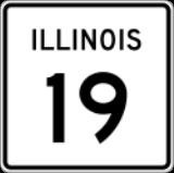
 Illinois Route 19 Illinois Route 19Illinois Route 19 Illinois Route 19 is a major east–west arterial road in northeastern Illinois, United States. It runs from Illinois Route 25 in Elgin, to Lake Shore Drive on the north side of Chicago. Illinois 19 is long... |
Northeastern | East-west | 33.22 | 53.46 |
 Illinois Route 20 Illinois Route 20 |
||||
21-30
| Route name | Region | Orientation | Length | |
|---|---|---|---|---|
| mi | km | |||
 Illinois Route 21 Illinois Route 21Illinois Route 21 Illinois Route 21 is an arterial north–south state highway in northeastern Illinois. It runs from Illinois Route 43 in Niles to U.S. Route 41 north of Gurnee. Illinois 21 is 28.13 miles long.... |
Northern | East-west | 28.13 | 45.27 |
 Illinois Route 22 Illinois Route 22Illinois Route 22 Illinois Route 22, also known as Half Day Road for part of its length, is an east–west state highway in northeastern Illinois. It runs from U.S. Route 14 in Fox River Grove to U.S. Route 41 in Highland Park... |
Northeastern | East-west | 19.70 | 31.70 |
 Illinois Route 23 Illinois Route 23Illinois Route 23 Illinois Route 23 is a north–south state highway in northern Illinois. It runs from Illinois Route 116 in Pontiac north to U.S. Route 14 south of Harvard. This is a distance of .-Route description:... |
Central | North-south | 126.17 | 203.05 |
 Illinois Route 24 Illinois Route 24 |
||||
 Illinois Route 25 Illinois Route 25Illinois Route 25 Illinois Route 25 is a state road in northeast Illinois. It runs north from U.S. Highway 34 in Oswego to Illinois Route 62 in Algonquin. Illinois 25 is in length.- Route description :... |
Northeastern | North-south | 35.04 | 56.39 |
 Illinois Route 26 Illinois Route 26Illinois Route 26 Illinois Route 26 is a north–south state road in central and north-central Illinois. It runs from Illinois Route 116 just north of East Peoria to Highway 69 at the Wisconsin border near Orangeville. This is a distance of .- Route description :... |
Central | North-south | 139.35 | 224.26 |
 Illinois Route 27 Illinois Route 27 |
||||
 Illinois Route 28 Illinois Route 28U.S. Route 34 in Illinois In the U.S. state of Illinois, U.S. Route 34 is an east–west highway that runs from the Iowa state line at Gulport west of Galesburg to Illinois Route 43 and Historic US 66 at Harlem Avenue in Berwyn. The entire highway in Illinois is named the "Walter Payton Memorial Highway"... |
||||
 Illinois Route 29 Illinois Route 29Illinois Route 29 Illinois Route 29 is a two to four lane state road that runs south from U.S. Route 6/Illinois Route 89 at Spring Valley to U.S. Route 51/Illinois Route 16 at Pana, running through Pekin, Peoria and Springfield. The nearest major north–south highway, Interstate 39, runs parallel to Illinois... |
North-central | North-south | 175.36 | 282.21 |
 Illinois Route 30 Illinois Route 30 |
||||
31-40
| Route name | Region | Orientation | Length | |
|---|---|---|---|---|
| mi | km | |||
 Illinois Route 31 Illinois Route 31Illinois Route 31 Illinois Route 31 is a north–south state road in northeastern Illinois, United States. It runs from U.S. Highway 34 in Oswego north to U.S. Highway 12, near the Wisconsin border, just south of Richmond. Illinois 31 is long.- Route description :... |
Northeastern | North-south | 58.41 | 94.00 |
 Illinois Route 32 Illinois Route 32Illinois Route 32 Illinois Route 32 is a north–south highway with its southern terminus at U.S. Route 40 and Illinois Route 33 in Effingham and its northern terminus at Illinois Route 48 at Cisco, a few hundred feet south of Interstate 72... |
Central | North-south | 69.32 | 111.56 |
 Illinois Route 33 Illinois Route 33Illinois Route 33 Illinois Route 33 is a multidirectional highway in southeastern Illinois, with its western terminus at Illinois Route 128 on the Fayette–Effingham county line near Beecher City and its southern terminus at U.S. Highway 50 east of Lawrenceville. It also overlaps Illinois Route 32 from Shumway to... |
Eastern | Multidirectional | 97.17 | 156.38 |
 Illinois Route 34 Illinois Route 34Illinois Route 34 Illinois Route 34 is a north–south state road in southern Illinois. It runs from a former ferry crossing to Kentucky Route 297 across the Ohio River in Rosiclare to Illinois Routes 14/37 in Benton. This is a distance of .- Route description :... |
Southern | North-south | 61.74 | 99.36 |
 Illinois Route 35 Illinois Route 35Illinois Route 35 Illinois Route 35 is a connector road between U.S. Route 20 in East Dubuque and Highway 35 at the Wisconsin state line. It is currently the shortest state highway in Illinois, a stark contrast to the highway north of the state line, which is Wisconsin's longest highway.- Route description :ILL 35... |
Northwestern | East-west | 2.42 | 3.89 |
 Illinois Route 36 Illinois Route 36 |
||||
 Illinois Route 37 Illinois Route 37Illinois Route 37 Illinois Route 37, or Illinois 37, is a north–south route in southern Illinois. It is in length. Originally connecting Effingham to Cairo, it was a heavily-traveled highway before Interstate 57 was opened. That Interstate, which lies very close to most of Illinois 37 , supplanted it as a... |
Southern | North-south | 155.07 | 249.56 |
 Illinois Route 38 Illinois Route 38Illinois Route 38 Illinois Route 38 is an east–west state road that runs across northern Illinois. It runs from U.S. Route 52 in downtown Dixon to U.S. Highways 12, 20, and 45 in Westchester. This is a distance of . As Roosevelt Road it continues through Forest Park and into Cicero and Chicago before... |
Northern | East-west | 89.28 | 143.68 |
 Illinois Route 39 Illinois Route 39 |
||||
 Illinois Route 40 Illinois Route 40Illinois Route 40 Illinois Route 40 is a north–south route in central portion of the U.S. state of Illinois. It runs from Interstate 74 in East Peoria north to Illinois Route 78 at Mt. Carroll, just south of U.S. Route 52 and Illinois Route 64. This is a distance of .... |
Central | North-south | 112.05 | 180.33 |
41-50
 Illinois Route 41Illinois Route 41Illinois Route 41 is a north–south highway in rural west-central Illinois. It runs from U.S. Route 136 near Macomb north to U.S. Route 34 and Illinois Route 164 in Galesburg, a distance of . Illinois 41 is maintained by the Illinois Department of Transportation.-Route description:Illinois 41...
 Illinois Route 42
 Illinois Route 42A
 Illinois Route 43Illinois Route 43Illinois Route 43 is a major north–south state road in the U.S. state of Illinois. It runs from U.S. Route 30 in Frankfort north to the large intersection of Illinois Route 120 and U.S...
 Illinois Route 44
 Illinois Route 45
 Illinois Route 46
 Illinois Route 47Illinois Route 47Illinois Route 47 is a largely rural north–south state highway that runs from the Wisconsin state border at Highway 120 near Hebron, to Illinois Route 10, just south of Interstate 72 near Seymour. This is a distance of . Even though Route 47 is primarily rural, in several suburbs of Chicago,...
 Illinois Route 48Illinois Route 48Illinois Route 48 is a north–south highway with its southern terminus at I-55 and Illinois Route 127 in Raymond and its northern terminus at Illinois Route 54 east of Clinton. This is a distance of .- Route description :...
 Illinois Route 49Illinois Route 49Illinois Route 49 is a north–south state highway in east-central Illinois. It runs from Willow Hill at Illinois Route 33 north to the beginning of the U.S. Route 45/52 concurrency near Ashkum. This is a distance of .- Route description :...
 Illinois Route 50Illinois Route 50Illinois Route 50 is a north–south state road in northeastern Illinois. It runs from the junction with U.S. Route 45 in West Kankakee north to U.S. Route 41 in Skokie. This is a distance of . In Chicago and the suburbs it's known as Cicero Avenue...
51-60
 Illinois Route 51
 Illinois Route 52
 Illinois Route 53Illinois Route 53Illinois Route 53 is an arterial north–south state highway in northeast Illinois. Route 53 runs south from Long Grove at Illinois Route 83 to Gardner at Interstate 55 west of old U.S. Highway 66, a distance of...
 Illinois Route 54Illinois Route 54Illinois Route 54 is an east–west highway in east-central Illinois. It passes through the cities of Clinton , Gibson City, and Onarga. Its western terminus is at Interstate 55 in Springfield. Its eastern terminus is at U.S. Route 45 at Onarga, one mile east of Interstate 57...
 Illinois Route 55
 Illinois Route 56Illinois Route 56Illinois Route 56 is an east–west state road in northern and northeastern Illinois. It runs from the interchange of Illinois Route 47 at U.S. Route 30 in Sugar Grove east to US 12/US 20/US 45 by Bellwood...
 Illinois Route 57Illinois Route 57Illinois Route 57 is a north–south state highway in western Illinois. It runs from Interstate 172 in Fall Creek to U.S. Route 24 and Illinois Route 104 in Quincy, a distance of .- Route description :...
 Illinois Route 58Illinois Route 58Illinois Route 58 is a state highway in northeast Illinois. It runs from Illinois Route 25 in Elgin east to U.S. Route 41 in Skokie...
 Illinois Route 59Illinois Route 59Illinois Route 59 is a north–south state highway in northeastern Illinois. It runs south from Illinois Route 83 in Antioch to Interstate Highway 55 in Shorewood, spanning the north–south width of Chicago's western suburbs...
 Illinois Route 59A
 Illinois Route 60Illinois Route 60Illinois Route 60 is an east–west state highway in Lake County, in northeastern Illinois. It connects the village of Volo at Illinois Route 120 just east of Illinois Route 59 with the village of Lake Forest at U.S. Highway 41...
61-70A
 Illinois Route 61Illinois Route 61Illinois Route 61 is a rural state road in western Illinois that runs north and east from Illinois Route 96 in Ursa to the intersection of U.S. Route 136 west of Tennessee. Illinois route 61 is long.-Route description:...
 Illinois Route 62Illinois Route 62Illinois Route 62 is an east–west state road in northeast Illinois. It runs from downtown Algonquin at Illinois Route 31 to the intersection with Illinois Route 83 by industrial Mount Prospect. This is a distance of ....
 Illinois Route 63
 Illinois Route 64Illinois Route 64Illinois Route 64 is an east–west road in north-central Illinois. Its western terminus is at the Iowa state line, connecting with U.S. Route 52 and Iowa Highway 64 via the Savanna-Sabula Bridge at the Mississippi River west of Savanna...
 Illinois Route 65
 Illinois Route 66
 Illinois Route 67
 Illinois Route 68Illinois Route 68Illinois Route 68 is an east–west state highway in northeast Illinois. It runs east from Illinois Route 72 in the Dundee area to the Interstate 94/U.S. Route 41 concurrency in Glencoe. This is a distance of ....
 Illinois Route 69
 Illinois Route 70Illinois Route 70Illinois Route 70 is a state road in far north-central Illinois. It runs from Illinois Route 75 in Durand to Business U.S. Route 20 in Rockford. This is a distance of .- Route description :...
 Illinois Route 70A
71-80
 Illinois Route 71Illinois Route 71Illinois Route 71 is a long southwest-to-northeast state highway in north central Illinois. It runs from the end of Interstate 180 in Hennepin to U.S. Route 34 in Oswego...
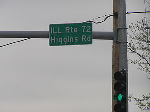
 Illinois Route 72Illinois Route 72Illinois Route 72 is an east–west state road in northeastern Illinois. It runs from the intersection with Illinois Route 73 north of Lanark east to Illinois Route 43 in Chicago...
 Illinois Route 73Illinois Route 73Illinois Route 73 is a north–south state highway in northwest Illinois. It runs from the U.S. Route 52/Illinois Route 64 concurrency south of Lanark north to the Wisconsin border north of Winslow. This is a distance of .- Route description :...
 Illinois Route 74
 Illinois Route 75Illinois Route 75Illinois Route 75 is an east–west state road in north-central Illinois. It runs from downtown Freeport at Illinois Route 26 to WIS 67 at the Wisconsin state line southeast of Beloit, Wisconsin. This is a distance of .- Route description :...
 Illinois Route 76Illinois Route 76Illinois Route 76 is a north–south state road in far north-central Illinois. It runs from the U.S. Highway 20 bypass around Belvidere north to the Wisconsin State Line at Highway 140. This is a distance of ....
 Illinois Route 77
 Illinois Route 78Illinois Route 78Illinois Route 78 is a major north–south highway in western Illinois. It runs from Illinois Route 104 northwest of Jacksonville north to Highway 78 at the Wisconsin state line north of Warren...
 Illinois Route 79
 Illinois Route 80
81-90
 Illinois Route 81Illinois Route 81Illinois Route 81 is an east–west state road in northwest Illinois. It runs from U.S. Route 150 by unincorporated Lynn Center to Illinois Route 78 in Kewanee. This is a distance of .- Route description :...
 Illinois Route 82Illinois Route 82Illinois Route 82 is a rural north–south state highway in west central Illinois. It currently runs from Illinois Route 17 in Nekoma north to Illinois Route 92 near Joslin. This is a distance of .- Route description :...
 Illinois Route 83Illinois Route 83Illinois Route 83 is a major north–south state road in northeast Illinois. It stretches from U.S. Highway 30 by Lynwood and Dyer, Indiana north to the Wisconsin border by Antioch at Highway 83. Incidentally, this alignment is concentric with Interstate 294...
- Illinois Route 83A
 Illinois Route 84Illinois Route 84Illinois Route 84 is a long state highway that runs along the Mississippi River in northwestern Illinois. Illinois 84 runs from south of Green Rock at U.S. Route 6 to the Wisconsin state line at Highway 80 by Hazel Green, Wisconsin. Illinois 84 is long.- Route description :Illinois Route 84...
 Illinois Route 85
 Illinois Route 86
 Illinois Route 87
 Illinois Route 88
- Illinois Route 88A
 Illinois Route 89Illinois Route 89Illinois Route 89 is a rural, north–south state highway in central Illinois. It runs from U.S. Route 34 in La Moille to Illinois Route 116 in Metamora. Routes 26 and 89 are the main north–south roads between Interstate 39/U.S. Route 51 and Illinois Route 29...
 Illinois Route 89A
 Illinois Route 89B
 Illinois Route 89C
 Illinois Route 90Illinois Route 90Illinois Route 90 is an east–west state highway in northern Peoria County in central Illinois. It runs from Illinois Route 78 in Laura to Illinois Route 40 in Edelstein. This is a distance of .- Route description :...
91-100
 Illinois Route 91Illinois Route 91Illinois Route 91 is a rural state road in central Illinois. It runs from the northwest edge of Peoria at U.S. Highway 150 to U.S. Highway 34 south of Kewanee. Illinois 91 is long.- Route description :...
 Illinois Route 92Illinois Route 92Illinois Route 92 is an east–west state highway in northwest Illinois. It runs from Iowa Highway 92 at the Norbert F. Beckey Bridge across the Mississippi River to Muscatine, Iowa east to U.S. Route 34 in La Moille. This is a distance of ....
 Illinois Route 93Illinois Route 93Illinois Route 93 is an east–west state road in central Illinois. It runs from Illinois Route 91, one mile west of Elmira to Illinois Route 40, one mile west of Bradford. This is a distance of .- Route description :...
 Illinois Route 94Illinois Route 94Illinois Route 94 is a north–south state highway in western Illinois. It runs from U.S. Route 24 just east of Camp Point to U.S. Route 67 just south of Oak Grove, just south of the Quad Cities area...
 Illinois Route 94A
 Illinois Route 94B
 Illinois Route 95Illinois Route 95Illinois Route 95 is a minor east–west state road in west central Illinois. It runs from Illinois Route 41 just west of New Philadelphia east to Illinois Route 97 just south of Cuba. This is a distance of .- Route description :...
- Illinois Route 95A
 Illinois Route 96Illinois Route 96Illinois Route 96 is a north–south state road in far western Illinois. It runs from Illinois Route 100 in Kampsville, not far from a ferry crossing across the Illinois River, to Illinois Route 94 north of Terre Haute. This is a distance of ....
 Illinois Route 97Illinois Route 97Illinois Route 97 is a north–south state highway in the central and western portions of the U.S. state of Illinois. It extends from exit 98 on Interstate 55 in Springfield northwest to U.S. Highway 150 near Galesburg. It crosses over the Illinois River on a bridge west of...
 Illinois Route 97A
 Illinois Route 98Illinois Route 98Illinois Route 98 is a east–west state highway located entirely within Tazewell County in central Illinois. The route runs from Routhe 29 on the border of Pekin and North Pekin east to Interstate 155 in Morton...
 Illinois Route 99Illinois Route 99Illinois Route 99 is a north–south state road in western Illinois. It runs from Illinois Route 104 across the Illinois River and Meredosia, north to Illinois Route 101 in Brooklyn . This is a distance of .- Route description :...
 Illinois Route 100Illinois Route 100Illinois Route 100 is a 157 mile highway in the southwest Illinois. It generally parallels the Illinois River. Starting in downtown Alton, it trends northward to Buckheart Township near Canton. It makes up much of the Illinois River Road, a U.S. National Scenic Byway...
101-110
 Illinois Route 101Illinois Route 101Illinois Route 101 is a east–west state road that runs from to the intersection of Illinois Route 61 in Augusta east to U.S. Highway 67 one mile east of Littleton. The highway was officially established in 1924 along its current alignment...
 Illinois Route 102Illinois Route 102Illinois Route 102 is a state route in northeast Illinois. It runs from Illinois Route 53 in Wilmington to the concurrency of U.S. Route 45 and U.S. Route 52 in Bradley, just north of Kankakee. This is a distance of .- Route description :...
 Illinois Route 103Illinois Route 103Illinois Route 103 is a state route in west-central Illinois, United States. The route, entirely in Schuyler County, runs from U.S. Route 24 near Ripley east to the intersection of U.S. Route 67 and Illinois Route 100 across the Illinois River from Beardstown. In addition to connecting Ripley and...
 Illinois Route 104Illinois Route 104Illinois Route 104 is a state highway in central and western Illinois. It extends from Illinois Route 29 near Taylorville, west over the Illinois River at Meredosia to its western terminus in downtown Quincy. This is a distance of .- Route description :...
 Illinois Route 105Illinois Route 105Illinois Route 105 is a highway in the U.S. state of Illinois. It is an east–west highway that runs from Illinois Route 48 in Decatur to Interstate 72 near Monticello. Illinois 105 is long.- Route description :...
 Illinois Route 106Illinois Route 106Illinois Route 106 is an east–west state highway in western Illinois. It runs from a new interchange with Interstate 72 near East Hannibal to U.S. Route 67 in White Hall. This is a distance of .- Route description :...
 Illinois Route 107Illinois Route 107Illinois Route 107 is a north–south state highway in western Illinois. It runs from the northern terminus of U.S. Route 54 between Pittsfield and Griggsville north to Illinois Route 99 in Mt. Sterling. This is a distance of .- Route description :...
 Illinois Route 108Illinois Route 108Illinois Route 108 is an east–west highway in western Illinois. Its western terminus is at Illinois Route 100 in Kampsville, and its eastern terminus is at Interstate 55 in Zanesville Township near Raymond. This is a distance of .- Route description :...
 Illinois Route 109Illinois Route 109Illinois Route 109 is a minor north–south state road in southwest Illinois. It runs from Illinois Route 3 east of Newbern north to U.S. Route 67 in Jerseyville. This is a distance of .- Route description :...
 Illinois Route 110
111-120
 Illinois Route 111Illinois Route 111Illinois Route 111 is a north–south state road in southwestern Illinois. It runs from Short Street in Centreville to Illinois Route 104 in Waverly. This is a distance of .- Route description :...
- Illinois Route 112
 Illinois Route 113Illinois Route 113Illinois Route 113 is a two-lane state road that runs east from Illinois Route 47 north of Mazon and east of Seneca to Illinois Route 17 in western Kankakee, just across the Kankakee River from U.S. Route 45 and U.S. Route 52...
- Illinois Route 113N
- Illinois Route 113S
 Illinois Route 114Illinois Route 114Illinois Route 114 is a rural east–west road that connects State Road 10 in Indiana, USA, with Illinois Route 1 and Illinois Route 17 , which overlap in Momence...
 Illinois Route 115Illinois Route 115Illinois Route 115 is a minor north–south road in northeastern Illinois. It runs from Illinois Route 9 near Perdueville to the concurrent U.S. Routes 45/52 in Kankakee. This is a distance of .- Route description :...
 Illinois Route 116Illinois Route 116Illinois Route 116 is a cross-state rural state highway that runs from U.S. Route 34 by Gladstone east to the intersection of U.S. Route 45 and Old U.S. Route 45, on the north side of Ashkum...
- Illinois Route 116A
 Illinois Route 117Illinois Route 117Illinois Route 117 is a rural north–south state road in north central Illinois. It travels from Interstate 74 in the small community of Goodfield to Illinois Route 17 in Toluca. Illinois 117 covers a distance of about .- Route description :...
 Illinois Route 118
 Illinois Route 119Illinois Route 119Illinois Route 119 is an east–west state road in east-central Illinois. It runs from the intersection of U.S. Route 136 and Illinois Route 1 east of Henning to State Road 28 at the Indiana state line, well west of Williamsport, Indiana. This is a distance of .- Route description :Illinois 119...
 Illinois Route 120Illinois Route 120Illinois Route 120 is a major east–west state highway in northeastern Illinois. It runs from U.S. Route 14 near Woodstock to Illinois Route 131 in Waukegan. It travels a distance of and is one of the few roads that provides direct access from McHenry County to Interstate 94 in Lake County...
121-130A
 Illinois Route 121Illinois Route 121Illinois Route 121 is a major state road in central Illinois. Although it runs from northwest to southeast, it is marked as a north–south road. It runs from Illinois Route 130 in Greenup to Interstate 55 in Lincoln at the intersection of I-55 and Illinois Route 10...
 Illinois Route 122Illinois Route 122Illinois Route 122 is an east–west highway in the U.S. state of Illinois. Its western terminus is at a junction with Illinois Route 29 west of Delavan. It runs east to a junction with Illinois Route 9 in McLean County west of Bloomington. Illinois 122 is long.-Route Description:Illinois...
 Illinois Route 123Illinois Route 123Illinois Route 123 is an east–west state highway in central Illinois, USA. long, it stretches from Interstate 55 exit #109 at Williamsville to Illinois Route 125 near Pleasant Plains.- Route description :...
 Illinois Route 124Illinois Route 124Illinois Route 124 is a state road in central Illinois. It has the distinction of being marked as an east–west route, but Illinois 124 runs entirely north–south for the majority of its route. Illinois 124 runs from Illinois Route 123 between Athens and Williamsville to the Business Loop...
 Illinois Route 125Illinois Route 125Illinois Route 125 is a major highway in the central portion of the U.S. state of Illinois. Illinois 125 runs east from the concurrent U.S...
 Illinois Route 126Illinois Route 126Illinois Route 126 is an east–west state road in northern Illinois. It runs from Illinois Route 47 in Yorkville to Interstate 55 between Plainfield and Bolingbrook. This is a distance of .- Route description :...
 Illinois Route 127Illinois Route 127Illinois Route 127 is a north–south highway in central and southern Illinois. Its southern terminus is at Illinois Route 3 near Olive Branch and its northern terminus at Interstate 55, along with the southern terminus of Illinois Route 48 in Raymond. This is a distance of .- Route description...
- Illinois Route 127A
 Illinois Route 128Illinois Route 128Illinois Route 128 is a north–south state road in east-central Illinois. It runs from Interstate 70 in Altamont to Illinois Route 121 in Dalton City. This is a distance of .- Route description :...
 Illinois Route 129Illinois Route 129Illinois Route 129 is a north–south state road in northeastern Illinois. It runs from Illinois Route 113 in downtown Braidwood north to Interstate 55. This is a distance of .- Route description :...
 Illinois Route 130Illinois Route 130Illinois Route 130 is a north–south state road in eastern Illinois. It runs from Illinois Route 1 in Grayville north to Interstate 74 in Urbana. This is a distance of . Illinois 130 is the main north–south road through Charleston, the home of Eastern Illinois University.- Route...
- Illinois Route 130A
131-140
 Illinois Route 131Illinois Route 131Illinois Route 131 is a north–south state road in northeastern Illinois. It extends south from Highway 31 and Lake CR A1/19 at the Illinois/Wisconsin state line by Pleasant Prairie, south to Illinois Route 176 in Lake Bluff, a distance of ....
 Illinois Route 132Illinois Route 132Illinois Route 132 is an arterial state road that connects Illinois Route 59 near Lake Villa, with Illinois Route 131 in Waukegan. It is known as Grand Avenue for its entire length, and Grand Avenue extends west beyond Lindenhurst to near U.S. Route 12, west...
 Illinois Route 133Illinois Route 133Illinois Route 133 is an east–west state road in east-central Illinois. It runs from Illinois Route 32 in Lovington to U.S. Route 150 and Illinois Route 1 in Paris. Illinois Route 16 terminates with Illinois 133 at this point. This is a distance of...
 Illinois Route 134Illinois Route 134Illinois Route 134 is an east–west state road in northeastern Illinois. It runs from the U.S. Route 12/Illinois Route 59 combination in Fox Lake to Illinois Route 120 in Hainesville. This is a distance of .- Route description :...
 Illinois Route 135Illinois Route 135Illinois Route 135 is an L-shaped state road in western Illinois. It runs from Illinois Route 164 west of Monmouth to Main Street in Alexis, at the base of the town's water tower. This is a distance of .- Route description :...
 Illinois Route 136Illinois Route 136Illinois Route 136 is an east–west road in northwestern Illinois. It runs from the Mark N. Norris Bridge over the Mississippi River, connecting to Iowa Highway 136 in Clinton, Iowa, east to U.S. Route 30 east of Fulton. This is a distance of ....
 Illinois Route 137Illinois Route 137Illinois Route 137 is a state highway in northeast Illinois. It runs from the Wisconsin Border north of Winthrop Harbor south to North Chicago, west to Libertyville, and then back northwest to Grayslake, terminating at Illinois Route 83 just south of Illinois Route 120...
 Illinois Route 138Illinois Route 138Illinois Route 138 is a state highway in southwestern Illinois. It runs from Illinois Route 159 north of Bunker Hill to the city of Mount Olive at Illinois Street, a former alignment of U.S. Route 66. This is a distance of .- Route description :...
 Illinois Route 139
 Illinois Route 140Illinois Route 140Illinois Route 140 is an east–west highway with its western terminus at Alton and its eastern terminus at Illinois Route 185 and U.S. Route 40 in Vandalia. It also overlaps Illinois Route 111 in Alton and Illinois Route 127 in Greenville...
141-150
 Illinois Route 141Illinois Route 141Illinois Route 141 is an east–west state road in southeastern Illinois. It runs from U.S. Route 45 west of Omaha to the Wabash Memorial Bridge over the Wabash River into Indiana. The bridge is also the western terminus of State Road 62...
 Illinois Route 142Illinois Route 142Illinois Route 142 is a major arterial road in southeastern Illinois. It runs from near the town center of Equality at Calhoun Street, a local road, north to Illinois Route 37 and the northern terminus of Illinois Route 148 in Mount Vernon. This is a distance of .- Route description :Illinois 142...
- Illinois Route 142A
 Illinois Route 143Illinois Route 143Illinois Route 143 is an east–west state highway in southwestern Illinois. Its western terminus is at U.S. Route 67 in Alton. Its eastern terminus at Illinois Route 127 at a rural intersection west of Tamalco...
 Illinois Route 144
 Illinois Route 145Illinois Route 145Illinois Route 145 is a north–south state road in southern Illinois. It splits off from U.S. Route 45 near Metropolis and runs north, rejoining U.S. 45 in Harrisburg...
 Illinois Route 146Illinois Route 146Illinois Route 146 is an east–west state highway in the U.S. state of Illinois. It serves the extreme southern region of the state, commonly called Little Egypt or the Illinois Ozarks. IL-146 is long. An east–west highway, it serves Hardin County, Pope County, Johnson County, and...
 Illinois Route 147Illinois Route 147Illinois Route 147 is an east–west state road in southern Illinois. It runs from Illinois Route 146 east of Vienna to Illinois Route 145 in Glendale. This is a distance of .- Route description :...
 Illinois Route 148Illinois Route 148Illinois Route 148 is a north–south state road in southern Illinois. It runs from Illinois Route 37 at Pulleys Mill north to the western terminus of Illinois Route 142 and Illinois 37 south of downtown Mount Vernon...
 Illinois Route 149Illinois Route 149Illinois Route 149 is an east–west state road in southern Illinois. It runs from Illinois Route 3 near Grimsby east to Illinois Route 37 in Thompsonville. This is a distance of .- Route description :...
 Illinois Route 150Illinois Route 150Illinois Route 150 is an east–west state road in southern Illinois. It runs from the Chester Bridge, a truss bridge over the Mississippi River to Route 51 in the state of Missouri, to Illinois Route 154 in rural Perry County well west of Pinckneyville...
151-160
-
 Illinois Route 151Illinois Route 151Illinois Route 151 is a north–south state road in southern Illinois. It runs from Illinois Route 3 in rural Jackson County to Illinois Route 4 in Ava. This is a distance of .- Route description :...
 -
 Illinois Route 152Illinois Route 152Illinois Route 152 is an east–west state road entirely within Perry County, Illinois. It connects Illinois Route 13 and Illinois Route 127 at its western terminus with U.S. Route 51 in Du Quoin at its eastern terminus. This is a distance of...
 -
 Illinois Route 153Illinois Route 153Illinois Route 153 is a north–south state road in southern Illinois. It runs from Illinois Route 154 in Eden to Illinois Route 15 in rural Washington County. This is a distance of .- Route description :...
 -
 Illinois Route 154Illinois Route 154Illinois Route 154 is an east–west state road in southern Illinois. It runs from Illinois Route 3 in Red Bud to Illinois Route 37 in Whittington. This is a distance of .- Route description :...
 -
 Illinois Route 155Illinois Route 155Illinois Route 155 is an east–west state highway in southwestern Illinois. It runs from Fort de Chartres - outside of Prairie du Rocher - to Illinois Route 3 in Ruma. This is a distance of approximately .- Route description :...
 -
 Illinois Route 156Illinois Route 156Illinois Route 156 is an east–west state road in southwestern Illinois. It runs from South Meyer Avenue & C Road in Valmeyer to just west of New Athens. This is a distance of .- Route description :...
 -
 Illinois Route 157Illinois Route 157Illinois Route 157 is a north–south highway in southwestern Illinois. Its southern terminus is at Illinois Route 3 at Cahokia, Illinois and its northern terminus at Illinois Route 140 in Hamel. This is a distance of .- Route description :...
 -
 Illinois Route 158Illinois Route 158Illinois Route 158 is an east–west state road in southwestern Illinois. Its western terminus is at Illinois Route 3 in Columbia and its eastern terminus is at U.S. Route 50, in O'Fallon. This is a distance of .- Route description :...
 -
 Illinois Route 159Illinois Route 159Illinois Route 159 is a north–south state road in southwestern Illinois. Its southern terminus is at Illinois Route 3 and Illinois Route 154 in Red Bud and its northern terminus at Illinois Route 16 in Royal Lakes. This is a distance of ....
 -
 Illinois Route 160Illinois Route 160Illinois Route 160 is a north–south highway in southwestern Illinois. Its southern terminus is at Illinois Route 15 south of Addieville, and its northern terminus is at Illinois Route 140 east of Alhambra. This is a distance of .- Route description :...
161-170
-
 Illinois Route 161Illinois Route 161Illinois Route 161 is an east–west highway with its western terminus at Illinois Route 157 in Fairview Heights and its official eastern terminus at Illinois Route 37 near Kell...
 -
 Illinois Route 162Illinois Route 162Illinois Route 162 is an east–west highway in southwestern Illinois. It runs from Illinois Route 203 in Granite City east to U.S. Route 40 near Troy. This is a distance of .- Route description :...
 -
 Illinois Route 163Illinois Route 163Illinois Route 163 is a north–south highway in southwestern Illinois. It runs from Illinois Route 158 in Millstadt north to Illinois Route 15 in Alorton; the route is located entirely within St. Clair County. Route 163 is maintained by the Illinois Department of Transportation.- Route...
 -
 Illinois Route 164Illinois Route 164Illinois Route 164 is a state road in rural western Illinois. It runs from U.S. Route 34 in Gladstone to U.S. Route 34 and Illinois Route 41 in Galesburg. This distance is .- Route description :...
 -
 Illinois Route 165Illinois Route 165Illinois Route 165 is a east–west state route in east-central Illinois. It runs from Illinois Route 9 east of Bloomington to Illinois Route 47 in Sibley. The route was established in 1924 along its current alignment...
 -
 Illinois Route 166Illinois Route 166Illinois Route 166 is a north–south state road in southern Illinois, United States. The route runs from its southern terminus at U.S. Route 45 in New Burnside to its northern terminus at Illinois Route 13 east of Marion. Route 166 serves the counties of Johnson and Williamson...
 -
 Illinois Route 167Illinois Route 167Illinois Route 167 is an east–west state road entirely located in Knox County in western Illinois. It runs from U.S. Route 34 northeast of Wataga to Illinois Route 180 east of Victoria. Illinois 167 is long. The route is maintained by the Illinois Department of Transportation.-Route...
 -
 Illinois Route 168
 -
 Illinois Route 169Illinois Route 169Illinois Route 169 is an east–west state road in far southern Illinois. It runs from Illinois Route 37 north of Grand Chain east to U.S. Route 45 east of Boaz. This is a distance of .- Route description :...
 -
 Illinois Route 170Illinois Route 170Illinois Route 170 is a north–south state road in north-central Illinois. It runs from Illinois Route 23 well north of Pontiac to U.S. Route 6 in Seneca. This is a distance of .- Route description :...
171-180
-
 Illinois Route 171Illinois Route 171Illinois Route 171 is a north–south state road in northeastern Illinois. It runs from U.S. Route 6 in Joliet north to Illinois Route 72 at the Chicago/Park Ridge border...
 -
 Illinois Route 172Illinois Route 172Illinois Route 172 is an inverted-'L' shaped highway in northwestern Illinois, though it is marked as being a north–south highway on signage. It runs from Illinois Route 40 to Illinois Route 92 by way of Tampico. This is a distance of . Illinois 172 is also a part of the Ronald Reagan Trail.-...
 -
 Illinois Route 173Illinois Route 173Illinois Route 173 is an east–west state road that runs from Illinois Route 251 in the Rockford suburb of Machesney Park east to Illinois Route 137 in Zion near the Illinois-Wisconsin border; this is a distance of . Illinois Route 173 is also one of the northernmost east-west state highways...
 -
 Illinois Route 174Illinois Route 174Illinois Route 174 was a state highway in Illinois from 1924 to 1983. The route connected Illinois Route 40 and Illinois Route 91 through the community of Alta...
 -
 Illinois Route 175Illinois Route 175Illinois Route 175 was a state highway in Peoria County, Illinois during the 1930s. The route was a short spur from U.S. Route 24 and Illinois Route 9 to the village of Glasford. Route 175 was established in 1924 as part of the later series of State Bond Issue Routes. It was decommissioned in the...
 -
 Illinois Route 176Illinois Route 176Illinois Route 176 is an east–west state route in northern Illinois. It runs from Illinois Route 23 in Marengo to the southern terminus of Illinois Route 131 in Lake Bluff. This is a distance of .- Route description :...
 -
 Illinois Route 177Illinois Route 177Illinois Route 177 is an east–west state road in southern Illinois. It runs from Illinois Route 159 in Belleville to U.S. Route 51 in Irvington. This is a distance of .- Route description :...
 -
 Illinois Route 178Illinois Route 178Illinois Route 178 is a minor north–south state highway in north central Illinois. It runs north from the unincorporated area of Lowell to Interstate 80 about 3 miles north of North Utica, which is better known as simply Utica...
 -
 Illinois Route 179
 -
 Illinois Route 180Illinois Route 180Illinois Route 180 is a north–south state road in the central portion of the U.S. state of Illinois. It runs from U.S. Route 150 south of Williamsfield north to Illinois Route 17 south of Galva. This is a distance of .- Route description :...
181-200
-
 Illinois Route 181
 -
 Illinois Route 182
 -
 Illinois Route 183
 -
 Illinois Route 184Illinois Route 184Illinois Route 184 is a state road in the southern portion of the U.S. state of Illinois located entirely within Franklin County. It runs from Illinois Route 149 in Royalton north to Illinois Route 14 in Mulkeytown...
 -
 Illinois Route 185Illinois Route 185Illinois Route 185 is an east–west state road in the south-central portion of the U.S. state of Illinois. Its western terminus is in Taylor Springs at Illinois Route 127, and the eastern terminus is at Farina at Illinois Route 37. This is a distance of ....
 -
 Illinois Route 186
 -
 Illinois Route 190
 -
 Illinois Route 192Illinois Route 192Illinois Route 192 is a east–west state highway in northwest Illinois. It runs from its western terminus at Illinois Route 92 northwest of Edgington to its eastern terminus at Illinois Route 94 in Taylor Ridge. The route is located entirely within Rock Island County...
 -
 Illinois Route 194
 -
 Illinois Route 199
201 and up
-
 Illinois Route 203Illinois Route 203Illinois Route 203 is a north–south state road in southwestern Illinois. It runs from just south of I-55, I-70, and U.S. 40 around Gateway International Raceway at Collinsville Road in Fairmont City, north to I-270 near Pontoon Beach. This is a distance of . Illinois 203 is a former segment...
 - Illinois Route 213
-
 Illinois Route 226
 -
 Illinois Route 242Illinois Route 242Illinois Route 242 is a north–south state highway in southern Illinois that runs from Illinois Route 142 in McLeansboro north to Illinois Route 15 in Wayne City. The route serves as a spur of Illinois Route 142, which runs north–south from Mount Vernon to Equality. Route 242 also...
 -
 Illinois Route 250Illinois Route 250Illinois Route 250 is an east–west state highway in southeastern Illinois. It is similar to Illinois Route 251 in that portions of the highway replace former alignments of U.S. Route 50. Illinois 250 has its western terminus west of the city limits of Noble and its eastern terminus at...
 -
 Illinois Route 251Illinois Route 251Illinois Route 251 is a north–south state road that runs on the former alignment of U.S. Route 51 before Interstate 39 was built in central Illinois. It runs from U.S. 51 at the border with Wisconsin to I-39 and U.S. 51 south of Kappa. Illinois 251 is long.- Route description :Illinois 251...
 -
 Illinois Route 255Illinois Route 255Illinois Route 255, also referred to as the Alton Bypass , is a northwesterly extension of Interstate 255 in southwestern Illinois...
 -
 Illinois Route 267Illinois Route 267Illinois Route 267 is a north–south highway in the U.S. state of Illinois. It runs from U.S. Route 67 and Illinois Route 111 in Godfrey north to Illinois Route 104 and Business Interstate 72 in Jacksonville. This is a distance of 59 miles...
, formerly Alternate U.S. 67. -
 Illinois Route 316
 -
 Illinois Route 336Illinois Route 336Illinois Route 336 is a four-lane freeway/expressway combination that serves western Illinois. It is also used to refer to the name of a future project to connect the cities of Quincy and Peoria via underserved Macomb....
 -
 Illinois Route 351Illinois Route 351Illinois Route 351 is a north–south state route that leads from Illinois Route 71 and Illinois Route 251 by Oglesby through downtown La Salle to Interstate 80. It is long.- Route description :...
 -
 Illinois Route 394Illinois Route 394Illinois Route 394 is a four-lane state freeway that travels south from Thornton at the Interstate 294/Interstate 94/Interstate 80 interchange to Illinois Route 1 south of Steger and Crete. Before taking the Illinois 394 route, it was known as Illinois 1...
 - Illinois Route 594
List of U.S. Routes in Illinois
 U.S. Route 6U.S. Route 6 in IllinoisIn the state of Illinois, U.S. Route 6 is an east–west arterial surface road that runs from the city of Moline in the Quad Cities area to Lansing at the Indiana state line. This is a distance of approximately .-Quad Cities to LaSalle–Peru:...
 U.S. Route 12U.S. Route 12 in IllinoisIn the U.S. state of Illinois, U.S. Route 12 is an arterial highway that runs northwest to southeast through the Chicago metropolitan area. It runs from the Wisconsin border north of Richmond to the Indiana border at Chicago with U.S. Routes 12 and 41, also at the foot of an onramp to the Indiana...
 U.S. Route 14U.S. Route 14 in IllinoisIn the U.S. state of Illinois, U.S. Route 14 is a major arterial that runs southeast from the Wisconsin state line north of Harvard, Illinois to the north side of Chicago at U.S. Route 41....
 U.S. Route 20U.S. Route 20 in IllinoisIn the U.S. state of Illinois, U.S. Route 20 is a major arterial highway that runs from the Iowa state line at East Dubuque at the northwestern tip of Illinois, to the Indiana state line at Chicago south of the Chicago Skyway. A distance of .For its entire length, US 20 is designated as the...
 U.S. Route 24U.S. Route 24 in IllinoisIn the U.S. state of Illinois, U.S. Route 24 is a major arterial road that runs from the Missouri state line at the Mississippi River in Quincy to Sheldon. This is a distance of .-Route description:...
 U.S. Route 30U.S. Route 30 in IllinoisIn the state of Illinois, U.S. Route 30 is an east–west arterial surface road in northern Illinois. It runs from across the Mississippi River from Clinton, Iowa to Lynwood at the Indiana state line. This is a distance of ....
 U.S. Route 32
 U.S. Route 34U.S. Route 34 in IllinoisIn the U.S. state of Illinois, U.S. Route 34 is an east–west highway that runs from the Iowa state line at Gulport west of Galesburg to Illinois Route 43 and Historic US 66 at Harlem Avenue in Berwyn. The entire highway in Illinois is named the "Walter Payton Memorial Highway"...
 U.S. Route 36U.S. Route 36 in IllinoisIn the U.S. state of Illinois, U.S. Route 36 is an east–west highway that runs across the central portion of the state. It runs east from Missouri over the Mark Twain Memorial Bridge over the Mississippi River with Interstate 72. The eastern terminus of U.S. 36 in Illinois is located near the...
 U.S. Route 40
 U.S. Route 41U.S. Route 41 in IllinoisIn the U.S. state of Illinois, U.S. Route 41 runs north from the Indiana border beneath the Chicago Skyway on Indianapolis Boulevard to the Wisconsin border north of the northern terminus of the Tri-State Tollway with Interstate 94. It is the only north–south U.S...
 U.S. Route 45U.S. Route 45 in IllinoisIn the U.S. state of Illinois, U.S. Route 45 is a major north–south highway that runs from the Irvin S. Cobb Bridge over the Ohio River at Brookport north through rural sections of eastern Illinois and then through the suburbs of Chicago to the Wisconsin border east of Antioch. This is a...
 U.S. Route 50U.S. Route 50 in IllinoisIn the U.S. state of Illinois, U.S. Route 50 is an east–west highway across the southern portion of the state. It runs from the Jefferson Barracks Bridge over the Mississippi River to Missouri east to the Red Skelton Memorial Bridge over the Wabash River to Indiana. This is a distance of .-...
 U.S. Route 51
 U.S. Route 52
 U.S. Route 54U.S. Route 54U.S. Route 54 is an east–west United States highway that runs northeast-southwest for 1,197 miles from western Illinois to El Paso, Texas. It enters and leaves Texas twice...
 U.S. Route 60U.S. Route 60U.S. Route 60 is an east–west United States highway, running from the Atlantic Ocean on the east coast in Virginia to western Arizona. Despite the final "0" in its number, indicating a transcontinental designation, the 1926 route formerly ended in Springfield, Missouri, at its intersection...
 U.S. Route 61U.S. Route 61U.S. Route 61 is the official designation for a United States highway that runs from New Orleans, Louisiana, to the city of Wyoming, Minnesota. The highway generally follows the course of the Mississippi River, and is designated the Great River Road for much of its route. As of 2004, the highway's...
, was in Illinois from 1971 to 1982 U.S. Route 62U.S. Route 62U.S. Route 62 runs from the US-Mexico border at El Paso, Texas to Niagara Falls, New York, near the United States-Canada border. It is the only east-west US Route that connects Mexico and Canada.Parts of U.S...
 U.S. Route 66U.S. Route 66 in IllinoisU.S. Route 66 connected St. Louis, Missouri and Chicago, Illinois. The highway had previously been Illinois Route 4 and the road has now been largely replaced with Interstate 55 . Parts of the road still carry traffic and sixseparate portions of the roadbed have been listed on the U.S...
 U.S. Route 66 Alternate, now Illinois Route 53
 U.S. Route 67U.S. Route 67 in IllinoisIn the U.S. state of Illinois, U.S. Route 67 is a north–south highway through the western portions of the state. It runs from the Clark Bridge in Alton north to the Rock Island Centennial Bridge in Rock Island. This is a distance of .U.S...
U.S. Route 67 Alternate, was on both U.S. Route 67U.S. Route 67U.S. Route 67 is a 1,560 mile long north–south U.S. highway in the Central United States. The southern terminus of the route is at the United States-Mexico border in Presidio, Texas, where it continues south as Mexican Federal Highway 16 upon crossing the Rio Grande. The northern...
and Illinois Route 267Illinois Route 267Illinois Route 267 is a north–south highway in the U.S. state of Illinois. It runs from U.S. Route 67 and Illinois Route 111 in Godfrey north to Illinois Route 104 and Business Interstate 72 in Jacksonville. This is a distance of 59 miles...
by US 67 at different points in time
 U.S. Route 124
 U.S. Route 136
 U.S. Route 150
 U.S. Route 151U.S. Route 151U.S. Route 151 is a U.S. Highway that runs through the states of Iowa and Wisconsin. The southern terminus for U.S. 151 is at a junction with Interstate 80 in Iowa County, Iowa, and its northern terminus is at Manitowoc, Wisconsin. The route, from south to north follows a northeasterly path through...
, was in Illinois from 1971 to 1982 U.S. Route 330Illinois Route 38Illinois Route 38 is an east–west state road that runs across northern Illinois. It runs from U.S. Route 52 in downtown Dixon to U.S. Highways 12, 20, and 45 in Westchester. This is a distance of . As Roosevelt Road it continues through Forest Park and into Cicero and Chicago before...
 U.S. Route 430Illinois Route 31Illinois Route 31 is a north–south state road in northeastern Illinois, United States. It runs from U.S. Highway 34 in Oswego north to U.S. Highway 12, near the Wisconsin border, just south of Richmond. Illinois 31 is long.- Route description :...
 U.S. Route 460U.S. Route 460U.S. Route 460 is a spur of U.S. Route 60. It currently runs for 655 miles from Norfolk, Virginia at U.S. Route 60 at Ocean View to Frankfort, Kentucky at U.S. Route 60. It passes through the states of Virginia, West Virginia, and Kentucky...
, 1947 through 1974
List of Interstate Highways in Illinois
 Interstate 24Interstate 24 in IllinoisIn the U.S. state of Illinois, Interstate 24 is a remote, four-lane freeway that travels through hilly rural southern Illinois and the Shawnee National Forest. I-24 is in length in Illinois. There are only five mainline exits; of those five, four have services...
 Interstate 39
 Interstate 55Interstate 55 in IllinoisIn the U.S. state of Illinois, Interstate 55 is a major north–south Interstate Highway that connects the St. Louis, Missouri and Chicago metropolitan areas. It runs from the Poplar Street Bridge in East St. Louis to U.S. Route 41 near downtown Chicago...
 Interstate 155Interstate 155 (Illinois)Interstate 155 is a north–south spur of Interstate 55 that provides an interstate connection for the Illinois cities of Peoria and Lincoln. The northern terminus for the interstate is just east of Peoria, at Interstate 74 exit 101 in Morton. The southern terminus, which is northwest of...
 Interstate 255Interstate 255Interstate 255 is a bypass route of Interstate 55 near St. Louis, Missouri and with Interstate 270, it forms a loop around the city. Even though St. Louis is in Missouri, a majority of the route runs through Illinois. It shares its southern terminus with 270 at the junction with Interstate 55, 270...
 Interstate 355Interstate 355Interstate 355 , also known as the Veterans Memorial Tollway, is an Interstate Highway and tollway in the western and southwest suburbs of Chicago, Illinois, U.S. Like most other toll roads in the northeastern portion of the state, I-355 is maintained by a State Highway Authority...
 Interstate 55 Business Loop (Springfield)
- Interstate 55 Business Loop (Lincoln)
- Interstate 55 Business Loop (Bloomington-Normal)
 Interstate 57Interstate 57Interstate 57 is an Interstate Highway in Missouri and Illinois that parallels the old Illinois Central rail line for much of its route. It goes from Miner, Missouri, at Interstate 55 to Chicago, Illinois, at Interstate 94. I-57 essentially serves as a shortcut route for travelers headed between...
 Interstate 64
 Interstate 70Interstate 70 in IllinoisInterstate 70 is a part of the Interstate Highway System that runs from Cove Fort, Utah to Baltimore, Maryland. In the U.S. state of Illinois, the Interstate highway runs from the Missouri state line at the Mississippi River in East St. Louis east to the Indiana state line near Marshall...
 Interstate 270Interstate 270 (Illinois-Missouri)Interstate 270 makes up a large portion of the outer belt freeway in the St. Louis, Missouri metropolitan area. The counterclockwise terminus of I-270 is at the junction with Interstate 55 in Mehlville, Missouri; the clockwise terminus of the freeway is at the junction with I-55 and I-70 north of...
 Interstate 72
 Interstate 172Interstate 172Interstate 172 is a spur route from Interstate 72. The highway runs north from its start outside of Hannibal, Missouri to just two miles west of Fowler, Illinois. At U.S. Highway 24, Interstate 172 becomes Illinois Route 336, which runs north to Carthage, Illinois...
 Interstate 72 Business Loop (Jacksonville)
 Interstate 74Interstate 74 in IllinoisIn the U.S. state of Illinois, Interstate 74 is a major northwest-southeast Interstate Highway that runs across the northern portion of the state. It runs from the Iowa state line at the Mississippi River southeast to the Indiana state line east of Danville, Illinois. This is a distance of 220.34...
 Interstate 474Interstate 474Interstate 474 is an Interstate Highway loop route that provides a southern bypass around the north central Illinois city of Peoria. I-474's parent interstate is I-74. As the first digit of the interstate's number is even, it follows the established convention of providing a loop around a city....
 Interstate 80Interstate 80 in IllinoisIn the U.S. state of Illinois, Interstate 80 is an Interstate Highway that runs from the Quad Cities east to south of Chicago. It is a main east–west route for trafficcoming and going through Illinois, especially for cross-country truckers....
 Interstate 180Interstate 180 (Illinois)Interstate 180 is a north–south spur highway that runs from Princeton, Illinois to the small town of Hennepin, Illinois on its southern terminus. It is long.- Route description :...
 Interstate 280Interstate 280 (Illinois-Iowa)Interstate 280 is a highway that makes up the western and southern portions of the beltway around the Quad Cities of Illinois and Iowa. The freeway starts at I-80 near Davenport, Iowa and ends at I-80 near Colona, Illinois; its eastern part runs concurrent with I-74 to return to I-80...
 Interstate 88Interstate 88 (west)Interstate 88 is an intrastate Interstate Highway in the state of Illinois. It runs from an interchange with Interstate 80 near Silvis and Moline to an interchange with Interstates 290 and 294 in Hillside, near Chicago...
 Interstate 90Interstate 90 in IllinoisIn the U.S. state of Illinois, Interstate 90 runs roughly northwest through the northern end of the state, from the Indiana border to Wisconsin. I-90 traverses a variety of settings, from farmland west of the Fox River Valley to medium-density suburban west of O'Hare International Airport, to the...
 Interstate 190Interstate 190 (Illinois)Interstate 190 is an intrastate Interstate Highway in the U.S. state of Illinois. I-190 runs west from I-90 to O'Hare International Airport. This is a distance of . Interstate 190 is the westernmost leg of the Kennedy Expressway...
 Interstate 290Interstate 290 (Illinois)Interstate 290 is a main Interstate freeway that runs westwards from the Chicago Loop. A portion of I-290 is officially called the Dwight D. Eisenhower Expressway. In short form, it is known as "the Ike" or the Eisenhower...
 Interstate 94Interstate 94 in IllinoisIn the U.S. state of Illinois, Interstate 94 generally runs north–south through the northeastern portion of the state, in Lake and Cook Counties. It is marked east–west in Illinois in accordance with its general alignment across the country, although some entrances on the Tri-State...
 Interstate 294Interstate 294Interstate 294 is a tolled Interstate Highway in northeastern Illinois, U.S.A.. It forms the southern portion of the Tri-State Tollway in Illinois. I-294 runs from South Holland at Interstates 80 and 94, and Illinois Route 394 to Northbrook at I-94. Interstate 294 is long; are shared with I-80....
Toll Roads
- Jane Addams Memorial Tollway
- Tri-State TollwayTri-State TollwayThe Tri-State Tollway is a U.S. toll road maintained by the Illinois State Toll Highway Authority in northeastern Illinois which is considered one of the most heavily traveled highways in the country...
- Ronald Reagan Memorial Tollway
- Veterans Memorial TollwayInterstate 355Interstate 355 , also known as the Veterans Memorial Tollway, is an Interstate Highway and tollway in the western and southwest suburbs of Chicago, Illinois, U.S. Like most other toll roads in the northeastern portion of the state, I-355 is maintained by a State Highway Authority...
Unnumbered routes
Some routes in Illinois are state maintained, but not numbered.- Barrington Road
- Elgin-O'Hare ExpresswayElgin-O'Hare ExpresswayThe Elgin-O'Hare Expressway is an Interstate-standard freeway in northeast Illinois, United States. Contrary to its given name, the expressway does not enter either Elgin or O'Hare International Airport, giving it a somewhat infamous reputation as a "road to nowhere"...
- Palatine Road
- Raritan Road