
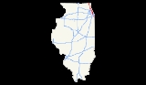
Interstate 94 in Illinois
Encyclopedia
In the U.S. state
of Illinois
, Interstate 94
generally runs north–south through the northeastern portion of the state, in Lake
and Cook Counties
. It is marked east–west in Illinois in accordance with its general alignment across the country, although some entrances on the Tri-State Tollway
have north or south I-94 signs. I-94 in Illinois is 78 miles (125.53 km) long.
for I-94 generally are Wisconsin or Milwaukee
to the north and west, Chicago or Chicago Loop for those heading to the central portion, and Indiana to the south and east.
and the Gurnee Mills
mall; extensive office developments and residential districts in southern Lake County and the North Shore region of Cook County, and serves the Old Orchard Shopping Center
; the length of the city of Chicago, running just west of the Chicago Loop
on the Kennedy Expressway
.
I-94 has 6 lanes (3 in each direction) from the state line to Illinois Route 173
(Rosecrans Road) with wide shoulders planned to be 8 by 2015-2016 (same time as the I-94 in WI work). At this point it becomes 8 lanes wide until just north of Deerfield Road where it widens further to 10 lanes as it approaches Interstate 294
and the Edens Spur. This is where 3 lanes branch off and begin I-294 while 2 lanes for I-94 head east onto the Edens Spur which only has four lanes total (two in each direction).
The highway turns south and widens back to six lanes on the Edens Expressway, and to ten lanes (four lanes in each direction + two reversible lanes) along the Kennedy Expressway. At Ohio Street, the reversible lanes terminate and the highway has 10 lanes to Circle Interchange
, where the left lane ends and the right lane exits onto the Eisenhower Expressway.
Mileposts along the portion of I-94 that are part of the Tri-State Tollway reflect the distance from the southeastern terminus of the tollway, leading to a counterintuitive increase in the mile numbers as one proceeds "west."
, Calumet City
, and South Holland, Illinois
, until it joins Interstate 80
on the Kingery Expressway
, which finally enters Indiana
east of Lansing, Illinois
.
I-94 has ten lanes (five in each direction) from the exit ramps of the Circle Interchange to the Stevenson Expressway
. It then splits into a 14 lane expressway on the Dan Ryan, with three and four lanes alternating between the local and express lanes in both directions. At the Chicago Skyway, a two lane ramp carries traffic to I-90, leaving ten lanes (five in each direction) running south to the I-57/I-94 junction.
From I-57 to Cottage Grove Avenue, I-94 has four lanes (two lanes each way), with six lanes (three lanes each way) between Michigan Avenue and Cottage Grove Avenue. The freeway connection ramp to Stony Island Avenue
has four lanes (two in each direction). I-94 then has six lanes (three in each direction) south to I-80. On the ramps to and from I-80, I-94 has two lanes in each direction. On I-80 itself, I-94 widens to eight lanes (four in each direction) to the state line.
The section including the Southland Interchange with I-80 and 294
was reconfigured as part of the Kingery Expressway
reconstruction project, completed in 2007, including 4 lanes south of 159th Street, with the split between I-80 and 94 East to the left, and I-80 West, I-294 North, and Ill. 394 South on the right located north of the 170th St. overpass. The configuration of I-80 and 94 is discussed in connection with the Kingery Expressway
.
and follow Lake Shore Drive
along Lake Michigan
. After local opposition prevented I-494 and I-694 from being completed, both numbers were completely dropped. Portions of the old I-494/I-694 exist as US 41/Lake Shore Drive and the Ohio Street connector. In addition, I-494 was also planned at one point to be a western bypass of Chicago, as the Crosstown Expressway
.
From 2007-2009 Interstate 94 was widened from 6 to 8 lanes between Illinois Route 173
(Rosecrans Road) and Illinois Route 22
(Half Day Road).
.
.
U.S. state
A U.S. state is any one of the 50 federated states of the United States of America that share sovereignty with the federal government. Because of this shared sovereignty, an American is a citizen both of the federal entity and of his or her state of domicile. Four states use the official title of...
of Illinois
Illinois
Illinois is the fifth-most populous state of the United States of America, and is often noted for being a microcosm of the entire country. With Chicago in the northeast, small industrial cities and great agricultural productivity in central and northern Illinois, and natural resources like coal,...
, Interstate 94
Interstate 94
Interstate 94 is the northernmost east–west Interstate Highway, connecting the Great Lakes and Intermountain regions of the United States. I-94's western terminus is in Billings, Montana at a junction with Interstate 90; its eastern terminus is the U.S...
generally runs north–south through the northeastern portion of the state, in Lake
Lake County, Illinois
Lake County is a county in the northeastern corner of the state of Illinois, on the shore of Lake Michigan. According to the 2010 census, it has a population of 703,462, which is an increase of 9.2% from 644,356 in 2000. Its county seat is Waukegan. The county is part of the Chicago metropolitan area...
and Cook Counties
Cook County, Illinois
Cook County is a county in the U.S. state of Illinois, with its county seat in Chicago. It is the second most populous county in the United States after Los Angeles County. The county has 5,194,675 residents, which is 40.5 percent of all Illinois residents. Cook County's population is larger than...
. It is marked east–west in Illinois in accordance with its general alignment across the country, although some entrances on the Tri-State Tollway
Tri-State Tollway
The Tri-State Tollway is a U.S. toll road maintained by the Illinois State Toll Highway Authority in northeastern Illinois which is considered one of the most heavily traveled highways in the country...
have north or south I-94 signs. I-94 in Illinois is 78 miles (125.53 km) long.
Route description
The control citiesControl city
A control city is a city or locality posted on a traffic sign indicating forward destinations on a certain route. These destinations aid motorists using the highway system to reach destinations along the various routes...
for I-94 generally are Wisconsin or Milwaukee
Milwaukee, Wisconsin
Milwaukee is the largest city in the U.S. state of Wisconsin, the 28th most populous city in the United States and 39th most populous region in the United States. It is the county seat of Milwaukee County and is located on the southwestern shore of Lake Michigan. According to 2010 census data, the...
to the north and west, Chicago or Chicago Loop for those heading to the central portion, and Indiana to the south and east.
Wisconsin to Downtown Chicago
I-94 traverses rural and suburban areas in Lake County, and serves Six Flags Great AmericaSix Flags Great America
Six Flags Great America is a Six Flags theme park in the Chicago metropolitan area, located in Gurnee, Illinois. It first opened in 1976 as Marriott's Great America. Six Flags purchased the park from the Marriott Corporation in 1984, making it the seventh park in the chain...
and the Gurnee Mills
Gurnee Mills
Gurnee Mills is an indoor mall, established in Gurnee, Illinois. It's located about halfway between Chicago and Milwaukee, Wisconsin, a 40 minute drive either way, and near Six Flags Great America. It is a single-level Z-shaped mall. At of gross leasable area, it is the fourth largest mall in...
mall; extensive office developments and residential districts in southern Lake County and the North Shore region of Cook County, and serves the Old Orchard Shopping Center
Westfield Old Orchard
Westfield Old Orchard, formerly Old Orchard Shopping Center, is an open-air upscale shopping center in Skokie, Illinois. It is the third largest mall by total square footage in Illinois. Its anchor stores are Bloomingdale's, Macy's , Lord & Taylor, L.L. Bean and Nordstrom...
; the length of the city of Chicago, running just west of the Chicago Loop
Chicago Loop
The Loop or Chicago Loop is one of 77 officially designated Chicago community areas located in the City of Chicago, Illinois. It is the historic commercial center of downtown Chicago...
on the Kennedy Expressway
Kennedy Expressway
The John F. Kennedy Expressway is a long highway that travels northwest from the Chicago Loop to O'Hare International Airport. The expressway is named for the 35th U.S. President, John F. Kennedy. The Interstate 90 portion of the Kennedy is a part of the much longer I-90...
.
I-94 has 6 lanes (3 in each direction) from the state line to Illinois Route 173
Illinois Route 173
Illinois Route 173 is an east–west state road that runs from Illinois Route 251 in the Rockford suburb of Machesney Park east to Illinois Route 137 in Zion near the Illinois-Wisconsin border; this is a distance of . Illinois Route 173 is also one of the northernmost east-west state highways...
(Rosecrans Road) with wide shoulders planned to be 8 by 2015-2016 (same time as the I-94 in WI work). At this point it becomes 8 lanes wide until just north of Deerfield Road where it widens further to 10 lanes as it approaches Interstate 294
Interstate 294
Interstate 294 is a tolled Interstate Highway in northeastern Illinois, U.S.A.. It forms the southern portion of the Tri-State Tollway in Illinois. I-294 runs from South Holland at Interstates 80 and 94, and Illinois Route 394 to Northbrook at I-94. Interstate 294 is long; are shared with I-80....
and the Edens Spur. This is where 3 lanes branch off and begin I-294 while 2 lanes for I-94 head east onto the Edens Spur which only has four lanes total (two in each direction).
The highway turns south and widens back to six lanes on the Edens Expressway, and to ten lanes (four lanes in each direction + two reversible lanes) along the Kennedy Expressway. At Ohio Street, the reversible lanes terminate and the highway has 10 lanes to Circle Interchange
Circle Interchange
The Circle Interchange is an expressway interchange near downtown Chicago, Illinois. It is the junction between the Dan Ryan, Eisenhower and Kennedy expressways...
, where the left lane ends and the right lane exits onto the Eisenhower Expressway.
Mileposts along the portion of I-94 that are part of the Tri-State Tollway reflect the distance from the southeastern terminus of the tollway, leading to a counterintuitive increase in the mile numbers as one proceeds "west."
Downtown Chicago to Indiana
South of downtown Chicago, I-94 serves the southeast suburbs of Chicago, including DoltonDolton, Illinois
Dolton is a village in Cook County, Illinois, United States. The population was 25,614 at the 2000 census. Dolton is located just west of the expressway Interstate 94 and immediately south of the city limits of Chicago. Its most common ZIP code is 60419....
, Calumet City
Calumet City, Illinois
Calumet City is a city in Cook County, Illinois, United States. The population was 39,072 at the 2000 census. The ZIP code is 60409.Calumet City was founded in 1892 when the villages of Schrumville and Sobieski Park merged under the name of West Hammond, since it lies on the west side of the...
, and South Holland, Illinois
South Holland, Illinois
South Holland is a village in Cook County, Illinois, United States and serves as the seat of Thornton Township. The population was 22,147 at the 2000 census.-History:...
, until it joins Interstate 80
Interstate 80 in Illinois
In the U.S. state of Illinois, Interstate 80 is an Interstate Highway that runs from the Quad Cities east to south of Chicago. It is a main east–west route for trafficcoming and going through Illinois, especially for cross-country truckers....
on the Kingery Expressway
Kingery Expressway
The Robert Kingery Expressway, formerly called the Tri-State Highway, is a three-mile-long , eight-lane expressway in northeastern Illinois...
, which finally enters Indiana
Indiana
Indiana is a US state, admitted to the United States as the 19th on December 11, 1816. It is located in the Midwestern United States and Great Lakes Region. With 6,483,802 residents, the state is ranked 15th in population and 16th in population density. Indiana is ranked 38th in land area and is...
east of Lansing, Illinois
Lansing, Illinois
Lansing is a village in Cook County, Illinois, USA. Lansing is a southern suburb of Chicago. The population was 28,332 at the 2000 census.-Geography:...
.
I-94 has ten lanes (five in each direction) from the exit ramps of the Circle Interchange to the Stevenson Expressway
Stevenson Expressway
The Stevenson Expressway is the major Interstate highway leading southwest out of the city of Chicago in Illinois. It is signed as Interstate 55 for the entire length....
. It then splits into a 14 lane expressway on the Dan Ryan, with three and four lanes alternating between the local and express lanes in both directions. At the Chicago Skyway, a two lane ramp carries traffic to I-90, leaving ten lanes (five in each direction) running south to the I-57/I-94 junction.
From I-57 to Cottage Grove Avenue, I-94 has four lanes (two lanes each way), with six lanes (three lanes each way) between Michigan Avenue and Cottage Grove Avenue. The freeway connection ramp to Stony Island Avenue
Stony Island Avenue
Stony Island Avenue is a major thoroughfare on South Side of the city of Chicago, designated 1600 East in Chicago's street numbering system. It runs from 56th Street south to the Calumet River. Stony Island Avenue continues sporadically south of the Calumet in the southern suburbs, running...
has four lanes (two in each direction). I-94 then has six lanes (three in each direction) south to I-80. On the ramps to and from I-80, I-94 has two lanes in each direction. On I-80 itself, I-94 widens to eight lanes (four in each direction) to the state line.
The section including the Southland Interchange with I-80 and 294
was reconfigured as part of the Kingery Expressway
Kingery Expressway
The Robert Kingery Expressway, formerly called the Tri-State Highway, is a three-mile-long , eight-lane expressway in northeastern Illinois...
reconstruction project, completed in 2007, including 4 lanes south of 159th Street, with the split between I-80 and 94 East to the left, and I-80 West, I-294 North, and Ill. 394 South on the right located north of the 170th St. overpass. The configuration of I-80 and 94 is discussed in connection with the Kingery Expressway
Kingery Expressway
The Robert Kingery Expressway, formerly called the Tri-State Highway, is a three-mile-long , eight-lane expressway in northeastern Illinois...
.
History
Interstate 494 (and later Interstate 694) was originally planned to serve as a loop in ChicagoChicago
Chicago is the largest city in the US state of Illinois. With nearly 2.7 million residents, it is the most populous city in the Midwestern United States and the third most populous in the US, after New York City and Los Angeles...
and follow Lake Shore Drive
Lake Shore Drive
Lake Shore Drive is a mostly freeway-standard expressway running parallel with and alongside the shoreline of Lake Michigan through Chicago, Illinois, USA. Except for the portion north of Foster Avenue , Lake Shore Drive is designated as part of U.S...
along Lake Michigan
Lake Michigan
Lake Michigan is one of the five Great Lakes of North America and the only one located entirely within the United States. It is the second largest of the Great Lakes by volume and the third largest by surface area, after Lake Superior and Lake Huron...
. After local opposition prevented I-494 and I-694 from being completed, both numbers were completely dropped. Portions of the old I-494/I-694 exist as US 41/Lake Shore Drive and the Ohio Street connector. In addition, I-494 was also planned at one point to be a western bypass of Chicago, as the Crosstown Expressway
Crosstown Expressway (Interstate 494)
The Crosstown Expressway , was a proposed highway route in Chicago, Illinois in the 1960s through the 1970s.-Route description:...
.
From 2007-2009 Interstate 94 was widened from 6 to 8 lanes between Illinois Route 173
Illinois Route 173
Illinois Route 173 is an east–west state road that runs from Illinois Route 251 in the Rockford suburb of Machesney Park east to Illinois Route 137 in Zion near the Illinois-Wisconsin border; this is a distance of . Illinois Route 173 is also one of the northernmost east-west state highways...
(Rosecrans Road) and Illinois Route 22
Illinois Route 22
Illinois Route 22, also known as Half Day Road for part of its length, is an east–west state highway in northeastern Illinois. It runs from U.S. Route 14 in Fox River Grove to U.S. Route 41 in Highland Park...
(Half Day Road).
Tri-State Tollway
See Tri-State Tollway for exits on the Tri-State Tollway.Edens Expressway
| County | Location | Mile | # Exit number An exit number is a number assigned to a road junction, usually an exit from a freeway. It is usually marked on the same sign as the destinations of the exit, as well as a sign in the gore.... |
Destinations | Notes |
|---|---|---|---|---|---|
 I-94 runs west onto the Edens Spur I-94 runs west onto the Edens Spur |
|||||
| Cook Cook County, Illinois Cook County is a county in the U.S. state of Illinois, with its county seat in Chicago. It is the second most populous county in the United States after Los Angeles County. The county has 5,194,675 residents, which is 40.5 percent of all Illinois residents. Cook County's population is larger than... |
Northbrook Northbrook, Illinois Northbrook is a village located at the northern edge of Cook County, Illinois, which is also a North Shore suburb of Chicago. The population was 33,170 at the 2010 census.... |
29.96 | 29 |  U.S. Route 41 U.S. Route 41U.S. Route 41 U.S. Route 41 is a north–south United States Highway that runs from Miami, Florida to the Upper Peninsula of Michigan. Until 1949, the part in southern Florida, from Naples to Miami, was U.S... North (Skokie Highway Skokie Highway The Skokie Highway is a major arterial highway running north of Chicago through the far northeastern portion of the U.S. state of Illinois. It runs from the intersection of Illinois Route 50 in Skokie north to the Wisconsin state line at Interstate 94 near Wadsworth. All of the Skokie Highway is... ) |
I-94 continues west onto the Tri-State Tollway Tri-State Tollway The Tri-State Tollway is a U.S. toll road maintained by the Illinois State Toll Highway Authority in northeastern Illinois which is considered one of the most heavily traveled highways in the country... . Southbound U.S. 41 joins I-94 traveling eastbound. No access to northbound U.S. 41 from I-94 EB. |
| 30.23 | 30A-B |  Illinois Route 68 Illinois Route 68Illinois Route 68 Illinois Route 68 is an east–west state highway in northeast Illinois. It runs east from Illinois Route 72 in the Dundee area to the Interstate 94/U.S. Route 41 concurrency in Glencoe. This is a distance of .... West — Dundee Road |
Eastern terminus of Illinois 68. Westbound exits, eastbound entrances. Northbrook Northbrook, Illinois Northbrook is a village located at the northern edge of Cook County, Illinois, which is also a North Shore suburb of Chicago. The population was 33,170 at the 2010 census.... |
||
| Northfield Northfield, Illinois Northfield is an affluent village in Cook County, Illinois, United States. It is located approximately north of Chicago. As of the 2000 census, the village population was 5,389... |
31.92 | 31 | Tower Road | Westbound entrance, eastbound exit. Tower Road East goes to Winnetka Winnetka, Illinois Winnetka is an affluent North Shore village located approximately north of downtown Chicago in Cook County, Illinois. Winnetka was featured on the list of America's 25 top-earning towns and "one of the best places to live" by CNN Money in 2011... ; access to Northfield and Willow Road via West Frontage Road. |
|
| 33.04 | 33A-B | Willow Road | Westbound exit, eastbound entrance. Winnetka |
||
| Wilmette Wilmette, Illinois Wilmette is a village in New Trier Township, Cook County, Illinois, United States. It is located north of Chicago's downtown district and has a population of 27,651. Wilmette is considered a bedroom community in the North Shore district... |
33.95 | 34A | U.S. Route 41 U.S. Route 41 U.S. Route 41 is a north–south United States Highway that runs from Miami, Florida to the Upper Peninsula of Michigan. Until 1949, the part in southern Florida, from Naples to Miami, was U.S... South — Skokie Road |
Westbound entrance, eastbound exit. | |
| 34.58 | 34B-C | Lake Avenue | Westbound exit, eastbound entrance. | ||
| Skokie Skokie, Illinois Skokie is a village in Cook County, Illinois, United States. Its name comes from a Native American word for "fire". A Chicago suburb, for many years Skokie promoted itself as "The World's Largest Village". Its population, per the 2000 census, was 63,348... |
35.84 | 35 | Old Orchard Road (10000 North) | Access to Old Orchard Mall | |
| 37.38 | 37A-B |  Illinois Route 58 Illinois Route 58Illinois Route 58 Illinois Route 58 is a state highway in northeast Illinois. It runs from Illinois Route 25 in Elgin east to U.S. Route 41 in Skokie... — Dempster Street (8800 north) |
Signed to Northwestern University Northwestern University Northwestern University is a private research university in Evanston and Chicago, Illinois, USA. Northwestern has eleven undergraduate, graduate, and professional schools offering 124 undergraduate degrees and 145 graduate and professional degrees.... . Morton Grove Morton Grove, Illinois Morton Grove is a village in Cook County, Illinois, United States. The population was 22,451 at the 2000 census.The Village President of Morton Grove since April 27, 2009, is Daniel J... |
||
| Lincolnwood Lincolnwood, Illinois Lincolnwood is a village in Cook County, Illinois, United States. The population was 12,359 at the 2000 census.-Geography:Lincolnwood is located at .... |
39.87 | 39A-B | Touhy Avenue Touhy Avenue Touhy Avenue is a major thoroughfare throughout northern Chicago, Illinois as well as the north and northwestern suburbs of the city. It is named for Patrick L. Touhy, a subdivider who was also the son-in-law of Phillip Rogers, an early settler who helped develop Rogers Park... (7200 North) |
Westbound exit to Touhy Avenue East utilizes  Illinois Route 50 Illinois Route 50Illinois Route 50 Illinois Route 50 is a north–south state road in northeastern Illinois. It runs from the junction with U.S. Route 45 in West Kankakee north to U.S. Route 41 in Skokie. This is a distance of . In Chicago and the suburbs it's known as Cicero Avenue... — Cicero Avenue. Western portion of interchange is in Skokie. |
|
| Chicago Chicago Chicago is the largest city in the US state of Illinois. With nearly 2.7 million residents, it is the most populous city in the Midwestern United States and the third most populous in the US, after New York City and Los Angeles... |
41.37 | 41A-B |  U.S. Route 14 U.S. Route 14U.S. Route 14 U.S. Route 14 , an east–west route, is one of the original United States highways of 1926. It currently has a length of 1,398 miles , but it had a peak length of 1,429 miles . For much of its length, it runs roughly parallel to Interstate 90.As of 2004, the highway's eastern terminus is in... — Peterson Avenue / Caldwell Avenue (6000 North) |
Eastbound exit only to Peterson eastbound; Caldwell entrance only to I-94 East. | |
| 41.91 | 41C | Illinois Route 50 Illinois Route 50 Illinois Route 50 is a north–south state road in northeastern Illinois. It runs from the junction with U.S. Route 45 in West Kankakee north to U.S. Route 41 in Skokie. This is a distance of . In Chicago and the suburbs it's known as Cicero Avenue... South — Cicero Avenue (4800 West) |
Eastbound exit only. Signed to  Interstate 90 Interstate 90Interstate 90 Interstate 90 is the longest Interstate Highway in the United States at . It is the northernmost coast-to-coast interstate, and parallels US 20 for the most part. Its western terminus is in Seattle, at Edgar Martinez Drive S. near Safeco Field and CenturyLink Field, and its eastern terminus is in... West; O'Hare Field; Foster Avenue. |
||
| 42.49 | 42 | Foster Avenue Foster Avenue (Chicago) Foster Avenue is a major east-west street on the North Side of Chicago as well as the northwestern suburbs. Foster Avenue separates the Chicago lakefront neighborhoods of Edgewater to the north and Uptown to the south.... (5200 North) |
Entrance and exit to I-94 West only. | ||
| 43.52 | 43A | Wilson Avenue (4600 North) | |||
| 43.32 | 43B (WB) | Interstate 90 Interstate 90 Interstate 90 is the longest Interstate Highway in the United States at . It is the northernmost coast-to-coast interstate, and parallels US 20 for the most part. Its western terminus is in Seattle, at Edgar Martinez Drive S. near Safeco Field and CenturyLink Field, and its eastern terminus is in... East (Kennedy Expressway Kennedy Expressway The John F. Kennedy Expressway is a long highway that travels northwest from the Chicago Loop to O'Hare International Airport. The expressway is named for the 35th U.S. President, John F. Kennedy. The Interstate 90 portion of the Kennedy is a part of the much longer I-90... ) — Chicago Loop Chicago Loop The Loop or Chicago Loop is one of 77 officially designated Chicago community areas located in the City of Chicago, Illinois. It is the historic commercial center of downtown Chicago... |
Also known as The Junction. EB I-94 joins I-90 traveling eastbound. Exits to eastbound express and local lanes. No access to westbound I-90 traveling eastbound (use Exit 41C, Cicero Avenue and Foster Avenue). | ||
| I-90/94 continues south as the Kennedy Expressway Kennedy Expressway The John F. Kennedy Expressway is a long highway that travels northwest from the Chicago Loop to O'Hare International Airport. The expressway is named for the 35th U.S. President, John F. Kennedy. The Interstate 90 portion of the Kennedy is a part of the much longer I-90... |
|||||
Kennedy Expressway
See Interstate 90 in Illinois for exits on the Kennedy ExpresswayKennedy Expressway
The John F. Kennedy Expressway is a long highway that travels northwest from the Chicago Loop to O'Hare International Airport. The expressway is named for the 35th U.S. President, John F. Kennedy. The Interstate 90 portion of the Kennedy is a part of the much longer I-90...
.
Bishop Ford Freeway
| County | Location | Mile | # Exit number An exit number is a number assigned to a road junction, usually an exit from a freeway. It is usually marked on the same sign as the destinations of the exit, as well as a sign in the gore.... |
Destinations | Notes |
|---|---|---|---|---|---|
| I-94 continues north onto the Dan Ryan Expressway Dan Ryan Expressway The Dan Ryan is an expressway in the city of Chicago that runs from the Circle Interchange with I-290 near downtown Chicago through the South Side of the city. It is designated as both Interstate 94 and Interstate 90 south to 66th Street, a distance of... |
|||||
| Cook Cook County, Illinois Cook County is a county in the U.S. state of Illinois, with its county seat in Chicago. It is the second most populous county in the United States after Los Angeles County. The county has 5,194,675 residents, which is 40.5 percent of all Illinois residents. Cook County's population is larger than... |
Chicago Chicago Chicago is the largest city in the US state of Illinois. With nearly 2.7 million residents, it is the most populous city in the Midwestern United States and the third most populous in the US, after New York City and Los Angeles... |
63.17 | 63 |  Interstate 57 Interstate 57Interstate 57 Interstate 57 is an Interstate Highway in Missouri and Illinois that parallels the old Illinois Central rail line for much of its route. It goes from Miner, Missouri, at Interstate 55 to Chicago, Illinois, at Interstate 94. I-57 essentially serves as a shortcut route for travelers headed between... South — Memphis, Tennessee Memphis, Tennessee Memphis is a city in the southwestern corner of the U.S. state of Tennessee, and the county seat of Shelby County. The city is located on the 4th Chickasaw Bluff, south of the confluence of the Wolf and Mississippi rivers.... |
Left exit on Bishop Ford Freeway. Northern terminus of Bishop Ford Freeway. Northern terminus of I-57. I-94 continues north onto the Dan Ryan Expressway Dan Ryan Expressway The Dan Ryan is an expressway in the city of Chicago that runs from the Circle Interchange with I-290 near downtown Chicago through the South Side of the city. It is designated as both Interstate 94 and Interstate 90 south to 66th Street, a distance of... . |
| 64.59– 65.56 |
65 | WB (on NB Bishop Ford): Stony Island Avenue (1600 East), 103rd Street EB (on connector): Stony Island Avenue (1600 East), To 95th and 103rd Streets |
Marked as "To U.S. Route 41 U.S. Route 41 U.S. Route 41 is a north–south United States Highway that runs from Miami, Florida to the Upper Peninsula of Michigan. Until 1949, the part in southern Florida, from Naples to Miami, was U.S... — Lake Shore Drive Lake Shore Drive Lake Shore Drive is a mostly freeway-standard expressway running parallel with and alongside the shoreline of Lake Michigan through Chicago, Illinois, USA. Except for the portion north of Foster Avenue , Lake Shore Drive is designated as part of U.S... ". |
||
| 66.18 | 66A | 111th Street | Exit to Pullman Pullman, Chicago Pullman, one of Chicago's 77 community areas, is a neighborhood located on the city's South Side. Twelve miles from the Chicago Loop, Pullman is situated adjacent Lake Calumet.... Historic District |
||
| 66.70 | 66B | 115th Street | |||
| 68.67 | 68A-B | 130th Street | Exit to Illinois International Port Lake Calumet Lake Calumet is the largest body of water within the city of Chicago. Formerly a shallow, postglacial lake draining into Lake Michigan, it has been changed beyond recognition by industrial redevelopment and decay... . |
||
| 69.52 | 69 | Beaubien Forest Preserve | Eastbound exit, westbound entrance. Access to 134th Street. | ||
| 69.91 | Steel Bridge over the Calumet River Calumet River The Calumet River refers to a system of heavily industrialized rivers and canals in the region between the neighborhood of South Chicago in Chicago, Illinois, and the city of Gary, Indiana.-Background:... |
||||
| Calumet City Calumet City, Illinois Calumet City is a city in Cook County, Illinois, United States. The population was 39,072 at the 2000 census. The ZIP code is 60409.Calumet City was founded in 1892 when the villages of Schrumville and Sobieski Park merged under the name of West Hammond, since it lies on the west side of the... |
70.62 | 70A-B | Dolton Avenue | Eastbound exits, westbound entrances. | |
| 71.42 | 71A-B |  Illinois Route 83 Illinois Route 83Illinois Route 83 Illinois Route 83 is a major north–south state road in northeast Illinois. It stretches from U.S. Highway 30 by Lynwood and Dyer, Indiana north to the Wisconsin border by Antioch at Highway 83. Incidentally, this alignment is concentric with Interstate 294... — Sibley Boulevard (15000 South) |
|||
| South Holland South Holland, Illinois South Holland is a village in Cook County, Illinois, United States and serves as the seat of Thornton Township. The population was 22,147 at the 2000 census.-History:... |
72.96 | 73A-B |  U.S. Route 6 U.S. Route 6U.S. Route 6 U.S. Route 6 , also called the Grand Army of the Republic Highway, a name that honors an American Civil War veterans association, is a main route of the U.S. Highway system, running east-northeast from Bishop, California to Provincetown, Massachusetts. Until 1964, it continued south from Bishop to... — 159th Street |
South Holland, Calumet City While signed as 159th Street, U.S. 6 is 162nd Street in South Holland and River Oaks Drive in Calumet City |
|
| 74.40 | 74A |  Illinois Route 394 Illinois Route 394Illinois Route 394 Illinois Route 394 is a four-lane state freeway that travels south from Thornton at the Interstate 294/Interstate 94/Interstate 80 interchange to Illinois Route 1 south of Steger and Crete. Before taking the Illinois 394 route, it was known as Illinois 1... South — Danville Danville, Illinois Danville is a city in Vermilion County, Illinois, United States. It is the principal city of the'Danville, Illinois Metropolitan Statistical Area' which encompasses all of Danville and Vermilion County. As of the 2010 census, the city had a total population of 32,467. It is the county seat of... |
Southern terminus of Bishop Ford Freeway. Southern terminus of Tri-State Tollway and I-294. I-94 continues eastbound with I-80 onto the Kingery Expressway. | ||
| 74.40 | 74B |   Interstates 80 Interstates 80Interstate 80 Interstate 80 is the second-longest Interstate Highway in the United States, following Interstate 90. It is a transcontinental artery running from downtown San Francisco, California to Teaneck, New Jersey in the New York City Metropolitan Area... West/294 Interstate 294 Interstate 294 is a tolled Interstate Highway in northeastern Illinois, U.S.A.. It forms the southern portion of the Tri-State Tollway in Illinois. I-294 runs from South Holland at Interstates 80 and 94, and Illinois Route 394 to Northbrook at I-94. Interstate 294 is long; are shared with I-80.... North (Tri-State Tollway Tri-State Tollway The Tri-State Tollway is a U.S. toll road maintained by the Illinois State Toll Highway Authority in northeastern Illinois which is considered one of the most heavily traveled highways in the country... ) — Iowa Iowa Iowa is a state located in the Midwestern United States, an area often referred to as the "American Heartland". It derives its name from the Ioway people, one of the many American Indian tribes that occupied the state at the time of European exploration. Iowa was a part of the French colony of New... , Wisconsin Wisconsin Wisconsin is a U.S. state located in the north-central United States and is part of the Midwest. It is bordered by Minnesota to the west, Iowa to the southwest, Illinois to the south, Lake Michigan to the east, Michigan to the northeast, and Lake Superior to the north. Wisconsin's capital is... |
|||
| I-80/94 runs east onto the Kingery Expressway Kingery Expressway The Robert Kingery Expressway, formerly called the Tri-State Highway, is a three-mile-long , eight-lane expressway in northeastern Illinois... |
|||||
Kingery Expressway
See Interstate 80 in Illinois for exits on the Kingery ExpresswayKingery Expressway
The Robert Kingery Expressway, formerly called the Tri-State Highway, is a three-mile-long , eight-lane expressway in northeastern Illinois...
.