
Illinois Route 19
Encyclopedia
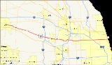
Illinois Route 19 is a major east–west arterial road in northeastern Illinois
, United States
. It runs from Illinois Route 25
(Liberty St.) in Elgin
, to Lake Shore Drive
(U.S. Route 41
) on the north side of Chicago
. Illinois 19 is 33.64 miles (54.14 km) long. For much of its length, it is also known as Irving Park Road.
and Elgin. East of Barrington Road, the road becomes a main artery through the western suburbs of Chicago
. The Elgin-O'Hare Expressway
was built in part to reduce traffic on Illinois 19 through Roselle
and Itasca
.
The road narrows from six to two lanes between Schaumburg
and Roselle, and again (from four lanes to two) in Medinah
and through Itasca. The road then becomes four lanes in Wood Dale
and maintains this width to its eastern terminus, except for a narrower stretch between N. Cumberland Avenue (Illinois 171) and N. Austin Avenue in Chicago.
East of Bensenville
Illinois 19 becomes one of only seven state highways to enter the city of Chicago. It passes along the current southern border of O'Hare International Airport
and serves as the main gateway for western suburbs to access the airport. This stretch of Illinois 19 is part of the proposed O'Hare Ring Road
should the proposed O'Hare runway expansion project succeed. The current road bends around O'Hare's Runway 4 Right, a frequently used arrival and departure runway for O'Hare.
At the Tri-State Tollway
in Schiller Park
, traffic on Illinois 19 may enter the northbound lanes of the tollway. Traffic wishing to enter the southbound lanes must enter at Interstate 190
to the north. The Chicago city limits officially start at the Des Plaines River
. Illinois 19 runs through the O'Hare, Dunning, Portage Park, Irving Park, North Center and Lake View neighborhoods before ending at a traffic signal beneath Lake Shore Drive
(U.S. Route 41
).
The road used to be named Chicago-Elgin Road, but east of Elgin it has been renamed Irving Park Road, for the Irving Park neighborhood located between the Cicero Avenue
and the north branch of the Chicago River
in Chicago. In Elgin itself, it has since been renamed East Chicago Street. As of 2005, some signage on approaching streets still identified Irving Park Road as Chicago-Elgin Road.
. In 1927, the routing was removed, and in 1949 it was reapplied on its modern day routing.
Milwaukee District/West Line
tracks, creating a situation where vehicles on both roads may be at risk of being hit by oncoming commuter trains. In addition, the Soo Line Railroad
runs freight trains on the rail line during off-peak hours. After the $45 million reconstruction, Irving Park Road would have crossed underneath the railroad tracks further northwest from the current intersection. Two alternatives were advanced in a city council meeting: Alternate 2, which would move Irving Park Road slightly north, displace 18 businesses but have flood-plain and line-of-sight issues, and Alternate 2A, which would displace 47 homes and 13 businesses.
The plan was killed in early March 2007 after local opposition to a Division Street extension through property owned by Holy Ghost Church. The city has since decided to investigate alternative safety measures at the intersection, including the addition of turn lanes and red-light cameras.
!County
!Location
!Mile
!Junction
!Notes
|-
|Kane
Mile 0.00-0.22
|Elgin
|0.00
|
|
|-
|rowspan=2|Cook
Mile 0.00-9.32
|Streamwood
|3.65
|
|
|-
|Schaumburg
|8.47
|
|
|-
|rowspan=2|DuPage
Mile 0.00-9.19
|Itasca
|13.16
|
|
|-
|Wood Dale
|17.06
|
|
|-
|rowspan=7|Cook
Mile 9.32-23.79
|rowspan=2|Schiller Park
|20.90
|
|Access to southbound Tri-State Tollway via I-190 east
|-
|21.23
|
|Exit from southbound Tri-State Tollway only.
|-
|rowspan=5|Chicago
|23.36
|
|
|-
|24.88
|
|
|-
|27.97
|
|
|-
|28.80
|
|
|-
|33.64
|
|
Illinois
Illinois is the fifth-most populous state of the United States of America, and is often noted for being a microcosm of the entire country. With Chicago in the northeast, small industrial cities and great agricultural productivity in central and northern Illinois, and natural resources like coal,...
, United States
United States
The United States of America is a federal constitutional republic comprising fifty states and a federal district...
. It runs from Illinois Route 25
Illinois Route 25
Illinois Route 25 is a state road in northeast Illinois. It runs north from U.S. Highway 34 in Oswego to Illinois Route 62 in Algonquin. Illinois 25 is in length.- Route description :...
(Liberty St.) in Elgin
Elgin, Illinois
Elgin is a city in northern Illinois located roughly northwest of Chicago on the Fox River. Most of Elgin lies within Kane County, Illinois, with a portion in Cook County, Illinois...
, to Lake Shore Drive
Lake Shore Drive
Lake Shore Drive is a mostly freeway-standard expressway running parallel with and alongside the shoreline of Lake Michigan through Chicago, Illinois, USA. Except for the portion north of Foster Avenue , Lake Shore Drive is designated as part of U.S...
(U.S. Route 41
U.S. Route 41 in Illinois
In the U.S. state of Illinois, U.S. Route 41 runs north from the Indiana border beneath the Chicago Skyway on Indianapolis Boulevard to the Wisconsin border north of the northern terminus of the Tri-State Tollway with Interstate 94. It is the only north–south U.S...
) on the north side of Chicago
Chicago
Chicago is the largest city in the US state of Illinois. With nearly 2.7 million residents, it is the most populous city in the Midwestern United States and the third most populous in the US, after New York City and Los Angeles...
. Illinois 19 is 33.64 miles (54.14 km) long. For much of its length, it is also known as Irving Park Road.
Route description
Illinois 19 fluctuates from being a two lane road in rural parts to six lanes by highway interchanges. In Elgin, the road is mostly four lanes, narrowing to two in relatively undeveloped, forested sections between Illinois Route 59Illinois Route 59
Illinois Route 59 is a north–south state highway in northeastern Illinois. It runs south from Illinois Route 83 in Antioch to Interstate Highway 55 in Shorewood, spanning the north–south width of Chicago's western suburbs...
and Elgin. East of Barrington Road, the road becomes a main artery through the western suburbs of Chicago
Chicago
Chicago is the largest city in the US state of Illinois. With nearly 2.7 million residents, it is the most populous city in the Midwestern United States and the third most populous in the US, after New York City and Los Angeles...
. The Elgin-O'Hare Expressway
Elgin-O'Hare Expressway
The Elgin-O'Hare Expressway is an Interstate-standard freeway in northeast Illinois, United States. Contrary to its given name, the expressway does not enter either Elgin or O'Hare International Airport, giving it a somewhat infamous reputation as a "road to nowhere"...
was built in part to reduce traffic on Illinois 19 through Roselle
Roselle, Illinois
Roselle is a city located in DuPage County and a small portion in Cook County Illinois in northeastern Illinois. It was first incorporated in 1922 and can correctly be relegated to a bedroom community — that is, a community that largely consists of residential zoning in both income streams...
and Itasca
Itasca, Illinois
Itasca is a village in DuPage County, Illinois, United States. The population was 8,302 at the 2000 census.In 2009, BusinessWeek rated Itasca as the 'Best Affordable Suburb' in the state of Illinois...
.
The road narrows from six to two lanes between Schaumburg
Schaumburg, Illinois
Schaumburg is a city located in Cook County in northeastern Illinois. A common misspelling of the city name is Schaumberg, a spelling which persists on some modern maps. Schaumburg is located just under northwest of downtown Chicago and approximately northwest of O'Hare International Airport. As...
and Roselle, and again (from four lanes to two) in Medinah
Medinah, Illinois
Medinah is an unincorporated community in the northeastern part of the U.S. state of Illinois and is a suburb of Chicago. Medinah, largely located in DuPage County, is situated between the villages of Roselle, Itasca, Bloomingdale, and Addison...
and through Itasca. The road then becomes four lanes in Wood Dale
Wood Dale, Illinois
Wood Dale is a city in DuPage County, Illinois, United States. The population was 13,535 at the 2000 census.-Geography:Wood Dale is located at .According to the United States Census Bureau, the city has a total area of , all of it land.-Demographics:...
and maintains this width to its eastern terminus, except for a narrower stretch between N. Cumberland Avenue (Illinois 171) and N. Austin Avenue in Chicago.
East of Bensenville
Bensenville, Illinois
Bensenville is a village located primarily in DuPage County, Illinois, with a small section near O'Hare International Airport in Cook County, Illinois, overlapping into the city of Chicago. As of the 2000 census, the village population was 20,703. Bensenville is home to the Edge Ice Arena, home of...
Illinois 19 becomes one of only seven state highways to enter the city of Chicago. It passes along the current southern border of O'Hare International Airport
O'Hare International Airport
Chicago O'Hare International Airport , also known as O'Hare Airport, O'Hare Field, Chicago Airport, Chicago International Airport, or simply O'Hare, is a major airport located in the northwestern-most corner of Chicago, Illinois, United States, northwest of the Chicago Loop...
and serves as the main gateway for western suburbs to access the airport. This stretch of Illinois 19 is part of the proposed O'Hare Ring Road
O'Hare Ring Road
The O'Hare Ring Road is a proposed, highly controversial Interstate-standard expressway near Chicago that would run south from Interstate 90 , to the still-unbuilt eastern segment of the Elgin-O'Hare Expressway, to a western access point into O'Hare International Airport, and then east to the...
should the proposed O'Hare runway expansion project succeed. The current road bends around O'Hare's Runway 4 Right, a frequently used arrival and departure runway for O'Hare.
At the Tri-State Tollway
Tri-State Tollway
The Tri-State Tollway is a U.S. toll road maintained by the Illinois State Toll Highway Authority in northeastern Illinois which is considered one of the most heavily traveled highways in the country...
in Schiller Park
Schiller Park, Illinois
Schiller Park is a village in Cook County, Illinois, United States. The population was 11,850 at the 2000 census.-Geography:Schiller Park is located at .According to the United States Census Bureau, the village has a total area of , all of it land....
, traffic on Illinois 19 may enter the northbound lanes of the tollway. Traffic wishing to enter the southbound lanes must enter at Interstate 190
Interstate 190 (Illinois)
Interstate 190 is an intrastate Interstate Highway in the U.S. state of Illinois. I-190 runs west from I-90 to O'Hare International Airport. This is a distance of . Interstate 190 is the westernmost leg of the Kennedy Expressway...
to the north. The Chicago city limits officially start at the Des Plaines River
Des Plaines River
The Des Plaines River is a river that flows southward for through southern Wisconsin and northern Illinois in the U.S. Midwest, eventually meeting the Kankakee River west of Channahon to form the Illinois River, a tributary of the Mississippi River....
. Illinois 19 runs through the O'Hare, Dunning, Portage Park, Irving Park, North Center and Lake View neighborhoods before ending at a traffic signal beneath Lake Shore Drive
Lake Shore Drive
Lake Shore Drive is a mostly freeway-standard expressway running parallel with and alongside the shoreline of Lake Michigan through Chicago, Illinois, USA. Except for the portion north of Foster Avenue , Lake Shore Drive is designated as part of U.S...
(U.S. Route 41
U.S. Route 41
U.S. Route 41 is a north–south United States Highway that runs from Miami, Florida to the Upper Peninsula of Michigan. Until 1949, the part in southern Florida, from Naples to Miami, was U.S...
).
The road used to be named Chicago-Elgin Road, but east of Elgin it has been renamed Irving Park Road, for the Irving Park neighborhood located between the Cicero Avenue
Illinois Route 50
Illinois Route 50 is a north–south state road in northeastern Illinois. It runs from the junction with U.S. Route 45 in West Kankakee north to U.S. Route 41 in Skokie. This is a distance of . In Chicago and the suburbs it's known as Cicero Avenue...
and the north branch of the Chicago River
Chicago River
The Chicago River is a system of rivers and canals with a combined length of that runs through the city of the same name, including its center . Though not especially long, the river is notable for being the reason why Chicago became an important location, as the link between the Great Lakes and...
in Chicago. In Elgin itself, it has since been renamed East Chicago Street. As of 2005, some signage on approaching streets still identified Irving Park Road as Chicago-Elgin Road.
History
The original Route 19 was designated in 1918 as what is now U.S. Route 14U.S. Route 14 in Illinois
In the U.S. state of Illinois, U.S. Route 14 is a major arterial that runs southeast from the Wisconsin state line north of Harvard, Illinois to the north side of Chicago at U.S. Route 41....
. In 1927, the routing was removed, and in 1949 it was reapplied on its modern day routing.
Wood Dale proposed underpass
On November 16, 2006, aldermen in Wood Dale approved a plan to redesign the intersection of Irving Park Road and Wood Dale Road. The intersection is currently fully interconnected to railroad signals for the active MetraMetra
Metra is the commuter rail division of the Illinois Regional Transportation Authority. The system serves Chicago and its metropolitan area through 240 stations on 11 different rail lines. Throughout the 21st century, Metra has been the second busiest commuter rail system in the United States by...
Milwaukee District/West Line
Milwaukee District/West Line
The Milwaukee District/West is a commuter rail line provided and operated by Metra in Chicago, Illinois, and its surrounding suburbs...
tracks, creating a situation where vehicles on both roads may be at risk of being hit by oncoming commuter trains. In addition, the Soo Line Railroad
Soo Line Railroad
The Soo Line Railroad is the primary United States railroad subsidiary of the Canadian Pacific Railway , controlled through the Soo Line Corporation, and one of seven U.S. Class I railroads. Although it is named for the Minneapolis, St. Paul and Sault Ste...
runs freight trains on the rail line during off-peak hours. After the $45 million reconstruction, Irving Park Road would have crossed underneath the railroad tracks further northwest from the current intersection. Two alternatives were advanced in a city council meeting: Alternate 2, which would move Irving Park Road slightly north, displace 18 businesses but have flood-plain and line-of-sight issues, and Alternate 2A, which would displace 47 homes and 13 businesses.
The plan was killed in early March 2007 after local opposition to a Division Street extension through property owned by Holy Ghost Church. The city has since decided to investigate alternative safety measures at the intersection, including the addition of turn lanes and red-light cameras.
Major junctions
{|class=wikitable!County
!Location
!Mile
!Junction
!Notes
|-
|Kane
Kane County, Illinois
Kane County is a county located in the U.S. state of Illinois. According to the 2010 census, it has a population of 515,269, which is an increase of 27.5% from 404,119 in 2000. Its county seat is Geneva, and its largest city is Aurora.- Geography :...
Mile 0.00-0.22
|Elgin
Elgin, Illinois
Elgin is a city in northern Illinois located roughly northwest of Chicago on the Fox River. Most of Elgin lies within Kane County, Illinois, with a portion in Cook County, Illinois...
|0.00
|
|
|-
|rowspan=2|Cook
Cook County, Illinois
Cook County is a county in the U.S. state of Illinois, with its county seat in Chicago. It is the second most populous county in the United States after Los Angeles County. The county has 5,194,675 residents, which is 40.5 percent of all Illinois residents. Cook County's population is larger than...
Mile 0.00-9.32
|Streamwood
Streamwood, Illinois
Streamwood is a village of Cook County, Illinois, United States. The population was 39,497 at the 2006 census. It is a suburb of Chicago.Streamwood, along with Bartlett and Hanover Park, is one of the three communities that make up the so called "Tri Village" area...
|3.65
|
|
|-
|Schaumburg
Schaumburg, Illinois
Schaumburg is a city located in Cook County in northeastern Illinois. A common misspelling of the city name is Schaumberg, a spelling which persists on some modern maps. Schaumburg is located just under northwest of downtown Chicago and approximately northwest of O'Hare International Airport. As...
|8.47
|
|
|-
|rowspan=2|DuPage
DuPage County, Illinois
As of the 2010 Census, the population of the county was 916,924, White Americans made up 77.9% of Dupage County's population; non-Hispanic whites represented 70.5% of the population. Black Americans made up 4.6% of the population. Native Americans made up 0.3% of Dupage County's population...
Mile 0.00-9.19
|Itasca
Itasca, Illinois
Itasca is a village in DuPage County, Illinois, United States. The population was 8,302 at the 2000 census.In 2009, BusinessWeek rated Itasca as the 'Best Affordable Suburb' in the state of Illinois...
|13.16
|
|
|-
|Wood Dale
Wood Dale, Illinois
Wood Dale is a city in DuPage County, Illinois, United States. The population was 13,535 at the 2000 census.-Geography:Wood Dale is located at .According to the United States Census Bureau, the city has a total area of , all of it land.-Demographics:...
|17.06
|
|
|-
|rowspan=7|Cook
Cook County, Illinois
Cook County is a county in the U.S. state of Illinois, with its county seat in Chicago. It is the second most populous county in the United States after Los Angeles County. The county has 5,194,675 residents, which is 40.5 percent of all Illinois residents. Cook County's population is larger than...
Mile 9.32-23.79
|rowspan=2|Schiller Park
Schiller Park, Illinois
Schiller Park is a village in Cook County, Illinois, United States. The population was 11,850 at the 2000 census.-Geography:Schiller Park is located at .According to the United States Census Bureau, the village has a total area of , all of it land....
|20.90
|
|Access to southbound Tri-State Tollway via I-190 east
|-
|21.23
|
|Exit from southbound Tri-State Tollway only.
|-
|rowspan=5|Chicago
Chicago
Chicago is the largest city in the US state of Illinois. With nearly 2.7 million residents, it is the most populous city in the Midwestern United States and the third most populous in the US, after New York City and Los Angeles...
|23.36
|
|
|-
|24.88
|
|
|-
|27.97
|
|
|-
|28.80
|
|
|-
|33.64
|
|